
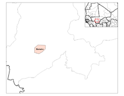
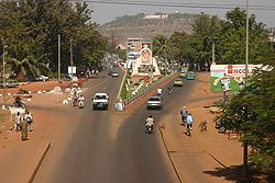
Bamako
Encyclopedia
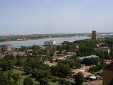
Bamako is the capital of Mali
Mali
Mali , officially the Republic of Mali , is a landlocked country in Western Africa. Mali borders Algeria on the north, Niger on the east, Burkina Faso and the Côte d'Ivoire on the south, Guinea on the south-west, and Senegal and Mauritania on the west. Its size is just over 1,240,000 km² with...
and its largest city with a population of 1.8 million (2009 Census, provisional). Currently, it is estimated to be the fastest growing city in Africa and sixth fastest in the world. It is located on the Niger River
Niger River
The Niger River is the principal river of western Africa, extending about . Its drainage basin is in area. Its source is in the Guinea Highlands in southeastern Guinea...
, near the rapids that divide the upper and middle Niger valleys in the southwestern part of the country.
Bamako is the nation's administrative center. The city proper is cercle
Cercles of Mali
A cercle is the second level administrative unit in Mali. Mali is divided into eight regions and one capital district . These subdivisions bear the name of their principal city. The regions are divided into 49 cercles....
by its own right. Bamako's river port is located in nearby Koulikoro
Koulikoro
Koulikoro is a city in Mali. The capital of the Koulikoro Region, Koulikoro is located on banks of the Niger River, from Mali's capital Bamako....
along with a major regional trade and conference center. Bamako is the seventh largest West Africa
West Africa
West Africa or Western Africa is the westernmost region of the African continent. Geopolitically, the UN definition of Western Africa includes the following 16 countries and an area of approximately 5 million square km:-Flags of West Africa:...
n urban center after Lagos
Lagos
Lagos is a port and the most populous conurbation in Nigeria. With a population of 7,937,932, it is currently the third most populous city in Africa after Cairo and Kinshasa, and currently estimated to be the second fastest growing city in Africa...
, Abidjan
Abidjan
Abidjan is the economic and former official capital of Côte d'Ivoire, while the current capital is Yamoussoukro. it was the largest city in the nation and the third-largest French-speaking city in the world, after Paris, and Kinshasa but before Montreal...
, Kano
Kano
Kano is a city in Nigeria and the capital of Kano State in Northern Nigeria. Its metropolitan population is the second largest in Nigeria after Lagos. The Kano Urban area covers 137 sq.km and comprises six Local Government Area - Kano Municipal, Fagge, Dala, Gwale, Tarauni and Nassarawa - with a...
, Ibadan
Ibadan
Ibadan is the capital city of Oyo State and the third largest metropolitan area in Nigeria, after Lagos and Kano, with a population of 1,338,659 according to the 2006 census. Ibadan is also the largest metropolitan geographical area...
, Dakar
Dakar
Dakar is the capital city and largest city of Senegal. It is located on the Cap-Vert Peninsula on the Atlantic coast and is the westernmost city on the African mainland...
and Accra
Accra
Accra is the capital and largest city of Ghana, with an urban population of 1,658,937 according to the 2000 census. Accra is also the capital of the Greater Accra Region and of the Accra Metropolitan District, with which it is coterminous...
. Local manufactures include textiles, processed meat, and metal goods. There is commercial fishing on the Niger River.
The name Bamako comes from the Bambara
Bambara language
Bambara, more correctly known as Bamanankan , its designation in the language itself , is a language spoken in Mali by as many as six million people...
word meaning "crocodile river".
History
The area of the city has been continuously inhabited since the Palaeolithic era for more than 150,000 years. The fertile lands of the Niger River Valley provided the people with an abundant food supply and early kingdoms in the area grew wealthy as they established trade routes linking across west Africa the SaharaSahara
The Sahara is the world's second largest desert, after Antarctica. At over , it covers most of Northern Africa, making it almost as large as Europe or the United States. The Sahara stretches from the Red Sea, including parts of the Mediterranean coasts, to the outskirts of the Atlantic Ocean...
and leading to northern Africa and Europe. The early inhabitants traded gold
Gold
Gold is a chemical element with the symbol Au and an atomic number of 79. Gold is a dense, soft, shiny, malleable and ductile metal. Pure gold has a bright yellow color and luster traditionally considered attractive, which it maintains without oxidizing in air or water. Chemically, gold is a...
, ivory
Ivory
Ivory is a term for dentine, which constitutes the bulk of the teeth and tusks of animals, when used as a material for art or manufacturing. Ivory has been important since ancient times for making a range of items, from ivory carvings to false teeth, fans, dominoes, joint tubes, piano keys and...
, kola
Kola
Kola can refer to:*Kola nut, a genus of about 125 species of trees**Inca Kola, a cola soft drink made in Peru**Kola Real, a Peruvian soft drink**Kola Inglesa , a Peruvian soft drink...
nuts and salt
Salt
In chemistry, salts are ionic compounds that result from the neutralization reaction of an acid and a base. They are composed of cations and anions so that the product is electrically neutral...
. By the 11th century the Empire of Ghana became the first kingdom to dominate the area. Bamako had become a major market town
Market town
Market town or market right is a legal term, originating in the medieval period, for a European settlement that has the right to host markets, distinguishing it from a village and city...
, and a centre for Islamic scholars, with the establishment of two universities and numerous mosques in medieval times.
The Mali Empire
Mali Empire
The Mali Empire or Mandingo Empire or Manden Kurufa was a West African empire of the Mandinka from c. 1230 to c. 1600. The empire was founded by Sundiata Keita and became renowned for the wealth of its rulers, especially Mansa Musa I...
grew during the early Middle Ages and replaced Ghana as the dominant kingdom in west Africa, dominating Senegal
Senegal
Senegal , officially the Republic of Senegal , is a country in western Africa. It owes its name to the Sénégal River that borders it to the east and north...
, Gambia, Guinea
Guinea
Guinea , officially the Republic of Guinea , is a country in West Africa. Formerly known as French Guinea , it is today sometimes called Guinea-Conakry to distinguish it from its neighbour Guinea-Bissau. Guinea is divided into eight administrative regions and subdivided into thirty-three prefectures...
and Mauritania
Mauritania
Mauritania is a country in the Maghreb and West Africa. It is bordered by the Atlantic Ocean in the west, by Western Sahara in the north, by Algeria in the northeast, by Mali in the east and southeast, and by Senegal in the southwest...
. In 14th century the Mali Empire became increasingly wealthy because of the trade of cotton
Cotton
Cotton is a soft, fluffy staple fiber that grows in a boll, or protective capsule, around the seeds of cotton plants of the genus Gossypium. The fiber is almost pure cellulose. The botanical purpose of cotton fiber is to aid in seed dispersal....
and salt. This was eventually succeeded by the Songhai Empire
Songhai Empire
The Songhai Empire, also known as the Songhay Empire, was a state located in western Africa. From the early 15th to the late 16th century, Songhai was one of the largest Islamic empires in history. This empire bore the same name as its leading ethnic group, the Songhai. Its capital was the city...
and in the 16th century Berber invaders from Morocco
Morocco
Morocco , officially the Kingdom of Morocco , is a country located in North Africa. It has a population of more than 32 million and an area of 710,850 km², and also primarily administers the disputed region of the Western Sahara...
destroyed what remained of the kingdoms in Mali and trans-Saharan trade was taken over by sailors.
By the late 19th century, the French dominated much of western Africa, and in 1883, present-day Mali became part of the colony of French Sudan
French Sudan
French Sudan was a colony in French West Africa that had two separate periods of existence, first from 1890 to 1899, then from 1920 to 1960, when the territory became the independent nation of Mali.-Colonial establishment:...
, and was its capital in 1908. Cotton and rice farming was encouraged through large irrigation projects and a new railroad connected Mali to Dakar
Dakar
Dakar is the capital city and largest city of Senegal. It is located on the Cap-Vert Peninsula on the Atlantic coast and is the westernmost city on the African mainland...
on the Atlantic coast. Mali was annexed then into French West Africa
French West Africa
French West Africa was a federation of eight French colonial territories in Africa: Mauritania, Senegal, French Sudan , French Guinea , Côte d'Ivoire , Upper Volta , Dahomey and Niger...
, a federation which lasted from 1895 to 1959.
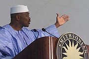
Mali gained independence from France in April 1960, and the Republic of Mali was later established. At this time Bamako had a population of around 160,000. During the 1960s the country became socialist and Bamako was subject to Soviet investment and influence. However, the economy declined as state enterprises collapsed and unrest was widespread. Eventually Moussa Traoré
Moussa Traoré
General Moussa Traoré is a Malian soldier and politician. As a Lieutenant, he led the military ouster of President Modibo Keïta in 1968. Thereafter he served as Head of State from 1968-1979, and President of Mali from 1979 to 1991, when he was overthrown by popular protests and military coup...
led a successful coup and ruled Mali 23 years. However his rule was characterised by severe droughts and poor government management and problems of food shortages.
National Congress for Democratic Initiative
The National Congress for Democratic Initiative is a political party in Mali, founded in 1990 and led by Mountaga Tall.In the first presidential election following the transition to democracy , Mountaga Tali received 11.41% of votes and placed third.In 1995, a group of militants led by Tiébilé...
(Congrès National d'Initiative démocratique, CNID) was set up by the lawyer Mountaga Tall
Mountaga Tall
Mountaga Tall is a Malian politician. He is the President of the National Congress for Democratic Initiative and a Deputy in the National Assembly of Mali; he has also served as a member of the Pan-African Parliament....
, and the Alliance for Democracy in Mali
Alliance for Democracy in Mali
The Alliance for Democracy in Mali-Pan-African Party for Liberty, Solidarity and Justice is a political party in Mali....
(Alliance pour la démocratie au Mali, ADEMA) by Abdramane Baba and historian Alpha Oumar Konaré
Alpha Oumar Konaré
Alpha Oumar Konaré was the President of Mali for two five-year terms , and was Chairperson of the African Union Commission from 2003 to 2008.-Scholarly career:...
. These with the Association des élèves et étudiants du Mali (AEEM) and the Association Malienne des Droits de l'Homme
Association Malienne des Droits de l'Homme
Association Malienne des Droits de l'Homme is a Malian non-profit human rights non-governmental organization founded in Bamako, Mali on December 11, 1988. As of 2006, its president is Moustapha Cisse....
(AMDH) aimed to oust Moussa Traoré. Under the old constitution, all labor unions had to belong to one confederation, the National Union of Malian Workers (UNTM). When the leadership of the UNTM broke from the government in 1990, the opposition grew. Groups were driven by paycuts and layoffs in the government sector, and the Malian government acceding to pressure from international donors to privatise large swathes of the economy that had remained in public hands even after the overthrow of the socialist government in 1968. Students, even children, played an increasing role in the protest marches in Bamako, and homes and businesses of those associated with the regime were ransacked by crowds.
On 22 March 1991 a large-scale protest march in central Bamako was violently suppressed, with estimates of those killed reaching 300. Four days later a military coup deposed Traoré. The Comité de Transition pour le Salut du Peuple was set up, headed by General Amadou Toumani Touré
Amadou Toumani Touré
Amadou Toumani Touré is the president of Mali. He overthrew a military ruler, Moussa Traoré in 1991, then handed power to civilian authorities the next year...
. Alpha Oumar Konari officially became president on April 26, 1992.
Geography
Escarpment
An escarpment is a steep slope or long cliff that occurs from erosion or faulting and separates two relatively level areas of differing elevations.-Description and variants:...
, being what remains of an extinct volcano. The Presidential Palace and main hospital are located here.
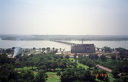
Martyrs Bridge (Bamako)
The Martyrs Bridge of Bamako Mali connects the older sections of the Malian capital to its broad suburbs on the south shore of the Niger River. One of two road bridges across the Niger at Bamako, it is also known as the "Old Bridge". Opened in 1957 when Mali was under French Colonial rule it was...
(2-lane with 2 pedestrian sections) and the King Fahd Bridge
King Fahd Bridge (Bamako)
The King Fahd Bridge of Bamako Mali connects the older sections of the Malian capitol to its broad suburbs on the south shore of the Niger River....
(4-lane with 2 motorcycle and 2 pedestrian sections). Additionally, there is a seasonal causeway between the eastern neighborhoods of Sotuba and Misabugu inherited from colonial times (alternated traffic on 1-lane with 5 crossing sections). The Sotuba Causeway ( "Chaussée submersible de Sotuba" in French, and "Babilikoroni" in Bamanankan
Bambara language
Bambara, more correctly known as Bamanankan , its designation in the language itself , is a language spoken in Mali by as many as six million people...
) is typically under water from July to January. A third bridge (1.4 km long, 24 m large, 4-lane with 2 motorcycle and 2 pedestrian sections) is being built at the same location to reduce downtown congestion, notably by trucks.
Climate
Bamako has a hot and humid Sahelian climate and is very hot on average all year round. Under the Köppen climate classificationKöppen climate classification
The Köppen climate classification is one of the most widely used climate classification systems. It was first published by Crimea German climatologist Wladimir Köppen in 1884, with several later modifications by Köppen himself, notably in 1918 and 1936...
, Bamako has a tropical wet and dry climate. The average temperature highs of every month is over 30 degrees Celsius, with the warmest months being March, April and May where the temperature reaches an average of 39 °C. Record highs of 46 degrees Celsius have been recorded in the month of May. The coolest months are November to February which can experience average lows of 16 to 19 degrees Celsius but the temperature may fluctuate greatly with highs of 47 °C being recorded in February for instance. During the winter rainfall is all very scarce, with little rain from October to April which may lead to drought between December and February. The rainy season occurs in the summer in Bamako with the peak rainfall occurring between July and September.
Administration
Alliance for Democracy in Mali
The Alliance for Democracy in Mali-Pan-African Party for Liberty, Solidarity and Justice is a political party in Mali....
hold the majority of representatives for the communes.
Communes and neighborhoods
Commune I has a population of 256,216 people and covers an area of 34.26 km². It is bounded to the north by the rural commune of Djalakorodji (Kati CercleKati Cercle
Kati Cercle is an administrative subdivision of the Koulikoro Region of Mali. Its seat is the town of Kati, which is also its largest town. It lies at the southwest corner of the region, and completely surrounds the Bamako Capital District...
), west by the Commune II, north-east by the rural commune of Sangarebougou
Sangarebougou
Sangarebougou is a small town and commune in the Cercle of Kati in the Koulikoro Region of south-western Mali. As of 1998 the commune had a population of 13,015....
(Kati Cercle
Kati Cercle
Kati Cercle is an administrative subdivision of the Koulikoro Region of Mali. Its seat is the town of Kati, which is also its largest town. It lies at the southwest corner of the region, and completely surrounds the Bamako Capital District...
), on the east by the rural commune of Gabakourou and south by the Niger River. Nine neighborhoods comprise this commune: Banconi, Boulkassombougou, Djelibougou, Doumanzana Fadjiguila, Sotuba Korofina North and South Korofina Sikoroni.
Commune II has a population of 160,680 people and covers an area of 23 km². It is bounded to the east by the backwater of Korofina at the west foot of the Point G hill, and to the south by Niger River
Niger River
The Niger River is the principal river of western Africa, extending about . Its drainage basin is in area. Its source is in the Guinea Highlands in southeastern Guinea...
. The municipality has eleven neighborhoods: Niaréla (the oldest), Bagadadji, Medina-Coura, Bozola, Missira, Hippodrome, Quinzambougou, Bakaribougou, TSF, Industrial Area and Bougouba. The area is the most important in the industry sector in Bamako.
Commune III has a population of 119,287 people and covers an area of 23 km². It is bounded on the north by the Kati
Kati
Kati is a town made up of 37 communes in Mali's Koulikoro Region, about 15 km from Bamako, Mali's capital. It has a population of approximately 40,000 inhabitants.-Economy:...
, east by the Boulevard du Peuple, which separates it from the Commune II, south by the portion of the Niger River, between the Pont des Martyrs and the Motel de Bamako, and west by the Farako River and Avenue Cheick Zayed El Mahyan Ben Sultan with the neighborhood of ACI-2000. Commune III is the administrative and commercial center of Bamako. It accommodates in particular the two largest markets in the capital, the Grand Market and Didida. Twenty neighborhoods make up this commune and the villages pf Koulouninko and Sirakorodounfing were attached to the Commune III.
Commune IV has a population of 200,000 people (2001) and covers an area of 36.768 km². It is bounded to the east by Commune III, north, west by Kati Cercle and south by the left bank of the Niger River. Commune IV consists of eight neighborhoods: Taliko, Lassa, Sibiribougou, Djikoroni Para, Sébénikoro, Hamdallaye, Lafiabougou and Kalabambougou.
Commune V has a population of 249,727 people and covers an area of 41 km². It is bounded to the north by the Niger River, south by the airport and the town of Coro-Kalanban, and to the east by the Commune VI and Niger. It consists of eight neighborhoods: Badalabougou, Sema I, Quartier Mali, Torokorobougou, Baco-Djicoroni, Sabalibougou, Daoudabougou and Kalaban-Coura.
Commune VI has a population of 600,000 people and covers an area of 88.82 km². This is the largest of the communes that make up Bamako. It consists of ten neighborhoods: Banankabougou, Djanékéla, Faladié, Magnambougou, Missabougou, Niamakoro, Sénou, Sogoniko, Sokorodji and Yrimadio [20].
Bamako contains the following neighborhoods (quartiers): ACI-2000, Badalabugu, Bajalan I, Bajalan II, Bako Jikoroni, Bagadaji, Bamako Kura, Bankoni, Bolibana, Bozola, Bugudani, Bulkasumbugu, Dar Salam, N'tomikorobougou, Dawdabugu, Dravela, Fajigila, Falaje, Garantigibugu, Jalakoroji, Janekela, Janjigila, Jelibugu, Jikoroni Para, Jumanzana, Hamdallaye, Hippodrome
Hippodrome, Bamako
Hippodrome is a Quartier of Bamako, the capital of Mali.Many embassies are located in the Quartier. Furthermore one can find many restaurants, bars, foodstores and hotels in the Quartier. Popular destinations include La Terrasse and Sky Bar. The seat of Geekcorps is also located in the Quartier....
, Kalaban Koro, Kalaban Kura, Korofina, Kuluba, Kulubleni, Lafiabugu, Madina Kura, Magnambugu (Magnambugu Faso Kanu), Misabugu, Misira, Niarela, Ntomikorobugu, Point G, Quartier du Fleuve, Quartier Mali, Quinzanbugu, Sabalibugu I, Sabalibugu II, Safo, Same, Sangarebugu, Saranbugu, Sebeninkoro, Sikoroni, Sirakoro, Senu, Sibiribugu, Sokoniko, Sokoroji, Sotuba, Titibugu, Torokorobugu, TSF-Sans Fil, Wolofobugu, Yirimanjo, Zone Industrielle
Demographics
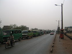
The population growth has been staggering. In 1884 it had only 2500 inhabitants, 8000 in 1908, 37,000 in 1945 and 100,000 in 1960. Today the population is at least 18 times the size of what it was in 1960 with over 1,800,000 recorded at the 2009 Census, and continues to attract a rural population in search of work. Including illegal squatters and temporary workers some experts believe the population today is well over 2 million. This uncontrolled growth causes significant difficulties in terms of traffic, sanitation (access to safe water, sanitation), pollution. Bamako became the crossroads of West Africa and hosts a diverse population, composed of different ethnic groups in Mali but also from neighboring countries.Economy
Industry
The traditional commercial centre of Bamako was located to the north of the river, and contained within a triangle bounded by Avenue du Fleuve, Rue Baba Diarra and Boulevard du Peuple. This area contains the Marché Rose and Street Market.The downtown area is highly congested, polluted, and expensive, and urbanization is sprawling at a rapid pace within a radius of 30 km. The largest urbanized area now lies on the southern bank of the Niger River. A modern Central Business District is rapidly developing immediately west of the downtown area in the ACI-2000 district, taking advantage of a well-designed geometric layout, legacy of the old airport runways and taxiways. A large administrative area is being developed at the junction between ACI-2000 and the King Fadh Bridge, containing most of the state departments (ministries) and administrative services in a central location. Bamako is also the headquarters of many large companies and administrative institutions. Air Mali (formerly Compagnie Aérienne du Mali) has its head office in Bamako. Bamako received much investment by Saudi Arabia
Saudi Arabia
The Kingdom of Saudi Arabia , commonly known in British English as Saudi Arabia and in Arabic as as-Sa‘ūdiyyah , is the largest state in Western Asia by land area, constituting the bulk of the Arabian Peninsula, and the second-largest in the Arab World...
for decades which saw a number of important structures being built. In recent years, China has become an important investor in Bamako, developing its infrastructure and facilities.
Agriculture is active in Bamako, with the presence of Bozo
Bozo
Bozo or bozo may refer to:*The Bozo people, a fishing people of the central Niger delta in Mali*The Bozo languages, languages of the Bozo people*Bozo the Clown, a clown character very popular in the United States...
fisherman and it is common to see cattle crossing the streets. However, the most important by far is the manufacturing and service sector. The District of Bamako concentrates 70% of industrial activity. The service sector is the most developed, and the city thrives in crafts and trade.
Music
A music boom in Bamako took off in the 1990s, when the vocalist Salif KeitaSalif Keita
Salif Keïta is an internationally recognized afro-pop singer-songwriter from Mali. He is unique not only because of his reputation as the Golden Voice of Africa, but because he has albinism and is a direct descendant of the founder of the Mali Empire, Sundiata Keita...
and the singer-guitarist Ali Farka Touré
Ali Farka Touré
Ali Ibrahim “Farka” Touré was a Malian singer and guitarist, and one of the African continent’s most internationally renowned musicians. His music is widely regarded as representing a point of intersection of traditional Malian music and its North American cousin, the blues...
achieved international fame. It attracted a number of tourists, record producers and aspiring musicians to the city to try to follow in their footsteps. It is common to see musicians in the streets with djembe
Djembe
A djembe also known as jembe, jenbe, djbobimbe, jymbe, yembe, or jimbay, or sanbanyi in Susu; is a skin-covered drum meant played with bare hands....
s and percussion bands playing traditional Bamana rhythms.
The range of ethnicities involved in Bamako's music scene are diverse, including singers and instrumentalists from Mali's myriad ethnic groups; the Tuaregs of the Sahara
Sahara
The Sahara is the world's second largest desert, after Antarctica. At over , it covers most of Northern Africa, making it almost as large as Europe or the United States. The Sahara stretches from the Red Sea, including parts of the Mediterranean coasts, to the outskirts of the Atlantic Ocean...
, the Sonrai of Timbuktu
Timbuktu
Timbuktu , formerly also spelled Timbuctoo, is a town in the West African nation of Mali situated north of the River Niger on the southern edge of the Sahara Desert. The town is the capital of the Timbuktu Region, one of the eight administrative regions of Mali...
, the Malinkes from the border region south of Bamako, the Dogon
Dogon people
The Dogon are an ethnic group living in the central plateau region of Mali, south of the Niger bend near the city of Bandiagara in the Mopti region. The population numbers between 400,000 and 800,000 The Dogon are best known for their religious traditions, their mask dances, wooden sculpture and...
cliff dwellers, the Wassalous near the Ivory Coast, the Fula
Fula people
Fula people or Fulani or Fulbe are an ethnic group spread over many countries, predominantly in West Africa, but found also in Central Africa and Sudanese North Africa...
s of central Mali etc. Bars and nightclubs have grown rapidly including Mr. Keita's Mofu and Oumou Sangare
Oumou Sangaré
Oumou Sangare is a Malian Wassoulou musician, sometimes referred to as "The Songbird of Wassoulou." Wassoulou is a historic region south of the Niger River, and the music there is descended from traditional hunting songs, and is accompanied by a calabash...
's Hotel Wassulu which featured Malian and other west African artists. Notable western artists such as Robert Plant
Robert Plant
Robert Anthony Plant, CBE is an English singer and songwriter best known as the vocalist and lyricist of the iconic rock band Led Zeppelin. He has also had a successful solo career...
, Ry Cooder
Ry Cooder
Ryland Peter "Ry" Cooder is an American guitarist, singer and composer. He is known for his slide guitar work, his interest in roots music from the United States, and, more recently, his collaborations with traditional musicians from many countries.His solo work has been eclectic, encompassing...
, Bonnie Raitt
Bonnie Raitt
Bonnie Lynn Raitt is an American blues singer-songwriter and a renowned slide guitar player. During the 1970s, Raitt released a series of acclaimed roots-influenced albums which incorporated elements of blues, rock, folk and country, but she is perhaps best known for her more commercially...
, John Lee Hooker
John Lee Hooker
John Lee Hooker was an American blues singer-songwriter and guitarist.Hooker began his life as the son of a sharecropper, William Hooker, and rose to prominence performing his own unique style of what was originally closest to Delta blues. He developed a 'talking blues' style that was his trademark...
and the French Basque star Manu Chao
Manu Chao
Manu Chao , is a French singer of Spanish roots . He sings in French, Spanish, English, Italian, Galician, Arabic and Portuguese and occasionally in other languages...
have all visited Bamako to jam and record with notable local musicians.
Energy
Much of the electricity, is generated from the hydroelectric Sélingué DamSelingue Dam
The Sélingué Dam is a single purpose hydroelectric dam located in the Koulikoro Region, on the Sankarani River, one of the affluents of the Niger River...
.The drinking water supply in Bamako and Kati
Kati
Kati is a town made up of 37 communes in Mali's Koulikoro Region, about 15 km from Bamako, Mali's capital. It has a population of approximately 40,000 inhabitants.-Economy:...
is also ensured by a pumping station on the Niger River. However, the capacity of 135,000 m³ to provide drinking water per day is insufficient for the needs estimated at 152,000 m³ during the hot season between April and June. During this period, frequent water shortages are experienced. A new pumping station is to open to Kabala
Kabala
Kabala can refer to:*Kabbalah, system of Jewish mysticism*Kabala, Sierra Leone, town in Sierra Leone*Kabala, Estonia, village in Türi Parish, Järva County, Estonia*Kabala, Mardin a town in Mardin Province of Turkey*Ka-Bala, 1967 fortune telling board game...
in 2009.
Landmarks
National Library of Mali
The National Library of Mali is a public library located in Bamako, Mali.The National Library was first created by the Institut Français d’Afrique Noire, an arm of the French colonial government, in 1944. Following Mali's 1960 independence, this library became the Government Library; it would...
was first created by the Institut Français d'Afrique Noire, an arm of the French colonial government, in 1944. Following Mali's 1960 independence, this library became the Government Library; it would later be renamed again as the National Library of Mali. In 1968 the library was transferred from its initial home in Koulouba to Ouolofobougou, a section of Bamako. The library holds more than 60,000 works, including books, periodicals, audio documents, videos, and software. These materials are available free to the public, though a small subscription fee is required for borrowing privileges. The library also hosts some of the exhibits for African Photography Encounters
African Photography Encounters
African Photography Encounters is a biennial exhibition in Bamako, Mali since 1994. The exhibition, featuring exhibits by contemporary African photographers, is spread over several Bamako cultural centers, including the National Museum, the National Library, the Modibo Keïta memorial, and the...
, a biannual Bamako photography festival.
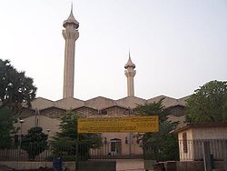
The Bamako Grand Mosque
Bamako Grand Mosque
Bamako Grand Mosque is a mosque in the city centre of Bamako, Mali. Built on the site of a pre-colonial mud-brick mosque, the current Mosque was built through funding from the Saudi Arabian government at the end of the 1970s...
is located in the city centre of Bamako, situated north of the Niger River
Niger River
The Niger River is the principal river of western Africa, extending about . Its drainage basin is in area. Its source is in the Guinea Highlands in southeastern Guinea...
near the central Market (Grand Marche) and the colonial era Bamako Cathedral. It is one of the tallest structures in Bamako. Built on the site of a pre-colonial mud-brick mosque, the current mosque was built through funding from the Saudi Arabian government at the end of the 1970s. With its tall cement minaret
Minaret
A minaret مناره , sometimes مئذنه) is a distinctive architectural feature of Islamic mosques, generally a tall spire with an onion-shaped or conical crown, usually either free standing or taller than any associated support structure. The basic form of a minaret includes a base, shaft, and gallery....
s built around a square central structure, the building is stylistically closer to Saudi religious structures than West African. The mosque is visible from much of the city and occasionally is opened to tourists.
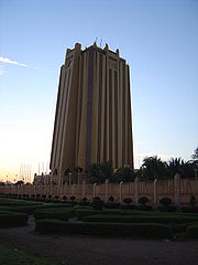
Central Bank of West African States
The Central Bank of West African States is a central bank serving the eight west African countries which comprise the West African Economic and Monetary Union:*Benin*Burkina Faso*Cote d'Ivoire*Guinea Bissau*Mali*Niger*Senegal*Togo-See also:...
, which provides development banking and government financial and currency services in several Francophone
Francophone
The adjective francophone means French-speaking, typically as primary language, whether referring to individuals, groups, or places. Often, the word is used as a noun to describe a natively French-speaking person....
West African nations. Classified as Neo-Sudanic architecture, it is modeled on the Sudano-Sahelian
Sudano-Sahelian
The Sudano-Sahelian covers an umbrella of similar architectural styles common to the Islamized peoples of the Sahel and Sudanian regions of West Africa, south of the Sahara, but above the savanna and fertile forest regions of the coast...
architecture of the famous mosques of Djenne
Djenné
Djenné is an Urban Commune and town in the Inland Niger Delta region of central Mali. In the 2009 census the commune had a population of 32,944. Administratively it is part of the Mopti Region....
and Timbuktu
Timbuktu
Timbuktu , formerly also spelled Timbuctoo, is a town in the West African nation of Mali situated north of the River Niger on the southern edge of the Sahara Desert. The town is the capital of the Timbuktu Region, one of the eight administrative regions of Mali...
. The building is located in the busy Commune III neighbourhood, where "Avenue Moussa Tavele" meets the waterside boulevard between the two main Bamako bridges : King Fahd Bridge
King Fahd Bridge (Bamako)
The King Fahd Bridge of Bamako Mali connects the older sections of the Malian capitol to its broad suburbs on the south shore of the Niger River....
a block west and Martyrs Bridge
Martyrs Bridge (Bamako)
The Martyrs Bridge of Bamako Mali connects the older sections of the Malian capital to its broad suburbs on the south shore of the Niger River. One of two road bridges across the Niger at Bamako, it is also known as the "Old Bridge". Opened in 1957 when Mali was under French Colonial rule it was...
three blocks east. Just to the east of the BCEAO complex, a park and formal garden marks where the diagonally running "Boulevard du Peuple" reaches the river. By contrast, small market gardens and launching points or river canoes lie along the river front. With the Hotel de l'Amitié and the Bamako Grand Mosque
Bamako Grand Mosque
Bamako Grand Mosque is a mosque in the city centre of Bamako, Mali. Built on the site of a pre-colonial mud-brick mosque, the current Mosque was built through funding from the Saudi Arabian government at the end of the 1970s...
, the BCEAO Tower is one of three landmarks visible across most of the city. Also of note is the Bamako Cathedral.
The National Museum of Mali
National Museum of Mali
The National Museum of Malí is an archaeological and anthropological museum located in Bamako, the capital of Mali. It presents permanent and temporary exhibits on the prehistory of Mali, as well as the musical instruments, dress, and ritual objects associated with Mali's various ethnic...
is an archeological and anthropological museum
Museum
A museum is an institution that cares for a collection of artifacts and other objects of scientific, artistic, cultural, or historical importance and makes them available for public viewing through exhibits that may be permanent or temporary. Most large museums are located in major cities...
, presenting permanent and temporary exhibits on the prehistory of Mali, as well as the musical instruments, dress, and ritual objects associated with Mali's various ethnic group
Ethnic group
An ethnic group is a group of people whose members identify with each other, through a common heritage, often consisting of a common language, a common culture and/or an ideology that stresses common ancestry or endogamy...
s. The National Museum began under French rule as the Sudanese Museum, part of the Institut Français d'Afrique Noire (IFAN) under Théodore Monod
Théodore Monod
Théodore André Monod was a French naturalist, explorer, and humanist scholar.-Exploration:...
. It was opened on February 14, 1953, under the direction of Ukrainian
Ukraine
Ukraine is a country in Eastern Europe. It has an area of 603,628 km², making it the second largest contiguous country on the European continent, after Russia...
archeologist Y. Shumowskyi. Archaeologist Y. Shumovskyi had worked in the museum for nine years, gathering half (nearly 3000) of today's finds.
With the independence of the Republic of Mali in 1960, the Sudanese Museum became the National Museum of Mali, with the new objectives of promoting national unity and celebrating Malian traditional culture. However, lack of financial means and absence of qualified personnel caused some deterioration in the museum's collections. On March 30, 1956, the National Museum moved into a new cemented structure, created by architect Jean-Loup Pivin from traditional Malian designs. Since the 1996 election of former archaeologist Alpha Oumar Konaré
Alpha Oumar Konaré
Alpha Oumar Konaré was the President of Mali for two five-year terms , and was Chairperson of the African Union Commission from 2003 to 2008.-Scholarly career:...
to Mali's presidency, the museum's funding has increased considerably, becoming among the best in West Africa
West Africa
West Africa or Western Africa is the westernmost region of the African continent. Geopolitically, the UN definition of Western Africa includes the following 16 countries and an area of approximately 5 million square km:-Flags of West Africa:...
. The museum often hosts part of the biannual African Photography Encounters
African Photography Encounters
African Photography Encounters is a biennial exhibition in Bamako, Mali since 1994. The exhibition, featuring exhibits by contemporary African photographers, is spread over several Bamako cultural centers, including the National Museum, the National Library, the Modibo Keïta memorial, and the...
, photography festival held in Bamako since 1994.
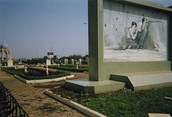
Also of note is the Muso Kunda Museum, the Bamako Regional Museum, Bamako Zoo, the Bamako Botanical Gardens, the National Conference Center Tower (NCC), the Souvenir Pyramid, the Independence Monument, Al Quoods Monument, the triangular Monument de la paix, the Hamdallaye obelisk, the Modibo Keita Memorial and many other monuments, the Palais de la Culture Amadou Hampaté Ba
Palais de la Culture Amadou Hampaté Ba
The Palais de la culture Amadou Hampaté Ba is the national performing arts centre for the West African nation of Mali, located in the capitol Bamako. Founded in 1976, the PCAHB is a public establishment, supported by the state for the preservation of traditional means of artistic expression...
and the Point G hill, containing cave
Cave
A cave or cavern is a natural underground space large enough for a human to enter. The term applies to natural cavities some part of which is in total darkness. The word cave also includes smaller spaces like rock shelters, sea caves, and grottos.Speleology is the science of exploration and study...
s with rock paintings.
In 1988, Bamako was the location of a WHO
World Health Organization
The World Health Organization is a specialized agency of the United Nations that acts as a coordinating authority on international public health. Established on 7 April 1948, with headquarters in Geneva, Switzerland, the agency inherited the mandate and resources of its predecessor, the Health...
conference known as the Bamako Initiative
Bamako Initiative
The Bamako Initiative was a formal statement adopted by African health ministers in 1987 in Bamako, Mali, to implement strategies designed to increase the availability of essential drugs and other healthcare services for Sub-Saharan Africans....
that helped reshape health policy of Sub-Saharan Africa
Sub-Saharan Africa
Sub-Saharan Africa as a geographical term refers to the area of the African continent which lies south of the Sahara. A political definition of Sub-Saharan Africa, instead, covers all African countries which are fully or partially located south of the Sahara...
. The yearly held Budapest-Bamako
Budapest-Bamako
The Budapest-Bamako or Great African Run is now the largest amateur rally in the world, the largest rally across the Sahara and an important charity car race in Africa. The Budapest-Bamako is a low-budget version of the Dakar Rally and goes from Budapest, Hungary to Bamako, Mali through the Sahara...
rally has the endpoint in Bamako, with the Dakar Rally
Dakar Rally
The Dakar Rally is an annual rally raid type of off-road automobile race, organised by the Amaury Sport Organisation...
often passing through Bamako.
Transport
Dakar-Niger Railway
The Dakar–Niger Railway connects Dakar, to Koulikoro, . It serves many cities in Senegal and Mali...
links Bamako to Dakar
Dakar
Dakar is the capital city and largest city of Senegal. It is located on the Cap-Vert Peninsula on the Atlantic coast and is the westernmost city on the African mainland...
via Kati
Kati
Kati is a town made up of 37 communes in Mali's Koulikoro Region, about 15 km from Bamako, Mali's capital. It has a population of approximately 40,000 inhabitants.-Economy:...
, Négala
Negala
Negala is a village in Kohistanat District in Sar-e Pol Province, in northern Afghanistan. It was formerly in Jowzjan Province.It lies just north of Aruj....
, Kita
Kita
-People:* Ikki Kita, Japanese philosopher* Hideki Kita , Japanese long-distance runner.* Michal Kita, Polish mixed martial artist* Kita, the stage name of Sampsa Astala, a member of the Finnish band Lordi...
and Kayes
Kayes
Kayes is a city in western Mali on the Sénégal River, with a population of roughly 100,000 people. Kayes is the capital of the administrative region of the same name. The name "Kayes" comes from the Soninké word "karré", which describes a low humid place that floods in rainy season...
. The road network links Bamako to Koulikoro
Koulikoro
Koulikoro is a city in Mali. The capital of the Koulikoro Region, Koulikoro is located on banks of the Niger River, from Mali's capital Bamako....
, Kati
Kati
Kati is a town made up of 37 communes in Mali's Koulikoro Region, about 15 km from Bamako, Mali's capital. It has a population of approximately 40,000 inhabitants.-Economy:...
, Kolokani
Kolokani
Kolokani is a town of approximately 13,000 inhabitants in Mali's Koulikoro Region.It is the capital of the Cercle of Kolokani, which consists of 10 rural communes . The cercle of Kolokani has an area of 14,380 km² and a population of 163,886 inhabitants....
, Ségou
Ségou
Ségou is a city in south-central Mali, lying northeast of Bamako on the River Niger, in the region of Ségou. It was founded by the Bozo people, on a site about from the present town...
and Sikasso
Sikasso
Sikasso is a city in the south of Mali and the capital of the Sikasso Region. With 130,700 residents, Sikasso recently passed Ségou to become Mali's second-largest city.-Geography:...
.
The Bamako-Sénou International Airport is located 15 km from the city and opened to passengers in 1974. Passenger traffic steadily increased in the early 2000s. Government figures revealed 403,380 passengers in 1999, 423,506 in 2003, 486,526 in 2004, and 516,000 in 2005. and is predicted to reach over 900,000 by 2015 under a low (4%) yearly growth rate scenario. To date this growth rate has been surpassed. Total air traffic the airport increased by 12.4% in 2007 and 14% in 2008. Most of this increase came in passenger transport, with the number of passengers served increasing by 20% in 2007 and 17% in 2008. Twenty-seven airline carriers operated weekly or better at Bamako-Sénou International Airport in the 2007-2008 period. This continued growth was offset by cargo flights' decline of 16.75% in 2007, and 3.93% in 2008. The highest frequency route is on the Bamako-Dakar sector with 29 weekly non-stop connections. Domestic flights also serve Mali's regional capitals Kayes
Kayes
Kayes is a city in western Mali on the Sénégal River, with a population of roughly 100,000 people. Kayes is the capital of the administrative region of the same name. The name "Kayes" comes from the Soninké word "karré", which describes a low humid place that floods in rainy season...
, Mopti
Mopti
Mopti is a city at the confluence of the Niger and the Bani in Mali, between Timbuktu and Ségou. The city lies on three islands linked by dykes: the New Town, the Old Town and Medina Coura. As a result it is sometimes known as the "Venice of Mali".-History:The city of Mopti derives its name from...
, Timbuktu
Timbuktu
Timbuktu , formerly also spelled Timbuctoo, is a town in the West African nation of Mali situated north of the River Niger on the southern edge of the Sahara Desert. The town is the capital of the Timbuktu Region, one of the eight administrative regions of Mali...
, Sikasso
Sikasso
Sikasso is a city in the south of Mali and the capital of the Sikasso Region. With 130,700 residents, Sikasso recently passed Ségou to become Mali's second-largest city.-Geography:...
, Gao
Gao
Gao is a town in eastern Mali on the River Niger lying ESE of Timbuktu. Situated on the left bank of the river at the junction with the Tilemsi valley, it is the capital of the Gao Region and had a population of 86,663 in 2009....
, and Kidal. Bamako Senou International Airport is managed by Aéroports du Mali (ADM). Its operations are overseen by the Malian Ministry of Equipment and Transports.
Much of the transportation is either by the Niger River, or by paved roads linking Bamako to other major urban areas. Navigating the Niger River is possible from Koulikoro to Mopti
Mopti
Mopti is a city at the confluence of the Niger and the Bani in Mali, between Timbuktu and Ségou. The city lies on three islands linked by dykes: the New Town, the Old Town and Medina Coura. As a result it is sometimes known as the "Venice of Mali".-History:The city of Mopti derives its name from...
and Gao
Gao
Gao is a town in eastern Mali on the River Niger lying ESE of Timbuktu. Situated on the left bank of the river at the junction with the Tilemsi valley, it is the capital of the Gao Region and had a population of 86,663 in 2009....
. The bush taxi is one of the main modes of transport.
Bamako is situated on both sides of the river Niger River and two bridges connect the two banks: the Bridge of Martyrs completed in 1960 and renamed in memory of protesters killed in March 1991 by the regime of Moussa Traoré
Moussa Traoré
General Moussa Traoré is a Malian soldier and politician. As a Lieutenant, he led the military ouster of President Modibo Keïta in 1968. Thereafter he served as Head of State from 1968-1979, and President of Mali from 1979 to 1991, when he was overthrown by popular protests and military coup...
, and the King Fahd Bridge
King Fahd Bridge (Bamako)
The King Fahd Bridge of Bamako Mali connects the older sections of the Malian capitol to its broad suburbs on the south shore of the Niger River....
, named after the Saudi Arabian donor. A third bridge project is currently being funded by the People's Republic of China
People's Republic of China
China , officially the People's Republic of China , is the most populous country in the world, with over 1.3 billion citizens. Located in East Asia, the country covers approximately 9.6 million square kilometres...
. Located in Sotuba area, it has the objective to decongest traffic in the city.
Healthcare
The Point G hospital, built between 1906 and 1913, covers an area of 25 hectares. A former military hospital, it became a civilian hospital shortly before the independence of Mali, and is situated on a hill overlooking BamakoThe second hospital of Bamako is the Gabriel Touré Hospital named after a young doctor and humanist Gabriel Touré who was born in 1910 in Ouagadougou
Ouagadougou
Ouagadougou is the capital of Burkina Faso and the administrative, communications, cultural and economic center of the nation. It is also the country's largest city, with a population of 1,475,223 . The city's name is often shortened to Ouaga. The inhabitants are called ouagalais...
and died in 1935 after having been contaminated by a patient with the pneumonic plague
Pneumonic plague
Pneumonic plague, a severe type of lung infection, is one of three main forms of plague, all of which are caused by the bacterium Yersinia pestis. It is more virulent and rare than bubonic plague...
. The hospital was established in 1959.
The contract for the building of a new hospital in Bamako, to relieve pressure on the other hospital resources was signed on December 27, 2008. Located in the district of Yirimadio, the department will include a pediatric and obstetrics-gynecology facilities, a department of internal medicine, medical imagery facilities and hospital care with 150 beds to support the emergency services and intensive care. This hospital, like many recent developments in Bamako is financed and equipped with Chinese investment.
In popular culture
Bamako has provided the backdrop or been the subject of books and films such as BamakoBamako (film)
Bamako is a 2006 film directed by Abderrahmane Sissako, first released at the 2006 Cannes Film Festival on May 21 and in Manhattan by New Yorker Films on February 14, 2007....
, directed by Abderrahmane Sissako
Abderrahmane Sissako
Abderrahmane Sissako is an award-winning film director and producer who has often worked in Mali and France. Sissako is, along with Ousmane Sembène, Souleymane Cissé, Idrissa Ouedraogo and Djibril Diop Mambety, one of the few filmmakers from Sub-Saharan Africa to reach a measure of international...
. The film depicts a trial taking place in Bamako, amid the daily life that is going on in the city. In the midst of that trial, two sides argue whether the World Bank
World Bank
The World Bank is an international financial institution that provides loans to developing countries for capital programmes.The World Bank's official goal is the reduction of poverty...
and International Monetary Fund
International Monetary Fund
The International Monetary Fund is an organization of 187 countries, working to foster global monetary cooperation, secure financial stability, facilitate international trade, promote high employment and sustainable economic growth, and reduce poverty around the world...
, or perhaps corruption, are guilty of the current financial state of many poverty-stricken African countries. The film was first released at the Cannes Film Festival on May 21, 2006 and in Manhattan
Manhattan
Manhattan is the oldest and the most densely populated of the five boroughs of New York City. Located primarily on the island of Manhattan at the mouth of the Hudson River, the boundaries of the borough are identical to those of New York County, an original county of the state of New York...
by New Yorker Films
New Yorker Films
New Yorker Films is an independent film distribution company founded by Daniel Talbot in 1965. It started as an extension of his Manhattan movie house, the New Yorker Theater, after he discovered he was unable to obtain certain foreign titles for exhibition....
on February 14, 2007 and was the recipient of the first Film Award of the Council of Europe given at the Istanbul International Film Festival
Istanbul International Film Festival
The Istanbul International Film Festival is the first and oldest international film festival in Turkey, organised by the Istanbul Foundation for Culture and Arts , a non-profit organisation. It is held every year in April in movie theaters in Istanbul, Turkey...
in April 2007
2007 in film
This is a list of major films released in 2007.-Top grossing films:Please note that following the tradition of the English-language film industry, these are the top grossing films that were first released in the USA in 2007...
.
Notable people
- Adama CoulibalyAdama CoulibalyAdama Coulibaly is a Malian football defender. He was born in Bamako, Mali, and began his career in his local club, Djoliba AC. Coulibaly recently transferred to AJ Auxerre after spending a decade with his former club RC Lens. The transfer fee was priced at 2 million euros...
- Idrissa CoulibalyIdrissa CoulibalyIdrissa Coulibaly is a Malian football player. He currently plays as a defender for Espérance Sportive de Tunis.-Club career:...
- Jean-Charles DeiJean-Charles DeiJean-Charles Dei is a Malian official working for the United Nations' World Food Programme.After assignments in Guinea, the Democratic Republic of the Congo, and Chad, he was appointed in 2005 as WFP director in Central African Republic, amidst a humanitarian crisis that threatened the lives of...
- Massa Makan DiabatéMassa Makan DiabatéMassa Makan Diabaté was a Malian historian, author, and playwright.-Biography:Born in 1938 in Kita, Massa Makan Diabaté was the descendant of a long line of West African poets ....
- Drissa DiakiteDrissa DiakiteDrissa Diakite is a Malian football player who, is playing for OGC Nice.-Career:He has previously played for Djoliba AC and MC Alger ....
- Mahamadou DiarraMahamadou DiarraMahamadou Diarra is a Malian footballer who plays as a defensive midfielder for Mali national team. He is captain of the national team.-Early career:Diarra started his career with Greek side OFI Crete...
- Drissa DiarraDrissa DiarraDrissa Diarra is a Malian football player. He currently plays as a defender for Bellinzona, on loan from Lecce.He player for the Mali national football team at the 2001 FIFA U-17 World Championship and the 2003 FIFA World Youth Championship.-External...
- Moké DiarraMoké DiarraAbdichi-Moké Diarra is a football Midfielder from Mali who is currently playing for SO Cassis Carnoux.- External links :*...
- Lamine DiawaraLamine DiawaraLamine Diawara is a Malian basketball player with Al Ittihad Aleppo in Syria. A member of the Mali national basketball team, Diawara was both the import player of the year and player of the year in 2005-06 in Syria. Prior to playing in Syria, Diawara played with Anibal Zahle in the Lebanese...
- Nare DiawaraNare DiawaraNare Diawara is a Malian professional women's basketball center with the WNBA's San Antonio Silver Stars. Diawara was drafted in the third round of the 2007 WNBA Draft. She played collegiately at Virginia Tech, US....
- Yaya DissaYaya DissaYaya Mamadou Dissa is a Malian international footballer who last played for Division d'Honneur side Niort Saint-Florent.-Career:...
- Adama DraboAdama DraboAdama Drabo was a Malian filmmaker and playwright.- Biography :Adama Drabo showed an interest in film since his childhood in the Malian capital of Bamako...
- Amara Morikè KalléAmara Morikè KalléAmara Dit Morikè Kallé is a Malian football defender, who plays for AJ Auxerre.- Career :Kallé began his career with AS Real Bamako and was in July 2008 transferred to AJ Auxerre.-International career:...
- Ibrahim KanteIbrahim KanteIbrahim Kante is a Malian soccer player, currently a member of the Omaha Vipers, a MISL team.-Career:...
- Salif Keita (footballer)Salif Keita (footballer)Salif Keïta Traoré , known as Keita, is a retired Malian footballer who played as a striker.-Club career:In his country, Keita played for AS Real Bamako and Stade Malien...
- Amadou KonteAmadou KonteAmadou Konte is a Malian-French footballer currently contracted with Bitonto.- Career :Konte started his career in the football academy of French side RC Strasbourg before moving to Portuguese giants FC Porto...
- Seydou Badian KouyatéSeydou Badian Kouyaté-Life:Born in Bamako, Kouyaté studied medicine at the University of Montpellier in France before returning to Mali. Under president Modibo Keïta, he wrote the words for Mali's national anthem, Pour l'Afrique et pour toi, Mali...
- Hamchétou MaïgaHamchétou MaïgaHamchétou Maïga-Ba is a Malian professional women's basketball player most recently with the Minnesota Lynx of the WNBA. She is also a member of the Mali women's national basketball team.-At Old Dominion:...
- Amadou SidibéAmadou SidibéAmadou Sidibé is a Malian football defender. He was born in Bamako, Mali, and began his career in his local club, Cercle Olympique de Bamako, recently transferred to AJ Auxerre from Djoliba Athletic Club.-Trivia:...
- Jean TiganaJean TiganaJean Amadou Tigana is a manager and former French international footballer, having played in midfield and managed professional football extensively throughout France, including 52 appearances and 1 goal for the France national football team during the 1980s.-Playing career:Tigana started his...
- Meiya TireiraMeiya TireiraMeiya Tireira is a Malian women's basketball player. A member of the Mali women's national basketball team, Tireira competed in all 5 of Mali's matches at the 2008 Summer Olympics, scoring a total of 16 points and grabbing 19 rebounds.-References:...
- Sidi TouréSidi TouréSidi Touré is a singer/songwriter from Bamako, Mali. His music is a type of songhaï blues. He started his career in the Sonhaï Stars, a regional orchestra. In 1984 he won the award of best singer with a song of his own hand at a Mali National Bienale. He won the same prize again in 1986...
Sister cities
AngersAngers
Angers is the main city in the Maine-et-Loire department in western France about south-west of Paris. Angers is located in the French region known by its pre-revolutionary, provincial name, Anjou, and its inhabitants are called Angevins....
, France (since 1974) Bobo Dioulasso, Burkina Faso
Burkina Faso
Burkina Faso – also known by its short-form name Burkina – is a landlocked country in west Africa. It is surrounded by six countries: Mali to the north, Niger to the east, Benin to the southeast, Togo and Ghana to the south, and Côte d'Ivoire to the southwest.Its size is with an estimated...
Dakar
Dakar
Dakar is the capital city and largest city of Senegal. It is located on the Cap-Vert Peninsula on the Atlantic coast and is the westernmost city on the African mainland...
, Senegal
Senegal
Senegal , officially the Republic of Senegal , is a country in western Africa. It owes its name to the Sénégal River that borders it to the east and north...
Leipzig
Leipzig
Leipzig Leipzig has always been a trade city, situated during the time of the Holy Roman Empire at the intersection of the Via Regia and Via Imperii, two important trade routes. At one time, Leipzig was one of the major European centres of learning and culture in fields such as music and publishing...
, Germany Rochester, New York
Rochester, New York
Rochester is a city in Monroe County, New York, south of Lake Ontario in the United States. Known as The World's Image Centre, it was also once known as The Flour City, and more recently as The Flower City...
United States (since 1975) São Paulo
São Paulo
São Paulo is the largest city in Brazil, the largest city in the southern hemisphere and South America, and the world's seventh largest city by population. The metropolis is anchor to the São Paulo metropolitan area, ranked as the second-most populous metropolitan area in the Americas and among...
, Brazil
Brazil
Brazil , officially the Federative Republic of Brazil , is the largest country in South America. It is the world's fifth largest country, both by geographical area and by population with over 192 million people...
(since 2000)