
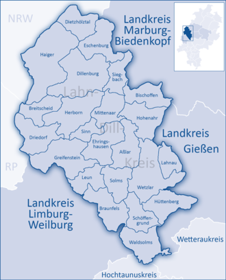
Lahn-Dill-Kreis
Encyclopedia
Lahn-Dill is a Kreis in the west of Hesse
, Germany
. Neighboring districts are Siegen-Wittgenstein
, Marburg-Biedenkopf
, Gießen
, Wetteraukreis
, Hochtaunuskreis
, Limburg-Weilburg
, Westerwaldkreis
.
was merged with the districts Wetzlar
and Dillkreis to the new Lahn-Dill-Kreis. However this big district wasn't popular, so in 1979 Giessen was split from it.
and the Dill
, which also gave it the name. It is mountain landscape with the Westerwald
in the west, the Taunus
in the south, the Lahn-Dill-Bergland in the east and the Rothaargebirge
of the Sauerland
in the north. The highest elevation with 671 m is near Rittershausen (part of Dietzhölztal
), the lowest with 135 is in the Lahn valley in Biskirchen (part of the city Leun
).
Hesse
Hesse or Hessia is both a cultural region of Germany and the name of an individual German state.* The cultural region of Hesse includes both the State of Hesse and the area known as Rhenish Hesse in the neighbouring Rhineland-Palatinate state...
, Germany
Germany
Germany , officially the Federal Republic of Germany , is a federal parliamentary republic in Europe. The country consists of 16 states while the capital and largest city is Berlin. Germany covers an area of 357,021 km2 and has a largely temperate seasonal climate...
. Neighboring districts are Siegen-Wittgenstein
Siegen-Wittgenstein
Siegen-Wittgenstein is a Kreis in the southeast of North Rhine-Westphalia, Germany. Neighboring districts are Olpe, Hochsauerlandkreis, Waldeck-Frankenberg, Marburg-Biedenkopf, Lahn-Dill, Westerwaldkreis, Altenkirchen.-History:...
, Marburg-Biedenkopf
Marburg-Biedenkopf
Marburg-Biedenkopf is a Kreis in the west of Hesse, Germany. Neighboring districts are Waldeck-Frankenberg, Schwalm-Eder, Vogelsbergkreis, Gießen, Lahn-Dill, Siegen-Wittgenstein.- History :...
, Gießen
Gießen (district)
Gießen is a Kreis in the middle of Hessen, Germany. Neighboring districts are Marburg-Biedenkopf, Vogelsbergkreis, Wetteraukreis, Lahn-Dill.-History:...
, Wetteraukreis
Wetteraukreis
The Wetteraukreis is a Kreis in the middle of Hesse, Germany. Neighbouring districts are Landkreis Gießen, Vogelsbergkreis, Main-Kinzig-Kreis, district-free Stadt Frankfurt, Hochtaunuskreis, Lahn-Dill-Kreis.-History:...
, Hochtaunuskreis
Hochtaunuskreis
The Hochtaunuskreis is a Kreis in the middle of Hesse, Germany and is part of the Frankfurt/Rhine-Main Metropolitan Region. Neighbouring districts are Lahn-Dill, Wetteraukreis, district-free Frankfurt, Main-Taunus, Rheingau-Taunus, Limburg-Weilburg.The Hochtaunuskreis and the Landkreis Starnberg...
, Limburg-Weilburg
Limburg-Weilburg
Limburg-Weilburg is a Kreis in the west of Hesse, Germany. Neighboring districts are Lahn-Dill, Hochtaunuskreis, Rheingau-Taunus, Rhein-Lahn, Westerwaldkreis.-History:...
, Westerwaldkreis
Westerwaldkreis
The Westerwaldkreis is a district in the east of Rhineland-Palatinate, Germany...
.
History
In 1977 the district GießenGießen (district)
Gießen is a Kreis in the middle of Hessen, Germany. Neighboring districts are Marburg-Biedenkopf, Vogelsbergkreis, Wetteraukreis, Lahn-Dill.-History:...
was merged with the districts Wetzlar
Wetzlar
Wetzlar is a city in the state of Hesse, Germany. Located at 8° 30′ E, 50° 34′ N, Wetzlar straddles the river Lahn and is on the German Timber-Framework Road which passes mile upon mile of half-timbered houses. Historically, the city has acted as the hub of the Lahn-Dill-Kreis on the north edge of...
and Dillkreis to the new Lahn-Dill-Kreis. However this big district wasn't popular, so in 1979 Giessen was split from it.
Geography
The main rivers of the district are the LahnLahn
The Lahn River is a -long, right tributary of the Rhine River in Germany. Its course passes through the federal states of North Rhine-Westphalia , Hesse , and Rhineland-Palatinate ....
and the Dill
Dill (river)
The Dill is a long river, flowing through central Hesse in Germany. It is a tributary to the Lahn, joining it on the right bank at the town of Wetzlar.-Course:The Dill flows exclusively through the Lahn-Dill-Kreis district in Hesse...
, which also gave it the name. It is mountain landscape with the Westerwald
Westerwald
The Westerwald is a low mountain range on the right bank of the River Rhine in the German federal states of Rhineland-Palatinate, Hesse and North Rhine-Westphalia. It is a part of the Rhine Massif...
in the west, the Taunus
Taunus
The Taunus is a low mountain range in Hesse, Germany that composes part of the Rhenish Slate Mountains. It is bounded by the river valleys of Rhine, Main and Lahn. On the opposite side of the Rhine, the mountains are continued by the Hunsrück...
in the south, the Lahn-Dill-Bergland in the east and the Rothaargebirge
Rothaargebirge
The Rothaargebirge is a low mountain range reaching heights of up to 843.1 m in North Rhine-Westphalia and Hesse, Germany....
of the Sauerland
Sauerland
The Sauerland is a rural, hilly area spreading across most of the south-eastern part of North Rhine-Westphalia, in parts heavily forested and, apart from the major valleys, sparsely inhabited...
in the north. The highest elevation with 671 m is near Rittershausen (part of Dietzhölztal
Dietzhölztal
The community of Dietzhölztal is the northernmost municipality in the Lahn-Dill-Kreis in Hesse, Germany.-Geography:The community is located in a valley of the same name, only a few kilometres east of the border with North Rhine-Westphalia....
), the lowest with 135 is in the Lahn valley in Biskirchen (part of the city Leun
Leun
-Location:Leun lies some 10 km west of Wetzlar between the foothills of the northern Taunus and the Westerwald in the Lahn valley, at a height of 150 to 330 m above sea level.-Neighbouring communities:...
).
Coat of arms
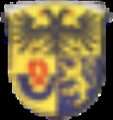
| The coat of arms shows the imperial eagle Imperial Eagle An Imperial Eagle is a heraldic eagle used by an empire, notably:*the military standard of the Roman Empire, see Aquila .*the Byzantine imperial eagle*the German Reichsadler... in the top, a sign for the imperial city Wetzlar. The bottom part - taken from the arms of the previous Dillkreis - shows the lion of Nassau and the horn of the princes of Orange-Nassau House of Orange-Nassau The House of Orange-Nassau , a branch of the European House of Nassau, has played a central role in the political life of the Netherlands — and at times in Europe — since William I of Orange organized the Dutch revolt against Spanish rule, which after the Eighty Years' War... , which later became the Dutch Netherlands The Netherlands is a constituent country of the Kingdom of the Netherlands, located mainly in North-West Europe and with several islands in the Caribbean. Mainland Netherlands borders the North Sea to the north and west, Belgium to the south, and Germany to the east, and shares maritime borders... royal family. Dillenburg Dillenburg Dillenburg is a town in Hesse's Gießen region in Germany. The town was formerly the seat of the old Dillkreis district, which is now part of the Lahn-Dill-Kreis.... was the capital of the county of Nassau and later of Nassau-Orange. |
Towns and municipalities
| Towns | Municipalities | |
|---|---|---|
|
Bischoffen -Location:Bischoffen lies in the Lahn-Dill Highland at the Aar Dam . This dam holds back the river Aar, a tributary to the Dill, forming a 57-ha lake whose purpose is mainly flood control, although of course it also has its recreational uses.... Dietzhölztal The community of Dietzhölztal is the northernmost municipality in the Lahn-Dill-Kreis in Hesse, Germany.-Geography:The community is located in a valley of the same name, only a few kilometres east of the border with North Rhine-Westphalia.... Driedorf -Location:Driedorf lies from 416 to 642 m above sea level on a tableland in the high Westerwald.-Mademühlen:Mademühlen has about 1000 inhabitants and lies in the "Hessischer Westerwald" protected area and in the European protected area network Natura 2000... Ehringshausen -Location:Ehringshausen lies in the valley of the Dill between Wetzlar and Herborn.-Neighbouring communities:Ehringshausen borders in the north on the community of Mittenaar, in the east on the town of Aßlar, in the south on the towns of Solms and Leun, and in the northwest on the community of Sinn... Eschenburg Eschenburg is a community in the Lahn-Dill-Kreis in Hesse, Germany. The community inherited its name from nearby Eschenburg mountain.-Geography:... Greifenstein Greifenstein is a community in the Lahn-Dill-Kreis in Hesse, Germany. Its administrative seat is Beilstein. Greifenstein covers 67.43 km² on the eastern slope of the Westerwald range... Hohenahr -Location:Hohenahr lies in the Lahn-Dill Highland at a height of between 260 and 440 m above sea level. Its constituent communities of Ahrdt and Mudersbach are on the shores of the Aartalsee .-Neighbouring communities:... |
|
External links
- Official website (German)
- Official Online-Community (German)