
Lagunitas Creek
Encyclopedia
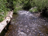
Lagunitas Creek is a stream
in Marin County, California
and is a major supply of drinking water
to the area. The 20-mile (32 km) long creek's headwaters are in the Coast Range
and it flows into the Pacific Ocean
, draining 103 square miles (267 square kilometers).
 The creek's source is the northern slope of Mount Tamalpais
, a few miles (~6–8 km) east of Bolinas Lagoon
. The creek begins as three forks, the East Fork, Middle Fork and West Fork. After about a mile (1,600 m), they all flow into Lake Lagunitas
, which drains into Bon Tempe Lake, which drains into Alpine Lake
. Downstream of Alpine Lake, the creek flows roughly northwest until it reaches Kent Lake
. Just downstream of Kent Lake, San Geronimo Creek
joins the creek. Lagunitas continues northwest through Samuel P. Taylor State Park
and is joined by its largest tributary, Nicasio Creek
, which flows from Nicasio Reservoir
, another water storage reservoir. Shortly after this confluence, Lagunitas turns westward and flows through the town of Point Reyes Station
. On the west side of the town, the creek is joined by Olema Creek and turns northward, emptying into the wetlands at the south end of Tomales Bay
.
Each of the reservoirs in the watershed
has a dam and the biggest problem in the watershed is their blocking of the streams, which prevents fish migration
and dewaters the streambed. Roy's Dam on San Geronimo Creek was built in the 1920s to supply water to a ranch. It was an obstacle for coho salmon
and steelhead
trying access to the habitat
upstream of the dam for spawning
. It was decided to lower the dam instead of completely removing it because of the large amount of sediment
that had accumulated behind the dam. Erosion
is also a significant problem in the watershed.
The Lagunitas Creek Watershed http://www.museumca.org/creeks/1780-RescLagunitas.html is home to the largest-remaining wild run of coho salmon (Oncorhynchus kisutch) in Central California. These coho are part of the "Central California Coast Evolutionarily Significant Unit," or CCC ESU, and are listed as "endangered" at both the state and federal level.
Significant efforts to protect and restore these fish have been underway in the Watershed since the 1980s. Fifty-percent of historical salmon habitat is now behind dams. Strong efforts are also being made to protect and restore undammed, headwater reaches of this Watershed in the San Geronimo Valley, where upwards of 40% of the Lagunitas Creek salmon spawn each year and where as much as 1/3 of the juvenile salmon (or fry) spend their entire freshwater lives. The Salmon Protection and Watershed Network ([1]) leads winter tours for the public to learn about and view these spawning salmon, and also leads year-round opportunities for the public to get involved in stream restoration, monitoring spawning and smolt outmigration, juvenile fish rescue and relocation in the summer, and advocacy and policy development.
Stream
A stream is a body of water with a current, confined within a bed and stream banks. Depending on its locale or certain characteristics, a stream may be referred to as a branch, brook, beck, burn, creek, "crick", gill , kill, lick, rill, river, syke, bayou, rivulet, streamage, wash, run or...
in Marin County, California
Marin County, California
Marin County is a county located in the North San Francisco Bay Area of the U.S. state of California, across the Golden Gate Bridge from San Francisco. As of 2010, the population was 252,409. The county seat is San Rafael and the largest employer is the county government. Marin County is well...
and is a major supply of drinking water
Drinking water
Drinking water or potable water is water pure enough to be consumed or used with low risk of immediate or long term harm. In most developed countries, the water supplied to households, commerce and industry is all of drinking water standard, even though only a very small proportion is actually...
to the area. The 20-mile (32 km) long creek's headwaters are in the Coast Range
Coast Ranges (California)
The Coast Ranges of California constitute one of the eleven traditional geomorphic provinces of California. They include several but not all mountain ranges along the California coast...
and it flows into the Pacific Ocean
Pacific Ocean
The Pacific Ocean is the largest of the Earth's oceanic divisions. It extends from the Arctic in the north to the Southern Ocean in the south, bounded by Asia and Australia in the west, and the Americas in the east.At 165.2 million square kilometres in area, this largest division of the World...
, draining 103 square miles (267 square kilometers).
Mount Tamalpais
Mount Tamalpais is a peak in Marin County, California, United States, often considered symbolic of Marin County. Much of Mount Tamalpais is protected within public lands such as Mount Tamalpais State Park and the Mount Tamalpais Watershed.-Geography:...
, a few miles (~6–8 km) east of Bolinas Lagoon
Bolinas Lagoon
Bolinas Lagoon is a tidal estuary, approximately in area, located at in the West Marin region of Marin County, California, United States. It is a part of the Gulf of the Farallones National Marine Sanctuary. The lagoon is a back bay of Bolinas Bay on the Pacific coast approximately 15 mi ...
. The creek begins as three forks, the East Fork, Middle Fork and West Fork. After about a mile (1,600 m), they all flow into Lake Lagunitas
Lake Lagunitas
Lake Lagunitas is a reservoir on Lagunitas Creek in Marin County, California.It is one of seven reservoirs providing potable water to the Marin Municipal Water District. Built in 1873, it is the oldest and smallest lake in the Mount Tamalpais watershed....
, which drains into Bon Tempe Lake, which drains into Alpine Lake
Alpine Lake
Alpine Lake is a reservoir in Marin County, California. Formed by Alpine Dam, it provides water to the Marin Municipal Water District. Below the dam lies Kent Lake.-See also:*Lake Alpine*List of lakes in California...
. Downstream of Alpine Lake, the creek flows roughly northwest until it reaches Kent Lake
Kent Lake
Kent Lake is a reservoir in western Marin County, California formed by the construction of Peters Dam across Lagunitas Creek. Built in 1954, the lake is the most recent lake of the Marin Municipal Water District, as well as the largest...
. Just downstream of Kent Lake, San Geronimo Creek
San Geronimo Creek
San Geronimo Creek is a stream in Marin County, California, United States, which feeds into Lagunitas Creek below Kent Lake.-Course:The creek rises in the hills west of the town of Lucas Valley...
joins the creek. Lagunitas continues northwest through Samuel P. Taylor State Park
Samuel P. Taylor State Park
Samuel P. Taylor State Park is a state park located in Marin County, California. It contains approximately of redwood and grassland. The park contains about of old-growth forest, some of which can be seen along the Pioneer Tree Trail.-History:...
and is joined by its largest tributary, Nicasio Creek
Nicasio Creek
Nicasio Creek is an stream in Marin County, California, United States which feeds into Lagunitas Creek. The Nicasio Reservoir, formed in 1961 by Seeger Dam, is located on this stream.-Course:...
, which flows from Nicasio Reservoir
Nicasio Reservoir
Nicasio Reservoir is a shallow, man-made reservoir in the Nicasio Valley region of Marin County, California, United States. It covers and sits in a drainage basin. It was created by the construction of Seeger Dam on the Nicasio Creek in 1961...
, another water storage reservoir. Shortly after this confluence, Lagunitas turns westward and flows through the town of Point Reyes Station
Point Reyes Station, California
Point Reyes Station is small unincorporated town located in western Marin County, California. Point Reyes Station is located south-southeast of Tomales, at an elevation of . Point Reyes Station is located along State Route 1 and is a gateway to the Point Reyes National Seashore, an extremely...
. On the west side of the town, the creek is joined by Olema Creek and turns northward, emptying into the wetlands at the south end of Tomales Bay
Tomales Bay
Tomales Bay is a long narrow inlet of the Pacific Ocean in Marin County in northern California in the United States. It is approximately 15 miles long and averages nearly 1.0 miles wide, effectively separating the Point Reyes Peninsula from the mainland of Marin County. It is located...
.
Each of the reservoirs in the watershed
Drainage basin
A drainage basin is an extent or an area of land where surface water from rain and melting snow or ice converges to a single point, usually the exit of the basin, where the waters join another waterbody, such as a river, lake, reservoir, estuary, wetland, sea, or ocean...
has a dam and the biggest problem in the watershed is their blocking of the streams, which prevents fish migration
Fish migration
Many types of fish migrate on a regular basis, on time scales ranging from daily to annually or longer, and over distances ranging from a few metres to thousands of kilometres...
and dewaters the streambed. Roy's Dam on San Geronimo Creek was built in the 1920s to supply water to a ranch. It was an obstacle for coho salmon
Coho salmon
The Coho salmon, Oncorhynchus kisutch, is a species of anadromous fish in the salmon family. Coho salmon are also known as silver salmon or "silvers". It is the state animal of Chiba, Japan.-Description:...
and steelhead
Rainbow trout
The rainbow trout is a species of salmonid native to tributaries of the Pacific Ocean in Asia and North America. The steelhead is a sea run rainbow trout usually returning to freshwater to spawn after 2 to 3 years at sea. In other words, rainbow trout and steelhead trout are the same species....
trying access to the habitat
Habitat (ecology)
A habitat is an ecological or environmental area that is inhabited by a particular species of animal, plant or other type of organism...
upstream of the dam for spawning
Spawn (biology)
Spawn refers to the eggs and sperm released or deposited, usually into water, by aquatic animals. As a verb, spawn refers to the process of releasing the eggs and sperm, also called spawning...
. It was decided to lower the dam instead of completely removing it because of the large amount of sediment
Sediment
Sediment is naturally occurring material that is broken down by processes of weathering and erosion, and is subsequently transported by the action of fluids such as wind, water, or ice, and/or by the force of gravity acting on the particle itself....
that had accumulated behind the dam. Erosion
Erosion
Erosion is when materials are removed from the surface and changed into something else. It only works by hydraulic actions and transport of solids in the natural environment, and leads to the deposition of these materials elsewhere...
is also a significant problem in the watershed.
The Lagunitas Creek Watershed http://www.museumca.org/creeks/1780-RescLagunitas.html is home to the largest-remaining wild run of coho salmon (Oncorhynchus kisutch) in Central California. These coho are part of the "Central California Coast Evolutionarily Significant Unit," or CCC ESU, and are listed as "endangered" at both the state and federal level.
Significant efforts to protect and restore these fish have been underway in the Watershed since the 1980s. Fifty-percent of historical salmon habitat is now behind dams. Strong efforts are also being made to protect and restore undammed, headwater reaches of this Watershed in the San Geronimo Valley, where upwards of 40% of the Lagunitas Creek salmon spawn each year and where as much as 1/3 of the juvenile salmon (or fry) spend their entire freshwater lives. The Salmon Protection and Watershed Network ([1]) leads winter tours for the public to learn about and view these spawning salmon, and also leads year-round opportunities for the public to get involved in stream restoration, monitoring spawning and smolt outmigration, juvenile fish rescue and relocation in the summer, and advocacy and policy development.