
Laguna Miscanti
Encyclopedia
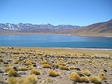
Laguna Miscanti is a brackish water
lake
located in the altiplano
of the Antofagasta Region
, in northern Chile
. Miñiques
volcano and Cerro Miscanti
tower over this lake. This heart-shaped lake has a deep blue color. The western shoreline of the lake is separated by less than 1 km from the drainage divide between the lake and the Salar de Atacama
basins. Laguna Miscanti basin also has a common boundary with Salar de Talar
basin.
A lava flow from an eruption of Miñiques separated Laguna Miscanti from Laguna Miñiques.
The lake is part of one of the seven sectors of Los Flamencos National Reserve
.
Brackish water
Brackish water is water that has more salinity than fresh water, but not as much as seawater. It may result from mixing of seawater with fresh water, as in estuaries, or it may occur in brackish fossil aquifers. The word comes from the Middle Dutch root "brak," meaning "salty"...
lake
Lake
A lake is a body of relatively still fresh or salt water of considerable size, localized in a basin, that is surrounded by land. Lakes are inland and not part of the ocean and therefore are distinct from lagoons, and are larger and deeper than ponds. Lakes can be contrasted with rivers or streams,...
located in the altiplano
Altiplano
The Altiplano , in west-central South America, where the Andes are at their widest, is the most extensive area of high plateau on Earth outside of Tibet...
of the Antofagasta Region
Antofagasta Region
The II Antofagasta Region is one of Chile's fifteen first-order administrative divisions. It comprises three provinces, Antofagasta, El Loa and Tocopilla...
, in northern Chile
Chile
Chile ,officially the Republic of Chile , is a country in South America occupying a long, narrow coastal strip between the Andes mountains to the east and the Pacific Ocean to the west. It borders Peru to the north, Bolivia to the northeast, Argentina to the east, and the Drake Passage in the far...
. Miñiques
Miñiques
Miñiques is a massive volcanic complex containing a large number of craters, lava domes and flows, located in the Antofagasta Region of Chile. Located south of Volcán Chiliques and west of Cordón Puntas Negras, it is part of a frequently visited attraction conformed by the high plain lagoons...
volcano and Cerro Miscanti
Cerro Miscanti
Cerro Miscanti is a mountain located in the Antofagasta Region of Chile, immediately south of Chiliques and north of Miñiques. It towers over Laguna Miscanti.-See also:* Miñiques* Chiliques* Laguna Miscanti* Cordón Puntas Negras...
tower over this lake. This heart-shaped lake has a deep blue color. The western shoreline of the lake is separated by less than 1 km from the drainage divide between the lake and the Salar de Atacama
Salar de Atacama
Salar de Atacama is the largest salt flat in Chile. It is located south of San Pedro de Atacama, is surrounded by mountains and has no drainage outlets. To the east is enclosed by the main chain of the Andes, while to the west lies a secondary mountain range of the Andes called Cordillera de Domeyko...
basins. Laguna Miscanti basin also has a common boundary with Salar de Talar
Salar de Talar
Salar de Talar is a 46 square kilometres salt flat located in the high puna of northern Chilean Andes, at an altitude of 3,950 m. It is part of a series of salt lakes and salt flats located at the foothills of a chain of volcanoes stretching along the eastern side of the much greater Salar de...
basin.
A lava flow from an eruption of Miñiques separated Laguna Miscanti from Laguna Miñiques.
The lake is part of one of the seven sectors of Los Flamencos National Reserve
Los Flamencos National Reserve
Los Flamencos National Reserve is a nature reserve located in the commune of San Pedro de Atacama, Antofagasta Region of Chile. The reserve covers a total area of in the Central Andean dry puna ecoregion and consists of seven separate sectors....
.