

La Conchita, California
Encyclopedia
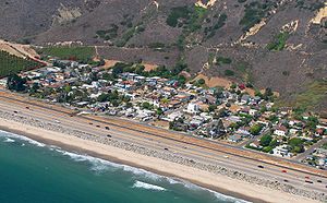
La Conchita is a small unincorporated community in western Ventura County, California
, on U.S. Route 101
just southeast of the Santa Barbara
county line. The ZIP Code is 93001, and the community is inside area code 805
.
 "La Conchita", Spanish for little conch shell, was first used as the name of a spur on the Southern Pacific
railroad line in the 1880s and it was a name generally used to describe a broader area than the present day village. During this time until 1923, the small beach settlement was named "Punta" and the street names still carried today (San Fernando
, Ojai, Bakersfield, Carpinteria, etc.) commemorated the home town areas of the railroad workers who settled in the town while building the Southern Pacific line. The name change and designated area then known as La Conchita are crucially important to any understanding of the region today and its geologic history. Up through the 1930s as historically documented, the area from Bates Road down to Mussel Shoals (then known as Mussel Rock) was referred to as La Conchita.
This fact has led to much misrepresentation of the landslide history of the village now known as La Conchita. In fact, prior to the 1995 landslide, there have been no documented landslides in the present day La Conchita community. All of the prior landslide activity, including the infamous 1909 landslide, took place north of the present day village. A careful study of the photographs of these historic landslides provides proof of this beyond any doubt.
What is now the community of La Conchita was originally part of the 4460 acres (18 km²) Mexican land grant
Rancho El Rincon
given by Governor José Figueroa
to Teodoro Arrellanes in 1835. Arrellanes’ daughter Maria married Dr. Matthew Biggs, and the property was transferred to Biggs in 1855. During the 1860s following a long period of drought, the record rainfall of 1868 produced major flooding throughout the county. It was during this time that major portions of the old ranchos were subdivided and sold off by heirs to an increasing number of arriving Anglos.
The Homestead Act
of 1862 had brought many adventurous newcomers to settle in California. Levi Gould Stanchfield, born in Leeds, Maine in 1841, established a ranch at Punta Gorda in 1875 where he raised sheep, grew lima beans and built a ranch house at Mussel Rock. Stanchfield was married to Luisa Arenas. Her father, Luis Arenas, held several land grants, and in 1838 was Mayor of Los Angeles. Her mother Josepfa Palomares was the sister of Ygnacio Palomares one of the first settlers of the San Gabriel Valley. Stanchfield sold the property to Charles. E. Ablett in 1879. Ablett, born in England, was well known as a druggist in Santa Barbara and a key figure in the homesteading activity of the Punta Gorda area from the 1880s on. At this time, the La Conchita section of the Southern Pacific railroad was almost completed and the village of Punta was established. Among the founding families of Punta were the Callis from Kentucky; the Mullins from Charlottetown, Prince Edward Island, Canada; and the Gaynors from Ireland. Members of these families were prominent in local history for the next sixty years.
From 1880-1916 a U.S. post office was sited in Punta, and Punta Gorda served as a stop for both the stagecoach and the railroad. Charles E. Ablett served as the first postmaster. In 1883 the Rincon School district was established and classes were first held in the home of Robert Callis with nine pupils in attendance. The 1883 census listed 17 children living in Punta. In 1890 the name was changed to the Punta Gorda School District, and the first school structure was built in the village. The Ventura County Register of 1890, as well as the Rincon district electoral records from 1900–1916, reflects a rich cultural mix of Anglo and Hispanic residents in Punta and the Rincon area.
A right of way was granted to the Southern Pacific railroad in 1887 and narrow ledges were blasted for the tracks. Since there was no room for a wagon road after that, the idea of building a series of wooden causeway around the cliffs was first developed in 1910. The idea was taken from the European models that existed at the time in Monte Carlo. The "causeway," a timber pile trestle with a 16’ wide roadway, was a cooperative project between Santa Barbara and Ventura Counties. By 1912, Rincon Road became part of the state highway system. In 1926, it was replaced with cement concrete pavement.
Farming remained the predominant occupation of the area through the First World War. It was a precarious way of life, since there was little fresh water available. During the severe drought of 1898 news accounts detailed the record number of livestock being driven north to pasture and to early market as well as the constant drilling efforts for sources of artesian water to ease the plight of the farmers.
Successful oil drilling, however was a different matter. Oil leasing, which started in the area as early as the 1850s, became increasingly important. The Punta Gorda Land & Oil Company was established in 1900. The Rincon Oil Field
, adjacent to the town on the south, was discovered in 1927.
Robert Bates and Andrew Bailard purchased land in La Conchita in hopes of finding oil in the area. (Andrew Bailard had purchased 500 acres (2 km²) of land in Carpinteria in 1868). This enterprise was to fail financially. As noted in the memoirs of Edward Bates, from 1910 until the late 1920s the beach area of the Rincon was viewed as more of a liability than an asset. Unsuccessful drilling for water also began in earnest at this time.
Edward C. Ramelli, bought land that had a resort hotel called the Mussel Rock Inn and property in La Conchita at the water's edge in 1923. His brother Milton was a civil engineer and surveyor. He laid out the first nineteen homes and called it La Conchita del Mar. The following May, Milton Ramelli laid out 327 more lots on a dozen 40 feet (12.2 m) streets on the uphill side of the railroad tracks. La Conchita del Mar was promoted as an affordable seaside paradise with lots available starting at $200, which included oil rights. It was called a "beach with a future." Milton Ramelli also subdivided the 66-lot community of Mussel Shoals in 1924 on land owned by the Hickey Brothers. Ten years later he also developed Solimar Beach on leased land.
For many years La Conchita remained a small and quiet community. Many people who had purchased property here initially built summer homes right on the beach, drawn to the serenity and the unspoiled beauty of the beach, ocean and the view.
The La Conchita Story project used oral histories and memories of a residents of the community from 1928 on. Eleanor Gallardo Ramey was born in La Conchita in 1928 in the house built by her father Joseph Gallardo a year earlier. The Gallardo homestead still stands on Sunland Avenue, which was then known as Ventura Avenue. Joseph Gallardo, a native of Mexico, worked for the railroad as a watchman and Eleanor has vivid memories, as well as photographs, of all the years she attended the Punta Gorda (one room) Schoolhouse in La Conchita. Pete Richardson came to La Conchita in 1928 when he was two years old. His father Harry Richardson was an oil worker who dug the first oil well in Mussel Shoals (then known as Mussel Rock). At that time, Richardson remembers his family as having the only "real house in La Conchita", an adobe, whose foundation can still be found just south of town. Dick Talaugon's father Federico Talaugon leased a large house from the Gaynor family on the site of the current Phillips oil storage facility. The family moved there in the winter of 1932 and were part of a growing Pacific Islander community working the farms and ranches of the major landowners of the region. Here Talaugon farmed lima beans and barley. Both Pete Richardson and Dick Talaugon attended Punta Gorda School, the one-room schoolhouse in La Conchita. The school was moved in the mid 1950s to Santa Clara Street in Ventura and used as a kindergarten. Prior to demolition of the building, part was salvaged and moved to its present location in La Conchita at 6746 Ojai Street. Remnants of the concrete foundation can still be found just west of town near the avocado orchard across from Carpinteria Street.
By 1930 there were a dozen or so families living in small cottages at the foot of the hill. Lima beans grew on either side of the community and the community sloped down to the shore broken only by the railroad tracks and the old Rincon Highway. For 25¢ per five-gallon jug, the Matilja Water Company delivered water to La Conchita residents.
In 1931 Rudy Scheidman and Frank Regamey purchased the Mussel Rock Inn on the beach side of the railroad track at Mussel Shoals. It once had a glass enclosed dance floor over the water, eventually lost to the winter surf and attracted such Hollywood celebrities as Marie Dressler
, Warner Oland
and opera singer Lotte Lehmann
. When the highway was widened to three lanes in 1935, the restaurant had to be moved to the beach at La Conchita and was renamed as Frank and Rudy's. It closed in 1942.
In 1949 the Highway was widened to four lanes with outer edges of the seawall
protected by a riprap
seawall of boulders weighing up to 10 tons brought by rail from Riverside County.
In the early 1950s the La Conchita cottages on the beach were either relocated or demolished when the highway was widened.
During the 1950s and 1960s La Conchita became a popular vacation destination for many families in the San Fernando Valley
. Mobile homes and small beach cottages started popping up in the small lots, and as the town became more popular, larger custom homes.
In 1956-7, Richland Oil Company constructed an artificial island for oil drilling off Mussel Shoals. The construction of Casitas Dam was completed in 1959 and through its distribution system, running water finally came to La Conchita.
 1967- Phillips Petroleum Company proposed its processing plant on 15 acres (60,702.9 m²) previously zoned for homes.
1971- Highway 101 completed
1975- La Conchita Ranch Co. started to farm the plateau, a marine terrace above the community, for citrus and avocado.
1985- La Conchita banana plantation started
From its opening until its forced closure in 1996, the Seaside Banana Gardens operated by Doug Richardson and his partner Paul Turner, became the most famous attraction in La Conchita. The Gardens were featured in both national and international publications and made La Conchita a landmark along Highway 101. Although horticultural authorities maintained that bananas could not be commercially grown in California, Richardson and Turner proved them wrong by cultivating over 50 exotic varieties. The unique microclimate of the community's location was ideal for this purpose. Many subsequent generations of bananas continue to grow and thrive throughout the home gardens of La Conchita today.
1986- Internationally recognized Artist Roger Brown moves to La Conchita.
Roger Brown (1941–1997) lived primarily in La Conchita from the late 1980s until his untimely death in 1997. The community and its environment inspired many of the artist's paintings during the last decade of his life. Brown was a member of the class-action lawsuit filed against La Conchita Ranch as a result of the 1995 mudslide, and some of his works depict the cataclysmic events of that day rendered in his signature style. His works are in major museums and private collections throughout the country. The artist's estate and collections are maintained at the Roger Brown Study Collection at the School of the Art Institute of Chicago.http://www.artic.edu/saic/art/brown/rbsc/index.html
1992- renowned Chicago architect Stanley Tigerman Architect, (b.1930- ) completes the studio home of artist Roger Brown (1941–1997) on Ojai Street.
The pink adobe home has become a significant landmark in La Conchita. Brown had fought for more than two years to get the design of this studio through the Ventura County Planning Commission and even commemorated his frustrations with the Commission in a now famous painting.
1995- first major mudslide affecting the village of La Conchita.
2004- Roger Brown residence purchased by ER Nurse Bill Harbison. 1.5 months later the 2005 landslide occurred, during which he was responsible for two live rescues, for which he was awarded the Medal of Valor by the Ventura County Fire Department and the State of California.
2005- The 2005 La Conchita Landslide
takes the lives of ten La Conchita residents.
On Jan. 15, 2005 the residents formed the La Conchita Community Organization (LCCO). The LCCO has worked with Local, State and the Federal Government officials to resolve the landslide situation that has affected the community since 1995. In March 2006 Governor Schwarzenegger announced the allocation of $667,000 for a "comprehensive study to examine how to ensure the safety of the beachside community." The contract to the consulting firm was signed in April 2007 and a "draft" report was received at the beginning of 2009.
In 2008 plaintiffs representing family members of those killed and residents who lost property in the 2005 La Conchita mudslide successfully settled a lawsuit filed against the La Conchita Ranch. The Ranch was found partly negligent and settled. The assets of the ranch plus a cash settlement were turned over to the plaintiffs. (See:"Firm to Settle Suit Over Deadly La Conchita Slide "Los Angeles Times,California Section, Sept.9, 2008) among other California papers. The ranch has since been purchased and La Conchita residents are working with the new owners to coordinate the efforts for the future safety of all residents.
The plaintiffs also sued the County of Ventura for damages arising out on the 2005 landlside. Plaintiffs claimed that the a wall that the County built at the base of the landslide caused or contributed to their damages. At trial, the County prevailed against the plaintiffs on all claims. Plaintiffs appealed, but the Court of Appeal ruled in favor of the County. It found that warnings the County gave of the dangers of living in La Conchita were "sufficient to advise any reasonable person to stay away from La Conchita..."
La Conchita is a highly sought after location because of the camaraderie that exists between neighbors, its accessibility to fine surfing
beaches, a Mediterranean-like climate, and spectacular views into the Santa Barbara Channel
.
La Conchita is at 119.448 degrees west longitude and 34.364 degrees north latitude, on a southwesterly-facing portion of the coast. The town is called "Punta" on USGS topographic maps. It is between Rincon Point to the northwest and Mussel Shoals to the southeast; 659 m (2161 ft) Rincon Mountain rises sharply to the northeast. The nearest incorporated town is Carpinteria
, about five miles (8 km) to the northwest.
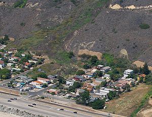
 Sandwiched between a steep, unstable hillside (with the La Conchita Ranch Company situated on the plateau directly over the community), and the Pacific Ocean, La Conchita has been the site of recent major mudslides:
La Conchita Ranch Co. was sued by those affected by the 2005 landslide. A settlement was reached, giving the plaintiffs the company's assets and $5 million dollars.
Ventura County, California
Ventura County is a county in the southern part of the U.S. state of California. It is located on California's Pacific coast. It is often referred to as the Gold Coast, and has a reputation of being one of the safest populated places and one of the most affluent places in the country...
, on U.S. Route 101
U.S. Route 101
U.S. Route 101, or U.S. Highway 101, is an important north–south U.S. highway that runs through the states of California, Oregon, and Washington, on the West Coast of the United States...
just southeast of the Santa Barbara
Santa Barbara County, California
Santa Barbara County is a county located in the southern portion of the U.S. state of California, on the Pacific coast. As of 2010 the county had a population of 423,895. The county seat is Santa Barbara and the largest city is Santa Maria.-History:...
county line. The ZIP Code is 93001, and the community is inside area code 805
Area code 805
North American area code 805 is a California telephone area code. Area code 805 includes most or all of the California counties of San Luis Obispo, Santa Barbara, and Ventura, plus southernmost portions of Monterey County....
.
History
Southern Pacific Railroad
The Southern Pacific Transportation Company , earlier Southern Pacific Railroad and Southern Pacific Company, and usually simply called the Southern Pacific or Espee, was an American railroad....
railroad line in the 1880s and it was a name generally used to describe a broader area than the present day village. During this time until 1923, the small beach settlement was named "Punta" and the street names still carried today (San Fernando
San Fernando, California
San Fernando is a city located in the San Fernando Valley, in northwestern region of Los Angeles, California, United States. The population was 23,645 at the 2010 census, up from 23,564 at the 2000 census.-History:...
, Ojai, Bakersfield, Carpinteria, etc.) commemorated the home town areas of the railroad workers who settled in the town while building the Southern Pacific line. The name change and designated area then known as La Conchita are crucially important to any understanding of the region today and its geologic history. Up through the 1930s as historically documented, the area from Bates Road down to Mussel Shoals (then known as Mussel Rock) was referred to as La Conchita.
This fact has led to much misrepresentation of the landslide history of the village now known as La Conchita. In fact, prior to the 1995 landslide, there have been no documented landslides in the present day La Conchita community. All of the prior landslide activity, including the infamous 1909 landslide, took place north of the present day village. A careful study of the photographs of these historic landslides provides proof of this beyond any doubt.
1817–1912
Prior to the establishment of the village of Punta, the coastal area was named Punta Gorda. "Punta Gorda", Spanish for massive point, referred to the outstanding feature of this coastal area, a large rock promontory. A monk who stopped at the Mission San Buenaventura in 1817 first mentioned the site. The history of the hamlet of La Conchita is closely tied to developments in the Rincon Point area. The name "The Rincon" was also routinely used to designate the area from Carpinteria's Rincon Point to Ventura's Sea Cliff. From 1850 until 1873 when Ventura County was established, Punta Gorda was part of Santa Barbara County.What is now the community of La Conchita was originally part of the 4460 acres (18 km²) Mexican land grant
Ranchos of California
The Spanish, and later the Méxican government encouraged settlement of territory now known as California by the establishment of large land grants called ranchos, from which the English ranch is derived. Devoted to raising cattle and sheep, the owners of the ranchos attempted to pattern themselves...
Rancho El Rincon
Rancho El Rincon (Arellanes)
Rancho El Rincon was a Mexican land grant in present day Santa Barbara County and Ventura County, California given in 1835 by Governor José Figueroa to Teodoro Arellanes. "Rincon" means "corner" in Spanish...
given by Governor José Figueroa
José Figueroa
General José Figueroa , was a General and the Mexican territorial Governor of Alta California from 1833 to 1835.Figueroa oversaw the initial secularization of the missions of upper California, which included the expulsion of the Spanish Franciscan mission officials.This also involved the issuing of...
to Teodoro Arrellanes in 1835. Arrellanes’ daughter Maria married Dr. Matthew Biggs, and the property was transferred to Biggs in 1855. During the 1860s following a long period of drought, the record rainfall of 1868 produced major flooding throughout the county. It was during this time that major portions of the old ranchos were subdivided and sold off by heirs to an increasing number of arriving Anglos.
The Homestead Act
Homestead Act
A homestead act is one of three United States federal laws that gave an applicant freehold title to an area called a "homestead" – typically 160 acres of undeveloped federal land west of the Mississippi River....
of 1862 had brought many adventurous newcomers to settle in California. Levi Gould Stanchfield, born in Leeds, Maine in 1841, established a ranch at Punta Gorda in 1875 where he raised sheep, grew lima beans and built a ranch house at Mussel Rock. Stanchfield was married to Luisa Arenas. Her father, Luis Arenas, held several land grants, and in 1838 was Mayor of Los Angeles. Her mother Josepfa Palomares was the sister of Ygnacio Palomares one of the first settlers of the San Gabriel Valley. Stanchfield sold the property to Charles. E. Ablett in 1879. Ablett, born in England, was well known as a druggist in Santa Barbara and a key figure in the homesteading activity of the Punta Gorda area from the 1880s on. At this time, the La Conchita section of the Southern Pacific railroad was almost completed and the village of Punta was established. Among the founding families of Punta were the Callis from Kentucky; the Mullins from Charlottetown, Prince Edward Island, Canada; and the Gaynors from Ireland. Members of these families were prominent in local history for the next sixty years.
From 1880-1916 a U.S. post office was sited in Punta, and Punta Gorda served as a stop for both the stagecoach and the railroad. Charles E. Ablett served as the first postmaster. In 1883 the Rincon School district was established and classes were first held in the home of Robert Callis with nine pupils in attendance. The 1883 census listed 17 children living in Punta. In 1890 the name was changed to the Punta Gorda School District, and the first school structure was built in the village. The Ventura County Register of 1890, as well as the Rincon district electoral records from 1900–1916, reflects a rich cultural mix of Anglo and Hispanic residents in Punta and the Rincon area.
A right of way was granted to the Southern Pacific railroad in 1887 and narrow ledges were blasted for the tracks. Since there was no room for a wagon road after that, the idea of building a series of wooden causeway around the cliffs was first developed in 1910. The idea was taken from the European models that existed at the time in Monte Carlo. The "causeway," a timber pile trestle with a 16’ wide roadway, was a cooperative project between Santa Barbara and Ventura Counties. By 1912, Rincon Road became part of the state highway system. In 1926, it was replaced with cement concrete pavement.
Farming remained the predominant occupation of the area through the First World War. It was a precarious way of life, since there was little fresh water available. During the severe drought of 1898 news accounts detailed the record number of livestock being driven north to pasture and to early market as well as the constant drilling efforts for sources of artesian water to ease the plight of the farmers.
Successful oil drilling, however was a different matter. Oil leasing, which started in the area as early as the 1850s, became increasingly important. The Punta Gorda Land & Oil Company was established in 1900. The Rincon Oil Field
Rincon Oil Field
The Rincon Oil Field is a large oil field on the coast of southern California, about ten miles northwest of the city of Ventura, and about 20 miles east-southeast of the city of Santa Barbara. It is the westernmost onshore field in a series of three fields which follow the Ventura Anticline, an...
, adjacent to the town on the south, was discovered in 1927.
1913–1926
Dr. C.E. Bates was an English doctor drawn to the California gold rush. He later practiced medicine in Santa Barbara. His son, Robert W. Bates, returned from military service in Europe during World War I and worked the ranch along with his brother Edward. A parcel map of La Conchita was first recorded in the 1920s. At that time it was primarily occupied by workers in the nearby oil fields.Robert Bates and Andrew Bailard purchased land in La Conchita in hopes of finding oil in the area. (Andrew Bailard had purchased 500 acres (2 km²) of land in Carpinteria in 1868). This enterprise was to fail financially. As noted in the memoirs of Edward Bates, from 1910 until the late 1920s the beach area of the Rincon was viewed as more of a liability than an asset. Unsuccessful drilling for water also began in earnest at this time.
Edward C. Ramelli, bought land that had a resort hotel called the Mussel Rock Inn and property in La Conchita at the water's edge in 1923. His brother Milton was a civil engineer and surveyor. He laid out the first nineteen homes and called it La Conchita del Mar. The following May, Milton Ramelli laid out 327 more lots on a dozen 40 feet (12.2 m) streets on the uphill side of the railroad tracks. La Conchita del Mar was promoted as an affordable seaside paradise with lots available starting at $200, which included oil rights. It was called a "beach with a future." Milton Ramelli also subdivided the 66-lot community of Mussel Shoals in 1924 on land owned by the Hickey Brothers. Ten years later he also developed Solimar Beach on leased land.
1927–1959
Successful oil drilling off of Mussel Rock began in 1927. Oil workers leased rental property in La Conchita. A mild interest in beach property began to grow in the early 1930s. However, despite oil fields producing in Sea Cliff and elsewhere on the Rincon, no oil was discovered in La Conchita. The fresh water promised to all lots never materialized either.For many years La Conchita remained a small and quiet community. Many people who had purchased property here initially built summer homes right on the beach, drawn to the serenity and the unspoiled beauty of the beach, ocean and the view.
The La Conchita Story project used oral histories and memories of a residents of the community from 1928 on. Eleanor Gallardo Ramey was born in La Conchita in 1928 in the house built by her father Joseph Gallardo a year earlier. The Gallardo homestead still stands on Sunland Avenue, which was then known as Ventura Avenue. Joseph Gallardo, a native of Mexico, worked for the railroad as a watchman and Eleanor has vivid memories, as well as photographs, of all the years she attended the Punta Gorda (one room) Schoolhouse in La Conchita. Pete Richardson came to La Conchita in 1928 when he was two years old. His father Harry Richardson was an oil worker who dug the first oil well in Mussel Shoals (then known as Mussel Rock). At that time, Richardson remembers his family as having the only "real house in La Conchita", an adobe, whose foundation can still be found just south of town. Dick Talaugon's father Federico Talaugon leased a large house from the Gaynor family on the site of the current Phillips oil storage facility. The family moved there in the winter of 1932 and were part of a growing Pacific Islander community working the farms and ranches of the major landowners of the region. Here Talaugon farmed lima beans and barley. Both Pete Richardson and Dick Talaugon attended Punta Gorda School, the one-room schoolhouse in La Conchita. The school was moved in the mid 1950s to Santa Clara Street in Ventura and used as a kindergarten. Prior to demolition of the building, part was salvaged and moved to its present location in La Conchita at 6746 Ojai Street. Remnants of the concrete foundation can still be found just west of town near the avocado orchard across from Carpinteria Street.
By 1930 there were a dozen or so families living in small cottages at the foot of the hill. Lima beans grew on either side of the community and the community sloped down to the shore broken only by the railroad tracks and the old Rincon Highway. For 25¢ per five-gallon jug, the Matilja Water Company delivered water to La Conchita residents.
In 1931 Rudy Scheidman and Frank Regamey purchased the Mussel Rock Inn on the beach side of the railroad track at Mussel Shoals. It once had a glass enclosed dance floor over the water, eventually lost to the winter surf and attracted such Hollywood celebrities as Marie Dressler
Marie Dressler
Marie Dressler was a Canadian-American actress and Depression-era film star. She won the Academy Award for Best Actress in 1930-31 in Min and Bill.-Early life and stage career:...
, Warner Oland
Warner Oland
Warner Oland was a Swedish American actor most remembered for his screen role as the detective Charlie Chan.-Biography:He was born Johan Verner Ölund in the village of Nyby, Bjurholm Municipality,...
and opera singer Lotte Lehmann
Lotte Lehmann
Charlotte "Lotte" Lehmann was a German soprano who was especially associated with German repertory. She gave memorable performances in the operas of Richard Strauss, Richard Wagner, Ludwig van Beethoven, Puccini, Mozart and Massenet. The Marschallin in Der Rosenkavalier was considered her greatest...
. When the highway was widened to three lanes in 1935, the restaurant had to be moved to the beach at La Conchita and was renamed as Frank and Rudy's. It closed in 1942.
In 1949 the Highway was widened to four lanes with outer edges of the seawall
Seawall
A seawall is a form of coastal defence constructed where the sea, and associated coastal processes, impact directly upon the landforms of the coast. The purpose of a seawall is to protect areas of human habitation, conservation and leisure activities from the action of tides and waves...
protected by a riprap
Riprap
Riprap — also known as rip rap, rubble, shot rock or rock armour or "Rip-rap" — is rock or other material used to armor shorelines, streambeds, bridge abutments, pilings and other shoreline structures against scour, water or ice erosion.It is made from a variety of rock types, commonly granite or...
seawall of boulders weighing up to 10 tons brought by rail from Riverside County.
In the early 1950s the La Conchita cottages on the beach were either relocated or demolished when the highway was widened.
During the 1950s and 1960s La Conchita became a popular vacation destination for many families in the San Fernando Valley
San Fernando Valley
The San Fernando Valley is an urbanized valley located in the Los Angeles metropolitan area of southern California, United States, defined by the dramatic mountains of the Transverse Ranges circling it...
. Mobile homes and small beach cottages started popping up in the small lots, and as the town became more popular, larger custom homes.
In 1956-7, Richland Oil Company constructed an artificial island for oil drilling off Mussel Shoals. The construction of Casitas Dam was completed in 1959 and through its distribution system, running water finally came to La Conchita.
1960–2005
1971- Highway 101 completed
1975- La Conchita Ranch Co. started to farm the plateau, a marine terrace above the community, for citrus and avocado.
1985- La Conchita banana plantation started
From its opening until its forced closure in 1996, the Seaside Banana Gardens operated by Doug Richardson and his partner Paul Turner, became the most famous attraction in La Conchita. The Gardens were featured in both national and international publications and made La Conchita a landmark along Highway 101. Although horticultural authorities maintained that bananas could not be commercially grown in California, Richardson and Turner proved them wrong by cultivating over 50 exotic varieties. The unique microclimate of the community's location was ideal for this purpose. Many subsequent generations of bananas continue to grow and thrive throughout the home gardens of La Conchita today.
1986- Internationally recognized Artist Roger Brown moves to La Conchita.
Roger Brown (1941–1997) lived primarily in La Conchita from the late 1980s until his untimely death in 1997. The community and its environment inspired many of the artist's paintings during the last decade of his life. Brown was a member of the class-action lawsuit filed against La Conchita Ranch as a result of the 1995 mudslide, and some of his works depict the cataclysmic events of that day rendered in his signature style. His works are in major museums and private collections throughout the country. The artist's estate and collections are maintained at the Roger Brown Study Collection at the School of the Art Institute of Chicago.http://www.artic.edu/saic/art/brown/rbsc/index.html
1992- renowned Chicago architect Stanley Tigerman Architect, (b.1930- ) completes the studio home of artist Roger Brown (1941–1997) on Ojai Street.
The pink adobe home has become a significant landmark in La Conchita. Brown had fought for more than two years to get the design of this studio through the Ventura County Planning Commission and even commemorated his frustrations with the Commission in a now famous painting.
1995- first major mudslide affecting the village of La Conchita.
2004- Roger Brown residence purchased by ER Nurse Bill Harbison. 1.5 months later the 2005 landslide occurred, during which he was responsible for two live rescues, for which he was awarded the Medal of Valor by the Ventura County Fire Department and the State of California.
2005- The 2005 La Conchita Landslide
2005 La Conchita Landslide
The 2005 La Conchita Landslide is a major landslide that occurred in the town of La Conchita, California on January 10, 2005. The landslide killed 10 people, and destroyed or damaged dozens of houses...
takes the lives of ten La Conchita residents.
On Jan. 15, 2005 the residents formed the La Conchita Community Organization (LCCO). The LCCO has worked with Local, State and the Federal Government officials to resolve the landslide situation that has affected the community since 1995. In March 2006 Governor Schwarzenegger announced the allocation of $667,000 for a "comprehensive study to examine how to ensure the safety of the beachside community." The contract to the consulting firm was signed in April 2007 and a "draft" report was received at the beginning of 2009.
In 2008 plaintiffs representing family members of those killed and residents who lost property in the 2005 La Conchita mudslide successfully settled a lawsuit filed against the La Conchita Ranch. The Ranch was found partly negligent and settled. The assets of the ranch plus a cash settlement were turned over to the plaintiffs. (See:"Firm to Settle Suit Over Deadly La Conchita Slide "Los Angeles Times,California Section, Sept.9, 2008) among other California papers. The ranch has since been purchased and La Conchita residents are working with the new owners to coordinate the efforts for the future safety of all residents.
The plaintiffs also sued the County of Ventura for damages arising out on the 2005 landlside. Plaintiffs claimed that the a wall that the County built at the base of the landslide caused or contributed to their damages. At trial, the County prevailed against the plaintiffs on all claims. Plaintiffs appealed, but the Court of Appeal ruled in favor of the County. It found that warnings the County gave of the dangers of living in La Conchita were "sufficient to advise any reasonable person to stay away from La Conchita..."
Geography
The entire town consists of two streets parallel to the shore, with ten short perpendicular streets, ending at the base of Rincon Mountain. Although La Conchita is a tiny enclave with all the benefits of a tightly knit community,it is ideally situated just four miles from the beach town of Carpinteria and approximately 15 miles north to Santa Barbara and 15 miles South to Ventura.La Conchita is a highly sought after location because of the camaraderie that exists between neighbors, its accessibility to fine surfing
Surfing
Surfing' is a surface water sport in which the surfer rides a surfboard on the crest and face of a wave which is carrying the surfer towards the shore...
beaches, a Mediterranean-like climate, and spectacular views into the Santa Barbara Channel
Santa Barbara Channel
The Santa Barbara Channel is a portion of the Pacific Ocean which separates the mainland of California from the northern Channel Islands. It is generally south of the city of Santa Barbara, and west of the city of Ventura....
.
La Conchita is at 119.448 degrees west longitude and 34.364 degrees north latitude, on a southwesterly-facing portion of the coast. The town is called "Punta" on USGS topographic maps. It is between Rincon Point to the northwest and Mussel Shoals to the southeast; 659 m (2161 ft) Rincon Mountain rises sharply to the northeast. The nearest incorporated town is Carpinteria
Carpinteria, California
Carpinteria is a small oceanside city located in southeastern Santa Barbara County, California, east of Santa Barbara and northwest of Ventura. The population was 13,040 at the 2010 census, down from 14,194 at the 2000 census....
, about five miles (8 km) to the northwest.
Landslides
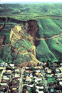
The village of La Conchita is along a portion of the coast prone to mudslides, and sits beneath a geologically unstable formation. In 1909, a devastating mudslide occurred approximately one-half mile north of the town, and in 2005 slides closed Highway 101 in both directions, trapping residents.- On March 4, 1995 at 2:03pm, a mudslide buried or damaged seven homes, injuring no one. After the main failure, the weather forecast predicted more rain for the following week.
- On March 10, 1995, a debris flow occurred in the canyon west of the March 4 slide, damaging four or five more residences and a banana plantationPlantationA plantation is a long artificially established forest, farm or estate, where crops are grown for sale, often in distant markets rather than for local on-site consumption...
. - On January 10, 2005 at 12:30pm, a massive mudslide buried four blocks of the town in over 30 feet (9 m) of earth. Ten people were killed by the slide and 14 were injured. Of the 166 homes in the community, fifteen were destroyed and sixteen more were tagged by the county as uninhabitable.
La Conchita Ranch Co. was sued by those affected by the 2005 landslide. A settlement was reached, giving the plaintiffs the company's assets and $5 million dollars.
External links
- Official website of the La Conchita community
- La Conchita Residents Stay Despite Known Risks, a National Public Radio story from January 2005
- Landslide Hazards at La Conchita, California by the USGS – A full report of landslides at La Conchita
- January 2005 California Landslide, a USGSUnited States Geological SurveyThe United States Geological Survey is a scientific agency of the United States government. The scientists of the USGS study the landscape of the United States, its natural resources, and the natural hazards that threaten it. The organization has four major science disciplines, concerning biology,...
article of the 2005 slide
- January 2005 California Landslide, a USGS
- Aerial photo from California Coastal Records ProjectCalifornia Coastal Records ProjectThe California Coastal Records Project documents the California coastline with aerial photos taken from a helicopter flying parallel to the shore. Their webpage provides access to these images....
- Wide view aerial photo by Doc Searls showing evidence of previous landslides
- La Conchita, from photographer/journalist Debbie Stock
- Victims of La Conchita mudslide
- Landslides In La Conchita, California Belong To Much Larger Prehistoric Slide – 2005 Science Daily article about a UC Santa Barbara geological analysis of La Conchita
- La Conchita group page on Facebook