
Kuskokwim River
Encyclopedia
The Kuskokwim River or Kusko River (Kusquqvak in Central Yup'ik
) is a river, 702 miles (1,129.8 km) long, in Southwest Alaska
in the United States. It is the ninth largest river in the United States by average discharge
volume at its mouth and seventeenth largest by basin drainage area.
The river provides the principal drainage for an area of the remote Alaska Interior
on the north and west side of the Alaska Range
, flowing southwest into Kuskokwim Bay
on the Bering Sea
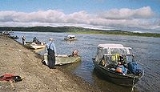
. Except for its headwaters in the mountains, the river is broad and flat for its entire course, making it a useful transportation route for many types of watercraft. It is the longest free flowing river in the United States.
Kuskokwim in Yupik
is a loose translation of a Yup'ik word to English. It is a compound word meaning big slow moving thing.
), kusquqviim, recorded by a Russian sailor in 1826. An obsolete Tanana
(Athabaskan) name for the river was Chin-ana. Upper Kuskokwim (Kolchan) is often used to mean the people of the upper parts of the river, while Eskimo people live along the lower river.
 The river is formed by the confluence
of East Fork Kuskokwim River and North Fork Kuskokwim River, 5 miles (8 km) east of Medfra. From there it flows southwest to Kuskokwim Bay
and the Bering Sea
.
The Kuskokwim is fed by several forks in central and south-central Alaska. The North Fork (250 mi/400 km) rises in the Kuskokwim Mountains
approximately 200 miles (320 km) WSW of Fairbanks
and flows southwest in a broad valley. The South Fork (200 mi/320 km) rises in the southwestern end of the Alaska Range west of Mount Gerdine and flows north-northwest through the mountains, past Nikolai
, receiving other streams that descend from the Alaska Range northwest of Mount McKinley
. The two forks join near Medfra
, and from there the main stem of the Kuskokwim flows southwest, past McGrath
, in a remote valley between the Kuskokwim Mountains to the north and the Alaska Range to the south.
In southwest Alaska the river emerges from the Kuskokwim Mountains in a vast lake-studded alluvial plain
south of the Yukon River
, surrounded by vast spruce
forests. It passes a series of Eskimo villages, including Aniak
, and approaches within 50 mi (80 km) of the Yukon before diverging southwest. Southwest of Bethel
, the largest community on the river, it broadens into a wide marshy delta that enters Kuskokwim Bay approximately 50 mi (80 km) SSW of Bethel. The lower river below Aniak is located within the Yukon Delta National Wildlife Refuge
.
The river receives the Big River from the south approximately 20 miles (32 km) southwest of Medfra. It receives the Swift
, Stony
, and Holitna
rivers from the south at the southern end of the Kuskokwim Mountains before emerging on the coastal plain. It receives the Aniak River
from the south at Aniak. Approximately 20 miles (32 km) upstream from Bethel it receives the Kisaralik and Kwethluk rivers from the south. It receives the Eek River
from the east at Eek
near its mouth on Kuskokwim Bay.
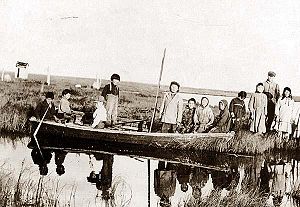
and fishing. Subsistence fishing for chinook salmon
provides a staple of the Eskimo diet along the river. Economic deposits of placer
gold were discovered in 1901 near Aniak. Mineral production in the region has mainly been from scattered placer gold deposits that through 2004 had produced a total of 3.5 million troy ounce
s of gold. The primary route of the Iditarod Trail
follows the South Fork Kuskokwim River out of the Alaska Range and crosses the main stem of the river near McGrath.
Yupik language
The Yupik languages are the several distinct languages of the several Yupik peoples of western and southcentral Alaska and northeastern Siberia. The Yupik languages differ enough from one another that speakers of different ones cannot understand each other, although they may understand the general...
) is a river, 702 miles (1,129.8 km) long, in Southwest Alaska
Southwest Alaska
Southwest Alaska is a region of the U.S. state of Alaska. The area is not exactly defined by any governmental administrative region; nor does it always have a clear geographic boundary.-Geography:...
in the United States. It is the ninth largest river in the United States by average discharge
Discharge (hydrology)
In hydrology, discharge is the volume rate of water flow, including any suspended solids , dissolved chemical species and/or biologic material , which is transported through a given cross-sectional area...
volume at its mouth and seventeenth largest by basin drainage area.
The river provides the principal drainage for an area of the remote Alaska Interior
Alaska Interior
The Alaska Interior covers most of the U.S. state's territory. It is largely wilderness. Mountains include Mount McKinley in the Alaska Range, the Wrangell Mountains, and the Ray Mountains....
on the north and west side of the Alaska Range
Alaska Range
The Alaska Range is a relatively narrow, 650-km-long mountain range in the southcentral region of the U.S. state of Alaska, from Lake Clark at its southwest end to the White River in Canada's Yukon Territory in the southeast...
, flowing southwest into Kuskokwim Bay
Kuskokwim Bay
Kuskokwim Bay is a bay in southwestern Alaska, at about . It is about long, and wide.The Kuskokwim River empties into Kuskokwim Bay. The bay got its name from the river. The largest community on the bay is the city of Quinhagak....
on the Bering Sea
Bering Sea
The Bering Sea is a marginal sea of the Pacific Ocean. It comprises a deep water basin, which then rises through a narrow slope into the shallower water above the continental shelves....
. Except for its headwaters in the mountains, the river is broad and flat for its entire course, making it a useful transportation route for many types of watercraft. It is the longest free flowing river in the United States.
Kuskokwim in Yupik
Yupik language
The Yupik languages are the several distinct languages of the several Yupik peoples of western and southcentral Alaska and northeastern Siberia. The Yupik languages differ enough from one another that speakers of different ones cannot understand each other, although they may understand the general...
is a loose translation of a Yup'ik word to English. It is a compound word meaning big slow moving thing.
Name
The river's name comes from the Yupik (EskimoEskimo
Eskimos or Inuit–Yupik peoples are indigenous peoples who have traditionally inhabited the circumpolar region from eastern Siberia , across Alaska , Canada, and Greenland....
), kusquqviim, recorded by a Russian sailor in 1826. An obsolete Tanana
Lower Tanana language
Lower Tanana is an endangered Athabaskan language spoken in Interior Alaska in the lower Tanana River villages of Minto and Nenana. Of about 380 Tanana people in the two villages, about 30 still speak the language...
(Athabaskan) name for the river was Chin-ana. Upper Kuskokwim (Kolchan) is often used to mean the people of the upper parts of the river, while Eskimo people live along the lower river.
Course
Confluence
Confluence, in geography, describes the meeting of two or more bodies of water.Confluence may also refer to:* Confluence , a property of term rewriting systems...
of East Fork Kuskokwim River and North Fork Kuskokwim River, 5 miles (8 km) east of Medfra. From there it flows southwest to Kuskokwim Bay
Kuskokwim Bay
Kuskokwim Bay is a bay in southwestern Alaska, at about . It is about long, and wide.The Kuskokwim River empties into Kuskokwim Bay. The bay got its name from the river. The largest community on the bay is the city of Quinhagak....
and the Bering Sea
Bering Sea
The Bering Sea is a marginal sea of the Pacific Ocean. It comprises a deep water basin, which then rises through a narrow slope into the shallower water above the continental shelves....
.
The Kuskokwim is fed by several forks in central and south-central Alaska. The North Fork (250 mi/400 km) rises in the Kuskokwim Mountains
Kuskokwim Mountains
The Kuskokwim Mountains is a range of mountains in the Yukon-Koyukuk Census Area, Alaska, United States, west of the Alaska Range and southeast of the Yukon River, at about . The Kuskokwim Mountains begin in the interior west of Fairbanks...
approximately 200 miles (320 km) WSW of Fairbanks
Fairbanks, Alaska
Fairbanks is a home rule city in and the borough seat of the Fairbanks North Star Borough in the U.S. state of Alaska.Fairbanks is the largest city in the Interior region of Alaska, and second largest in the state behind Anchorage...
and flows southwest in a broad valley. The South Fork (200 mi/320 km) rises in the southwestern end of the Alaska Range west of Mount Gerdine and flows north-northwest through the mountains, past Nikolai
Nikolai, Alaska
Nikolai is a city in Yukon-Koyukuk Census Area, Alaska, United States. The population was 100 at the 2000 census.-Geography:Nikolai is located at ....
, receiving other streams that descend from the Alaska Range northwest of Mount McKinley
Mount McKinley
Mount McKinley or Denali in Alaska, United States is the highest mountain peak in North America and the United States, with a summit elevation of above sea level. It is the centerpiece of Denali National Park and Preserve.- Geology and features :Mount McKinley is a granitic pluton...
. The two forks join near Medfra
Medfra, Alaska
Medfra is an unincorporated village located in the Yukon-Koyukuk Census Area in the U.S. state of Alaska.- Geography :Medra is located on the north bank of the Kuskokwim River, about by air northwest of Nikolai.- History :...
, and from there the main stem of the Kuskokwim flows southwest, past McGrath
McGrath, Alaska
As of the census of 2000, there were 401 people, 145 households, and 99 families residing in the city. The population density was 8.2 people per square mile . There were 213 housing units at an average density of 4.4 per square mile...
, in a remote valley between the Kuskokwim Mountains to the north and the Alaska Range to the south.
In southwest Alaska the river emerges from the Kuskokwim Mountains in a vast lake-studded alluvial plain
Alluvial plain
An alluvial plain is a relatively flat landform created by the deposition of sediment over a long period of time by one or more rivers coming from highland regions, from which alluvial soil forms...
south of the Yukon River
Yukon River
The Yukon River is a major watercourse of northwestern North America. The source of the river is located in British Columbia, Canada. The next portion lies in, and gives its name to Yukon Territory. The lower half of the river lies in the U.S. state of Alaska. The river is long and empties into...
, surrounded by vast spruce
Spruce
A spruce is a tree of the genus Picea , a genus of about 35 species of coniferous evergreen trees in the Family Pinaceae, found in the northern temperate and boreal regions of the earth. Spruces are large trees, from tall when mature, and can be distinguished by their whorled branches and conical...
forests. It passes a series of Eskimo villages, including Aniak
Aniak, Alaska
Aniak is a city in the Bethel Census Area in the U.S. state of Alaska. At the 2000 census the population was 572.-Geography: ....
, and approaches within 50 mi (80 km) of the Yukon before diverging southwest. Southwest of Bethel
Bethel, Alaska
Bethel is a city located near the west coast of the U.S. state of Alaska, west of Anchorage. Accessible only by air and river, Bethel is the main port on the Kuskokwim River and is an administrative and transportation hub for the 56 villages in the Yukon-Kuskokwim Delta.Bethel is the largest...
, the largest community on the river, it broadens into a wide marshy delta that enters Kuskokwim Bay approximately 50 mi (80 km) SSW of Bethel. The lower river below Aniak is located within the Yukon Delta National Wildlife Refuge
Yukon Delta National Wildlife Refuge
The Yukon Delta National Wildlife Refuge is a United States National Wildlife Refuge covering about in southwestern Alaska. It is the second-largest National Wildlife Refuge in the country, only slightly smaller than the Arctic National Wildlife Refuge. It is a coastal plain extending to the...
.
The river receives the Big River from the south approximately 20 miles (32 km) southwest of Medfra. It receives the Swift
Swift River (Alaska)
The Swift River is a river in southwestern Alaska. It is a tributary of the Kuskokwim River....
, Stony
Stony River (Alaska)
The Stony River is a river in southwest Alaska. It lends its name to Stony River, Alaska, a village with a population of 61. The river meanders westward from the Mount Mausolus area until it meets the Kuskokwim River at the community of Stony River....
, and Holitna
Holitna River
The Holitna River is a river in Alaska. It is a tributary of the Kuskokwim River....
rivers from the south at the southern end of the Kuskokwim Mountains before emerging on the coastal plain. It receives the Aniak River
Aniak River
The Aniak River is a river in Alaska, USA. Aniak is a Yup'ik word meaning "the place where it comes out," which refers to the mouth of the Aniak River...
from the south at Aniak. Approximately 20 miles (32 km) upstream from Bethel it receives the Kisaralik and Kwethluk rivers from the south. It receives the Eek River
Eek River
The Eek River is a river of Alaska. It parallels, and is located south of the Kwethluk and north of the Kanektok Rivers, all of which feed into the Kuskokwim River. It is about 75 miles long, flows through the Yukon Delta National Wildlife Refuge and becomes a tributary of the Kuskokwim River in...
from the east at Eek
Eek, Alaska
Eek is a city in Bethel Census Area, Alaska, United States. At the 2000 census the population was 280.-Geography:Eek is located at ....
near its mouth on Kuskokwim Bay.
History
The principal economic activities along the river have historically been fur trappingFur trade
The fur trade is a worldwide industry dealing in the acquisition and sale of animal fur. Since the establishment of world market for in the early modern period furs of boreal, polar and cold temperate mammalian animals have been the most valued...
and fishing. Subsistence fishing for chinook salmon
Salmon
Salmon is the common name for several species of fish in the family Salmonidae. Several other fish in the same family are called trout; the difference is often said to be that salmon migrate and trout are resident, but this distinction does not strictly hold true...
provides a staple of the Eskimo diet along the river. Economic deposits of placer
Placer mining
Placer mining is the mining of alluvial deposits for minerals. This may be done by open-pit or by various surface excavating equipment or tunneling equipment....
gold were discovered in 1901 near Aniak. Mineral production in the region has mainly been from scattered placer gold deposits that through 2004 had produced a total of 3.5 million troy ounce
Troy ounce
The troy ounce is a unit of imperial measure. In the present day it is most commonly used to gauge the weight of precious metals. One troy ounce is nowadays defined as exactly 0.0311034768 kg = 31.1034768 g. There are approximately 32.1507466 troy oz in 1 kg...
s of gold. The primary route of the Iditarod Trail
Iditarod Trail
The Iditarod Trail, also known historically as the Seward-to-Nome Mail Trail, refers to a thousand-plus mile historic and contemporary trail system in the U.S...
follows the South Fork Kuskokwim River out of the Alaska Range and crosses the main stem of the river near McGrath.
See also
- List of Alaska rivers
- List of longest rivers of the United States (by main stem)
Works cited
- Benke, Arthur C., ed., and Cushing, Colbert E., ed. (2005). Rivers of North America. Burlington, Massachusetts: Elsevier Academic Press. ISBN 0-12-088253-1.
- Bright, William. (2004). Native American Placenames of the United States. Norman, Oklahoma: University of Oklahoma Press. ISBN 0-8061-3598-0.