
Aniak, Alaska
Encyclopedia
Aniak is a city in the Bethel Census Area
in the U.S. state of Alaska
. At the 2000 census
the population was 572.
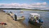
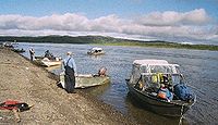
Aniak is located on the south bank of the Kuskokwim River
at the head of Aniak Slough, 59 miles (95 km) southwest of Russian Mission in the Yukon-Kuskokwim Delta. It lies 92 miles (148.1 km) northeast of Bethel and 317 miles (510.2 km) west of Anchorage.
According to the United States Census Bureau
, the city of has a total area of 8.8 square miles (22.8 km²), of which, 6.5 square miles (16.8 km²) of it is land and 2.3 square miles (6 km²) of it (25.82%) is water.
Climate is maritime in the summer and continental in winter. Temperatures range between -55 and 87. Average yearly precipitation is 19 inches (482.6 mm), with snowfall of 60 inches (1.5 m).
, 0.35% Black
or African American
, 68.36% Native American
, 0.52% Asian
, and 5.77% from two or more races. 1.05% of the population were Hispanic
or Latino
of any race.
There were 174 households out of which 51.1% had children under the age of 18 living with them, 52.9% were married couples living together, 13.2% had a female householder with 0 husbands present, and 23.0% were non-families. 20.7% of all households were made up of individuals and 4.0% had someone living alone who was 65 years of age or older. The average household size was 3.29 and the average family size was 3.74.
In the city the age distribution of the population shows 40.9% under the age of 18, 6.8% from 18 to 24, 27.3% from 25 to 44, 20.3% from 45 to 64, and 4.7% who were 65 years of age or older. The median age was 28 years. For every 100 females there were 108.8 males. For every 100 females age 18 and over, there were 107.4 males.
The median income for a household in the city was $41,875, and the median income for a family was $43,750. Males had a median income of $37,708 versus $34,500 for females. The per capita income
for the city was $16,550. About 11.8% of families and 14.0% of the population were below the poverty line, including 13.4% of those under age 18 and 12.5% of those age 65 or over.
 Aniak was the Yup'ik name for the area around present-day Aniak. The word means "the place where it comes out"; that is, where the Aniak River
flows into the Kuskokwim. By the time Russian explorers began making contact with the native population along the mid Kuskokwim valley in the early 19th century, the native village of Aniak had been deserted.
It was believed by 20th century prospectors that the early Russian traders discovered gold
in a tributary to the Kuskokwim called "Yellow River" in 1832. Many think that the Yellow River these traders referred to is the Aniak River. A mercury
deposit was discovered by Russian traders near the trading post called Kolmakov Redoubt 22 miles (35.4 km) east of Aniak in 1838. Placer gold was found by Russian traders in New York Creek 30 miles (48.3 km) east of Aniak in 1844. The Russians however did not engage in any significant mining activities and it wasn't until after the purchase of Alaska in 1867 that the American prospectors began seriously investigating the potential for prospecting along the Kuskokwim river. A handful of prospecting parties began venturing into the area, however they had to travel great distances to an area where trading posts were few and far between, so the activity was limited especially given the exposure of other late 19th century strikes in Alaska which were better served by existing infrastructure.
The euphoria caused by the Klondike Gold Rush
in 1897-98 would set the stage for a change however with thousands of prospectors across the territory poised to make a rush upon rumor of each potential new strike. One such rush was the Yellow River Stampede of 1900 in which many prospectors left Nome
to venture into the Kuskokwim basin upon rumors that someone had found the Yellow River strike despite the fact that the location of that strike was unknown. Finding precious little gold and experiencing substantial hardship, many of these folks would return to Nome following the difficult winter of 1901, but some stayed behind to continue their search. A 1906 gold discovery at the head of the Innoko River
, a tributary of the Yukon River
, caused another gold rush in 1907 with many of the prospectors choosing to access the site via the Kuskokwim River instead and trading posts were established at the Takotna River which required riverboat service to travel the Kuskokwim river. With riverboat service now available on the Kukskokwim river, prospecting activity picked up and some strikes were starting to occur in the Kuskokwim basin. Strikes were made at Crooked Creek, George River, New York Creek, and Aniak River among others. Most strikes were short lived. However, the Kuskokwim River was now seeing an increase in river traffic that needed servicing.
In 1910, a lone prospector named "Old Man" Keeler reportedly found placer gold in the Aniak River basin. In 1911, three prospectors, Harry Buhro, E. W. "Kid" Fisher, and Fred Labelle, who had been working the George River area decided to give the Aniak River basin area a try and discovered gold at Marvel, Fisher, and Dome creeks. These creeks feed into the Aniak River about 50 miles (80.5 km) south of Aniak. Initially prospectors would reach this site by poling up the river in boats, however that was a difficult journey due to the nature of the river. The trip would take 15 to 20 days from the Kuskokwim river. By 1913, a hydraulic plant had been installed at Marvel Creek and in 1914 construction of a 70 miles (112.7 km) cat trail began starting 1 miles (1.6 km) south of Aniak on the mouth of the Aniak Slough and proceeding to the diggings at Marvel Creek. The cat trail was last used in the spring of 2006 by miners still working claims.
This same year, Tom L. Johnson homesteaded the site of the long-abandoned Yup'ik village in the Aniak area and opened a store and post office there to service prospectors and miners in the vicinity. Willie Pete and Sam Simeon brought their Yup'ik families from Ohagamiut
to Aniak. In 1936 a territorial school was opened. In anticipation of the Lend-Lease
program to help supply Russia with war materials, construction of an airfield began in 1939. With the airfield in place, Aniak became the transportation hub for villages in the area including Chuathbaluk
, Anvik
, Kalskag
, Crooked Creek
, Holy Cross
and others. In 1956 during the Cold War
, construction of a White Alice
Relay Station began bringing money, jobs, and communication capability to the area. The impact to the community from the relay station was immediate as the first telephone capable of long distance phone calls was installed at the Aniak Lodge in 1957 and Aniak's population more than doubled from 142 in 1950 to 308 in 1960. The 2000 census places Aniak's population at 572.
Bethel Census Area, Alaska
Bethel Census Area is a census area located in the U.S. state of Alaska. As of 2000, the population is 16,006. It is part of the unorganized borough and therefore has no borough seat...
in the U.S. state of Alaska
Alaska
Alaska is the largest state in the United States by area. It is situated in the northwest extremity of the North American continent, with Canada to the east, the Arctic Ocean to the north, and the Pacific Ocean to the west and south, with Russia further west across the Bering Strait...
. At the 2000 census
United States Census, 2000
The Twenty-second United States Census, known as Census 2000 and conducted by the Census Bureau, determined the resident population of the United States on April 1, 2000, to be 281,421,906, an increase of 13.2% over the 248,709,873 persons enumerated during the 1990 Census...
the population was 572.
Geography
61°34′44"N 159°33′1"W (61.578821, -159.550255).Aniak is located on the south bank of the Kuskokwim River
Kuskokwim River
The Kuskokwim River or Kusko River is a river, long, in Southwest Alaska in the United States. It is the ninth largest river in the United States by average discharge volume at its mouth and seventeenth largest by basin drainage area.The river provides the principal drainage for an area of the...
at the head of Aniak Slough, 59 miles (95 km) southwest of Russian Mission in the Yukon-Kuskokwim Delta. It lies 92 miles (148.1 km) northeast of Bethel and 317 miles (510.2 km) west of Anchorage.
According to the United States Census Bureau
United States Census Bureau
The United States Census Bureau is the government agency that is responsible for the United States Census. It also gathers other national demographic and economic data...
, the city of has a total area of 8.8 square miles (22.8 km²), of which, 6.5 square miles (16.8 km²) of it is land and 2.3 square miles (6 km²) of it (25.82%) is water.
Climate is maritime in the summer and continental in winter. Temperatures range between -55 and 87. Average yearly precipitation is 19 inches (482.6 mm), with snowfall of 60 inches (1.5 m).
Demographics
As of the census of 2000, there were 572 people, 174 households, and 133 families residing in the city. The population density was 87.8 people per square mile (33.9/km²). There were 203 housing units at an average density of 31.1 per square mile (12.0/km²). The racial makeup of the city was 25.00% WhiteRace (United States Census)
Race and ethnicity in the United States Census, as defined by the Federal Office of Management and Budget and the United States Census Bureau, are self-identification data items in which residents choose the race or races with which they most closely identify, and indicate whether or not they are...
, 0.35% Black
Race (United States Census)
Race and ethnicity in the United States Census, as defined by the Federal Office of Management and Budget and the United States Census Bureau, are self-identification data items in which residents choose the race or races with which they most closely identify, and indicate whether or not they are...
or African American
Race (United States Census)
Race and ethnicity in the United States Census, as defined by the Federal Office of Management and Budget and the United States Census Bureau, are self-identification data items in which residents choose the race or races with which they most closely identify, and indicate whether or not they are...
, 68.36% Native American
Race (United States Census)
Race and ethnicity in the United States Census, as defined by the Federal Office of Management and Budget and the United States Census Bureau, are self-identification data items in which residents choose the race or races with which they most closely identify, and indicate whether or not they are...
, 0.52% Asian
Race (United States Census)
Race and ethnicity in the United States Census, as defined by the Federal Office of Management and Budget and the United States Census Bureau, are self-identification data items in which residents choose the race or races with which they most closely identify, and indicate whether or not they are...
, and 5.77% from two or more races. 1.05% of the population were Hispanic
Race (United States Census)
Race and ethnicity in the United States Census, as defined by the Federal Office of Management and Budget and the United States Census Bureau, are self-identification data items in which residents choose the race or races with which they most closely identify, and indicate whether or not they are...
or Latino
Race (United States Census)
Race and ethnicity in the United States Census, as defined by the Federal Office of Management and Budget and the United States Census Bureau, are self-identification data items in which residents choose the race or races with which they most closely identify, and indicate whether or not they are...
of any race.
There were 174 households out of which 51.1% had children under the age of 18 living with them, 52.9% were married couples living together, 13.2% had a female householder with 0 husbands present, and 23.0% were non-families. 20.7% of all households were made up of individuals and 4.0% had someone living alone who was 65 years of age or older. The average household size was 3.29 and the average family size was 3.74.
In the city the age distribution of the population shows 40.9% under the age of 18, 6.8% from 18 to 24, 27.3% from 25 to 44, 20.3% from 45 to 64, and 4.7% who were 65 years of age or older. The median age was 28 years. For every 100 females there were 108.8 males. For every 100 females age 18 and over, there were 107.4 males.
The median income for a household in the city was $41,875, and the median income for a family was $43,750. Males had a median income of $37,708 versus $34,500 for females. The per capita income
Per capita income
Per capita income or income per person is a measure of mean income within an economic aggregate, such as a country or city. It is calculated by taking a measure of all sources of income in the aggregate and dividing it by the total population...
for the city was $16,550. About 11.8% of families and 14.0% of the population were below the poverty line, including 13.4% of those under age 18 and 12.5% of those age 65 or over.
History
Aniak River
The Aniak River is a river in Alaska, USA. Aniak is a Yup'ik word meaning "the place where it comes out," which refers to the mouth of the Aniak River...
flows into the Kuskokwim. By the time Russian explorers began making contact with the native population along the mid Kuskokwim valley in the early 19th century, the native village of Aniak had been deserted.
It was believed by 20th century prospectors that the early Russian traders discovered gold
Gold
Gold is a chemical element with the symbol Au and an atomic number of 79. Gold is a dense, soft, shiny, malleable and ductile metal. Pure gold has a bright yellow color and luster traditionally considered attractive, which it maintains without oxidizing in air or water. Chemically, gold is a...
in a tributary to the Kuskokwim called "Yellow River" in 1832. Many think that the Yellow River these traders referred to is the Aniak River. A mercury
Mercury (element)
Mercury is a chemical element with the symbol Hg and atomic number 80. It is also known as quicksilver or hydrargyrum...
deposit was discovered by Russian traders near the trading post called Kolmakov Redoubt 22 miles (35.4 km) east of Aniak in 1838. Placer gold was found by Russian traders in New York Creek 30 miles (48.3 km) east of Aniak in 1844. The Russians however did not engage in any significant mining activities and it wasn't until after the purchase of Alaska in 1867 that the American prospectors began seriously investigating the potential for prospecting along the Kuskokwim river. A handful of prospecting parties began venturing into the area, however they had to travel great distances to an area where trading posts were few and far between, so the activity was limited especially given the exposure of other late 19th century strikes in Alaska which were better served by existing infrastructure.
The euphoria caused by the Klondike Gold Rush
Klondike Gold Rush
The Klondike Gold Rush, also called the Yukon Gold Rush, the Alaska Gold Rush and the Last Great Gold Rush, was an attempt by an estimated 100,000 people to travel to the Klondike region the Yukon in north-western Canada between 1897 and 1899 in the hope of successfully prospecting for gold...
in 1897-98 would set the stage for a change however with thousands of prospectors across the territory poised to make a rush upon rumor of each potential new strike. One such rush was the Yellow River Stampede of 1900 in which many prospectors left Nome
Nome, Alaska
Nome is a city in the Nome Census Area in the Unorganized Borough of the U.S. state of Alaska, located on the southern Seward Peninsula coast on Norton Sound of the Bering Sea. According to the 2010 Census, the city population was 3,598. Nome was incorporated on April 9, 1901, and was once the...
to venture into the Kuskokwim basin upon rumors that someone had found the Yellow River strike despite the fact that the location of that strike was unknown. Finding precious little gold and experiencing substantial hardship, many of these folks would return to Nome following the difficult winter of 1901, but some stayed behind to continue their search. A 1906 gold discovery at the head of the Innoko River
Innoko River
The Innoko River is a river in western Alaska. It flows north from its origin south of Cloudy Mountain in the Kuskoswim Mountains and then flows southwest to its end at the Yukon River, across from Holy Cross, Alaska....
, a tributary of the Yukon River
Yukon River
The Yukon River is a major watercourse of northwestern North America. The source of the river is located in British Columbia, Canada. The next portion lies in, and gives its name to Yukon Territory. The lower half of the river lies in the U.S. state of Alaska. The river is long and empties into...
, caused another gold rush in 1907 with many of the prospectors choosing to access the site via the Kuskokwim River instead and trading posts were established at the Takotna River which required riverboat service to travel the Kuskokwim river. With riverboat service now available on the Kukskokwim river, prospecting activity picked up and some strikes were starting to occur in the Kuskokwim basin. Strikes were made at Crooked Creek, George River, New York Creek, and Aniak River among others. Most strikes were short lived. However, the Kuskokwim River was now seeing an increase in river traffic that needed servicing.
In 1910, a lone prospector named "Old Man" Keeler reportedly found placer gold in the Aniak River basin. In 1911, three prospectors, Harry Buhro, E. W. "Kid" Fisher, and Fred Labelle, who had been working the George River area decided to give the Aniak River basin area a try and discovered gold at Marvel, Fisher, and Dome creeks. These creeks feed into the Aniak River about 50 miles (80.5 km) south of Aniak. Initially prospectors would reach this site by poling up the river in boats, however that was a difficult journey due to the nature of the river. The trip would take 15 to 20 days from the Kuskokwim river. By 1913, a hydraulic plant had been installed at Marvel Creek and in 1914 construction of a 70 miles (112.7 km) cat trail began starting 1 miles (1.6 km) south of Aniak on the mouth of the Aniak Slough and proceeding to the diggings at Marvel Creek. The cat trail was last used in the spring of 2006 by miners still working claims.
This same year, Tom L. Johnson homesteaded the site of the long-abandoned Yup'ik village in the Aniak area and opened a store and post office there to service prospectors and miners in the vicinity. Willie Pete and Sam Simeon brought their Yup'ik families from Ohagamiut
Ohagamiut, Alaska
Ohagamiut was a Yup'ik village along the Kuskokwim River in the Bethel Census Area of the southwestern part of the U.S. state of Alaska, located between Crow Village and Kalskag. It was abandoned in the 1940s as residents relocated to Kalskag, Aniak, Bethel and other towns...
to Aniak. In 1936 a territorial school was opened. In anticipation of the Lend-Lease
Lend-Lease
Lend-Lease was the program under which the United States of America supplied the United Kingdom, the Soviet Union, China, Free France, and other Allied nations with materiel between 1941 and 1945. It was signed into law on March 11, 1941, a year and a half after the outbreak of war in Europe in...
program to help supply Russia with war materials, construction of an airfield began in 1939. With the airfield in place, Aniak became the transportation hub for villages in the area including Chuathbaluk
Chuathbaluk, Alaska
Chuathbaluk is a city in Bethel Census Area, Alaska, United States. At the 2000 census the population was 119.-Geography:Chuathbaluk is located at ....
, Anvik
Anvik, Alaska
Anvik is a city, home to the Deg Hit'an people, in the Yukon-Koyukuk Census Area, Alaska, United States. The name Anvik, which became the common usage despite multiple names at the time, may have come from early Russian explorers. The native name in the Deg Xinag language is Deloy Ges...
, Kalskag
Upper Kalskag, Alaska
Upper Kalskag is a city in Bethel Census Area, Alaska, United States. At the 2000 census the population was 230.-Geography:Upper Kalskag is located at ....
, Crooked Creek
Crooked Creek, Alaska
Crooked Creek is a census-designated place in Bethel Census Area, Alaska, United States. As of the 2000 census, the population of the CDP is 137.-Geography:Crooked Creek is located at ....
, Holy Cross
Holy Cross, Alaska
Holy Cross is a city in Yukon-Koyukuk Census Area, Alaska, United States...
and others. In 1956 during the Cold War
Cold War
The Cold War was the continuing state from roughly 1946 to 1991 of political conflict, military tension, proxy wars, and economic competition between the Communist World—primarily the Soviet Union and its satellite states and allies—and the powers of the Western world, primarily the United States...
, construction of a White Alice
White Alice Communications System
The White Alice Communications System was a United States Air Force telecommunication link system constructed in Alaska during the cold war. It featured tropospheric scatter links and line-of-sight microwave radio links...
Relay Station began bringing money, jobs, and communication capability to the area. The impact to the community from the relay station was immediate as the first telephone capable of long distance phone calls was installed at the Aniak Lodge in 1957 and Aniak's population more than doubled from 142 in 1950 to 308 in 1960. The 2000 census places Aniak's population at 572.