
Kushalnagar
Encyclopedia
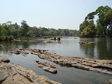
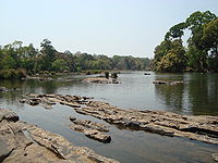
Kushalanagara is a town located in the east of Kodagu
district, near the Kaveri river, in the state of Karnataka
, India
. In pre-Independence times, it was known as Fraserpet after Colonel Fraser who was the Political Agent in Coorg around 1834..The town is located on Mangalore
-Mysore state highway(SH 88).
R.Gundu Rao , former Chief Minister of Karnataka
state, India
, hails from this town.
The Bylakuppe
settlement for Tibetan refugees is nearby in Mysore district
. Other nearby tourist attractions include Harangi Reservoir
, Dubare
, Nisargadhama
, chiklihole, herur
,
, Kushalnagara had a population of 13,262. Males constitute 53% of the population and females 47%. Kushalnagar has an average literacy rate of 78%, higher than the national average of 59.5%: male literacy is 82%, and female literacy is 73%. 12% of the population is under 6 years of age.
, Kannada and Kodava Takk
. Tibetan
is also spoken by Tibetan settlers.
Kodagu
Kodagu , also known by its anglicised former name of Coorg, is an administrative district in Karnataka, India. It occupies an area of in the Western Ghats of southwestern Karnataka. As of 2001, the population was 548,561, 13.74% of which resided in the district's urban centres, making it the least...
district, near the Kaveri river, in the state of Karnataka
Karnataka
Karnataka , the land of the Kannadigas, is a state in South West India. It was created on 1 November 1956, with the passing of the States Reorganisation Act and this day is annually celebrated as Karnataka Rajyotsava...
, India
India
India , officially the Republic of India , is a country in South Asia. It is the seventh-largest country by geographical area, the second-most populous country with over 1.2 billion people, and the most populous democracy in the world...
. In pre-Independence times, it was known as Fraserpet after Colonel Fraser who was the Political Agent in Coorg around 1834..The town is located on Mangalore
Mangalore
Mangalore is the chief port city of the Indian state of Karnataka. It is located about west of the state capital, Bangalore. Mangalore lies between the Arabian Sea and the Western Ghat mountain ranges, and is the administrative headquarters of the Dakshina Kannada district in south western...
-Mysore state highway(SH 88).
R.Gundu Rao , former Chief Minister of Karnataka
Karnataka
Karnataka , the land of the Kannadigas, is a state in South West India. It was created on 1 November 1956, with the passing of the States Reorganisation Act and this day is annually celebrated as Karnataka Rajyotsava...
state, India
India
India , officially the Republic of India , is a country in South Asia. It is the seventh-largest country by geographical area, the second-most populous country with over 1.2 billion people, and the most populous democracy in the world...
, hails from this town.
Geography
Kushalnagara is located at 12.47°N 75.97°E. It has an average elevation of 831 metres (2726 feet).The Bylakuppe
Bylakuppe
Bylakuppe kannada:ಬೈಲಕುಪ್ಪೆ, Tibetian:བལཀུཔེ is the location of "Lugsum Samdupling" and "Dickyi Larsoe" , two adjacent Tibetan refugee settlements, as well as a number of Tibetan Buddhist monasteries. The area is located in the west of the Mysore district in the Indian state of Karnataka...
settlement for Tibetan refugees is nearby in Mysore district
Mysore district
Mysore District is an administrative district located in the southern part of the state of Karnataka, India. The district is bounded by Mandya district to the northeast, Chamrajanagar district to the southeast, Kerala state to the south, Kodagu district to the west, and Hassan district to the north...
. Other nearby tourist attractions include Harangi Reservoir
Harangi Reservoir
Harangi Reservoir is located near Hudgur village, Somwarpet taluk in Kodagu district in the Indian state of Karnataka. The reservoir is formed by a masonry dam built across Harangi River, a tributary of Kaveri River. The dam is located about 9 km away from the heart of Kushalnagar town.The...
, Dubare
Dubare
Dubare is known for its elephant camp, and is a forest camp on the banks of the river Kaveri in the district of Kodagu, Karnataka. It is an important base for the Karnataka Forest Department's elephants....
, Nisargadhama
Nisargadhama
Kaveri Nisargadhama is an island formed by river Kaveri and is used as a picnic spot near Kushalnagar in the district of Kodagu in Karnataka. It is approximately from Kushalanagara, off the State Highway and from Madikeri and from Mysore...
, chiklihole, herur
Herur
Herur is a village in the southern state of Karnataka, India. It is located in the Gangawati taluk of Koppal district in Karnataka.-Demographics:As of 2001 India census, Herur had a population of 5260 with 2672 males and 2588 females....
,
Demographics
India censusCensus
A census is the procedure of systematically acquiring and recording information about the members of a given population. It is a regularly occurring and official count of a particular population. The term is used mostly in connection with national population and housing censuses; other common...
, Kushalnagara had a population of 13,262. Males constitute 53% of the population and females 47%. Kushalnagar has an average literacy rate of 78%, higher than the national average of 59.5%: male literacy is 82%, and female literacy is 73%. 12% of the population is under 6 years of age.
Languages
The main languages in Kushalanagara are Are BhasheAre Bhashe
Arebhashe or Gowda Kannada is a dialect of the Kannada language, particularly, spoken by the people belonging to ‘Gowda’ community who are the natives of Madikeri, Somwarpet, Bhagamandala and Kushalanagara of Kodagu district and Sullia of Dakshina Kannada. It is also spoken by eastern parts of...
, Kannada and Kodava Takk
Kodava Takk
Kodava Takk or Kodava takka, is the original language of the south Karnataka district of Kodagu. The language is often called Kodava or Coorg language in English. The number of speakers is estimated at up to about 500,000. It is the primary language of Kodavas, but a large portion of other...
. Tibetan
Tibetan language
The Tibetan languages are a cluster of mutually-unintelligible Tibeto-Burman languages spoken primarily by Tibetan peoples who live across a wide area of eastern Central Asia bordering the Indian subcontinent, including the Tibetan Plateau and the northern Indian subcontinent in Baltistan, Ladakh,...
is also spoken by Tibetan settlers.