
Harangi Reservoir
Encyclopedia
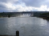
Harangi Reservoir is located near Hudgur village, Somwarpet
taluk in Kodagu
district in the Indian state of Karnataka
. The reservoir is formed by a masonry dam
built across Harangi River, a tributary
of Kaveri River
. The dam is located about 9 km away from the heart of Kushalnagar
town.
The Harangi river originates from the Pushpagiri
Hills of Western Ghats
in Kodagu
, Karnataka
. Heavy rainfall from the south-west monsoon is the source of water in the catchment area of Harangi river which is about 717 km2. The length of the Harangi river from its origin to the confluence with the Kaveri river is 50 km. The Harangi river joins Kaveri near Kudige in Somwarpet
taluk.
Somwarpet
Somwarpet is a panchayat town in Kodagu district in the Indian state of Karnataka...
taluk in Kodagu
Kodagu
Kodagu , also known by its anglicised former name of Coorg, is an administrative district in Karnataka, India. It occupies an area of in the Western Ghats of southwestern Karnataka. As of 2001, the population was 548,561, 13.74% of which resided in the district's urban centres, making it the least...
district in the Indian state of Karnataka
Karnataka
Karnataka , the land of the Kannadigas, is a state in South West India. It was created on 1 November 1956, with the passing of the States Reorganisation Act and this day is annually celebrated as Karnataka Rajyotsava...
. The reservoir is formed by a masonry dam
Masonry dam
Masonry dams are dams made out of masonry; mainly stone and brick. They are either the gravity or the arch type.The largest masonry dam of the world is Nagarjunasagar Dam in India....
built across Harangi River, a tributary
Tributary
A tributary or affluent is a stream or river that flows into a main stem river or a lake. A tributary does not flow directly into a sea or ocean...
of Kaveri River
Kaveri River
The Kaveri , also spelled Cauvery in English, is a large Indian river. The origin of the river is traditionally placed at Talakaveri, Kodagu in the Western Ghats in Karnataka, flows generally south and east through Karnataka and Tamil Nadu and across the southern Deccan plateau through the...
. The dam is located about 9 km away from the heart of Kushalnagar
Kushalnagar
Kushalanagara is a town located in the east of Kodagu district, near the Kaveri river, in the state of Karnataka, India. In pre-Independence times, it was known as Fraserpet after Colonel Fraser who was the Political Agent in Coorg around 1834..The town is located on Mangalore -Mysore state...
town.
The Harangi river originates from the Pushpagiri
Pushpagiri
Pushpagiri, at 1,712 meters, is the highest peak in Pushpagiri Wildlife Sanctuary in the Western Ghats of Karnataka. It is located in the Somwarpet Taluk, 20 km from Somwarpet Town northern part of Kodagu district.-Pushpagiri Mountains:...
Hills of Western Ghats
Western Ghats
The Western Ghats, Western Ghauts or the Sahyādri is a mountain range along the western side of India. It runs north to south along the western edge of the Deccan Plateau, and separates the plateau from a narrow coastal plain along the Arabian Sea. The Western Ghats block rainfall to the Deccan...
in Kodagu
Kodagu
Kodagu , also known by its anglicised former name of Coorg, is an administrative district in Karnataka, India. It occupies an area of in the Western Ghats of southwestern Karnataka. As of 2001, the population was 548,561, 13.74% of which resided in the district's urban centres, making it the least...
, Karnataka
Karnataka
Karnataka , the land of the Kannadigas, is a state in South West India. It was created on 1 November 1956, with the passing of the States Reorganisation Act and this day is annually celebrated as Karnataka Rajyotsava...
. Heavy rainfall from the south-west monsoon is the source of water in the catchment area of Harangi river which is about 717 km2. The length of the Harangi river from its origin to the confluence with the Kaveri river is 50 km. The Harangi river joins Kaveri near Kudige in Somwarpet
Somwarpet
Somwarpet is a panchayat town in Kodagu district in the Indian state of Karnataka...
taluk.