
Kilham, East Riding of Yorkshire
Encyclopedia
East Riding of Yorkshire
The East Riding of Yorkshire, or simply East Yorkshire, is a local government district with unitary authority status, and a ceremonial county of England. For ceremonial purposes the county also includes the city of Kingston upon Hull, which is a separate unitary authority...
, England
England
England is a country that is part of the United Kingdom. It shares land borders with Scotland to the north and Wales to the west; the Irish Sea is to the north west, the Celtic Sea to the south west, with the North Sea to the east and the English Channel to the south separating it from continental...
. It is situated about 5 miles (8 km) north-east of Driffield
Driffield
Driffield, also known as Great Driffield, is a market town and civil parish in the East Riding of Yorkshire, England. The civil parish is formed by the town of Driffield and the village of Little Driffield....
town centre.
According to the 2001 UK census
United Kingdom Census 2001
A nationwide census, known as Census 2001, was conducted in the United Kingdom on Sunday, 29 April 2001. This was the 20th UK Census and recorded a resident population of 58,789,194....
, Kilham parish had a population of 1,010.
Kilham was once an important market town in the Yorkshire Wolds
Yorkshire Wolds
The Yorkshire Wolds are low hills in the counties of East Riding of Yorkshire and North Yorkshire in northeastern England. The name also applies to the district in which the hills lie....
, bigger and more important than Driffield at one time. It held annual trading fairs and had a large number of businesses and a considerable population. The town declined in size and status following the building of the Driffield Navigation
Driffield Navigation
The Driffield Navigation is an waterway, through the heart of the Holderness Plain to the market town of Driffield, East Riding of Yorkshire, England. The northern section of it is a canal, and the southern section is part of the River Hull. Construction was authorised in 1767, and it was fully...
, which took trade away from Kilham to nearby Driffield.
At one time there were six schools in the village, but only one now remains, Kilham C. of E. primary school.
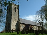
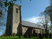
All Saints Church stands on a rise in a commanding position. It is a Norman church with some interesting carvings in the walls of its massive tower. The doorway is adorned with exquisite chevron mouldings from the 17th century. The church hosts an annual flower festival which attracts many people.
Outside the church can be found an old tethering ring in a stone block - a reminder of the cattle trade which once took place in the village. There is also a cast-iron water pump opposite All Saints, another reminder of days gone by.
David Byas
David Byas
David Byas is an English first-class cricketer, who played for Yorkshire and latterly Lancashire....
, the former Yorkshire cricket
Cricket
Cricket is a bat-and-ball game played between two teams of 11 players on an oval-shaped field, at the centre of which is a rectangular 22-yard long pitch. One team bats, trying to score as many runs as possible while the other team bowls and fields, trying to dismiss the batsmen and thus limit the...
captain, was born in Kilham.
In 2010, the Kilham Playing Field Association successfully opened a recreational Playing field on Back Lane in Kilham which will provide a full-sized football pitch, a 5-a-side football pitch, grass tennis courts, adventure playground and cycle track. The Association has been funded locally and through the Big Lottery fund and Grassroots. The association is a registered charity.
Other villages near Kilham:
Ruston Parva
Ruston Parva
Ruston Parva is a hamlet in the East Riding of Yorkshire, England. It is situated approximately south west of Bridlington and lies just north of the A614 road.It forms part of the civil parish of Harpham....
(1 miles (1.6 km))*, Harpham
Harpham
Harpham is a small village and civil parish in the East Riding of Yorkshire, England. It is located just south of the A614 road, approximately north east of Driffield and south west of Bridlington....
(2 miles (3.2 km)), Lowthorpe
Lowthorpe
Lowthorpe is a village in the East Riding of Yorkshire, England. It is situated approximately north east of Driffield town centre and south west of Bridlington town centre....
(2 miles (3.2 km)), Nafferton
Nafferton
Nafferton is a village and civil parish in the East Riding of Yorkshire, England. It is situated approximately north east of Driffield town centre and lies just south of the A614 road....
(2 miles (3.2 km)), Burton Agnes
Burton Agnes
Burton Agnes is a village and civil parish in the East Riding of Yorkshire, England. It is situated on the A614 mid way between Driffield and Bridlington. Places of interest include an Elizabethan Manor House, Burton Agnes Hall and a Norman Manor House, Burton Agnes Manor House...
(3 miles (4.8 km)), Rudston
Rudston
Rudston is a small village and civil parish in the East Riding of Yorkshire, England. It is situated between Driffield and Bridlington approximately to the west of Bridlington, and lies on the B1253 road....
(3 miles (4.8 km)), Thwing
Thwing
Thwing is a small village in the Yorkshire Wolds, in the East Riding of Yorkshire, England. It is situated approximately from the east coast, just north of the B1253 road. The nearest neighbouring towns are Driffield to the south, Bridlington to the east, Filey to the north east and...
(3 miles (4.8 km)), Little Driffield
Little Driffield
Little Driffield is a small village in the East Riding of Yorkshire,England. It is situated on the western outskirts of Great Driffield, to the west of the A614 road and south of the A166 road. Little Driffield forms part of the civil parish of Driffield....
(4 miles (6.4 km)), Driffield
Driffield
Driffield, also known as Great Driffield, is a market town and civil parish in the East Riding of Yorkshire, England. The civil parish is formed by the town of Driffield and the village of Little Driffield....
(4 miles (6.4 km)), Burton Fleming
Burton Fleming
Burton Fleming is a village and civil parish in the East Riding of Yorkshire, England. It lies close to the border with North Yorkshire. The village is situated approximately north west of Bridlington and south of Filey in North Yorkshire....
(5 miles (8 km)), Carnaby
Carnaby
Carnaby is a small village and civil parish on the A614 road in the East Riding of Yorkshire, England. It is situated approximately south west of Bridlington town centre....
(5 miles (8 km)), Foston on the Wolds
Foston on the Wolds
Foston on the Wolds is a village and civil parish in the East Riding of Yorkshire, England. It is situated approximately south west of Bridlington town centre and north of the village of North Frodingham....
(5 miles (8 km)), Boynton
Boynton, East Riding of Yorkshire
Boynton is a village and civil parish in the East Riding of Yorkshire, England. It is situated approximately west of the town of Bridlington and lies on the B1253 road.According to the 2001 UK census, Boynton parish had a population of 161....
(5 miles (8 km)), Fraisthorpe
Fraisthorpe
Fraisthorpe is a village in the East Riding of Yorkshire, England. It is situated approximately south of Bridlington town centre. It lies to the east of the A165 road.Together with Barmston it forms the civil parish of Barmston and Fraisthorpe....
(5 miles (8 km)).
- *Distances shown are in a direct line. Distances by road will be longer.
Romano-Anglian settlement
To the south of Kilham there is evidence of a Romano-Anglian settlement from the 4th century.http://www.geograph.org.uk/photo/1269419 (Not to be confused with Kilham, NorthumberlandKilham, Northumberland
Kilham is a hamlet and civil parish in the English county of Northumberland, located west of Wooler, east of Kelso, south west of Berwick upon Tweed and north west of Morpeth. It lies on the northern edge of the Northumberland National Park in Glendale...
, which also has evidence of a Roman settlement.
External links
- Driffield.co.uk - The Villages of the Yorkshire Wolds, Kilham.
- GENUKI: Kilham Parish information from Pigot's 1834.
- UKMills - UK Mills - Kilham Windmill, East Yorkshire.
- Windmillworld - Kilham Windmill, East Yorkshire.
- KPFA - Kilham Playing Field Association
- KilhamSchool.co.uk - Kilham Church of England Primary School