

Kilbirnie Loch
Encyclopedia
Kilbirnie Loch is situated in the floodplain of between Kilbirnie
, Glengarnock
and Beith
, and runs south-west to north-east for almost 2 km (1.2 mi), is about 0.5 km (0.310686368324903 mi) wide for the most part and has an area of roughly 3 km2 (761 acres). It has a general depth of around 5.2 metres (17 feet) to a maximum of around 11 metres (36 feet). The loch is fed mainly by the Maich Water, which rises in the Kilbirnie Hills near Misty Law (507m or 1663 feet), and is drained by the Dubbs Water that runs into Castle Semple Loch
, followed by the Black Cart, the White Cart at Renfrew
and finally the River Clyde
. The boundary between East Renfrewshire
and North Ayrshire
, in the vicinity of the loch, runs down the course of the Maich Water along the northern loch shore to then run up beside the Dubbs Water.
(1465–1536) is the first to publish a reference to the loch, using the name 'Garnoth', in his book of 1527 the 'Historia Gentis Scotorum' (History of the Scottish People), saying that nocht unlike the Loch Doune full of fische. There is a long history of drainage schemes and farming operations in the area, with co-ordinated attempts dating from about 1691 by Lord Sempill
, followed by Colonel McDowal of Castle Sempil in 1774, James Adams of Burnfoot, and by others. Until these drainage works the two lochs nearly met and often did during flooding, to the extent that early writers such as Boece, Hollings and Petruccio Ubaldini
regarded the lochs as one, using the name 'Garnoth' or 'Garnott'. The Castle Semple and Barr Lochs lie in an area previously covered until more recently by one large loch known as ‘Loch Winnoch’, however by the end of the 18th century silt from the River Calder had divided the loch into two. In 1814 Barr Loch and the Aird Meadow was bunded and drained, however after WW2 the area was gradually abandoned for agriculture.
'Loc Tancu' is seemingly the earliest recorded name from circa 1210 and the name 'Loch Tankard', 'Thankard' or 'Thankart' was used locally. A farm named 'Unthank' or 'Onthank' existed until the 19th century near to the old Nether Mill opposite the lost 'Cairn' island and together with 'Thankard' may be derived from 'Tancu'. The term 'Garnoth' has also been used and may derive from 'Garnock'. In early feudal times many Flemings were granted land in the valley of the Clyde, including an individual named 'Thankard', who gave his name to Tankerton, Wice in Wiston, Lambin in Lamington and William, the ancestor of the family of Douglas. A Lochend Farm existed in the area that is now occupied by Glengarnock.
Early maps, circa 1600, show the two lochs with separate names, but effectively a continuous body of water.
The place name 'Kerse' used for the farms and the bridge at the northern end of the loch refers in Scots
to 'Low and fertile land adjacent to a river or loch'. The old Barony of Kersland was held by the Kerr family; by chance or by association with this site the surname Kerr
may derive from the nature of the location. The term 'Loch of Kilbirnie' is sometimes found in books, on older maps, etc.
The loch is situated in the Parish of Kilbirnie and the ancient Barony of Glengarnock
once held by the Cuninghams, a cadet branch of the Earls of Glencairn
from Kilmaurs
; it later formed part of the estate of the Crawfurds of Kilbirnie as a result of the Honourable Patrick Lindsay acquiring, in 1677, the Glengarnock estates and marrying Margaret, heiress of Sir John Crawfurd of Kilbirnie. Their son became the first Viscount Garnock
and in 1707 he had the baronies of Kilrbirnie and Glengarnock combined under into the 'Barony of Kilbirnie'.
As stated, the loch once belonged to the Cunninghames of Glengarnock
, but the Craufurds of Kilbirnie disputed their rights over rowing and fishing; these families broke one anothers' boats, etc. until inter-marriage solved the problem. Both clans had the loch included in their charters.
The boundary shown in 1654 between the baronies of Kilbirnie and Renfrew did not follow the Maich Water and Dubbs Water, it even ran into the loch itself, reflecting the aforementioned disputes.
In 1775 Armstrong's map records 'Loch Tankard' as the property of the Earl of Crawford, but holds of the Prince of Wales.
In the 1860s the loch was owned by James, Earl of Glasgow
.
The loch is now owned by Scottish Enterprise, however 'riparian
owners' possess the loch shoreline and have certain duties and obligations as well as rights.
lake dwelling (see 'Archaeology'). Infill operations completely destroyed then island in due course.
An artificial island was created at the south-east end of the loch for nesting birds in the 1980s.
; a 'Flax Pond' for rhetting flax
, as part of the process of linen manufacture, is also shown nearby on the loch bank; it is now visible as a wet area dominated by rushes. The firm of William & James Knox, linen thread manufacterers, established as early as 1788, are still based in Kilbirnie. Scotland was amongst the first producers of flax. The road running down to the loch here from Baxter Head became known locally as the 'Shanks-McEwan Road' after the company that was contracted to remove the old steelwork's slag heaps.
The Glengarnock Ironworks and the later steelworks produced slag and other wastes which were disposed of into the loch, significantly reducing its size and depth. The south-west section of the loch is still hazardous due to slag lying close to the surface. The Dubbs Water was originally dug as a canal in the late 18th century for transporting coal and iron ore to the steelworks and to take finished products to their markets. Roads were unsuitable for transport of heavy goods at the time and the railways were in their infancy.
. The drift geology includes a layer of peat to the North and boulder clay and lake alluvium over the lower catchment zone. Soils are alluvium
to the North and Southeast, whilst to the East and West poorly drained non-calcareous gley
soils predominate.
 In 1868 a crannog
, its causeway and up to four logboats were revealed at the south-west corner of the loch as a result of dumping of furnace-slag from the now closed ironworks, causing the lake-bed sediments to be pushed upwards so that the crannog and logboat remains were exposed above the surface of the water. A site known as 'The Cairn' was already recognised, being exposed during exceptionally low water conditions. The crannog and causeway are marked on the 1st edition of the OS 6-inch map (Ayrshire, sheet viii) at NS 3238 5356.
Two of the boats were recorded in some detail. The most complete of the logboats was 18' (5.5m) in length, 3' (0.9m) in breadth and circa 2' (0.6m) in 'depth'; about 2' (0.6m) had been lost from the bow. The stern was 'square'. A tripod pit and a bronze ewer were found in one of the boats, now preserved at the Royal Museum of Scotland. These items were not contemporary with the logboat. The boat itself disintegrated rapidly on exposure to air. Part of a second logboat was subsequently found 'close by the island'; its fate is not recorded. This boat was worked from 'oak'.
In May 1952 part of a logboat was found on the west side of the loch and on the property of the Glengarnock Steelworks; slag-dumping operations were responsible for revealing it. Analysis of pollen from the mud found in the timber suggested that the logboat was from between about 3000 and 700bc. The surviving portion of the boat was donated to Paisley Museum.
The southern end of the loch was the site of infill with slag and other wastes from 1841 onwards, the greatest loss of open water being between 1859 and 1909. By 1930 the southern end infill had largely ceased, however infill from the west bank continued for some time.
 At the Kilbirnie end the loch can be accessed by following the B777 to the Lochshore Industrial Estate. This provides ample parking and the road leads to the boat launching area in the south-west corner of the loch.
At the Beith end the unclassified 'Kerse' road runs between Beith and the A760 enables access to the northern shore of the loch. Parking along the roadside is difficult. At the railway bridge (NS 338 552) close to the old station is a rough track which leads down to the lochside and parking in this area is hazardous. The track and the area at the bottom are used by the local Kayak
Club. Access to the land along the north shore is dependent upon the good will of the landowner at Kerse Bridge Kennels.
Part of the Sustrans
National Route 7 runs close to the loch, starting at Paisley Canal railway station
and following the same route as National Route 75 until Johnstone, passing Elderslie
and continuing south-west to Kilbarchan
, Lochwinnoch
and Kilbirnie, passing by Castle Semple, Barr as well as Kilbirnie Loch. Cycle paths runs on down via Glengarnock, Dalgarven
and Kilwinning to Ardrossan, Irvine and beyond.
A passenger ferry also ran across the loch at one time, most likely from near the old Lochside Farm, which is reached by a lane from Stonyholm, across to the Bark Mills delta
where the silt from the mains burn has encroached into the loch and a small jetty existed. The old Beith Mid Road then led up into the town itself.
 Plantations are recorded as having existed at Willowyard near Beith from the 19th century and some woodland policies still survive; the southern end had the Lady Mary's planting, but the northern end was devoid of trees. The old industrial sites on the western shore, for the first 0.75 km or so have substantial Willow plantations and there are some groups of older deciduous trees. Beyond the plantations, and continuing round the loch into the very north-east corner, farmland borders the loch. The Bark Mill near Mains House may be responsible for the loss of the oak trees from around the loch. The virtual absence of emergent vegetation is a characteristic of the loch and may be linked to the consolidated substrate.
Castle Semple and Barr Lochs are SSSIs and Kilbirnie Loch is a Scottish Wildlife Trust
designated LSNC (Local Site for Nature Conservation) in terms of the Ayrshire Local Biodiversity Action Plan (ALBAP) and in partnership with North Ayrshire Council. High levels of invasive alien waterweed species, Canadian waterweed (Elodea canadensis) and Nuttall’s waterweed (Elodea nuttalli) if left unchecked, will continue to spread and overwhelm other native aquatic plants. The loch's southern end is dominated by large areas of mown grass with mature grown bushes and wood copses. The western shore for the first 0.75 km or so is composed of planted Willow with some older deciduous trees; round the loch into the very north-east corner, pastures surround the loch. Along the western part, the ground slopes quite steeply down to the loch. The northern shore itself is level and there are areas of marshy ground. The eastern side of the loch is a narrow strip of reedbed and bogbean grows in sheltered area.
The Mains and Willowyard burns feed the loch from the eastern side and the Black Burn enters from the north-west; both have brought in silt that has created the areas of reedbeds. In addition to the Dubbs Water, a small burn, now piped, drains into the loch at the southern end.
The dominant plant of the waters edge is reed canary grass running from the East round to the South and into the West side. Creeping bent, reed sweet grass and iris are abundant. Common water-crowfoot, Chara
species, Canadian waterweed, slender spike-rush, perfoliate pondweed and spiked water milfoil are the other main species present.
The diatom
s species Capucina and Asterionella
have been recorded, together with blue-green algae, Copepods, and some Rotifer
s. Oligochaete worms, snails, freshwater louse, leeches, mayflies, caddisfly larvae, beetles, Chironomid larvae, 6-spotted burnet moth, green-veined white, common blue, blue damsel fy, are all present.
); Carex aquatilis
; Viper's bugloss (Echium vulgare); Marestail (Hippuris vulgaris); Field scabious (Knautia arvensis
); Spiked water-milfoil (Myriophyllum spicatum
); Shoreweed (Littorella uniflora); Butterfly orchid (Platanthera chlorantha
); Ivy-leaved crowfoot (Ranunculus hederaceus); Weld (Reseda luteola
); Marsh yellow-cress (Rorippa islandica); Bay willow (Salix pentandra); Creeping yellow-cress (Rorippa sylvestris
); and the relatively rare plant, Bogbean (Menyanthes trifoliata), that grows in sheltered areas on the west bank of the loch.
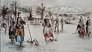 Before the advent of the ironworks the loch was used for curling and in the 19th century the Paisley Saint Mirren Curling Club records show that they played in matches for Royal Caledonian Curling Club medals at Kilbirnie Loch. The John Bull Magazine records that on the 10th January 1850 a match took place on the loch between the Eglinton Kilwinning and Beith Fullwoodhead Clubs with six rinks each and a medal given by the Royal Caledonian Club. The Eglinton team were the victors and the Earl accepted the medal from the umpire, Mr Brown of Broadstone
. A large number of spectators were present. A Bonspiel
took place at the nearby Barr Loch on 11 January 1850 and attracted huge crowds. The North won for the first time by a majority of 233 shots. The Curling Stone manufacturer, J & W Muir, were at one time based in Beith
.
'The History of Curling. 1800-1833' records that 'In Beith there were then, as there are now, many keen and good curlers who flocked down to Kilbirnie when the "icy chain' was safely thrown over it.
Circa 1604 it is recorded by Timothy Pont
that Loch of Killburney it is ye goodliest frech vatter in all Cuninghame and in 1641 Sir John Crawfurd was ratified as holding the fishing rights. In 1876 it is recorded as being well stored with pike, trout, perch, braize (bream) and eels.
The Willow plantations, other deciduous species and scrub on the western slopes provide cover for Great Spotted Woodpecker, tits, thrushes, finches, and warblers and other passerines. The north-eastern corner and the north shore provide shallower, marshier habitats where waders such as Common Snipe, Redshank, and Curlew. The hawthorn and other tree cover in this area create cover and feeding for finches, tits, and thrushes, prey for Sparrowhawks. A Great Grey Shrike was seen here in December 2001. Historical records include Storm and Leach's Petrel, Ruff, Puffin and Kittiwake in the period 1889 to 1915. The loch is a Wetland Birds Survey (WeBS) site and total count results are available on the WeBS site.
The club has a tournament standard slalom course and uses a Nautique 196 ski boat. It is open for skiing from 1 April to 30 September on Monday, Wednesday and Friday evenings and also on Saturday and Sunday afternoons.
plays on the Lochshore Playing fields, what was part of the old loch area, infilled by the iron and steelworks in the 19th century. The club is an amateur rugby union
club and currently plays in the Scottish National League Division 1. The club was formed in 1972 as the result of a merger of the Old Spierians and Dalry High School FP clubs. This was a response to the amalgamation of feeder schools Spier's and Dalry High (along with Kilbirnie Central and Beith Academy) to form Garnock Academy, which happened around the same time. The Old Spierians club had been founded in the early years of the 20th century and joined the Scottish Rugby Union
in 1911.
Handkea exipuliformis
The Pestle puffball fungus (Handkea exipuliformis) grows at the edge of the mainly birch scrub area. This large puffball fungus releases its spores by the decay of the head portion, leaving a pestle-like stem that persists through to the following summer.
's survey marks the property as 'Williezeards'.
The surviving Willowyard House dates from 1727 as `727J' or `Z27J' is carved on the exterior of the house. Circa 1750 a William Simson is recorded as the owner. By the end of the 18th century Willowyards was a well established farmstead and the Edinburgh Advertiser describes it as: consisting of about 175 English acres of arable land, well enclosed and subdivided into fifteen fields, and let by one lease to three substantial tenants for 19 years at £130 per annum. Upon this property there is a good house, and garden stocked with fruit trees, a malt mill and an elegant court of offices newly erected. A valuable flag and stone quarry has been opened in the ground and it is believed there are both coal and limestone in it. There are about ten acres of wood and a good deal of timber on this farm; and thriving belts of planting surround the greatest part of it.
In 1820 Willowyard is recorded as being an estate of 120 acres, well planted up by the owner with belts of plantings and the fine house situated in full view of the loch. The estate sits on whinstone and a small quarry nearby became an ornamental lake. In 1820 John Neil Esq of Edinburgh was the owner, however by 1822 the owner of Willowyard is recorded as being Robert Steele, a Port Glasgow
ironmaster and the lands were assessed as the 14th most valuable in the parish at £114 per year valued rent. The 1827 map by Aitken marks the estate as being the property of Robert Steel Esq. In the New Statistical Account, William Wilson, a maternal descendent of previous owners purchaded the estate in 1832 and in 1839 Alexander Shedden is noted as the owner.
The Willowyard Industrial Estate is situated between Kilbirnie loch and the town of Beith. A large whisky bond is located in the area with a number of large storage buildings and Willowyard House still stands, converted into offices serving a chemicals company. The rubble walls of the building were harled and the window and angle margins left as exposed dressed stone; the roof was thatched originally. The main railway line from Ayr to Glasgow runs below the industrial estate and forms the eastern margin of the loch in places.
's survey of circa 1600 marks the properties of Mains Mure, Mainshill, and Mains neil, with Mains Mure as a castleated tower house.
The 1911 OS map refers to Mains Lodge as 'Muir Lodge' after William Muir who built Mains House. The Muir family owned the Bath Lane Tannery, near the Beith Health centre of today (2011) and built the Bark Mill. William Muir of Mains joined John Muir and Sons, Tanners, Curriers, and Fancy Leather Manufacturers as a partner in 1846. Laigh Mains, also demolished, was the home farm of Mains House. Dr McCusker, a GP based in Glasgow, owned Mains House at the time of WW2, followed by Mr Dewar, prior to its purchase and demolition which resulted from the establishment of Whisky Bonds here by Ballantyne Whisky Company in 1968, following the disaster of the Cheapside Street Whisky Bond Fire
. There were engraved stones with the initials of Mr and Mrs Muir on the Mains House and these were saved when the house was demolished circa 1975 and now form part of a garden within the grounds of the bonded area. Davis records that the original single storey house of 1764 with its attic were used as aservice wing to the crow stepped house had the appearnce of a double version of the lodge house.
Mid Road used to cross the Bath Burn by a ford near Mains House and then ran up to the town; the road has now been abandoned and is only used by intrepid walkers.
, the West of Scotland Cabinet Works. The Muirs had been tanners for many generations and around 1791 John Muir and Sons, Tanners, Curriers, and Fancy Leather Manufacturers had become established at the Bath Lane works. William Muir of Mains joined as a partner in 1846.
One of the buildings at the Kerse Bridge was the old 'Kirk's Railway Inn' serving the railway station that once stood across the road from it. Mrs Kirk managed the Railway Inn at the turn of the 20th century Alexander Kirk spent his boyhood years there, attended Spier's school and served in France from 1917, graduated in medicine at Glasgow university and spent his professional life in England. A small pier existed at the north end of the loch in recent times.
Much of the successful drainage works, especially of the Barr Loch, were carried out by Dutch immigrants who introduced the technology from their homeland; Dutch surnames present in the area to this day reflect this immigration. In around 1691 the Rev Patrick Warner likewise purchased and drained much of the Irving Loch or Trindlemoss, later called Scott's Loch, after returning from exile in Holland.
The Ardrossan & Saltcoats Herald recorded that in 1904-05 a model yacht race under the auspices of Townhead Model Yacht Club on Kilbirnie Loch the result was: 1, John Martin, jun (Thistle); 2, James Martin (Swift); 3, John Martin (Helena); 4, William McCosh (Reliance)); 5, William Taylor (Genesta); 6, John Taylor (Bona); 7, Robert Taylor (Rover); 8, Robert Martin (Fairlie).
A possible relic of the smuggling days of Beith is the Ley tunnel
that is said to run from the site of the Grace Church on Eglinton Street to Kilbirnie Loch.
A geocache
is located on the lochside. Kilbirnie Loch is said to be the only Scottish loch to have its main exit at the same end as the source river.
Scottish Enterprise owns much of the former steelworks site, tree plantations now cover areas of former industral activity.
The Earl of Eglinton
had proposed building a canal from Ardrossan to Glasgow which would have run close by to Kilbirnie Loch.
The North Ayrshire Council Ranger Service
regularly patrols the loch and work with the Kilbirnie Loch Management Group to licence boats using the loch, monitor fishing, canoeing, sailing, and power boat use. The use of the loch is regulated by Scottish Countryside Access legislation.
Kilbirnie
Kilbirnie is a small town of 7280 inhabitants situated in North Ayrshire on the west coast of Scotland...
, Glengarnock
Glengarnock
Glengarnock is a small village in North Ayrshire that lies near the west coast of Scotland. It forms part of the Garnock Valley area and is approximately 25 miles away for Glasgow, the nearest city...
and Beith
Beith
Beith is a small town situated in the Garnock Valley in North Ayrshire, Scotland approximately 20-miles south-west of Glasgow. The town is situated on the crest of a hill and was known originally as the "Hill o' Beith" after its Court Hill.-History:-Name:Beith's name is thought to emanate from...
, and runs south-west to north-east for almost 2 km (1.2 mi), is about 0.5 km (0.310686368324903 mi) wide for the most part and has an area of roughly 3 km2 (761 acres). It has a general depth of around 5.2 metres (17 feet) to a maximum of around 11 metres (36 feet). The loch is fed mainly by the Maich Water, which rises in the Kilbirnie Hills near Misty Law (507m or 1663 feet), and is drained by the Dubbs Water that runs into Castle Semple Loch
Castle Semple Loch
Castle Semple Loch is a 1.5 mile long inland loch at Lochwinnoch in Renfrewshire, Scotland. Originally part of an estate of the same name, it is now administered by Clyde Muirshiel Regional Park as a watersports centre...
, followed by the Black Cart, the White Cart at Renfrew
Renfrew
-Local government:The town of Renfrew gave its name to a number of local government areas used at various times:*Renfrew a town to the west of Glasgow*Renfrewshire, the present unitary local council area in which Renfrew is situatated....
and finally the River Clyde
River Clyde
The River Clyde is a major river in Scotland. It is the ninth longest river in the United Kingdom, and the third longest in Scotland. Flowing through the major city of Glasgow, it was an important river for shipbuilding and trade in the British Empire....
. The boundary between East Renfrewshire
East Renfrewshire
East Renfrewshire is one of 32 council areas of Scotland. Until 1975 it formed part of the county of Renfrewshire for local government purposes along with the modern council areas of Renfrewshire and Inverclyde...
and North Ayrshire
North Ayrshire
North Ayrshire is one of 32 council areas in Scotland with a population of roughly 136,000 people. It is located in the south-west region of Scotland, and borders the areas of Inverclyde to the north, Renfrewshire to the north-east and East Ayrshire and South Ayrshire to the East and South...
, in the vicinity of the loch, runs down the course of the Maich Water along the northern loch shore to then run up beside the Dubbs Water.
Origins and placenames
Hector BoeceHector Boece
Hector Boece , known in Latin as Hector Boecius or Boethius, was a Scottish philosopher and first Principal of King's College in Aberdeen, a predecessor of the University of Aberdeen.-Biography:He was born in Dundee where he attended school...
(1465–1536) is the first to publish a reference to the loch, using the name 'Garnoth', in his book of 1527 the 'Historia Gentis Scotorum' (History of the Scottish People), saying that nocht unlike the Loch Doune full of fische. There is a long history of drainage schemes and farming operations in the area, with co-ordinated attempts dating from about 1691 by Lord Sempill
Lord Sempill
Lord Sempill is a title in the Peerage of Scotland. It was created in circa 1489 for Sir John Sempill, founder of the collegiate Church of Lochwinnoch. Sempill was killed at the Battle of Flodden in 1513. His grandson, the third Lord, was known as "The Great Lord Sempill"...
, followed by Colonel McDowal of Castle Sempil in 1774, James Adams of Burnfoot, and by others. Until these drainage works the two lochs nearly met and often did during flooding, to the extent that early writers such as Boece, Hollings and Petruccio Ubaldini
Petruccio Ubaldini
Petruccio Ubaldini was an Italian calligraphist and illuminator on vellum, who was working in England in the reign of Queen Elizabeth, and seems to have enjoyed the favor of the Court...
regarded the lochs as one, using the name 'Garnoth' or 'Garnott'. The Castle Semple and Barr Lochs lie in an area previously covered until more recently by one large loch known as ‘Loch Winnoch’, however by the end of the 18th century silt from the River Calder had divided the loch into two. In 1814 Barr Loch and the Aird Meadow was bunded and drained, however after WW2 the area was gradually abandoned for agriculture.
'Loc Tancu' is seemingly the earliest recorded name from circa 1210 and the name 'Loch Tankard', 'Thankard' or 'Thankart' was used locally. A farm named 'Unthank' or 'Onthank' existed until the 19th century near to the old Nether Mill opposite the lost 'Cairn' island and together with 'Thankard' may be derived from 'Tancu'. The term 'Garnoth' has also been used and may derive from 'Garnock'. In early feudal times many Flemings were granted land in the valley of the Clyde, including an individual named 'Thankard', who gave his name to Tankerton, Wice in Wiston, Lambin in Lamington and William, the ancestor of the family of Douglas. A Lochend Farm existed in the area that is now occupied by Glengarnock.
Early maps, circa 1600, show the two lochs with separate names, but effectively a continuous body of water.
The place name 'Kerse' used for the farms and the bridge at the northern end of the loch refers in Scots
Scots language
Scots is the Germanic language variety spoken in Lowland Scotland and parts of Ulster . It is sometimes called Lowland Scots to distinguish it from Scottish Gaelic, the Celtic language variety spoken in most of the western Highlands and in the Hebrides.Since there are no universally accepted...
to 'Low and fertile land adjacent to a river or loch'. The old Barony of Kersland was held by the Kerr family; by chance or by association with this site the surname Kerr
Clan Kerr
Clan Kerr is a Scottish clan that played an important role in the history of the Border country of Scotland.-Origins:The origins of the name Kerr are disputed as being either:*Caer *Ciar...
may derive from the nature of the location. The term 'Loch of Kilbirnie' is sometimes found in books, on older maps, etc.
Ownership
The monks of Paisley Abbey once held the lands between the Maich and Calder and it is likely that the old toll route, using the toll point of Maich, came through this area.The loch is situated in the Parish of Kilbirnie and the ancient Barony of Glengarnock
Glengarnock Castle
Glengarnock Castle is one of the ancient ruined fortifications of Ayrshire. Its keep is located on a remote rocky promontory overlooking the River Garnock about north of the town of Kilbirnie in North Ayrshire, Scotland. There is no clear account of when this was erected or by whom, but it may...
once held by the Cuninghams, a cadet branch of the Earls of Glencairn
Earl of Glencairn
The title of Earl of Glencairn was created in the Peerage of Scotland in 1488 for the first Lord Kilmaurs .On the death of the fifteenth earl in 1796, there existing no original Letters Patent of the creation nor a given remainder in the various confirmations in title of previous earls the title...
from Kilmaurs
Kilmaurs
Kilmaurs is a village in East Ayrshire, Scotland. It lies on the Carmel, 21.1 miles south by west of Glasgow. Population recorded in 2001 Census, 2601- History :...
; it later formed part of the estate of the Crawfurds of Kilbirnie as a result of the Honourable Patrick Lindsay acquiring, in 1677, the Glengarnock estates and marrying Margaret, heiress of Sir John Crawfurd of Kilbirnie. Their son became the first Viscount Garnock
Earl of Lindsay
Earl of Lindsay is a title in the Peerage of Scotland. It was created in 1633 for John Lindsay, 10th Lord Lindsay, who later inherited the ancient Earldom of Crawford. The two earldoms remained united until the death of the twenty-second Earl of Crawford, also sixth Earl of Lindsay...
and in 1707 he had the baronies of Kilrbirnie and Glengarnock combined under into the 'Barony of Kilbirnie'.
As stated, the loch once belonged to the Cunninghames of Glengarnock
Glengarnock Castle
Glengarnock Castle is one of the ancient ruined fortifications of Ayrshire. Its keep is located on a remote rocky promontory overlooking the River Garnock about north of the town of Kilbirnie in North Ayrshire, Scotland. There is no clear account of when this was erected or by whom, but it may...
, but the Craufurds of Kilbirnie disputed their rights over rowing and fishing; these families broke one anothers' boats, etc. until inter-marriage solved the problem. Both clans had the loch included in their charters.
The boundary shown in 1654 between the baronies of Kilbirnie and Renfrew did not follow the Maich Water and Dubbs Water, it even ran into the loch itself, reflecting the aforementioned disputes.
In 1775 Armstrong's map records 'Loch Tankard' as the property of the Earl of Crawford, but holds of the Prince of Wales.
In the 1860s the loch was owned by James, Earl of Glasgow
Earl of Glasgow
Earl of Glasgow is a title in the Peerage of Scotland. It was created in 1703 for David Boyle, Lord Boyle, one of the commissioners who negotiated the Treaty of Union uniting the Kingdom of England and the Kingdom of Scotland into the United Kingdom of Great Britain...
.
The loch is now owned by Scottish Enterprise, however 'riparian
Riparian zone
A riparian zone or riparian area is the interface between land and a river or stream. Riparian is also the proper nomenclature for one of the fifteen terrestrial biomes of the earth. Plant habitats and communities along the river margins and banks are called riparian vegetation, characterized by...
owners' possess the loch shoreline and have certain duties and obligations as well as rights.
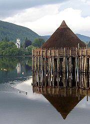
The Cairn Island
This was the only island on the loch and was thought as late as the 1860s to have been built by one of the lairds as a retreat for swans, geese, or other water fowl during the breeding season. It had a fordable causeway leading out to it and rose about 2.5 feet above the water level, clothed in trees and grasses. The southern end of the loch was the site of infill with slag and other wastes from 1841 onwards. By the 1860s 'The Cairn' had become distorted and shifted by the movement of the sediment on the loch caused by the weight of the infill, revealing the presence of a crannogCrannog
A crannog is typically a partially or entirely artificial island, usually built in lakes, rivers and estuarine waters of Scotland and Ireland. Crannogs were used as dwellings over five millennia from the European Neolithic Period, to as late as the 17th/early 18th century although in Scotland,...
lake dwelling (see 'Archaeology'). Infill operations completely destroyed then island in due course.
An artificial island was created at the south-east end of the loch for nesting birds in the 1980s.
Flax and steel
Lochside Farm was present on the north-west side of the loch in the 19th century, lying below and to the south-west of Lochrig, later Lochridge, as shown on the 19th century OS mapOrdnance Survey
Ordnance Survey , an executive agency and non-ministerial government department of the Government of the United Kingdom, is the national mapping agency for Great Britain, producing maps of Great Britain , and one of the world's largest producers of maps.The name reflects its creation together with...
; a 'Flax Pond' for rhetting flax
Flax
Flax is a member of the genus Linum in the family Linaceae. It is native to the region extending from the eastern Mediterranean to India and was probably first domesticated in the Fertile Crescent...
, as part of the process of linen manufacture, is also shown nearby on the loch bank; it is now visible as a wet area dominated by rushes. The firm of William & James Knox, linen thread manufacterers, established as early as 1788, are still based in Kilbirnie. Scotland was amongst the first producers of flax. The road running down to the loch here from Baxter Head became known locally as the 'Shanks-McEwan Road' after the company that was contracted to remove the old steelwork's slag heaps.
The Glengarnock Ironworks and the later steelworks produced slag and other wastes which were disposed of into the loch, significantly reducing its size and depth. The south-west section of the loch is still hazardous due to slag lying close to the surface. The Dubbs Water was originally dug as a canal in the late 18th century for transporting coal and iron ore to the steelworks and to take finished products to their markets. Roads were unsuitable for transport of heavy goods at the time and the railways were in their infancy.
Loch Riggs
This was a collier's hamlet near the Maich Water. The Loch Riggs Colliery was abandoned in 1808 when the works were flooded. The rich coal seams ran under the loch and were never further exploited. In 1900 the old colliery waste was encountered by the navvies during the construction of the railway between Lochwinnoch and Kilbirnie. A nearby road was locally known as the 'Back-Stair-Heid' and it has been suggested that this refers to the location of a pit ladderway used to carry coal out of the mines before winding engines were in use.Geology
The solid geology in the lower catchment area is carboniferous limestone. Higher ground to the North and South is mainly basaltBasalt
Basalt is a common extrusive volcanic rock. It is usually grey to black and fine-grained due to rapid cooling of lava at the surface of a planet. It may be porphyritic containing larger crystals in a fine matrix, or vesicular, or frothy scoria. Unweathered basalt is black or grey...
. The drift geology includes a layer of peat to the North and boulder clay and lake alluvium over the lower catchment zone. Soils are alluvium
Alluvium
Alluvium is loose, unconsolidated soil or sediments, eroded, deposited, and reshaped by water in some form in a non-marine setting. Alluvium is typically made up of a variety of materials, including fine particles of silt and clay and larger particles of sand and gravel...
to the North and Southeast, whilst to the East and West poorly drained non-calcareous gley
Gley
Gley may refer to:* Eugène Gley , French physiologist and endocrinologist* Gley soil, a type of hydric soil* Gley Lancer, a shoot 'em up game for Sega Mega Drive and Virtual Console...
soils predominate.
Archaeology
Crannog
A crannog is typically a partially or entirely artificial island, usually built in lakes, rivers and estuarine waters of Scotland and Ireland. Crannogs were used as dwellings over five millennia from the European Neolithic Period, to as late as the 17th/early 18th century although in Scotland,...
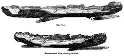
, its causeway and up to four logboats were revealed at the south-west corner of the loch as a result of dumping of furnace-slag from the now closed ironworks, causing the lake-bed sediments to be pushed upwards so that the crannog and logboat remains were exposed above the surface of the water. A site known as 'The Cairn' was already recognised, being exposed during exceptionally low water conditions. The crannog and causeway are marked on the 1st edition of the OS 6-inch map (Ayrshire, sheet viii) at NS 3238 5356.
Two of the boats were recorded in some detail. The most complete of the logboats was 18' (5.5m) in length, 3' (0.9m) in breadth and circa 2' (0.6m) in 'depth'; about 2' (0.6m) had been lost from the bow. The stern was 'square'. A tripod pit and a bronze ewer were found in one of the boats, now preserved at the Royal Museum of Scotland. These items were not contemporary with the logboat. The boat itself disintegrated rapidly on exposure to air. Part of a second logboat was subsequently found 'close by the island'; its fate is not recorded. This boat was worked from 'oak'.
In May 1952 part of a logboat was found on the west side of the loch and on the property of the Glengarnock Steelworks; slag-dumping operations were responsible for revealing it. Analysis of pollen from the mud found in the timber suggested that the logboat was from between about 3000 and 700bc. The surviving portion of the boat was donated to Paisley Museum.
The southern end of the loch was the site of infill with slag and other wastes from 1841 onwards, the greatest loss of open water being between 1859 and 1909. By 1930 the southern end infill had largely ceased, however infill from the west bank continued for some time.
Access
At the Beith end the unclassified 'Kerse' road runs between Beith and the A760 enables access to the northern shore of the loch. Parking along the roadside is difficult. At the railway bridge (NS 338 552) close to the old station is a rough track which leads down to the lochside and parking in this area is hazardous. The track and the area at the bottom are used by the local Kayak
Kayak
A kayak is a small, relatively narrow, human-powered boat primarily designed to be manually propelled by means of a double blade paddle.The traditional kayak has a covered deck and one or more cockpits, each seating one paddler...
Club. Access to the land along the north shore is dependent upon the good will of the landowner at Kerse Bridge Kennels.
Part of the Sustrans
Sustrans
Sustrans is a British charity to promote sustainable transport. The charity is currently working on a number of practical projects to encourage people to walk, cycle and use public transport, to give people the choice of "travelling in ways that benefit their health and the environment"...
National Route 7 runs close to the loch, starting at Paisley Canal railway station
Paisley Canal railway station
Paisley Canal railway station is a railway station in Paisley, Renfrewshire, Scotland. The station is managed by First ScotRail and lies on the Paisley Canal Line.-History:...
and following the same route as National Route 75 until Johnstone, passing Elderslie
Elderslie
Elderslie is a village in the council area and historic county of Renfrewshire in the west central Lowlands of Scotland. The village is situated midway between the nearby towns of Paisley and Johnstone....
and continuing south-west to Kilbarchan
Kilbarchan
Kilbarchan is a village and civil parish in central Renfrewshire, in the west central Lowlands of Scotland. The village's name means "cell of St. Barchan". It is known for its former weaving industry.- History :...
, Lochwinnoch
Lochwinnoch
Lochwinnoch is a village in the council area and historic county of Renfrewshire in the west central Lowlands of Scotland. Lying on the banks of Castle Semple Loch and the River Calder, Lochwinnoch is chiefly a residential dormitory village serving nearby urban centres such as Glasgow and Paisley...
and Kilbirnie, passing by Castle Semple, Barr as well as Kilbirnie Loch. Cycle paths runs on down via Glengarnock, Dalgarven
Dalgarven
The tiny village of Dalgarven in North Ayrshire, Scotland is located just north of Kilwinning on the road to Dalry.In 1881 some two hundred people lived in the village, the mill being at its heart, with a Sunday school, smithy, joiner's shop and Dalgarven House. Most of the women were weavers,...
and Kilwinning to Ardrossan, Irvine and beyond.
Transport
The loch was used for pleasure cruises in the 18th century and coal was once carried from the Kilbirnie side across the loch to Beith. Hugh Stevenson used to have the "sole right to howk coal in Brodie's Glen" up the Maich Water. Hugh Stevenson transported the coal down to the loch, and ferried it across to a jetty which was near the mouth of the Mains Burn, then locally known as the Back Burn, and from there it was taken up to Beith by cart.A passenger ferry also ran across the loch at one time, most likely from near the old Lochside Farm, which is reached by a lane from Stonyholm, across to the Bark Mills delta
River delta
A delta is a landform that is formed at the mouth of a river where that river flows into an ocean, sea, estuary, lake, reservoir, flat arid area, or another river. Deltas are formed from the deposition of the sediment carried by the river as the flow leaves the mouth of the river...
where the silt from the mains burn has encroached into the loch and a small jetty existed. The old Beith Mid Road then led up into the town itself.
Natural history
Castle Semple and Barr Lochs are SSSIs and Kilbirnie Loch is a Scottish Wildlife Trust
Scottish Wildlife Trust
The Scottish Wildlife Trust is a registered charity dedicated to conserving the wildlife and natural environment of Scotland.-Description:The Scottish Wildlife Trust has over 32,800 members...
designated LSNC (Local Site for Nature Conservation) in terms of the Ayrshire Local Biodiversity Action Plan (ALBAP) and in partnership with North Ayrshire Council. High levels of invasive alien waterweed species, Canadian waterweed (Elodea canadensis) and Nuttall’s waterweed (Elodea nuttalli) if left unchecked, will continue to spread and overwhelm other native aquatic plants. The loch's southern end is dominated by large areas of mown grass with mature grown bushes and wood copses. The western shore for the first 0.75 km or so is composed of planted Willow with some older deciduous trees; round the loch into the very north-east corner, pastures surround the loch. Along the western part, the ground slopes quite steeply down to the loch. The northern shore itself is level and there are areas of marshy ground. The eastern side of the loch is a narrow strip of reedbed and bogbean grows in sheltered area.
The Mains and Willowyard burns feed the loch from the eastern side and the Black Burn enters from the north-west; both have brought in silt that has created the areas of reedbeds. In addition to the Dubbs Water, a small burn, now piped, drains into the loch at the southern end.
The dominant plant of the waters edge is reed canary grass running from the East round to the South and into the West side. Creeping bent, reed sweet grass and iris are abundant. Common water-crowfoot, Chara
Chara
-Geography:*Chara , a rural locality in Zabaykalsky Krai, Russia*Chara Airport located there*Chara River, a river in Russia-Science:*Chara , a genus of algae in the family Characeae...
species, Canadian waterweed, slender spike-rush, perfoliate pondweed and spiked water milfoil are the other main species present.
The diatom
Diatom
Diatoms are a major group of algae, and are one of the most common types of phytoplankton. Most diatoms are unicellular, although they can exist as colonies in the shape of filaments or ribbons , fans , zigzags , or stellate colonies . Diatoms are producers within the food chain...
s species Capucina and Asterionella
Asterionella
Asterionella is a genus of pennate freshwater diatoms. They are frequently found in star shaped colonies of individuals.- Description :Asterionella average cell size is 60-80 micrometer long and 2-4 micrometer wide....
have been recorded, together with blue-green algae, Copepods, and some Rotifer
Rotifer
The rotifers make up a phylum of microscopic and near-microscopic pseudocoelomate animals. They were first described by Rev. John Harris in 1696, and other forms were described by Anton van Leeuwenhoek in 1703...
s. Oligochaete worms, snails, freshwater louse, leeches, mayflies, caddisfly larvae, beetles, Chironomid larvae, 6-spotted burnet moth, green-veined white, common blue, blue damsel fy, are all present.
Rare species
Surveys have identified the following rare species : Reed grass (Glyceria maximaGlyceria maxima
Glyceria maxima Holmb. is a species of rhizomatous perennial grasses in the mannagrass genus native to Europe and Western Siberia and growing in wet areas such as riverbanks and ponds...
); Carex aquatilis
Carex aquatilis
Carex aquatilis is a species of sedge known by the common names water sedge and leafy tussock sedge. It has a circumboreal distribution, occurring throughout the northern reaches of the Northern Hemisphere. It grows in many types of mountainous and Arctic habitat, including temperate coniferous...
; Viper's bugloss (Echium vulgare); Marestail (Hippuris vulgaris); Field scabious (Knautia arvensis
Knautia arvensis
Knautia arvensis, commonly known as Field Scabious, is a species in the genus Knautia.It is a perennial plant that grows between 25 and 100 cm. It prefers grassy places and dry soils, avoiding heavy soils, and flowers between July and September. The flowered head is flatter than similar...
); Spiked water-milfoil (Myriophyllum spicatum
Myriophyllum spicatum
Myriophyllum spicatum is a species of Myriophyllum native to Europe, Asia, and north Africa. It is a submerged aquatic plant, and grows in still or slow-moving water.-Description:...
); Shoreweed (Littorella uniflora); Butterfly orchid (Platanthera chlorantha
Platanthera chlorantha
Platanthera chlorantha, commonly known as the Greater Butterfly-orchid, is a species of orchid in the genus Platanthera. It can be found throughout Europe and Morocco. The name Platanthera is derived from Greek, meaning "broad anthers", while the species name, chlorantha, means "greenflowered".The...
); Ivy-leaved crowfoot (Ranunculus hederaceus); Weld (Reseda luteola
Reseda luteola
Reseda luteola is a plant species in the genus Reseda. Common names include dyer's rocket, dyer's weed, weld, woold, and yellow weed...
); Marsh yellow-cress (Rorippa islandica); Bay willow (Salix pentandra); Creeping yellow-cress (Rorippa sylvestris
Rorippa sylvestris
Rorippa sylvestris is an invasive species ) in the United States....
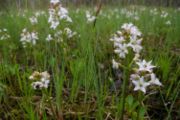
); and the relatively rare plant, Bogbean (Menyanthes trifoliata), that grows in sheltered areas on the west bank of the loch.
Activities on the loch
A number of groups use the loch and its surrounds, such as the Kilbirnie Angling Club, Garnock Canoe and Boating Club, Kyle Water Ski Club, the Model Boat Club, Garnock Rugby Club, and the Garnock Valley Model Aircraft Club.Curling
Broadstone, North Ayrshire
Broadstone lies close to the small village of Gateside in North Ayrshire, Scotland about half a mile east of Beith in the old Barony of Giffen.-The castle:The ruins of Braidstone or Broadstone Castle remained until about 1850...
. A large number of spectators were present. A Bonspiel
Bonspiel
A bonspiel is a curling tournament, traditionally held outdoors on a frozen freshwater loch. The word comes from the Scottish Gaelic and means league match . Though not mandatory, curling teams involved in bonspiels often wear theme costumes...
took place at the nearby Barr Loch on 11 January 1850 and attracted huge crowds. The North won for the first time by a majority of 233 shots. The Curling Stone manufacturer, J & W Muir, were at one time based in Beith
Beith
Beith is a small town situated in the Garnock Valley in North Ayrshire, Scotland approximately 20-miles south-west of Glasgow. The town is situated on the crest of a hill and was known originally as the "Hill o' Beith" after its Court Hill.-History:-Name:Beith's name is thought to emanate from...
.
'The History of Curling. 1800-1833' records that 'In Beith there were then, as there are now, many keen and good curlers who flocked down to Kilbirnie when the "icy chain' was safely thrown over it.
Angling
Kilbirnie is well known as a fishing loch with big pike and large stocks of roach, plus rainbow and brown trout; boat and bank fishing take place. In 2009 a 30 lb plus pike was caught in the loch. The Kilbirnie Angling Club was founded in 1904 when it fished Kilbirnie Loch and the Plan Dam. In 1934 the club began fishing the Dubbs Water and now leases the Maich Water, Kilbirnie Loch, the Barr Loch, and the Dubbs Water from the Crown Estates. The loch is stocked with rainbow trout.Circa 1604 it is recorded by Timothy Pont
Timothy Pont
Timothy Pont was a Scottish topographer, the first to produce a detailed map of Scotland. Pont's maps are among the earliest surviving to show a European country in minute detail, from an actual survey.-Life:...
that Loch of Killburney it is ye goodliest frech vatter in all Cuninghame and in 1641 Sir John Crawfurd was ratified as holding the fishing rights. In 1876 it is recorded as being well stored with pike, trout, perch, braize (bream) and eels.
Bird watching
Late autumn through winter are the times of greatest interest. Mallard, Tufted Duck, Coot and Mute Swan are present throughout the year, but it is towards the end of September before numbers and species begin to increase. Tufted Duck, Goldeneye, Wigeon, Teal and possibly Goosander with sometimes Smew and Scaup. Cormorant are frequent, with Grey Heron feeding along the banks, and several gull species. It has been noted that waterfowl prefer the northern reaches of the loch. The reedbed habitats are confined and not large enough for marsh specialists, although Sedge Warbler and Reed Bunting are probably present.The Willow plantations, other deciduous species and scrub on the western slopes provide cover for Great Spotted Woodpecker, tits, thrushes, finches, and warblers and other passerines. The north-eastern corner and the north shore provide shallower, marshier habitats where waders such as Common Snipe, Redshank, and Curlew. The hawthorn and other tree cover in this area create cover and feeding for finches, tits, and thrushes, prey for Sparrowhawks. A Great Grey Shrike was seen here in December 2001. Historical records include Storm and Leach's Petrel, Ruff, Puffin and Kittiwake in the period 1889 to 1915. The loch is a Wetland Birds Survey (WeBS) site and total count results are available on the WeBS site.
Water skiing
Kyle Waterski Club has been active on the loch for around 30 years. The clubhouse is based at the Southern end of the loch where there is a car park, slipway and a short jetty as well as the club's changing facilities. Kyle WSC is affiliated to both the British Waterski & Wakeboard Federation (BWSW) and Waterski Scotland.The club has a tournament standard slalom course and uses a Nautique 196 ski boat. It is open for skiing from 1 April to 30 September on Monday, Wednesday and Friday evenings and also on Saturday and Sunday afternoons.
Garnock Rugby Football Club
Garnock Rugby ClubGarnock RFC
Garnock Rugby Club is an amateur rugby union club based in Glengarnock in Scotland. They currently play in the Scottish National League Division One.-History:...
plays on the Lochshore Playing fields, what was part of the old loch area, infilled by the iron and steelworks in the 19th century. The club is an amateur rugby union
Rugby union
Rugby union, often simply referred to as rugby, is a full contact team sport which originated in England in the early 19th century. One of the two codes of rugby football, it is based on running with the ball in hand...
club and currently plays in the Scottish National League Division 1. The club was formed in 1972 as the result of a merger of the Old Spierians and Dalry High School FP clubs. This was a response to the amalgamation of feeder schools Spier's and Dalry High (along with Kilbirnie Central and Beith Academy) to form Garnock Academy, which happened around the same time. The Old Spierians club had been founded in the early years of the 20th century and joined the Scottish Rugby Union
Scottish Rugby Union
The Scottish Rugby Union is the governing body of rugby union in Scotland. It is the second oldest Rugby Union, having been founded in 1873, as the Scottish Football Union.-History:...
in 1911.
Handkea exipuliformis
The Pestle puffball fungus (Handkea exipuliformis) grows at the edge of the mainly birch scrub area. This large puffball fungus releases its spores by the decay of the head portion, leaving a pestle-like stem that persists through to the following summer.
Water quality
The loch has had spoil, effluent and other pollutants discharged into it when the Glengarnock Iron and then Steel Works were operational; the remaining slag in the loch is relatively rich in phosphates which exacerbates the pollution problems. In the 1990s the loch become eutrophic as a result of high levels of nutrient input which has sometimes resulted in algal blooms in the summer, counteracted by bales of barley straw. These algal blooms can be dangerous to both humans and dogs. The source of this input has not been clearly tracked down, however a reedbed may be established to act as a filtration system. The loch is rather poor in terms of invertebrate faunal diversity under its present conditions, not helped by the invasive pondweeds, such as Canadian Pondweed.Clyde Muirshiel Regional Park Authority
Clyde Muirshiel Regional Park Authority are not directly involved in the management of Kilbirnie Loch, it does however lie within the regional parks extended boundary. The park authority has in the past initiated discussions with a number of partners including Scottish Natural Heritage, the Scottish Environment Protection Agency (SEPA), RSPB, etc. with ‘A Shared Vision’ for the ‘Three Lochs’. These partners continue to develop options for the potential future management of this important wetland system.The Willowyard estate
On the east side of the loch lie the ancient lands of Willowyard, locally pronounced 'Williyard', and the various Mains dwellings associated with it. In 1559 Hugh Montgomery of Hessilhead held the lands of old extent of Williyard, in the parish of Beith and regality of Kilwinning. These lands were passed to Helen, daughter of Robert Lord Boyd, in her pure, spotless, and inviolate virginity and were held by her for life, the feu for the property passing to the abbot and convent of Kilwinning. Blaeu's map of Timothy PontTimothy Pont
Timothy Pont was a Scottish topographer, the first to produce a detailed map of Scotland. Pont's maps are among the earliest surviving to show a European country in minute detail, from an actual survey.-Life:...
's survey marks the property as 'Williezeards'.
The surviving Willowyard House dates from 1727 as `727J' or `Z27J' is carved on the exterior of the house. Circa 1750 a William Simson is recorded as the owner. By the end of the 18th century Willowyards was a well established farmstead and the Edinburgh Advertiser describes it as: consisting of about 175 English acres of arable land, well enclosed and subdivided into fifteen fields, and let by one lease to three substantial tenants for 19 years at £130 per annum. Upon this property there is a good house, and garden stocked with fruit trees, a malt mill and an elegant court of offices newly erected. A valuable flag and stone quarry has been opened in the ground and it is believed there are both coal and limestone in it. There are about ten acres of wood and a good deal of timber on this farm; and thriving belts of planting surround the greatest part of it.
In 1820 Willowyard is recorded as being an estate of 120 acres, well planted up by the owner with belts of plantings and the fine house situated in full view of the loch. The estate sits on whinstone and a small quarry nearby became an ornamental lake. In 1820 John Neil Esq of Edinburgh was the owner, however by 1822 the owner of Willowyard is recorded as being Robert Steele, a Port Glasgow
Port Glasgow
Port Glasgow is the second largest town in the Inverclyde council area of Scotland. The population according to the 1991 census for Port Glasgow was 19426 persons and in the 2001 census was 16617 persons...
ironmaster and the lands were assessed as the 14th most valuable in the parish at £114 per year valued rent. The 1827 map by Aitken marks the estate as being the property of Robert Steel Esq. In the New Statistical Account, William Wilson, a maternal descendent of previous owners purchaded the estate in 1832 and in 1839 Alexander Shedden is noted as the owner.
The Willowyard Industrial Estate is situated between Kilbirnie loch and the town of Beith. A large whisky bond is located in the area with a number of large storage buildings and Willowyard House still stands, converted into offices serving a chemicals company. The rubble walls of the building were harled and the window and angle margins left as exposed dressed stone; the roof was thatched originally. The main railway line from Ayr to Glasgow runs below the industrial estate and forms the eastern margin of the loch in places.
Mains
The properties named 'Mains' became divided up into 'Mains-Neil', 'Mains-Houston', and 'Mains-Marshal'. Robertson records that Mains-Hamilton was recently (1820) converted into a good looking house by Mr. Dun, however it passed to a Mr. Houston. A farmhouse is shown marked as Mains Hamilton on the OS map of 1856 together with an L-plan outbuilding, which may now form part of the former coachhouse at 'The Meadows' on Arran Crescent. The farmhouse was demolished and the villa built on the site, perhaps utilising the existing whinstone. Blaeu's map of Timothy PontTimothy Pont
Timothy Pont was a Scottish topographer, the first to produce a detailed map of Scotland. Pont's maps are among the earliest surviving to show a European country in minute detail, from an actual survey.-Life:...
's survey of circa 1600 marks the properties of Mains Mure, Mainshill, and Mains neil, with Mains Mure as a castleated tower house.
The 1911 OS map refers to Mains Lodge as 'Muir Lodge' after William Muir who built Mains House. The Muir family owned the Bath Lane Tannery, near the Beith Health centre of today (2011) and built the Bark Mill. William Muir of Mains joined John Muir and Sons, Tanners, Curriers, and Fancy Leather Manufacturers as a partner in 1846. Laigh Mains, also demolished, was the home farm of Mains House. Dr McCusker, a GP based in Glasgow, owned Mains House at the time of WW2, followed by Mr Dewar, prior to its purchase and demolition which resulted from the establishment of Whisky Bonds here by Ballantyne Whisky Company in 1968, following the disaster of the Cheapside Street Whisky Bond Fire
Cheapside Street Whisky Bond Fire
The Cheapside Street Whisky Bond Fire in Glasgow on 28 March 1960 is Britain's worst peacetime fire services disaster.-Fire:On the evening of 28 March 1960 a fire broke out in a bonded warehouse owned by Arbuckle, Smith and Company in Cheapside Street, Anderston, Glasgow.The Glasgow Fire Service...
. There were engraved stones with the initials of Mr and Mrs Muir on the Mains House and these were saved when the house was demolished circa 1975 and now form part of a garden within the grounds of the bonded area. Davis records that the original single storey house of 1764 with its attic were used as aservice wing to the crow stepped house had the appearnce of a double version of the lodge house.
Mid Road used to cross the Bath Burn by a ford near Mains House and then ran up to the town; the road has now been abandoned and is only used by intrepid walkers.
Bark Mill
A Bark Mill, most likely built by the Muirs of Mains House, is marked on OS maps, powered by the combined Mains and Bath Burns with mill ponds indicated. The mill produced ground bark for use in the Beith tanneries using bark from the old oak trees that forested the loch side. Later the mill became a furniture factory run by Matthew Pollock who applied the use of machinery to help with the manufacture of furniture in 1858. This site was one mile from the Beith town centre. The Glasgow & South Western Railway Company constructed a siding, known as 'Muir's siding' for the convenience of transporting the finished products, etc. However the site was isolated and incovenient for the workers and was eventually sold to Robert Balfour, who later built a new factory near Beith Town StationBeith Town railway station
Beith Town railway station was a railway station serving the town of Beith, North Ayrshire, Scotland. The station was originally part of the Glasgow, Barrhead and Kilmarnock Joint Railway.- History :...
, the West of Scotland Cabinet Works. The Muirs had been tanners for many generations and around 1791 John Muir and Sons, Tanners, Curriers, and Fancy Leather Manufacturers had become established at the Bath Lane works. William Muir of Mains joined as a partner in 1846.
Micro-history
An early Bronze Age flanged axehead was found near East Kerse in 2004 by a metal detectorist and is now in the Kelvingrove Museum, Glasgow. The axehead belongs to the so-called Bandon type with a long, straight-sided body, raised edges or low flanges and widely expanded blades. The find is associated at this site with several other finds of metalwork of the later Early Bronze Age.One of the buildings at the Kerse Bridge was the old 'Kirk's Railway Inn' serving the railway station that once stood across the road from it. Mrs Kirk managed the Railway Inn at the turn of the 20th century Alexander Kirk spent his boyhood years there, attended Spier's school and served in France from 1917, graduated in medicine at Glasgow university and spent his professional life in England. A small pier existed at the north end of the loch in recent times.
Much of the successful drainage works, especially of the Barr Loch, were carried out by Dutch immigrants who introduced the technology from their homeland; Dutch surnames present in the area to this day reflect this immigration. In around 1691 the Rev Patrick Warner likewise purchased and drained much of the Irving Loch or Trindlemoss, later called Scott's Loch, after returning from exile in Holland.
The Ardrossan & Saltcoats Herald recorded that in 1904-05 a model yacht race under the auspices of Townhead Model Yacht Club on Kilbirnie Loch the result was: 1, John Martin, jun (Thistle); 2, James Martin (Swift); 3, John Martin (Helena); 4, William McCosh (Reliance)); 5, William Taylor (Genesta); 6, John Taylor (Bona); 7, Robert Taylor (Rover); 8, Robert Martin (Fairlie).
A possible relic of the smuggling days of Beith is the Ley tunnel
Ley tunnel
Ley tunnels are a common element of the local folklore tradition in the United Kingdom and they also occur in Europe. In Norwegian a ley tunnel-like passage is called a "lønngang" and in Swedish a "lönngång"...
that is said to run from the site of the Grace Church on Eglinton Street to Kilbirnie Loch.
A geocache
Geocaching
Geocaching is an outdoor sporting activity in which the participants use a Global Positioning System receiver or mobile device and other navigational techniques to hide and seek containers, called "geocaches" or "caches", anywhere in the world....
is located on the lochside. Kilbirnie Loch is said to be the only Scottish loch to have its main exit at the same end as the source river.
Scottish Enterprise owns much of the former steelworks site, tree plantations now cover areas of former industral activity.
The Earl of Eglinton
Earl of Eglinton
Earl of Eglinton is a title in the Peerage of Scotland.Some authorities spell the title: Earl of Eglintoun In 1859 the thirteenth Earl of Eglinton, Archibald Montgomerie, was also created Earl of Winton in the Peerage of the United Kingdom, which gave him an automatic seat in the House of Lords,...
had proposed building a canal from Ardrossan to Glasgow which would have run close by to Kilbirnie Loch.
The North Ayrshire Council Ranger Service
Eglinton Country Park
Eglinton Country Park is located in the grounds of the old Eglinton Castle estate, Kilwinning, North Ayrshire, Scotland . Eglinton Park is situated in the parish of Kilwinning, part of the former district of Cunninghame, and covers an area of 400 hectares...
regularly patrols the loch and work with the Kilbirnie Loch Management Group to licence boats using the loch, monitor fishing, canoeing, sailing, and power boat use. The use of the loch is regulated by Scottish Countryside Access legislation.