
Kesennuma, Miyagi
Encyclopedia
is a city
located in the extreme northeast of Miyagi Prefecture
, Japan, founded on June 1, 1953. It wraps around the western part of Kesennuma Bay, and also includes the island of Ōshima. Its coastline forms the southern boundary of the Rias Coastline National Park, which stretches north all the way to Aomori Prefecture
.
The city borders Hirota Bay, Kesennuma Bay, and the Pacific Ocean
to the east and Minamisanriku, Miyagi
to the south. Iwate Prefecture
makes up the remainder of its borders, with Murone Village
to the west, and Rikuzen-Takata City
to the north. The highest point in Kesennuma is 711.9 m high, on the border with Motoyoshi
, while the lowest point is at sea level.
Large sections of the city were destroyed by the 2011 Tōhoku earthquake and tsunami
and major fires on March 11, 2011.
and Motoyoshi
.
Until recent times, the city was Japan's busiest port for processing bonito
and swordfish
. Presently, fishing and associated industries account for 85% of jobs in the town.
On March 11, 2011, large parts of the city were destroyed by the tsunami
which followed the Tōhoku earthquake
. The island of Oshima and its 3,000 residents, included in the city limits, were isolated by the tsunami which damaged the ferry connections. After the tsunami, spilled fuel from the town's fishing fleet caught fire and burned for four days. As of 22 April 2011, the city had confirmed 837 deaths with 1,196 missing.
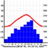
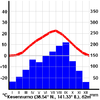 Kesennuma is situated in a temperate climate zone and has a moderate climate. The city's average temperature is 10.8°C (53.8°F) and its average annual precipitation is 1,370.6 mm. Its all-time record high is 36.0°C on August 15, 1994, and its all-time record low is -12.6°C on February 17, 1980. The city's climate is fairly similar to Sendai
, the largest city in Miyagi Prefecture
. Since Kesennuma is located north of Sendai, it is naturally slightly cooler. However, Kesennuma is known to be fairly warm for a city located at its latitude, largely because of ocean currents that flow close by.
Zhoushan
, People's Republic of China
Friendship relation with Ports of Kesennuma and Seattle, Washington, United States
and commercial fishing
, the latter being what the city is known for, especially its tuna
, pacific saury
and skipjack tuna
production, keeping the fishing port very active. It also has a shark fin
fishery.
Cities of Japan
||A is a local administrative unit in Japan. Cities are ranked on the same level as and , with the difference that they are not a component of...
located in the extreme northeast of Miyagi Prefecture
Miyagi Prefecture
is a prefecture of Japan in the Tōhoku Region on Honshu island. The capital is Sendai.- History :Miyagi Prefecture was formerly part of the province of Mutsu. Mutsu Province, on northern Honshu, was one of the last provinces to be formed as land was taken from the indigenous Emishi, and became the...
, Japan, founded on June 1, 1953. It wraps around the western part of Kesennuma Bay, and also includes the island of Ōshima. Its coastline forms the southern boundary of the Rias Coastline National Park, which stretches north all the way to Aomori Prefecture
Aomori Prefecture
is a prefecture of Japan located in the Tōhoku Region. The capital is the city of Aomori.- History :Until the Meiji Restoration, the area of Aomori prefecture was known as Mutsu Province....
.
The city borders Hirota Bay, Kesennuma Bay, and the Pacific Ocean
Pacific Ocean
The Pacific Ocean is the largest of the Earth's oceanic divisions. It extends from the Arctic in the north to the Southern Ocean in the south, bounded by Asia and Australia in the west, and the Americas in the east.At 165.2 million square kilometres in area, this largest division of the World...
to the east and Minamisanriku, Miyagi
Minamisanriku, Miyagi
, also spelled Minami Sanriku, is a resort town on a coastline of wooded islands and mountainous inlets. The town is in Motoyoshi District, Miyagi, Japan. It has an area of , and as of October 1, 2004 the population of the area was 19,170...
to the south. Iwate Prefecture
Iwate Prefecture
is the second largest prefecture of Japan after Hokkaido. It is located in the Tōhoku region of Honshū island and contains the island's easternmost point. The capital is Morioka. Iwate has the lowest population density of any prefecture outside Hokkaido...
makes up the remainder of its borders, with Murone Village
Murone, Iwate
Murone was a village located in Higashiiwai District, Iwate, Japan.On September 20, 2005 Murone, along with the towns of Daitō, Higashiyama and Senmaya, the village of Kawasaki, all from Higashiiwai District, and the town of Hanaizumi, from Nishiiwai District, was merged into the expanded city of...
to the west, and Rikuzen-Takata City
Rikuzentakata, Iwate
is a city in Iwate, Japan.In the quinquennial census of 2010, the city had a population of 23,302 . With a total area of 232.29 km² the density is 100 persons per km². The city was founded on January 1, 1955. The 2011 Tōhoku earthquake and tsunami caused extensive damage to the city.- Politics...
to the north. The highest point in Kesennuma is 711.9 m high, on the border with Motoyoshi
Motoyoshi, Miyagi
was a town located in Motoyoshi District, Miyagi, Japan.In 2003, the town had an estimated population of 11,716 and a population density of 109.80 persons per km². The total area was 106.70 km². Motoyoshi was divided into four districts: Magome, Koizumi, Tsuya, and Ohya. Koizumi and Ohya were both...
, while the lowest point is at sea level.
Large sections of the city were destroyed by the 2011 Tōhoku earthquake and tsunami
2011 Tōhoku earthquake and tsunami
The 2011 earthquake off the Pacific coast of Tohoku, also known as the 2011 Tohoku earthquake, or the Great East Japan Earthquake, was a magnitude 9.0 undersea megathrust earthquake off the coast of Japan that occurred at 14:46 JST on Friday, 11 March 2011, with the epicenter approximately east...
and major fires on March 11, 2011.
History
Kesennuma City was formed on June 1, 1953, when Kesennuma Town, Shishiori Village, and Matsuiwa Village were merged. It grew in size on April 1, 1955, when Niitsuki Village, Hashikami Village, and Oshima Village were annexed, and again in 2006 and 2009 with the incorporation of KarakuwaKarakuwa, Miyagi
was a town located in the extreme northeast of Miyagi Prefecture, bordering Kesennuma to the north-west and Rikuzentakata, part of Iwate Prefecture, to the north, and with Kesennuma Bay including Oshima island to the west, Hirota Bay to the north-east, and the Pacific Ocean to the south and east.On...
and Motoyoshi
Motoyoshi, Miyagi
was a town located in Motoyoshi District, Miyagi, Japan.In 2003, the town had an estimated population of 11,716 and a population density of 109.80 persons per km². The total area was 106.70 km². Motoyoshi was divided into four districts: Magome, Koizumi, Tsuya, and Ohya. Koizumi and Ohya were both...
.
Until recent times, the city was Japan's busiest port for processing bonito
Bonito
Bonito is a name given to various species of medium-sized, predatory fish in the Scombridae family. First, bonito most commonly refers to species in the genus Sarda, including the Atlantic bonito and the Pacific bonito ; second, in Japanese cuisine, bonito refers to the skipjack tuna , which, in...
and swordfish
Swordfish
Swordfish , also known as broadbill in some countries, are large, highly migratory, predatory fish characterized by a long, flat bill. They are a popular sport fish of the billfish category, though elusive. Swordfish are elongated, round-bodied, and lose all teeth and scales by adulthood...
. Presently, fishing and associated industries account for 85% of jobs in the town.
On March 11, 2011, large parts of the city were destroyed by the tsunami
Tsunami
A tsunami is a series of water waves caused by the displacement of a large volume of a body of water, typically an ocean or a large lake...
which followed the Tōhoku earthquake
2011 Tōhoku earthquake and tsunami
The 2011 earthquake off the Pacific coast of Tohoku, also known as the 2011 Tohoku earthquake, or the Great East Japan Earthquake, was a magnitude 9.0 undersea megathrust earthquake off the coast of Japan that occurred at 14:46 JST on Friday, 11 March 2011, with the epicenter approximately east...
. The island of Oshima and its 3,000 residents, included in the city limits, were isolated by the tsunami which damaged the ferry connections. After the tsunami, spilled fuel from the town's fishing fleet caught fire and burned for four days. As of 22 April 2011, the city had confirmed 837 deaths with 1,196 missing.
Climate
Sendai, Miyagi
is the capital city of Miyagi Prefecture, Japan, and the largest city in the Tōhoku Region. In 2005, the city had a population of one million, and was one of Japan's 19 designated cities...
, the largest city in Miyagi Prefecture
Miyagi Prefecture
is a prefecture of Japan in the Tōhoku Region on Honshu island. The capital is Sendai.- History :Miyagi Prefecture was formerly part of the province of Mutsu. Mutsu Province, on northern Honshu, was one of the last provinces to be formed as land was taken from the indigenous Emishi, and became the...
. Since Kesennuma is located north of Sendai, it is naturally slightly cooler. However, Kesennuma is known to be fairly warm for a city located at its latitude, largely because of ocean currents that flow close by.
International Sister / Friendship Cities
Puntarenas, Costa RicaPuntarenas
Puntarenas is the capital and largest city in the province Puntarenas, Costa Rica, at the Pacific coast. The eponymous and oddly shaped province has its largest section in the South, far from the capital.Some 100,000 live in the city and close towns...
Zhoushan
Zhoushan
Zhoushan or Zhoushan Archipelago New Area; formerly transliterated as Chusan, is a prefecture-level city in northeastern Zhejiang province of Eastern China. The only prefecture-level city of the People's Republic of China consisting solely of islands, it lies across the mouth of the Hangzhou Bay,...
, People's Republic of China
People's Republic of China
China , officially the People's Republic of China , is the most populous country in the world, with over 1.3 billion citizens. Located in East Asia, the country covers approximately 9.6 million square kilometres...
Friendship relation with Ports of Kesennuma and Seattle, Washington, United States
Seattle, Washington
Seattle is the county seat of King County, Washington. With 608,660 residents as of the 2010 Census, Seattle is the largest city in the Northwestern United States. The Seattle metropolitan area of about 3.4 million inhabitants is the 15th largest metropolitan area in the country...
Industry
Kesennuma relies on tourismTourism
Tourism is travel for recreational, leisure or business purposes. The World Tourism Organization defines tourists as people "traveling to and staying in places outside their usual environment for not more than one consecutive year for leisure, business and other purposes".Tourism has become a...
and commercial fishing
Commercial fishing
Commercial fishing is the activity of catching fish and other seafood for commercial profit, mostly from wild fisheries. It provides a large quantity of food to many countries around the world, but those who practice it as an industry must often pursue fish far into the ocean under adverse conditions...
, the latter being what the city is known for, especially its tuna
Tuna
Tuna is a salt water fish from the family Scombridae, mostly in the genus Thunnus. Tuna are fast swimmers, and some species are capable of speeds of . Unlike most fish, which have white flesh, the muscle tissue of tuna ranges from pink to dark red. The red coloration derives from myoglobin, an...
, pacific saury
Pacific saury
The Pacific saury, Cololabis saira, is a member of the family Scomberesocidae. This saury, which is a food source in some East Asian cuisines, is also known by the name mackerel pike.- Name :...
and skipjack tuna
Skipjack tuna
The skipjack tuna, Katsuwonus pelamis, is a medium-sized perciform fish in the tuna family, Scombridae. It is otherwise known as the aku, arctic bonito, mushmouth, oceanic bonito, striped tuna, or victor fish...
production, keeping the fishing port very active. It also has a shark fin
Shark Fin
Shark Fin is the peak which has the triangular shape of a shark fin when viewed from the south....
fishery.
Education
Kesennuma, as the largest center in northeast Miyagi, is an education center for high school, featuring five of them. It also has eight junior high schools and fourteen elementary schools.Train stations
- Kesennuma LineKesennuma LineThe is a local rail line in Japan. Part of the East Japan Railway Company system, it runs from Maeyachi Station in Ishinomaki, Miyagi to Kesennuma Station in Kesennuma, Miyagi...
: KurauchiKurauchi StationKurauchi Station is located on the JR Kesennuma Line in Kesennuma, Miyagi.It was damaged by the 2011 Japanese tsunami.- External links : video of a train trip from Motoyoshi Station to Utatsu Station in 2009, passing through Rikuzen-Koizumi Station, Kurauchi Station, and Rikuzen-Minato Station...
- Rikuzen-KoizumiRikuzen-Koizumi StationRikuzen-Koizumi Station is located on the JR Kesennuma Line in Kesennuma, Miyagi.It was destroyed by the 2011 Japanese tsunami.- External links : video of a train trip from Motoyoshi Station to Utatsu Station in 2009, passing through Rikuzen-Koizumi Station, Kurauchi Station, and Rikuzen-Minato...
- MotoyoshiMotoyoshi StationMotoyoshi Station is located on the JR Kesennuma Line in Kesennuma, Miyagi.It was undamaged by the 2011 Japanese tsunami.-Surrounding area:*Highway 346*National Health Insurance Hospital*Kesennuma City East Branch Office...
- KoganezawaKoganezawa StationKoganezawa Station is located on the JR Kesennuma Line in Kesennuma, Miyagi.It was damaged by the 2011 Japanese tsunami.- External links : video of a train trip from Rikuzen-Hashikami Station to Motoyoshi Station in 2009, passing through Ōya-Kaigan Station and Koganezawa Station without stopping...
- Ōya-KaiganOya-Kaigan StationŌya-Kaigan Station is located on the JR Kesennuma Line in Kesennuma, Miyagi.It was badly damaged or destroyed by the 2011 Japanese tsunami.-History:*February 11, 1957: Station begins operation as Ōya Station....
- Rikuzen-HashikamiRikuzen-Hashikami Stationis located on the JR Kesennuma Line in Kesennuma, Miyagi.It was undamaged by the 2011 Japanese tsunami.- External links : video of a train trip from Minami-Kesennuma Station to Rikuzen-Hashikami Station in 2009, passing through Matsuiwa Station and Saichi Station without stopping at around 03:05...
- SaichiSaichi StationSaichi Station is located on the JR Kesennuma Line in Kesennuma, Miyagi.It was badly damaged or destroyed in the 2011 Japanese tsunami....
- MatsuiwaMatsuiwa StationMatsuiwa Station is located on the JR Kesennuma Line in Kesennuma, Miyagi.It was badly damaged or destroyed in the 2011 Japanese tsunami....
- Minami-KesennumaMinami-Kesennuma StationMinami-Kesennuma Station is located on the JR Kesennuma Line in Kesennuma, Miyagi, Japan.It is the rapid express "Minami-Sanriku" stop station for Sendai.Minami-Kesennuma Station was almost completely destroyed in the 2011 Japanese tsunami....
- FudōnosawaFudonosawa StationFudōnosawa Station is located on the JR Kesennuma Line in Kesennuma, Miyagi.The station was undamaged in the 2011 Japanese tsunami....
- KesennumaKesennuma StationKesennuma Station is a train station in central Kesennuma, Miyagi, Japan. It forms the junction of the JR East Ōfunato and Kesennuma lines... - Ōfunato LineOfunato LineThe is a local rail line in Japan. Part of the East Japan Railway Company system, it runs as a spur line from Ichinoseki Station in Ichinoseki, Iwate, in central Japan to Sakari Station in Ōfunato, Iwate, on the coast...
: KesennumaKesennuma StationKesennuma Station is a train station in central Kesennuma, Miyagi, Japan. It forms the junction of the JR East Ōfunato and Kesennuma lines...
- Shishiori-KarakuwaShishiori-Karakuwa StationShishiori-Karakuwa Station is a train station located on the JR Ōfunato Line in northern part of Kesennuma, Miyagi, Japan.-History:*March 19, 1932: Station opensas Shishiori Station....
- Kami-ShishioriKami-Shishiori StationKami-Shishiori Station is a train station located on the JR Ōfunato Line in far northern part of Kesennuma, Miyagi, Japan. It is a 'ghost station', with no staff assigned to it.-Adjacent stations:...
Major roads
- National Highways
- Route 45
- Route 284Route 284 (Japan)National Route 284 is a national highway of Japan connecting Rikuzentakata, Iwate and Ichinoseki, Iwate in Japan, with a total length of 71.9 km ....
- Route 346Route 346 (Japan)National Route 346 is a national highway of Japan connecting Aoba-ku, Sendai and Kesennuma, Miyagi in Japan, with a total length of 111.6 km ....
- Prefectural Highways
- Miyagi Highway
- 5 Kesennuma
- 26 Kesennuma – Karakuwa
- 34 Kesennuma - Rikuzen-Takata
- 65 Motoyoshi – Kesennuma
- 208, 209, 210, 211, 218 All Kesennuma
- Miyagi Highway
External links
- Official website
- Eye-witness film of tsunami—caused by the 2011 Sendai earthquake—destroying Kesennuma in less than seven minutes
- The tsunami seen from a waterfront vantage point: