
Kelling
Encyclopedia
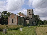
Kelling is a village and a civil parish
in the English
county of Norfolk
. The village is 10.1 miles (16.3 km) west of Cromer
, 26 miles (41.8 km) north of Norwich
and 130 miles (209.2 km) north-east of London
. The village straddles the A149 Coast road
between Kings Lynn and Great Yarmouth
. The nearest railway station is at Sheringham
for the Bittern Line
which runs between Sheringham
, Cromer and Norwich. The nearest airport is Norwich International Airport
. The village lies within the Norfolk Coast AONB
(Area of Outstanding Natural Beauty
) and the North Norfolk Heritage Coast.
Changes in government policy have discontinued management of coastal erosion
in North Norfolk.
school house built in 1876 and opened October 1877, still in use as a primary school today on the coastal side of the A149 just opposite the reading room. Today it is attended by 90 children from the surrounding area. The postal addresses for Kelling are unusual as only 10 of the 37 properties have a number; the rest are known only by the house name the postcode for the village is NR25 7EL.
Around Kelling are Kelling Heath
and Muckleburgh Hill, two raised areas of outstanding natural beauty. The heaths contain a network of paths, nature trail and views of the surrounding area. Kelling village is 1 km from the coast which is accessed via a road used as a public path (RUPP). The coastline at Kelling along with Weybourne and Salthouse
was of part the strategic defence
during the Second World War.
Civil parish
In England, a civil parish is a territorial designation and, where they are found, the lowest tier of local government below districts and counties...
in the English
England
England is a country that is part of the United Kingdom. It shares land borders with Scotland to the north and Wales to the west; the Irish Sea is to the north west, the Celtic Sea to the south west, with the North Sea to the east and the English Channel to the south separating it from continental...
county of Norfolk
Norfolk
Norfolk is a low-lying county in the East of England. It has borders with Lincolnshire to the west, Cambridgeshire to the west and southwest and Suffolk to the south. Its northern and eastern boundaries are the North Sea coast and to the north-west the county is bordered by The Wash. The county...
. The village is 10.1 miles (16.3 km) west of Cromer
Cromer
Cromer is a coastal town and civil parish in north Norfolk, England. The local government authority is North Norfolk District Council, whose headquarters is in Holt Road in the town. The town is situated 23 miles north of the county town, Norwich, and is 4 miles east of Sheringham...
, 26 miles (41.8 km) north of Norwich
Norwich
Norwich is a city in England. It is the regional administrative centre and county town of Norfolk. During the 11th century, Norwich was the largest city in England after London, and one of the most important places in the kingdom...
and 130 miles (209.2 km) north-east of London
London
London is the capital city of :England and the :United Kingdom, the largest metropolitan area in the United Kingdom, and the largest urban zone in the European Union by most measures. Located on the River Thames, London has been a major settlement for two millennia, its history going back to its...
. The village straddles the A149 Coast road
A149 road
The A149 is a major route in Norfolk, linking Kings Lynn to Great Yarmouth. It runs via the coast rather than on a more direct route such as the A47. The eastern section runs through The Broads.-Kings Lynn to Wells next the Sea:...
between Kings Lynn and Great Yarmouth
Great Yarmouth
Great Yarmouth, often known to locals as Yarmouth, is a coastal town in Norfolk, England. It is at the mouth of the River Yare, east of Norwich.It has been a seaside resort since 1760, and is the gateway from the Norfolk Broads to the sea...
. The nearest railway station is at Sheringham
Sheringham railway station
Sheringham railway station is a timber halt in the town of Sheringham in the English county of Norfolk. The station is the terminus of the Bittern Line, operated by National Express East Anglia, and is 49 km north of...
for the Bittern Line
Bittern Line
The Bittern Line is a railway line from Norwich to Cromer then Sheringham in Norfolk, England. It is one of the most scenic in the East of England traversing the Norfolk Broads on its route to the Area of Outstanding Natural Beauty on the North Norfolk Coast. The line is part of the Network Rail...
which runs between Sheringham
Sheringham
Sheringham is a seaside town in Norfolk, England, west of Cromer.The motto of the town, granted in 1953 to the Sheringham Urban District Council, is Mare Ditat Pinusque Decorat, Latin for "The sea enriches and the pine adorns"....
, Cromer and Norwich. The nearest airport is Norwich International Airport
Norwich International Airport
Norwich International Airport , also known as Norwich Airport, is an airport in the City of Norwich within Norfolk, England north of the city centre and on the edge of the city's suburbs....
. The village lies within the Norfolk Coast AONB
Norfolk Coast AONB
The Norfolk Coast Area of Outstanding Natural Beauty covers over 450 km2 of coastal and agricultural land from the The Wash in the west through coastal marshes and cliffs to the sand dunes at Winterton in the east....
(Area of Outstanding Natural Beauty
Area of Outstanding Natural Beauty
An Area of Outstanding Natural Beauty is an area of countryside considered to have significant landscape value in England, Wales or Northern Ireland, that has been specially designated by the Countryside Agency on behalf of the United Kingdom government; the Countryside Council for Wales on...
) and the North Norfolk Heritage Coast.
Changes in government policy have discontinued management of coastal erosion
Coastal erosion
Coastal erosion is the wearing away of land and the removal of beach or dune sediments by wave action, tidal currents, wave currents, or drainage...
in North Norfolk.
Village amenities
Kelling is a small village (pop 170 in 2004), which had a reputation for smuggling. The village has a reading room, which is now a book shop, gallery and tea-room. There is a small VictorianVictorian era
The Victorian era of British history was the period of Queen Victoria's reign from 20 June 1837 until her death on 22 January 1901. It was a long period of peace, prosperity, refined sensibilities and national self-confidence...
school house built in 1876 and opened October 1877, still in use as a primary school today on the coastal side of the A149 just opposite the reading room. Today it is attended by 90 children from the surrounding area. The postal addresses for Kelling are unusual as only 10 of the 37 properties have a number; the rest are known only by the house name the postcode for the village is NR25 7EL.
Around Kelling are Kelling Heath
Kelling Heath
Kelling Heath is an area of heathland on the coast of North Norfolk, England, between Holt and Weybourne. It has been designated a Site of Special Scientific Interest, and is described by Natural England as 'a fine example of oceanic heathland'...
and Muckleburgh Hill, two raised areas of outstanding natural beauty. The heaths contain a network of paths, nature trail and views of the surrounding area. Kelling village is 1 km from the coast which is accessed via a road used as a public path (RUPP). The coastline at Kelling along with Weybourne and Salthouse
Salthouse
Salthouse is a village and a civil parish in the English county of Norfolk. It is situated on the salt marshes of North Norfolk. It is north of Holt, west of Sheringham and north of Norwich. The village is on the A149 coast road between King's Lynn and Great Yarmouth. The nearest railway station...
was of part the strategic defence
British hardened field defences of World War II
British hardened field defences of World War II were small fortified structures constructed as a part of British anti-invasion preparations. They were popularly known as pillboxes by reference to their shape.-Design and development:...
during the Second World War.
Neighbouring villages
- Weybourne
- SalthouseSalthouseSalthouse is a village and a civil parish in the English county of Norfolk. It is situated on the salt marshes of North Norfolk. It is north of Holt, west of Sheringham and north of Norwich. The village is on the A149 coast road between King's Lynn and Great Yarmouth. The nearest railway station...
- High KellingHigh KellingHigh Kelling is a village and civil parish in the north of the English county of Norfolk. The village is located on the A148 road which links Cromer to King's Lynn. The village is 1.7 miles east of the town of Holt, and 7.8 miles west of Cromer. High Kelling is within the area covered by North...
- Cley next the SeaCley next the SeaCley next the Sea is a village on the River Glaven in Norfolk, England, 4 miles north-west of Holt and east of Blakeney. The main A149 coast road runs through the centre of the village, causing congestion in the summer months due to the tight, narrow streets. It lies within the Norfolk Coast AONB...
- WivetonWivetonWiveton is a village and civil parish in the English county of Norfolk. It is situated on the west bank of the River Glaven, inland from the coast and directly across the river from the village of Cley next the Sea...