

Kawartha lakes
Encyclopedia
The Kawartha lakes are a band of lakes in south-central Ontario
, Canada
that form the upper watershed
of the Trent River
. The lakes all lie upon the boundary between the Paleozoic limestone
regions of the Golden Horseshoe
, and the Precambrian granite
Canadian Shield
of northern and central Ontario.
"Kawartha" is an anglicization of the word "Ka-wa-tha" (from "Ka-wa-tae-gum-maug" or Gaa-waategamaag), a word coined in 1895 by aboriginal Martha Whetung of the Curve Lake
First Nations. It was hoped that the word, which meant "land of reflections" in the Anishinaabe language, would provide a convenient and popular advertising label for the area, much as "Muskoka" had come to describe the area and lakes north of Gravenhurst
. The word was subsequently changed by tourism promoters to Kawartha, with the meaning "bright waters and happy lands."
Though the city of Kawartha Lakes
is named for them, more than half of the Kawartha Lakes are in fact located in Peterborough County
. The Trent-Severn Waterway
makes its way through many lakes in the main chain; many cottages dot the lakes' shorelines some of which are quite large in size, and the region is most known for its recreational tourism
.
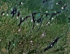 Lakes considered to be among 'The Kawarthas' include:
Some additional lakes are sometimes included, but are not part of the Kawarthas:
, Beaver Lake, Mississauga Lake
, Gold Lake, McGinnis Lake, Cold Lake, and Cavendish Lake.
Also nearby, but not reachable by boat without portage, are Gull Lake
, Anstruther Lake
, Bottle Lake, and Sucker Lake. The area is partially enclosed by Kawartha Highlands Provincial Park
.
Ontario
Ontario is a province of Canada, located in east-central Canada. It is Canada's most populous province and second largest in total area. It is home to the nation's most populous city, Toronto, and the nation's capital, Ottawa....
, Canada
Canada
Canada is a North American country consisting of ten provinces and three territories. Located in the northern part of the continent, it extends from the Atlantic Ocean in the east to the Pacific Ocean in the west, and northward into the Arctic Ocean...
that form the upper watershed
Drainage basin
A drainage basin is an extent or an area of land where surface water from rain and melting snow or ice converges to a single point, usually the exit of the basin, where the waters join another waterbody, such as a river, lake, reservoir, estuary, wetland, sea, or ocean...
of the Trent River
Trent River (Ontario)
The Trent River is a river in southeastern Ontario which flows from Rice Lake to empty into the Bay of Quinte on Lake Ontario. This river is part of the Trent-Severn Waterway which leads to Georgian Bay. The river is 90 km long...
. The lakes all lie upon the boundary between the Paleozoic limestone
Limestone
Limestone is a sedimentary rock composed largely of the minerals calcite and aragonite, which are different crystal forms of calcium carbonate . Many limestones are composed from skeletal fragments of marine organisms such as coral or foraminifera....
regions of the Golden Horseshoe
Golden Horseshoe
The Golden Horseshoe is a densely populated and industrialized region centred around the Greater Toronto Area at the western end of Lake Ontario in Southern Ontario, Canada, with outer boundaries stretching south to Lake Erie and north to Georgian Bay. Most of it is also part of the Quebec City...
, and the Precambrian granite
Granite
Granite is a common and widely occurring type of intrusive, felsic, igneous rock. Granite usually has a medium- to coarse-grained texture. Occasionally some individual crystals are larger than the groundmass, in which case the texture is known as porphyritic. A granitic rock with a porphyritic...
Canadian Shield
Canadian Shield
The Canadian Shield, also called the Laurentian Plateau, or Bouclier Canadien , is a vast geological shield covered by a thin layer of soil that forms the nucleus of the North American or Laurentia craton. It is an area mostly composed of igneous rock which relates to its long volcanic history...
of northern and central Ontario.
"Kawartha" is an anglicization of the word "Ka-wa-tha" (from "Ka-wa-tae-gum-maug" or Gaa-waategamaag), a word coined in 1895 by aboriginal Martha Whetung of the Curve Lake
Curve Lake First Nation 35, Ontario
Curve Lake is the name of two Ojibwe Indian reserves 14 km north of Peterborough, Ontario. They serve as the landbase for the Curve Lake First Nation...
First Nations. It was hoped that the word, which meant "land of reflections" in the Anishinaabe language, would provide a convenient and popular advertising label for the area, much as "Muskoka" had come to describe the area and lakes north of Gravenhurst
Gravenhurst, Ontario
Gravenhurst is a town in the Muskoka Region of Ontario, Canada. It is located approximately south of Bracebridge, Ontario. The mayor is Paisley Donaldson...
. The word was subsequently changed by tourism promoters to Kawartha, with the meaning "bright waters and happy lands."
Though the city of Kawartha Lakes
Kawartha Lakes, Ontario
The city of Kawartha Lakes is a unitary municipality in Central Ontario, Canada. Although called a city, Kawartha Lakes is the size of a typical Ontarian county and is mostly rural....
is named for them, more than half of the Kawartha Lakes are in fact located in Peterborough County
Peterborough County, Ontario
Peterborough County is located in Southern Ontario, Canada. It is projected to reach a population of 159,840 by 2031, according to the Ontario Ministry of Finance's Ontario Population Projections Update...
. The Trent-Severn Waterway
Trent-Severn Waterway
The Trent–Severn Waterway is a Canadian canal system formerly used for industrial and transportation purposes and now for recreational and tourism purposes, connecting Lake Ontario at Trenton to the Georgian Bay portion of Lake Huron at Port Severn...
makes its way through many lakes in the main chain; many cottages dot the lakes' shorelines some of which are quite large in size, and the region is most known for its recreational tourism
Tourism
Tourism is travel for recreational, leisure or business purposes. The World Tourism Organization defines tourists as people "traveling to and staying in places outside their usual environment for not more than one consecutive year for leisure, business and other purposes".Tourism has become a...
.
Primary chain
- Balsam LakeBalsam Lake (Ontario)Balsam Lake is a lake located in the Kawartha lakes region of south central Ontario, Canada. It is 16 km long and averages 3 km wide, though its actual width varies due to the many large bays the carve its shoreline...
(C) - Cameron LakeCameron Lake (Ontario)Cameron Lake, Ontario is one of the Kawartha Lakes and is a lake bordering the town of Fenelon Falls and is part of the Trent-Severn Waterway. The lake is some 6.7 kilometres long by 3.5 kilometres wide and is quite deep, reaching 15 metres in places...
(E) - Sturgeon LakeSturgeon Lake (Ontario)Sturgeon Lake is a lake in the Kawartha Lakes region of Ontario, Canada. It is part of the Trent-Severn Waterway. The lake is Y shaped and has the communities of Fenelon Falls, Lindsay, Sturgeon Point and Bobcaygeon at the north-west, south, central and north-east points of the Y respectively...
(F) - Pigeon LakePigeon Lake (Ontario)-References:*...
(G) - Buckhorn LakeBuckhorn Lake (Ontario)Buckhorn Lake is a lake in the townships of Galway-Cavendish and Harvey and Smith–Ennismore–Lakefield in Peterborough County, Ontario, Canada, and is one of the Kawartha lakes.The primary inflow is from Pigeon Lake through the Gannon Narrows at the west...
(H) - Lake ChemongLake ChemongLake Chemong, or Chemong Lake, " is a lake 8 km NW of Peterborough, Ontario near the town of Bridgenorth. The lake extends from near Fowlers Corners north to near Curve Lake. Lake Chemong has a length of 14 km and a width of 1 km....
(J) - Lower Buckhorn LakeLower Buckhorn Lake-References:*...
(K) - Lovesick Lake (Between K & L)
- Stony LakeStony Lake (Ontario)Stoney Lake is a lake in Ontario, Canada. There are three interconnected lakes . Stoney Lake forms the eastern end of the Kawartha lakes region...
(L) - Lake ScugogLake ScugogLake Scugog is an artificially flooded lake in Scugog Township between the town of Port Perry, Ontario and the town of Lindsay. The lake has been raised and lowered several times over its history. Though not technically part of the Kawarthas due to its shallow depths, it is often geographically...
(S) is to the southwest of the main chain.
Some additional lakes are sometimes included, but are not part of the Kawarthas:
- Clear Lake (M)
- White/Dummer Lake
- Katchewanooka LakeKatchewanooka LakeKatchewanooka Lake is one of the Kawartha lakes in south-central Ontario, Canada. It is about 5 miles long and a half mile wide. The Trent Severn Waterway flows through Lake Katchewanooka into the Otonabee River at its outlet just north of Lakefield, continuing southwest through Peterborough into...
(N) - Rice LakeRice Lake (Ontario)Rice Lake is a lake located in south-eastern Ontario, in Northumberland County, south of Peterborough and the Kawartha lakes and north of Cobourg. The lake is part of the Trent-Severn Waterway, which flows into the lake by the Otonabee and out via the Trent. The lake is 32 km long and...
(R) - Salerno LakeSalerno LakeSalerno Lake, formerly Devil's Lake, is a lake in Ontario's cottage country. It is an approximately 2 and a half hour drive away from Toronto. Salerno Lake is about long. It is a narrow lake that resembles a large river. The lake is in a big valley, and the water level drops off rather quickly...
- Jack LakeJack Lake (Peterborough County, Ontario)Jack Lake is a small headwater/ feedwater lake in Ontario, Canada, within the northern portion of the Kawartha lakes region which is located at the southern end of the Canadian Shield. The clean freshwater lake which has a reasonably complex limnology is located in northern Peterborough County,...
(P)
Kawartha Highlands
A system of interconnected lakes lies to the north of the main chain. Due to an artificial dam placed at the south end of Mississauga lake in the mid-20th century, these lakes have equal levels and are inter-navigable. They consist of Catchacoma LakeCatchacoma Lake
Catchacoma Lake is a lake located in the Kawartha Highlands of Ontario, Canada.-References:*...
, Beaver Lake, Mississauga Lake
Mississauga Lake
Mississagua Lake is a lake of Ontario, Canada. It borders the western section of the Kawartha Highlands Signature Site Park. Containing several privately owned cottages, over the last 5-10 years it has become a popular destination for several successful business owners/executives, as well as...
, Gold Lake, McGinnis Lake, Cold Lake, and Cavendish Lake.
Also nearby, but not reachable by boat without portage, are Gull Lake
Gull Lake (Ontario)
Gull Lake is a lake of Ontario, Canada.Gull Lake is found in northern Ontario. It is the source for drinking water for the community of Kirkland Lake, and it is most popular for bass fishing....
, Anstruther Lake
Anstruther Lake
Anstruther Lake is a lake in the township of North Kawartha, Peterborough County, Ontario, Canada, between the community of Apsley on Ontario Highway 28 to the east and the community of Catchacoma on Ontario Highway 507 to the west. Kawartha Highlands Provincial Park encompasses the lake, and the...
, Bottle Lake, and Sucker Lake. The area is partially enclosed by Kawartha Highlands Provincial Park
Kawartha Highlands Provincial Park
Kawartha Highlands Provincial Park is a 375 km² area of preserved wilderness and recreational areas in south-central Ontario, Canada. It is located to the north and east of the main belt of the Kawartha lakes primarily in the township of North Kawartha...
.