

Kaptai Dam
Encyclopedia
Karnaphuli River
Karnaphuli is a wide river in the south-eastern part of Bangladesh. Originating from the Lushai hills in Mizoram, India, it flows southwest through Chittagong Hill Tracts and Chittagong into the Bay of Bengal. A large hydroelectric power plant using Karnaphuli river was built in the Kaptai...
at Kaptai
Kaptai
Kaptai is a region in south-eastern Bangladesh. The Kaptai Upazila is part of the Rangamati District of Chittagong Division. Karnaphuli Hydroelectric Power Station, the only Hydro-electric power plant of Bangladesh is located here...
, 65 km upstream from Chittagong
Chittagong
Chittagong ) is a city in southeastern Bangladesh and the capital of an eponymous district and division. Built on the banks of the Karnaphuli River, the city is home to Bangladesh's busiest seaport and has a population of over 4.5 million, making it the second largest city in the country.A trading...
in Rangamati District
Rangamati District
Rangamati is a district in South-eastern Bangladesh. It is a part of the Chittagong Hill Tracts and the town of Rangamati serves as the headquarters of the district. Area-wise, Rangamati is the largest district of the country....
, Bangladesh
Bangladesh
Bangladesh , officially the People's Republic of Bangladesh is a sovereign state located in South Asia. It is bordered by India on all sides except for a small border with Burma to the far southeast and by the Bay of Bengal to the south...
. It is an earthfill embankment dam
Embankment dam
An embankment dam is a massive artificial water barrier. It is typically created by the emplacement and compaction of a complex semi-plastic mound of various compositions of soil, sand, clay and/or rock. It has a semi-permanent waterproof natural covering for its surface, and a dense, waterproof...
with a reservoir (known as Kaptai Lake
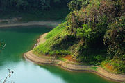
Kaptai Lake
Kaptai Lake is a man made lake in south-eastern Bangladesh. It is located in the Kaptai Upazila under Rangamati District of Chittagong Division. The lake was created as a result of building the Kaptai Dam on the Karnaphuli River, as part of the Karnaphuli Hydro-electric project...
) water storage capacity of 11,000 km². The primary purpose of the construction of the dam and reservoir was to generate hydroelectric power. Construction was completed in 1962.
History
A brief reconnaissance was carried out in 1906 when the Karnafuli Hydropower Station was first contemplated. A second study was carried out in 1923. In 1946, E. A. Moore recommended the proposed project at Barkal about 65 kilometers upstream of present dam site at Kaptai. In 1950, Marz Rendal Vatten Consulting Engineers proposed a site at Chilardak, about 45 kilometers upstream of Kaptai. In 1951, the government engineers proposed a site at Chitmoram which is 11 kilometers downstream of the present site. Under the guidance of then Chief Engineer (Irrigation) Khwaja Azimuddin, the construction site was chosen at present location of the dam in 1951. The International Engineering Co. Inc. (IECO) was engaged for a study on the project. Utah International Inc. was selected as construction contractor. The construction of the dam started in 1957.Construction
Starting in 1957, the initial phase of the construction was completed in 1962. By this time the dam, spillway, penstock and two units of powerhouses were built. Each of the powerhouses was capable of generating 40MW of electricity. In November 1981 another 50MW generating unit was completed. In October 1988 the 4th and 5th generating units were installed which raised the total generation capacity to 230MW. The total cost of Unit 1, Unit 2 and a part of Unit 3 was Rs. 503 million and the total cost of extension was Tk. 1,900 million. The project was financed by the government, ICA and DLF loan.Description
The earthen dam is 670 meters long and 45.7 meters wide with a 16-gated spillway on the left side of the main dam. The catchment area of the reservoir is 11,000 km². The dam has provided significant flood control as well as power generation.The construction of the dam submerged 655 km² area. This included 220 km² of cultivable land, 40 percent of the cultivable land in the area, and displaced 18,000 families and 100,000 tribal people, of which 70% were Chakma
Chakma
Chakma may refer to:*Chakma people, a Tibeto-Burman people of Bangladesh and Northeast India*Chakma language, the Indo-European language spoken by them*Chakma script...
. The dam also flooded the original Rangamati
Rangamati
Rangamati is the Administrative Headquarter of Rangamati Hill District in the Chittagong Hill Tracts of Bangladesh. The town is located at 22°37'60N 92°12'0E and has an altitude of 14 metres ....
town and other structures.
Kaptai Dam and the Spillways At a Glance:
The Dam
| Feature | Description |
|---|---|
| Body of the Dam | Earthen |
| Length | 670.6m |
| Height | 45.7m |
| Width | 7.6m (At Crest), 45.7m (At Bottom) |
| Maximum Water Level | 33.5m (110ft above MSL) |
| Minimum Water Level | 20.1m |
| Reservoir Capacity at 33m | 6,477x106m3 |
| Reservoir Area | 777km2 at 33m |
| Average Annual Flow | 15,646,000,000 cubic metres3 |
| Installed Capacity | 230 MW |
The Spillways
| Feature | Description |
|---|---|
| No. of Gates | 16 |
| Total Length | 227 m |
| Size of the Gates | 12.2 m x 11.3 m |
| Crest Level | 21.9 m |
| Bridge Level | 39.9 m |
| Maximum Discharge | 16,000 m³/s |
| Gate Hoist | 75 Tons |
| Tailrace Length | 1219 m |
| Tailrace Width | 122 m |
Disadvantages
Local inhabitants living in the storage reservoir area who lost their homes and farmland due to flooding were not compensated. More than 40,000 Chakma tribals emigrated to IndiaIndia
India , officially the Republic of India , is a country in South Asia. It is the seventh-largest country by geographical area, the second-most populous country with over 1.2 billion people, and the most populous democracy in the world...
. The scarcity of land is considered a main cause of the continuing conflict in the area today.
The building of the dam and reservoir also caused destruction of wilderness and loss of wildlife and wildlife habitats.