

Kamilaroi Highway
Encyclopedia
Highway
A highway is any public road. In American English, the term is common and almost always designates major roads. In British English, the term designates any road open to the public. Any interconnected set of highways can be variously referred to as a "highway system", a "highway network", or a...
in New South Wales
New South Wales
New South Wales is a state of :Australia, located in the east of the country. It is bordered by Queensland, Victoria and South Australia to the north, south and west respectively. To the east, the state is bordered by the Tasman Sea, which forms part of the Pacific Ocean. New South Wales...
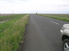
. It has been given the national route number 37. Its status as a highway is fairly new.
It runs 620 km from Willow Tree
Willow Tree, New South Wales
Willow Tree is a village composed of about 169 people, located in New South Wales, Australia. It is situated in the Liverpool Plains, 14 kilometers south of Quirindi near the junction of the Kamilaroi and New England Highways. The town itself is small but the farms extend southwest out to the...
on the New England Highway
New England Highway
The New England Highway is a highway in Australia running from Hexham near Newcastle at its southern end to Yarraman near Toowoomba at its northern end. At its southern end it connects to the Pacific Highway and at its northern end it connects to the D'Aguilar Highway. It traverses the Hunter...
in central New South Wales in a north-western direction until it reaches Bourke
Bourke, New South Wales
-Transportation:Bourke can be reached by the Mitchell Highway, with additional sealed roads from town to the north , east and south . The town is also served by Bourke Airport and has Countrylink bus service to other regional centres, like Dubbo...
on the Mitchell Highway
Mitchell Highway
The Mitchell Highway is a major rural highway in Australia, travelling through central and northern New South Wales and south central Queensland. The highway starts from its northern end in Queensland with the Landsborough Highway near Augathella and continues south to Charleville and Cunnamulla...
. The Kamilaroi Highway offers the most direct route from the Great Divide to the Outback
Outback
The Outback is the vast, remote, arid area of Australia, term colloquially can refer to any lands outside the main urban areas. The term "the outback" is generally used to refer to locations that are comparatively more remote than those areas named "the bush".-Overview:The outback is home to a...
.
The highway is named after the Kamilaroi
Kamilaroi
The Kamilaroi or Gamilaraay are an Indigenous Australian people who are from the area between Tamworth and Goondiwindi, and west to Narrabri, Walgett and Lightning Ridge, in northern New South Wales...
Indigenous Australian people who live in the area.
Five kilometres north of Boggabri is the spectacular landmark, Gin’s Leap, which was known in Cobb and Co
Cobb and Co
Cobb and Co is the name of a transportation company in Australia. It was prominent in the late 19th century when it operated stagecoaches to many areas in the outback and at one point in several other countries, as well....
coach days as “The Rock”.
It is said that a young Aboriginal girl, promised to an elder of her tribe, the Kamilaroi, ran away with a young aboriginal man from another tribe. While being pursued by Kamilaroi tribesmen, the lovers jumped to their death from somewhere along the top of this rock.
List of towns and villages on the Kamilaroi Highway
- Willow TreeWillow Tree, New South WalesWillow Tree is a village composed of about 169 people, located in New South Wales, Australia. It is situated in the Liverpool Plains, 14 kilometers south of Quirindi near the junction of the Kamilaroi and New England Highways. The town itself is small but the farms extend southwest out to the...
- QuirindiQuirindi, New South WalesQuirindi is a small town on the North West Slopes region of New South Wales, Australia, in Liverpool Plains Shire Local Government Area ....
- CurlewisCurlewis, New South WalesCurlewis is a parish and a rural village on the Kamilaroi Highway, 16 kilometres south of Gunnedah, New South Wales in Australia. The village boundaries are in the Gunnedah Shire local government area of the North West Slopes portion of the New England region.-History:Curlewis was founded by...
- Gunnedah
- Boggabri
- Narrabri
- Wee Waa
- Walgett
- BrewarrinaBrewarrina, New South WalesBrewarrina is a small town in North West New South Wales, Australia on the banks of the Barwon River in Brewarrina Shire. It is 98 km east of Bourke and west of Walgett on the Kamilaroi Highway, and 808 km from Sydney. Brewarrina has had its population decrease from 1,197 persons in...
- BourkeBourke, New South Wales-Transportation:Bourke can be reached by the Mitchell Highway, with additional sealed roads from town to the north , east and south . The town is also served by Bourke Airport and has Countrylink bus service to other regional centres, like Dubbo...