
Brewarrina, New South Wales
Encyclopedia
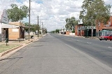
Brewarrina is a small town (2006 population: 1,121
) in North West New South Wales
, Australia
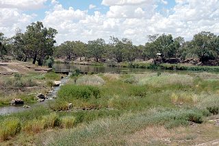
on the banks of the Barwon River
in Brewarrina Shire. It is 98 km east of Bourke
and west of Walgett
on the Kamilaroi Highway
, and 808 km from Sydney
. Brewarrina has had its population decrease from 1,197 persons in 2001, to 1,121 persons in 2006. Other towns and villages in the Brewarrina district include; Goodooga
, Gongolgon, Weilmoringle and Angledool
.
In recent years this precious cultural asset has been neglected and allowed to be obscured by a proliferation of river weed.
 No one knows exactly what the word "Brewarrina" means. There are five competing interpretations of the name, several of them mutually exclusive. The most common translation is "clumps of acacias"; others are "where the gooseberry grows", "fishing", "acacia clumps" and, perhaps the most plausible, "place of gooseberries", coming from "warrina", meaning "place of", and "bre" or "burie" or "biree" meaning "gooseberries".
The first white settlers arrived in the district around 1839-40. The first people to own land where the town now stands were the Lawson brothers, who had two holdings - one called "Walcha" and another called "Moona". The first name given to the settlement was "Walcha Hut" but this later changed to "Fishery" and finally to "Brewarrina". In 1859 a riverboat called Gemini, skippered by William Randell, reached the town. This opened up the possibility of developing the town as a port, and by the early 1860s Brewarrina was recognised as the furthest navigable point on the Darling River
. The town was formally surveyed and laid out in 1861, and proclaimed on 28 April 1863.
The 1870s were something of a boom time for Brewarrina. The Mechanics Institute was formed in 1873. The following year two hotels, two stores and the Commercial Bank all opened, and in 1875 a public school was established. All this development was largely due to Cobb and Co
, which had a number of coach services passing through the town. There was a service from Byrock
, one from Dubbo via Warren
and, in 1874, a direct service from Brewarrina to Enngonia, north of Bourke. The number of people moving through the town at this time would have been considerable and would have given rise to the increase in stores and hotels.
In recent years there have been concerns at the high levels of violence and drug use in the town.
Brewarrina, on the wide Barwon River is an ideal place to fish. With the largest officially recorded cod being caught here, weighing 113 kilograms (250lbs). The river is also used for swimming in the summer months, and is a great spot for water skiing.
Brewarrina is also well known for its annual 'Festival of the Fisheries', which celebrates Brewarrina's Aboriginal and European History. Sadly, the event has sometimes not been held in recent years.
Other annual events include the local agricultural show, and the Brewarrina races.
Especially noteworthy is the Brewarrina 'Surfboat Classic', the only one of its type, in which canoes are raced up the Barwon River. This event usually attracts hundreds of spectators from neighbouring communities and even from the east of the state.
, on the Nyngan
to Bourke
line. This closed in 1974.
) in North West New South Wales
New South Wales
New South Wales is a state of :Australia, located in the east of the country. It is bordered by Queensland, Victoria and South Australia to the north, south and west respectively. To the east, the state is bordered by the Tasman Sea, which forms part of the Pacific Ocean. New South Wales...
, Australia
Australia
Australia , officially the Commonwealth of Australia, is a country in the Southern Hemisphere comprising the mainland of the Australian continent, the island of Tasmania, and numerous smaller islands in the Indian and Pacific Oceans. It is the world's sixth-largest country by total area...
on the banks of the Barwon River
Barwon River (New South Wales)
The Barwon River flows through New South Wales, virtually as a continuation of the Macintyre River / Border Rivers system, before joining with the Culgoa River to form the Darling River...
in Brewarrina Shire. It is 98 km east of Bourke
Bourke, New South Wales
-Transportation:Bourke can be reached by the Mitchell Highway, with additional sealed roads from town to the north , east and south . The town is also served by Bourke Airport and has Countrylink bus service to other regional centres, like Dubbo...
and west of Walgett
Walgett, New South Wales
Walgett is a town in North-West New South Wales, Australia and the seat of Walgett Shire. It is at the junction of the Barwon and Namoi rivers and near the junction of the Kamilaroi and Castlereagh Highways...
on the Kamilaroi Highway
Kamilaroi Highway
Kamilaroi Highway is a state highway in New South Wales. It has been given the national route number 37. Its status as a highway is fairly new....
, and 808 km from Sydney
Sydney
Sydney is the most populous city in Australia and the state capital of New South Wales. Sydney is located on Australia's south-east coast of the Tasman Sea. As of June 2010, the greater metropolitan area had an approximate population of 4.6 million people...
. Brewarrina has had its population decrease from 1,197 persons in 2001, to 1,121 persons in 2006. Other towns and villages in the Brewarrina district include; Goodooga
Goodooga, New South Wales
Goodooga is a village in the Australian state of New South Wales in Brewarrina Shire on the eastern bank of the Bokhara River. It is near Brewarrina and Lightning Ridge, its closest neighbour. The town lies 20 kilometres south of the Queensland border. Goodooga is an Aboriginal word meaning,...
, Gongolgon, Weilmoringle and Angledool
Angledool, New South Wales
Angledool is a locality in upper western New South Wales near the southern border of Queensland, one kilometre east of the Castlereagh Highway and approximately 45 kilometres north of Lightning Ridge...
.
Fish traps
Brewarrina's most significant feature is its Aboriginal fish traps. Known in the local Aboriginal language as Ngunnhu, the traps are believed to be at least 40,000 years old, possibly the oldest surviving human-made structure in the world. Consisting of river stones arranged to form small channels, the traps directed fish into small areas from which they could be readily plucked. The traps were included in the National Heritage List on 3 June 2005 -the only such site in NSW outside of Sydney- with a current application for World Heritage Listing. The ready availability of fish made Brewarrina one of the great inter-tribal meeting places of pre-European eastern Australia.In recent years this precious cultural asset has been neglected and allowed to be obscured by a proliferation of river weed.
History
The town is located amid the traditional lands of the Ngemba, Muwarrari and Yualwarri peoples. The area has a long Indigenous Australian history and was once the meetings grounds for over 5,000 people.The first white settlers arrived in the district around 1839-40. The first people to own land where the town now stands were the Lawson brothers, who had two holdings - one called "Walcha" and another called "Moona". The first name given to the settlement was "Walcha Hut" but this later changed to "Fishery" and finally to "Brewarrina". In 1859 a riverboat called Gemini, skippered by William Randell, reached the town. This opened up the possibility of developing the town as a port, and by the early 1860s Brewarrina was recognised as the furthest navigable point on the Darling River
Darling River
The Darling River is the third longest river in Australia, measuring from its source in northern New South Wales to its confluence with the Murray River at Wentworth, New South Wales. Including its longest contiguous tributaries it is long, making it the longest river system in Australia.The...
. The town was formally surveyed and laid out in 1861, and proclaimed on 28 April 1863.
The 1870s were something of a boom time for Brewarrina. The Mechanics Institute was formed in 1873. The following year two hotels, two stores and the Commercial Bank all opened, and in 1875 a public school was established. All this development was largely due to Cobb and Co
Cobb and Co
Cobb and Co is the name of a transportation company in Australia. It was prominent in the late 19th century when it operated stagecoaches to many areas in the outback and at one point in several other countries, as well....
, which had a number of coach services passing through the town. There was a service from Byrock
Byrock, New South Wales
Byrock is a small village in north western New South Wales, Australia in Bourke Shire. In 2006, Byrock had a population of 90 people.It is named after a rock hole, called Bai by the Nyammba tribe...
, one from Dubbo via Warren
Warren, New South Wales
Warren is a town and the seat of a local government area, Warren Shire, on the Macquarie River in central New South Wales, Australia. The town is located on the Oxley Highway 120 kilometres north west of Dubbo. It was laid out in the 1860s and incorporated as a municipality in 1895. The railway...
and, in 1874, a direct service from Brewarrina to Enngonia, north of Bourke. The number of people moving through the town at this time would have been considerable and would have given rise to the increase in stores and hotels.
In recent years there have been concerns at the high levels of violence and drug use in the town.
Sport and recreation
The townspeople of Brewarrina play a variety of sports. The town has a local Rugby Union club and team, the Brewarrina Brumbies. Rugby League is a very popular sport in Brewarrina, with the town sporting a number of different teams. Netball is played weekly, with over 12 teams playing in the local competition. The Brewarrina Golf Club is renowned throughout the western region as one of the best 'oiled' green golf courses. Other major sports in Brewarrina include bowls, shooting, tennis and swimming. Brewarrina also has a very successful circus skills program, which trains local kids skills in circus training and gives them the opportunity to travel across the country to places like Adelaide and Melbourne. This program has also given particular kids the chance to travel overseas, with one girl travelling to South Africa to perform in the art of circus skills.Brewarrina, on the wide Barwon River is an ideal place to fish. With the largest officially recorded cod being caught here, weighing 113 kilograms (250lbs). The river is also used for swimming in the summer months, and is a great spot for water skiing.
Events
Brewarrina is host to one of the most famous Rodeos in the far west of New South Wales, the 'Barwon River Rodeo', which is usually held on the New South Wales Easter long weekend.Brewarrina is also well known for its annual 'Festival of the Fisheries', which celebrates Brewarrina's Aboriginal and European History. Sadly, the event has sometimes not been held in recent years.
Other annual events include the local agricultural show, and the Brewarrina races.
Especially noteworthy is the Brewarrina 'Surfboat Classic', the only one of its type, in which canoes are raced up the Barwon River. This event usually attracts hundreds of spectators from neighbouring communities and even from the east of the state.
Notable citizens
- Leo SchofieldLeo SchofieldLeo Schofield AM is an Australian restaurant critic, advertising professional and arts festival director....
, restaurant critic, advertising professional and arts festival director. - Isaac GordonIsaac GordonIsaac Gordon , is an Indigenous Australian rugby league player for the Cronulla Sharks in the NRL competition...
, plays in the NRL with the Cronulla Sharks. - Ashley GordonAshley GordonAshley Gordon was an Indigenous Australian rugby league footballer for the Newcastle Knights and Penrith Panthers of the National Rugby League...
, played Rugby League for the Newcastle Knights and Penrith Panthers.
Railway
In 1901 a railway branch line was opened to Brewarrina from ByrockByrock, New South Wales
Byrock is a small village in north western New South Wales, Australia in Bourke Shire. In 2006, Byrock had a population of 90 people.It is named after a rock hole, called Bai by the Nyammba tribe...
, on the Nyngan
Nyngan, New South Wales
Nyngan [pr: ning-g'n] is a town in the central west of New South Wales, Australia. It is located in the Bogan Shire Local Government Area. At the 2006 census, Nyngan had a population of 1,975 people. Nyngan is situated on the Bogan River between Narromine and Bourke, on the junction of the...
to Bourke
Bourke, New South Wales
-Transportation:Bourke can be reached by the Mitchell Highway, with additional sealed roads from town to the north , east and south . The town is also served by Bourke Airport and has Countrylink bus service to other regional centres, like Dubbo...
line. This closed in 1974.