

Isles Phelipeaux and Pontchartrain
Encyclopedia
Phantom island
Phantom islands are islands that were believed to exist, and appeared on maps for a period of time during recorded history, but were later removed after they were proved to be nonexistent...
s in
Lake Superior
Lake Superior
Lake Superior is the largest of the five traditionally-demarcated Great Lakes of North America. It is bounded to the north by the Canadian province of Ontario and the U.S. state of Minnesota, and to the south by the U.S. states of Wisconsin and Michigan. It is the largest freshwater lake in the...
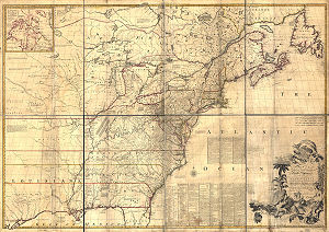
, believed at one time to be real, shown on early maps, such as the Mitchell Map
Mitchell Map
The Mitchell Map is a map made by John Mitchell , which was reprinted several times during the second half of the 18th century. The Mitchell Map was used as a primary map source during the Treaty of Paris for defining the boundaries of the newly independent United States...
, of
Lake Superior
Lake Superior
Lake Superior is the largest of the five traditionally-demarcated Great Lakes of North America. It is bounded to the north by the Canadian province of Ontario and the U.S. state of Minnesota, and to the south by the U.S. states of Wisconsin and Michigan. It is the largest freshwater lake in the...
as located between the Keweenaw Peninsula
Keweenaw Peninsula
The Keweenaw Peninsula is the northern-most part of Michigan's Upper Peninsula. It projects into Lake Superior and was the site of the first copper boom in the United States. As of the 2000 census, its population was roughly 43,200...
and Isle Royale
Isle Royale
Isle Royale is an island of the Great Lakes, located in the northwest of Lake Superior, and part of the state of Michigan. The island and the 450 surrounding smaller islands and waters make up Isle Royale National Park....
.
Although non-existent, Isle Phelipeaux was referenced in the 1783 Treaty of Paris
Treaty of Paris (1783)
The Treaty of Paris, signed on September 3, 1783, ended the American Revolutionary War between Great Britain on the one hand and the United States of America and its allies on the other. The other combatant nations, France, Spain and the Dutch Republic had separate agreements; for details of...
that ended the American Revolutionary War
American Revolutionary War
The American Revolutionary War , the American War of Independence, or simply the Revolutionary War, began as a war between the Kingdom of Great Britain and thirteen British colonies in North America, and ended in a global war between several European great powers.The war was the result of the...
. A portion of the boundary between the United States
United States
The United States of America is a federal constitutional republic comprising fifty states and a federal district...
and British
Great Britain
Great Britain or Britain is an island situated to the northwest of Continental Europe. It is the ninth largest island in the world, and the largest European island, as well as the largest of the British Isles...
colonies in Canada
Canada
Canada is a North American country consisting of ten provinces and three territories. Located in the northern part of the continent, it extends from the Atlantic Ocean in the east to the Pacific Ocean in the west, and northward into the Arctic Ocean...
was described as running "through Lake Superior northward of the Isles Royal and Phelipeaux to the Long Lake." It had first appeared on a map prepared by the cartographer Bellin in 1744. It continued to appear on maps of Lake Superior for many years, including the Mitchell map used in the Paris peace talks, in 1783.
During the 1820s, when surveys were attempting to determine the International Boundary
Canada-United States border
The Canada–United States border, officially known as the International Boundary, is the longest border in the world. The terrestrial boundary is 8,891 kilometers long, including 2,475 kilometres shared with Alaska...
from the Lake of the Woods
Lake of the Woods
Lake of the Woods is a lake occupying parts of the Canadian provinces of Ontario and Manitoba and the U.S. state of Minnesota. It separates a small land area of Minnesota from the rest of the United States. The Northwest Angle and the town of Angle Township can only be reached from the rest of...
to Lake Superior, it was discovered that Isle Phelipeaux did not exist; surveyors were also unable to determine what body of water was meant by the "Long Lake" referenced in the treaty.
A likely reason given for the appearance on maps of these islands was to curry favor with the French
France
The French Republic , The French Republic , The French Republic , (commonly known as France , is a unitary semi-presidential republic in Western Europe with several overseas territories and islands located on other continents and in the Indian, Pacific, and Atlantic oceans. Metropolitan France...
government minister, Louis Phélypeaux
Louis Phélypeaux (1643-1727)
Louis Phélypeaux , marquis de Phélypeaux , comte de Maurepas , comte de Pontchartrain , known as the chancellor de Pontchartrain, was a French politician....
, marquis de La Vrilliere, comte de Pontchartrain, in order to gain funding for additional voyages of exploration.