
Irish Population Analysis
Encyclopedia
The population of Ireland
in 2008 was approximately 6.1 million comprising 4.35 million in the Republic of Ireland
with another 1.75 million in Northern Ireland
. Although this is a significant growth over recent years, it is lower than historical figures.
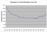
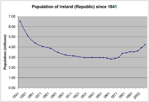
In 1841, the population of the 26 counties
which would later form the Republic of Ireland was over 6.5 million people. The Irish potato famine
and the emigration
it caused had a dramatic effect, so that by 1871 the 26-county population had almost halved to four million, and by 1926 had reduced further to three million. The population held firm around three million until the early 1970s when the population began to rise again. Future predictions are for the population to continue to rise at 1.4% per year until 2021 when the population is predicted to be just over five million. The Republic of Ireland is one of the few remaining developed economies
to have population growth of this scale.
Below are some statistics to illustrate the rise, fall and rise again of the Irish population since 1841. The statistics also illustrate a massive population shift from the West to the East of the country and increasing urbanisation. Counties such as Mayo, Roscommon, Donegal and Leitrim have become depopulated while counties surrounding Dublin including Wicklow, Kildare, Louth and Meath have seen rapid population growth in recent years.
The population of the 6 counties of Ulster
as of 2004 is 1,710,300 which would mean a total population on the island of Ireland as of 2006 of approximately 5,952,761.
See also List of Irish counties by population
Data for Ulster refers to the 3 counties of Ulster that constitute part of the Republic of Ireland
: Cavan, Donegal and Monaghan
Ireland
Ireland is an island to the northwest of continental Europe. It is the third-largest island in Europe and the twentieth-largest island on Earth...
in 2008 was approximately 6.1 million comprising 4.35 million in the Republic of Ireland
Republic of Ireland
Ireland , described as the Republic of Ireland , is a sovereign state in Europe occupying approximately five-sixths of the island of the same name. Its capital is Dublin. Ireland, which had a population of 4.58 million in 2011, is a constitutional republic governed as a parliamentary democracy,...
with another 1.75 million in Northern Ireland
Northern Ireland
Northern Ireland is one of the four countries of the United Kingdom. Situated in the north-east of the island of Ireland, it shares a border with the Republic of Ireland to the south and west...
. Although this is a significant growth over recent years, it is lower than historical figures.
In 1841, the population of the 26 counties
Counties of Ireland
The counties of Ireland are sub-national divisions used for the purposes of geographic demarcation and local government. Closely related to the county is the County corporate which covered towns or cities which were deemed to be important enough to be independent from their counties. A county...
which would later form the Republic of Ireland was over 6.5 million people. The Irish potato famine
Irish Potato Famine (1845–1849)
In Ireland, the Great Famine was a period of mass starvation, disease and emigration between 1845 and 1852. It is also known, mostly outside Ireland, as the Irish Potato Famine...
and the emigration
Emigration
Emigration is the act of leaving one's country or region to settle in another. It is the same as immigration but from the perspective of the country of origin. Human movement before the establishment of political boundaries or within one state is termed migration. There are many reasons why people...
it caused had a dramatic effect, so that by 1871 the 26-county population had almost halved to four million, and by 1926 had reduced further to three million. The population held firm around three million until the early 1970s when the population began to rise again. Future predictions are for the population to continue to rise at 1.4% per year until 2021 when the population is predicted to be just over five million. The Republic of Ireland is one of the few remaining developed economies
Developed country
A developed country is a country that has a high level of development according to some criteria. Which criteria, and which countries are classified as being developed, is a contentious issue...
to have population growth of this scale.
Below are some statistics to illustrate the rise, fall and rise again of the Irish population since 1841. The statistics also illustrate a massive population shift from the West to the East of the country and increasing urbanisation. Counties such as Mayo, Roscommon, Donegal and Leitrim have become depopulated while counties surrounding Dublin including Wicklow, Kildare, Louth and Meath have seen rapid population growth in recent years.
Historical country population
- Data for country population refers to the 26 counties that make up the present state of the Republic of IrelandRepublic of IrelandIreland , described as the Republic of Ireland , is a sovereign state in Europe occupying approximately five-sixths of the island of the same name. Its capital is Dublin. Ireland, which had a population of 4.58 million in 2011, is a constitutional republic governed as a parliamentary democracy,...
| Year | Population | %Change |
|---|---|---|
| 2011 | 4.58m | +7.4 |
| 2006 | 4.24m | +8.1 |
| 2002 | 3.92m | +8.2 |
| 1996 | 3.63m | +2.9 |
| 1991 | 3.53m | -(0.6) |
| 1986 | 3.54m | +2.8 |
| 1981 | 3.44m | +2.3 |
| 1979 | 3.37m | +13.2 |
| 1971 | 2.98m | +3.2 |
| 1966 | 2.88m | +2.3 |
| 1961 | 2.82m | -(2.7) |
| 1956 | 2.90m | -(2.2) |
| 1951 | 2.96m | +0.3 |
| 1946 | 2.96m | -(0.5) |
| 1936 | 2.97m | -(0.2) |
| 1926 | 2.97m | -(5.4) |
| 1911 | 3.14m | -(2.6) |
| 1901 | 3.22m | -(7.1) |
| 1891 | 3.47m | -(10.3) |
| 1881 | 3.87m | -(4.5) |
| 1871 | 4.05m | -(5.7) |
| 1861 | 4.40m | -(13.9) |
| 1851 | 5.11m | -(21.7) |
| 1841 | 6.53m |
The population of the 6 counties of Ulster
Northern Ireland
Northern Ireland is one of the four countries of the United Kingdom. Situated in the north-east of the island of Ireland, it shares a border with the Republic of Ireland to the south and west...
as of 2004 is 1,710,300 which would mean a total population on the island of Ireland as of 2006 of approximately 5,952,761.
County populations 2011
| County | Population | %Change | County | Population | ||
|---|---|---|---|---|---|---|
| 1 | Dublin County Dublin County Dublin is a county in Ireland. It is part of the Dublin Region and is also located in the province of Leinster. It is named after the city of Dublin which is the capital of Ireland. County Dublin was one of the first of the parts of Ireland to be shired by King John of England following the... |
1,270,603 | +7.0 | Antrim County Antrim County Antrim is one of six counties that form Northern Ireland, situated in the north-east of the island of Ireland. Adjoined to the north-east shore of Lough Neagh, the county covers an area of 2,844 km², with a population of approximately 616,000... |
616,384 | |
| 2 | Cork County Cork County Cork is a county in Ireland. It is located in the South-West Region and is also part of the province of Munster. It is named after the city of Cork . Cork County Council is the local authority for the county... |
518,128 | +7.7 | Down County Down -Cities:*Belfast *Newry -Large towns:*Dundonald*Newtownards*Bangor-Medium towns:... |
410,487 | |
| 3 | Galway County Galway County Galway is a county in Ireland. It is located in the West Region and is also part of the province of Connacht. It is named after the city of Galway. Galway County Council is the local authority for the county. There are several strongly Irish-speaking areas in the west of the county... |
250,541 | +8.1 | Londonderry County Londonderry The place name Derry is an anglicisation of the old Irish Daire meaning oak-grove or oak-wood. As with the city, its name is subject to the Derry/Londonderry name dispute, with the form Derry preferred by nationalists and Londonderry preferred by unionists... |
211,669 | |
| 4 | Kildare County Kildare County Kildare is a county in Ireland. It is part of the Mid-East Region and is also located in the province of Leinster. It is named after the town of Kildare. Kildare County Council is the local authority for the county... |
209,955 | +12.7 | Tyrone County Tyrone Historically Tyrone stretched as far north as Lough Foyle, and comprised part of modern day County Londonderry east of the River Foyle. The majority of County Londonderry was carved out of Tyrone between 1610-1620 when that land went to the Guilds of London to set up profit making schemes based on... |
158,460 | |
| 5 | Limerick County Limerick It is thought that humans had established themselves in the Lough Gur area of the county as early as 3000 BC, while megalithic remains found at Duntryleague date back further to 3500 BC... |
191,306 | +3.9 | Armagh County Armagh -History:Ancient Armagh was the territory of the Ulaid before the fourth century AD. It was ruled by the Red Branch, whose capital was Emain Macha near Armagh. The site, and subsequently the city, were named after the goddess Macha... |
126,803 | |
| 6 | Meath County Meath County Meath is a county in Ireland. It is part of the Mid-East Region and is also located in the province of Leinster. It is named after the ancient Kingdom of Mide . Meath County Council is the local authority for the county... |
184,034 | +13.0 | Fermanagh County Fermanagh Fermanagh District Council is the only one of the 26 district councils in Northern Ireland that contains all of the county it is named after. The district council also contains a small section of County Tyrone in the Dromore and Kilskeery road areas.... |
54,033 | |
| 7 | Donegal County Donegal County Donegal is a county in Ireland. It is part of the Border Region and is also located in the province of Ulster. It is named after the town of Donegal. Donegal County Council is the local authority for the county... |
160,927 | +9.3 | |||
| 8 | Tipperary County Tipperary County Tipperary is a county of Ireland. It is located in the province of Munster and is named after the town of Tipperary. The area of the county does not have a single local authority; local government is split between two authorities. In North Tipperary, part of the Mid-West Region, local... |
158,652 | +6.4 | |||
| 9 | Wexford County Wexford County Wexford is a county in Ireland. It is part of the South-East Region and is also located in the province of Leinster. It is named after the town of Wexford. In pre-Norman times it was part of the Kingdom of Uí Cheinnselaig, whose capital was at Ferns. Wexford County Council is the local... |
145,273 | +10.3 | |||
| 10 | Kerry County Kerry Kerry means the "people of Ciar" which was the name of the pre-Gaelic tribe who lived in part of the present county. The legendary founder of the tribe was Ciar, son of Fergus mac Róich. In Old Irish "Ciar" meant black or dark brown, and the word continues in use in modern Irish as an adjective... |
145,048 | +3.7 | |||
| 11 | Wicklow County Wicklow County Wicklow is a county in Ireland. It is part of the Mid-East Region and is also located in the province of Leinster. It is named after the town of Wicklow, which derives from the Old Norse name Víkingalág or Wykynlo. Wicklow County Council is the local authority for the county... |
136,448 | +8.1 | |||
| 12 | Mayo County Mayo County Mayo is a county in Ireland. It is located in the West Region and is also part of the province of Connacht. It is named after the village of Mayo, which is now generally known as Mayo Abbey. Mayo County Council is the local authority for the county. The population of the county is 130,552... |
130,552 | +5.4 | |||
| 13 | Louth County Louth County Louth is a county of Ireland. It is part of the Border Region and is also located in the province of Leinster. It is named after the town of Louth. Louth County Council is the local authority for the county... |
122,808 | +10.4 | |||
| 14 | Clare County Clare -History:There was a Neolithic civilisation in the Clare area — the name of the peoples is unknown, but the Prehistoric peoples left evidence behind in the form of ancient dolmen; single-chamber megalithic tombs, usually consisting of three or more upright stones... |
116,885 | +5.3 | |||
| 15 | Waterford County Waterford *Abbeyside, Affane, Aglish, Annestown, An Rinn, Ardmore*Ballinacourty, Ballinameela, Ballinamult, Ballinroad, Ballybeg, Ballybricken, Ballyduff Lower, Ballyduff Upper, Ballydurn, Ballygunner, Ballylaneen, Ballymacarbry, Ballymacart, Ballynaneashagh, Ballysaggart, Ballytruckle, Bilberry, Bunmahon,... |
113,707 | +5.3 | |||
| 16 | Kilkenny County Kilkenny County Kilkenny is a county in Ireland. It is part of the South-East Region and is also located in the province of Leinster. It is named after the city of Kilkenny. The territory of the county was the core part of the ancient Irish Kingdom of Osraige which in turn was the core of the Diocese of... |
95,360 | +8.9 | |||
| 17 | Westmeath County Westmeath -Economy:Westmeath has a strong agricultural economy. Initially, development occurred around the major market centres of Mullingar, Moate, and Kinnegad. Athlone developed due to its military significance, and its strategic location on the main Dublin–Galway route across the River Shannon. Mullingar... |
85,961 | +9.7 | |||
| 18 | Laois County Laois County Laois is a county in Ireland. It is part of the Midlands Region and is also located in the province of Leinster. It was formerly known as Queen's County until the establishment of the Irish Free State in 1922. The county's name was formerly spelt as Laoighis and Leix. Laois County Council... |
80,458 | +20.0 | |||
| 19 | Offaly County Offaly County Offaly is a county in Ireland. It is part of the Midlands Region and is also located in the province of Leinster. It is named after the ancient Kingdom of Uí Failghe and was formerly known as King's County until the establishment of the Irish Free State in 1922. Offaly County Council is... |
76,806 | +8.4 | |||
| 20 | Cavan County Cavan County Cavan is a county in Ireland. It is part of the Border Region and is also located in the province of Ulster. It is named after the town of Cavan. Cavan County Council is the local authority for the county... |
72,874 | +13.9 | |||
| 21 | Sligo | 65,270 | +7.2 | |||
| 22 | Roscommon County Roscommon County Roscommon is a county in Ireland. It is located in the West Region and is also part of the province of Connacht. It is named after the town of Roscommon. Roscommon County Council is the local authority for the county... |
63,898 | +8.7 | |||
| 23 | Monaghan County Monaghan County Monaghan is a county in Ireland. It is part of the Border Region and is also located in the province of Ulster. It is named after the town of Monaghan. Monaghan County Council is the local authority for the county... |
60,495 | +8.0 | |||
| 24 | Carlow County Carlow County Carlow is a county in Ireland. It is part of the South-East Region and is also located in the province of Leinster. It is named after the town of Carlow, which lies on the River Barrow. Carlow County Council is the local authority for the county... |
54,532 | +8.3 | |||
| 25 | Longford County Longford County Longford is a county in Ireland. It is part of the Midlands Region and is also located in the province of Leinster. It is named after the town of Longford.Longford County Council is the local authority for the county... |
38,970 | +13.3 | |||
| 26 | Leitrim County Leitrim County Leitrim is a county in Ireland. It is located in the West Region and is also part of the province of Connacht. It is named after the village of Leitrim. Leitrim County Council is the local authority for the county... |
31,778 | +9.8 |
See also List of Irish counties by population
Historical populations per province
(Measured in 1000's)Data for Ulster refers to the 3 counties of Ulster that constitute part of the Republic of Ireland
Republic of Ireland
Ireland , described as the Republic of Ireland , is a sovereign state in Europe occupying approximately five-sixths of the island of the same name. Its capital is Dublin. Ireland, which had a population of 4.58 million in 2011, is a constitutional republic governed as a parliamentary democracy,...
: Cavan, Donegal and Monaghan