
.gif)
Interstate 675 (Ohio)
Encyclopedia
Dayton, Ohio
Dayton is the 6th largest city in the U.S. state of Ohio and the county seat of Montgomery County, the fifth most populous county in the state. The population was 141,527 at the 2010 census. The Dayton Metropolitan Statistical Area had a population of 841,502 in the 2010 census...
in the U.S. state
U.S. state
A U.S. state is any one of the 50 federated states of the United States of America that share sovereignty with the federal government. Because of this shared sovereignty, an American is a citizen both of the federal entity and of his or her state of domicile. Four states use the official title of...
of Ohio
Ohio
Ohio is a Midwestern state in the United States. The 34th largest state by area in the U.S.,it is the 7th‑most populous with over 11.5 million residents, containing several major American cities and seven metropolitan areas with populations of 500,000 or more.The state's capital is Columbus...
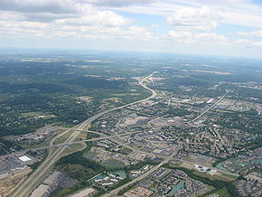
. Interstate 675 serves as an eastern bypass of Dayton. I-675 measures 26.53 miles (42.7 km) in length. As originally proposed, the route was to reconnect with I-75 north of Dayton near Northridge
Northridge, Montgomery County, Ohio
Northridge is an unincorporated area in Harrison Township in Montgomery County, Ohio, United States. It was delineated as a census-designated place for the 2000 census, at which time its population was 8,487. It was not delineated as a CDP for the 2010 census...
rather than going east towards Springfield
Springfield, Ohio
Springfield is a city in the U.S. state of Ohio and the county seat of Clark County. The municipality is located in southwestern Ohio and is situated on the Mad River, Buck Creek and Beaver Creek, approximately west of Columbus and northeast of Dayton. Springfield is home to Wittenberg...
and I-70 (this was later rejected because part of the right-of-way would have gone through the Wright-Patterson Air Force Base
Wright-Patterson Air Force Base
Wright-Patterson Air Force Base is a United States Air Force base in Greene and Montgomery counties in the state of Ohio. It includes both Wright and Patterson Fields, which were originally Wilbur Wright Field and Fairfield Aviation General Supply Depot. Patterson Field is located approximately...
). Construction was completed in 1987, though some have lobbied to extend the highway west of Dayton.
Route description
From the north, the highway intersects with Interstate 70Interstate 70 in Ohio
In the U.S. state of Ohio, Interstate 70 provides access between Indiana and West Virginia.-Route description:Along its path through Ohio, Interstate 70 passes through the following counties: Preble, Montgomery, Clark, Madison, Franklin, Fairfield, Licking, Muskingum, Guernsey and Belmont County...
near Fairborn
Fairborn, Ohio
Fairborn is a city in Greene County, Ohio, United States, near Dayton and Wright-Patterson Air Force Base. The population was 32,352 at the 2010 census...
where it starts as a four-lane highway. The highway opens to six lanes just after the intersection with N. Fairfield Rd. in Beavercreek
Beavercreek, Ohio
Beavercreek is the largest city in Greene County, Ohio, United States, and is the second largest suburb of Dayton behind Kettering. The population was 45,193 at the 2010 census. It is part of the Dayton Metropolitan Statistical Area...
. The next major junction is made with U.S. Route 35
U.S. Route 35
U.S. Route 35 is a north–south United States highway that runs northwest-southeast for approximately from northern Indiana to the western suburbs of Charleston, West Virginia. The highway's northern terminus is in Michigan City, Indiana, at U.S. Route 20. Its southern terminus is in Scott...
which is a full-access interchange. The highway continues with three lanes each way and ends at Interstate 75
Interstate 75 in Ohio
In the U.S. state of Ohio, Interstate 75 runs from Cincinnati to Toledo by way of Dayton. I-75 enters Ohio concurrent with I-71 from Kentucky on the Brent Spence Bridge over the Ohio River and into the Bluegrass region...
in Miami Township
Miami Township, Montgomery County, Ohio
Miami Township is one of the nine townships of Montgomery County, Ohio, United States. As of the 2010 census the population was 50,735.-Geography:Located in the southern part of the county, it borders the following townships and cities:*Moraine - north...
.
Exit list
| County | Location | Mile | # Exit number An exit number is a number assigned to a road junction, usually an exit from a freeway. It is usually marked on the same sign as the destinations of the exit, as well as a sign in the gore.... |
Destinations | Notes |
|---|---|---|---|---|---|
| Montgomery Montgomery County, Ohio Montgomery County is a county located in the state of Ohio, United States. The population was 535,153 in the 2010 Census. It was named in honor of Richard Montgomery, an American Revolutionary War general killed in 1775 while attempting to capture Quebec City, Canada. The county seat is Dayton... |
Miamisburg Miamisburg, Ohio Miamisburg is a city in Montgomery County, Ohio, United States. The population was 20,181 at the 2010 census. It is part of the Dayton Metropolitan Statistical Area... |
0.00 | Southbound exit and northbound entrance | ||
| 1.64 | 2 | ||||
| Centerville Centerville, Ohio Centerville, Ohio is a city in Montgomery and Greene Counties in the U.S. state of Ohio.Centerville, Ohio may also refer to:*Centerville, Gallia County, Ohio*Centerville, Clinton County, Ohio or Lees Creek... |
4.34 | 4 | Signed as exits 4A (south) and 4B (north) northbound | ||
| 6.96 | 7 | Wilmington Pike - Bellbrook Bellbrook, Ohio Bellbrook is a city in Greene County, Ohio, United States. The population was 6,943 at the 2010 census. It is part of the Dayton Metropolitan Statistical Area.-History:Bellbrook was first settled in 1814... |
|||
| Greene Greene County, Ohio Greene County is a county located in the state of Ohio, United States. The population was 161,573 in the 2010 Census. Its county seat is Xenia, and it was named for General Nathanael Greene, an officer in the Revolutionary War. Greene County was established on March 24, 1803.Greene County is part... |
Beavercreek Beavercreek, Ohio Beavercreek is the largest city in Greene County, Ohio, United States, and is the second largest suburb of Dayton behind Kettering. The population was 45,193 at the 2010 census. It is part of the Dayton Metropolitan Statistical Area... |
10.06 | 10 | Indian Ripple Road, Dorothy Lane - Kettering Kettering, Ohio As of the census of 2000, there were 57,502 people, 25,657 households, and 15,727 families residing in the city. The population density was 3,077.4 people per square mile . There were 26,936 housing units at an average density of 1,441.6 per square mile... |
|
| 12.88 | 13 | Signed as exits 13A (east) and 13B (west) | |||
| 15.19 | 15 | Colonel Glenn Highway - Wright-Patterson AFB Area B | |||
| Fairborn Fairborn, Ohio Fairborn is a city in Greene County, Ohio, United States, near Dayton and Wright-Patterson Air Force Base. The population was 32,352 at the 2010 census... |
15.91 | 16 | Grange Hall Road | Southbound exit and northbound entrance | |
| 17.23 | 17 | - Wright-Patterson AFB Areas A and C, & Wright State University Wright State University Wright State University is a comprehensive public university with strong doctoral, research, and undergraduate programs, rated among the 260 Best National Universities listed in the annual "America's Best Colleges" rankings by U.S. News and World Report. Wright State is located in Fairborn, Ohio,... |
|||
| 20.07 | 20 | Dayton-Yellow Springs Road | |||
| 22.38 | 22 | ||||
| Bath Township Bath Township, Greene County, Ohio Bath Township is one of the twelve townships of Greene County, Ohio, United States. The 2000 census found 40,231 people in the township, 8,877 of whom lived in the unincorporated portions of the township.-Geography:... |
24.50 | 24 | , Wright-Patterson AFB Areas A and C | ||
| Clark Clark County, Ohio As of the census of 2000, there were 144,742 people, 56,648 households, and 39,370 families residing in the county. The population density was 362 people per square mile . There were 61,056 housing units at an average density of 153 per square mile... |
Mad River Township Mad River Township, Clark County, Ohio Mad River Township is one of the ten townships of Clark County, Ohio, United States. The 2000 census found 11,828 people in the township, 9,190 of whom lived in the unincorporated portions of the township.-Geography:... |
25.91 | 26 | , Indianapolis Indianapolis, Indiana Indianapolis is the capital of the U.S. state of Indiana, and the county seat of Marion County, Indiana. As of the 2010 United States Census, the city's population is 839,489. It is by far Indiana's largest city and, as of the 2010 U.S... |
Signed as exits 26A (east) and 26B (west) |
| 26.43 | Spangler Road – Springfield Springfield, Ohio Springfield is a city in the U.S. state of Ohio and the county seat of Clark County. The municipality is located in southwestern Ohio and is situated on the Mad River, Buck Creek and Beaver Creek, approximately west of Columbus and northeast of Dayton. Springfield is home to Wittenberg... |
Northbound exit and southbound entrance (freeway ends; road becomes Spangler Road) |