
.gif)
Interstate 40 Business (North Carolina)
Encyclopedia
In the U.S. state
of North Carolina
, Interstate 40 Business (commonly known as "Business 40") is a 18.5 miles (29.8 km) business loop of Interstate 40
; which serves the cities of Winston-Salem
and Kernersville
.
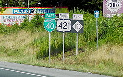
and exit 238 of US 421
in Winston-Salem. Traveling east, the route goes through the downtown of Winston-Salem, which has several quick on/off exits. It then continues south of Kernersville, before meeting back with Interstate 40
(exit 206) near Colfax. The entire route is 4-lane at freeway grade, it is also completely overlapped with US 421
.
. It opened in 1957, the freeway went from Stratford Road to Main Street, signed as US 158. In 1959, it was also signed as Interstate 40
. In 1960, it was extended east to Reidsville Road. By 1962, the freeway extended west to the current junction with US 421
and east into Guilford County
; it was also at that time when US 421
was rerouted from Reynolda Road to its current routing we see today.
Over the years, little has changed; which was a problem because the freeway was showing its age and was no longer considered interstate grade. In 1992, the state rerouted Interstate 40
onto a new bypass south of Winston-Salem. The old route was then renumbered as Interstate 40 Business. The freeway has made some repairs since then: In the late 1990s, the locally famous "Hawthorne Curve" near the North Carolina Baptist Hospital was rebuilt, softening the curve's angle. Other repairs were made on several exit ramps, roadbed grading, and bridges.

was rerouted onto new freeway south of Greensboro, becoming part of the Greensboro Urban Loop
. The old route through Greensboro was then renumbered as Business 40, treated as an extension from Colfax (hidden on main I-40, this is similar to how Business 85
is set up today in Greensboro). This extended the route 20 miles (32.2 km), ending at a new terminus at I-85
/I-40
, near McLeansville
.
However, NCDOT officials received a lot of complaints by local residents and motorists on the confusion between the new Interstate 40
and Business 40. Another issue was that funding for construction and repairs on the old route was slashed since it was no longer designated as an interstate. On September 12, 2008, with permission from FHWA, Interstate 40
was moved back to its old route through Greensboro, decommissioning Business 40 through Greensboro (basically existing for only seven months). By mid-2009, a majority of signs have been corrected, though there are still a few signs mislabeled.
, the roadway improvements and extension of Macy Grove Road will include the construction of a new interchange with I-40 Business/US 421
. Property acquisition is to begin in 2012.
In Winston-Salem
, shared with US 421
, a 1 miles (1.6 km) section from west of Fourth Street to east of Church Street has begun project development studies to completely upgrade and streamline. The project includes removing the existing pavement and replacing it with new concrete pavement, upgrade and modernize entrance and exit ramps, and replace most of the bridges on and over the freeway. No cost or time frame has been given at this time.
!County
!Location
!#
!Destinations
!Notes
|-
|rowspan=19|Forsyth
|rowspan=15|Winston-Salem
|style="background:#ddffdd"|1
|style="background:#ddffdd"|
|style="background:#ddffdd"|I-40 Business begins; north end of US 421 overlap, westbound exit and eastbound entrance
|-
|2
|
|Signed as exits 2A (south) and 2B (north)
|-
|3A
|Knollwood Street
|
|-
|style="background:#ddffdd"|3B
|style="background:#ddffdd"|
|style="background:#ddffdd"|West end of US 158 overlap; signed as exits 3B (south) and 3C (north) westbound
|-
|4A
|Cloverdale Avenue
|Signed as exit 4 eastbound
|-
|style="background:#ffdddd"|4B
|style="background:#ffdddd"|West First Street / Hawthorne Road
|style="background:#ffdddd"|Westbound exit and eastbound entrance
|-
|style="background:#ddffdd"|5A
|style="background:#ddffdd"|
|style="background:#ddffdd"|West end of NC 150 overlap
|-
|5B
|Broad Street – BB&T Ballpark
|Also to Downtown
|-
|5C
|Cherry Street – Convention Center
|Also to Downtown
|-
|5D
|Main Street / First Street – Old Salem
, Salem College
|Also to Downtown
|-
|6A-B
|, Smith Reynolds Airport
|Signed as exits 6A (south) and 6B (north)
|-
|6C
|Martin Luther King Jr. Drive – Winston-Salem State University
|
|-
|7
|Lowery Street / Fifth Street
|Eastbound Lowery Street, westbound Fifth Street
|-
|style="background:#ddffdd"|8
|style="background:#ddffdd"|
|style="background:#ddffdd"|East end of US 158 overlap; eastbound exit and westbound entrance
|-
|10
|Linville Road
|
|-
|rowspan=4|Kernersville
|14
|South Main Street
|
|-
|style="background:#ddffdd"|15
|style="background:#ddffdd"|
|style="background:#ddffdd"|East end of NC 150 overlap
|-
|style="background:#ffdddd"|16
|style="background:#ffdddd"|Mountain Street – Colfax
|style="background:#ffdddd"|Eastbound exit and westbound entrance
|-
|style="background:#ffdead"|
|style="background:#ffdead"|Macy Grove Road
|style="background:#ffdead"|Proposed new interchange (Currently in planning and environmental study)
|-
|Guilford
|Colfax
|style="background:#ddffdd"|
|style="background:#ddffdd"|
|style="background:#ddffdd"|I-40 Business ends; south end of US 421 overlap, eastbound exit and westbound entrance
|-
U.S. state
A U.S. state is any one of the 50 federated states of the United States of America that share sovereignty with the federal government. Because of this shared sovereignty, an American is a citizen both of the federal entity and of his or her state of domicile. Four states use the official title of...
of North Carolina
North Carolina
North Carolina is a state located in the southeastern United States. The state borders South Carolina and Georgia to the south, Tennessee to the west and Virginia to the north. North Carolina contains 100 counties. Its capital is Raleigh, and its largest city is Charlotte...
, Interstate 40 Business (commonly known as "Business 40") is a 18.5 miles (29.8 km) business loop of Interstate 40
Interstate 40 in North Carolina
Interstate 40 runs through the state of North Carolina from the Tennessee state line in the west to its eastern terminus in Wilmington.-Pigeon River Gorge:...
; which serves the cities of Winston-Salem
Winston-Salem, North Carolina
Winston-Salem is a city in the U.S. state of North Carolina, with a 2010 population of 229,617. Winston-Salem is the county seat and largest city of Forsyth County and the fourth-largest city in the state. Winston-Salem is the second largest municipality in the Piedmont Triad region and is home to...
and Kernersville
Kernersville, North Carolina
Kernersville is a town in Forsyth County in the U.S. state of North Carolina. The population was 17,126 at the 2000 census. In 2007 the U.S. Census estimated the town's population at 22,309. Kernersville is located at the heart of the Piedmont Triad metropolitan area, which consists of the cities...
.
Route description
Business 40 begins at exit 188 of Interstate 40Interstate 40 in North Carolina
Interstate 40 runs through the state of North Carolina from the Tennessee state line in the west to its eastern terminus in Wilmington.-Pigeon River Gorge:...
and exit 238 of US 421
U.S. Route 421 in North Carolina
U.S. Route 421 traverses approximately across North Carolina; from Fort Fisher, on a peninsula between the Atlantic and Cape Fear River, to the Tennessee state line near the community of Zionville....
in Winston-Salem. Traveling east, the route goes through the downtown of Winston-Salem, which has several quick on/off exits. It then continues south of Kernersville, before meeting back with Interstate 40
Interstate 40 in North Carolina
Interstate 40 runs through the state of North Carolina from the Tennessee state line in the west to its eastern terminus in Wilmington.-Pigeon River Gorge:...
(exit 206) near Colfax. The entire route is 4-lane at freeway grade, it is also completely overlapped with US 421
U.S. Route 421 in North Carolina
U.S. Route 421 traverses approximately across North Carolina; from Fort Fisher, on a peninsula between the Atlantic and Cape Fear River, to the Tennessee state line near the community of Zionville....
.
History
Winston-Salem
Originally known as the Downtown Expressway, it was one of the state's first urban freeways, predating the Interstate Highway SystemInterstate Highway System
The Dwight D. Eisenhower National System of Interstate and Defense Highways, , is a network of limited-access roads including freeways, highways, and expressways forming part of the National Highway System of the United States of America...
. It opened in 1957, the freeway went from Stratford Road to Main Street, signed as US 158. In 1959, it was also signed as Interstate 40
Interstate 40 in North Carolina
Interstate 40 runs through the state of North Carolina from the Tennessee state line in the west to its eastern terminus in Wilmington.-Pigeon River Gorge:...
. In 1960, it was extended east to Reidsville Road. By 1962, the freeway extended west to the current junction with US 421
U.S. Route 421 in North Carolina
U.S. Route 421 traverses approximately across North Carolina; from Fort Fisher, on a peninsula between the Atlantic and Cape Fear River, to the Tennessee state line near the community of Zionville....
and east into Guilford County
Guilford County, North Carolina
Guilford County is a county located in the U.S. state of North Carolina. In 2010, the Census Bureau estimated the county's population to be 491,230. Its seat is Greensboro. Since 1938, an additional county court has been located in High Point, North Carolina, making Guilford one of only a handful...
; it was also at that time when US 421
U.S. Route 421 in North Carolina
U.S. Route 421 traverses approximately across North Carolina; from Fort Fisher, on a peninsula between the Atlantic and Cape Fear River, to the Tennessee state line near the community of Zionville....
was rerouted from Reynolda Road to its current routing we see today.
Over the years, little has changed; which was a problem because the freeway was showing its age and was no longer considered interstate grade. In 1992, the state rerouted Interstate 40
Interstate 40 in North Carolina
Interstate 40 runs through the state of North Carolina from the Tennessee state line in the west to its eastern terminus in Wilmington.-Pigeon River Gorge:...
onto a new bypass south of Winston-Salem. The old route was then renumbered as Interstate 40 Business. The freeway has made some repairs since then: In the late 1990s, the locally famous "Hawthorne Curve" near the North Carolina Baptist Hospital was rebuilt, softening the curve's angle. Other repairs were made on several exit ramps, roadbed grading, and bridges.
Greensboro
In February 2008, Interstate 40Interstate 40 in North Carolina
Interstate 40 runs through the state of North Carolina from the Tennessee state line in the west to its eastern terminus in Wilmington.-Pigeon River Gorge:...
was rerouted onto new freeway south of Greensboro, becoming part of the Greensboro Urban Loop
Greensboro Urban Loop
The Greensboro Urban Loop is a planned 41-mile beltway around Greensboro, North Carolina, United States. The loop carries Interstate 85 and U.S. Route 421 on its southern section, and Interstate 73 from U.S. 220 to Bryan Boulevard along the west side of Greensboro...
. The old route through Greensboro was then renumbered as Business 40, treated as an extension from Colfax (hidden on main I-40, this is similar to how Business 85
Interstate 85 Business (North Carolina)
In the U.S. state of North Carolina, Interstate 85 Business is a business loop of Interstate 85; which serves several cities in the Piedmont Triad.-Route description:...
is set up today in Greensboro). This extended the route 20 miles (32.2 km), ending at a new terminus at I-85
Interstate 85 in North Carolina
In the U.S. state of North Carolina, Interstate 85 scales the state for from the South Carolina border to the Virginia border. As the second-longest interstate in the state , it provides an important link between the cities of Atlanta, Georgia, Charlotte, Greensboro, Richmond, Virginia and...
/I-40
Interstate 40 in North Carolina
Interstate 40 runs through the state of North Carolina from the Tennessee state line in the west to its eastern terminus in Wilmington.-Pigeon River Gorge:...
, near McLeansville
McLeansville, North Carolina
McLeansville is a census-designated place in Guilford County, North Carolina, United States. The population was 1,080 at the 2000 census. The community is most famous for being the hometown of American Idol contestant Chris Daughtry while he was on the show; he now lives in Oak Ridge, North...
.
However, NCDOT officials received a lot of complaints by local residents and motorists on the confusion between the new Interstate 40
Interstate 40 in North Carolina
Interstate 40 runs through the state of North Carolina from the Tennessee state line in the west to its eastern terminus in Wilmington.-Pigeon River Gorge:...
and Business 40. Another issue was that funding for construction and repairs on the old route was slashed since it was no longer designated as an interstate. On September 12, 2008, with permission from FHWA, Interstate 40
Interstate 40 in North Carolina
Interstate 40 runs through the state of North Carolina from the Tennessee state line in the west to its eastern terminus in Wilmington.-Pigeon River Gorge:...
was moved back to its old route through Greensboro, decommissioning Business 40 through Greensboro (basically existing for only seven months). By mid-2009, a majority of signs have been corrected, though there are still a few signs mislabeled.
Future
In KernersvilleKernersville, North Carolina
Kernersville is a town in Forsyth County in the U.S. state of North Carolina. The population was 17,126 at the 2000 census. In 2007 the U.S. Census estimated the town's population at 22,309. Kernersville is located at the heart of the Piedmont Triad metropolitan area, which consists of the cities...
, the roadway improvements and extension of Macy Grove Road will include the construction of a new interchange with I-40 Business/US 421
U.S. Route 421 in North Carolina
U.S. Route 421 traverses approximately across North Carolina; from Fort Fisher, on a peninsula between the Atlantic and Cape Fear River, to the Tennessee state line near the community of Zionville....
. Property acquisition is to begin in 2012.
In Winston-Salem
Winston-Salem, North Carolina
Winston-Salem is a city in the U.S. state of North Carolina, with a 2010 population of 229,617. Winston-Salem is the county seat and largest city of Forsyth County and the fourth-largest city in the state. Winston-Salem is the second largest municipality in the Piedmont Triad region and is home to...
, shared with US 421
U.S. Route 421 in North Carolina
U.S. Route 421 traverses approximately across North Carolina; from Fort Fisher, on a peninsula between the Atlantic and Cape Fear River, to the Tennessee state line near the community of Zionville....
, a 1 miles (1.6 km) section from west of Fourth Street to east of Church Street has begun project development studies to completely upgrade and streamline. The project includes removing the existing pavement and replacing it with new concrete pavement, upgrade and modernize entrance and exit ramps, and replace most of the bridges on and over the freeway. No cost or time frame has been given at this time.
Exit list
{| class=wikitable!County
!Location
!#
Exit number
An exit number is a number assigned to a road junction, usually an exit from a freeway. It is usually marked on the same sign as the destinations of the exit, as well as a sign in the gore....
!Destinations
!Notes
|-
|rowspan=19|Forsyth
Forsyth County, North Carolina
-Demographics:As of the census of 2000, there were 306,067 people, 123,851 households, and 81,741 families residing in the county. The population density was 747 people per square mile . There were 133,093 housing units at an average density of 325 per square mile...
|rowspan=15|Winston-Salem
Winston-Salem, North Carolina
Winston-Salem is a city in the U.S. state of North Carolina, with a 2010 population of 229,617. Winston-Salem is the county seat and largest city of Forsyth County and the fourth-largest city in the state. Winston-Salem is the second largest municipality in the Piedmont Triad region and is home to...
|style="background:#ddffdd"|1
|style="background:#ddffdd"|
|style="background:#ddffdd"|I-40 Business begins; north end of US 421 overlap, westbound exit and eastbound entrance
|-
|2
|
|Signed as exits 2A (south) and 2B (north)
|-
|3A
|Knollwood Street
|
|-
|style="background:#ddffdd"|3B
|style="background:#ddffdd"|
|style="background:#ddffdd"|West end of US 158 overlap; signed as exits 3B (south) and 3C (north) westbound
|-
|4A
|Cloverdale Avenue
|Signed as exit 4 eastbound
|-
|style="background:#ffdddd"|4B
|style="background:#ffdddd"|West First Street / Hawthorne Road
|style="background:#ffdddd"|Westbound exit and eastbound entrance
|-
|style="background:#ddffdd"|5A
|style="background:#ddffdd"|
|style="background:#ddffdd"|West end of NC 150 overlap
|-
|5B
|Broad Street – BB&T Ballpark
|Also to Downtown
|-
|5C
|Cherry Street – Convention Center
|Also to Downtown
|-
|5D
|Main Street / First Street – Old Salem
Old Salem
Old Salem is a historic district of Winston-Salem, North Carolina. It features a living history museum that interprets the restored Moravian community. The non-profit organization began its work in 1950, although some private residents had restored buildings earlier...
, Salem College
Salem College
Salem College is a liberal arts women's college in Winston-Salem, North Carolina founded in 1772. Originally established as a primary school, it later became an academy and finally a college. It is the oldest female educational establishment that is still a women's college...
|Also to Downtown
|-
|6A-B
|, Smith Reynolds Airport
Smith Reynolds Airport
Smith Reynolds Airport is a public airport located 3 miles northeast of the city of Winston-Salem in Forsyth County, North Carolina, USA. The airport has two runways, and is used primarily for general aviation and flight training, although some passenger operations take place there...
|Signed as exits 6A (south) and 6B (north)
|-
|6C
|Martin Luther King Jr. Drive – Winston-Salem State University
Winston-Salem State University
Winston-Salem State University , a constituent institution of the University of North Carolina, is a historically black public research university located in Winston-Salem, North Carolina, United States. It is a member school of the Thurgood Marshall Scholarship Fund.Winston-Salem State has been...
|
|-
|7
|Lowery Street / Fifth Street
|Eastbound Lowery Street, westbound Fifth Street
|-
|style="background:#ddffdd"|8
|style="background:#ddffdd"|
|style="background:#ddffdd"|East end of US 158 overlap; eastbound exit and westbound entrance
|-
|10
|Linville Road
|
|-
|rowspan=4|Kernersville
Kernersville, North Carolina
Kernersville is a town in Forsyth County in the U.S. state of North Carolina. The population was 17,126 at the 2000 census. In 2007 the U.S. Census estimated the town's population at 22,309. Kernersville is located at the heart of the Piedmont Triad metropolitan area, which consists of the cities...
|14
|South Main Street
|
|-
|style="background:#ddffdd"|15
|style="background:#ddffdd"|
|style="background:#ddffdd"|East end of NC 150 overlap
|-
|style="background:#ffdddd"|16
|style="background:#ffdddd"|Mountain Street – Colfax
Colfax, North Carolina
Colfax is a small unincorporated community located in Guilford County, North Carolina. As of the 2000 census, the CDP had a population of 2,469. Colfax is located at ....
|style="background:#ffdddd"|Eastbound exit and westbound entrance
|-
|style="background:#ffdead"|
|style="background:#ffdead"|Macy Grove Road
|style="background:#ffdead"|Proposed new interchange (Currently in planning and environmental study)
|-
|Guilford
Guilford County, North Carolina
Guilford County is a county located in the U.S. state of North Carolina. In 2010, the Census Bureau estimated the county's population to be 491,230. Its seat is Greensboro. Since 1938, an additional county court has been located in High Point, North Carolina, making Guilford one of only a handful...
|Colfax
Colfax, North Carolina
Colfax is a small unincorporated community located in Guilford County, North Carolina. As of the 2000 census, the CDP had a population of 2,469. Colfax is located at ....
|style="background:#ddffdd"|
|style="background:#ddffdd"|
|style="background:#ddffdd"|I-40 Business ends; south end of US 421 overlap, eastbound exit and westbound entrance
|-
Alternate names
Though the highway is simply known as Business 40 throughout the state, the highway does have other known names it uses locally in areas.- Downtown Expressway - Road name of first urban freeway in Winston-Salem, from Stratford Road to Main Street.
- East-West Expressway - Alternate Road name of Business 40 in Winston-Salem.