
Interstate 391
Encyclopedia
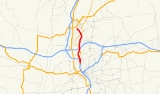
Interstate 391 is an Auxiliary Interstate Highway located entirely within the U.S. State
of Massachusetts
. It runs from the I-91/I-391 interchange in Chicopee
to the center of Holyoke
, a distance of about 4.86 mi (7.8 km). It runs near the Connecticut River
throughout its journey in Chicopee, and crosses into Holyoke and abruptly ends at High Street 0.4 mile (0.643736 km) south of U.S. Route 202
.
(at Exit 12) in southern Chicopee
, just north of the Atwater Park and the Calvary Cemetery. Initially running parallel to the Connecticut River
, it intersects with Route 116
in Chicopee center and crosses the Chicopee River
. I-391 then has another junction with Route 116 in the Sandy Hill section of town, and in less than one mile (1.6 km), it crosses underneath the Massachusetts Turnpike
without an interchange. I-391 continues north through the rest of northern Chicopee, intersecting Route 141
along the way and then passing just east of Rivers Park. I-391 then crosses the Connecticut River into the city of Holyoke
, where it has two closely spaced exits for local streets in the town. I-391 officially comes to an end at High Street in Holyoke, with the road continuing as Resnic Boulevard, which connects to US 202 after 0.4 mile (0.643736 km).
U.S. state
A U.S. state is any one of the 50 federated states of the United States of America that share sovereignty with the federal government. Because of this shared sovereignty, an American is a citizen both of the federal entity and of his or her state of domicile. Four states use the official title of...
of Massachusetts
Massachusetts
The Commonwealth of Massachusetts is a state in the New England region of the northeastern United States of America. It is bordered by Rhode Island and Connecticut to the south, New York to the west, and Vermont and New Hampshire to the north; at its east lies the Atlantic Ocean. As of the 2010...
. It runs from the I-91/I-391 interchange in Chicopee
Chicopee, Massachusetts
Chicopee is a city located on the Connecticut River in Hampden County, Massachusetts, United States of America. It is part of the Springfield, Massachusetts Metropolitan Statistical Area. As of the 2010 census, the city had a total population of 55,298, making it the second largest city in...
to the center of Holyoke
Holyoke, Massachusetts
Holyoke is a city in Hampden County, Massachusetts, United States, between the western bank of the Connecticut River and the Mount Tom Range of mountains. As of the 2010 Census, the city had a population of 39,880...
, a distance of about 4.86 mi (7.8 km). It runs near the Connecticut River
Connecticut River
The Connecticut River is the largest and longest river in New England, and also an American Heritage River. It flows roughly south, starting from the Fourth Connecticut Lake in New Hampshire. After flowing through the remaining Connecticut Lakes and Lake Francis, it defines the border between the...
throughout its journey in Chicopee, and crosses into Holyoke and abruptly ends at High Street 0.4 mile (0.643736 km) south of U.S. Route 202
U.S. Route 202
U.S. Route 202 is a highway stretching from Delaware to Maine, also passing through the states of Pennsylvania, New Jersey, New York, Connecticut, Massachusetts, and New Hampshire....
.
Route description
Interstate 391 begins at an interchange with I-91Interstate 91
Interstate 91 is an Interstate Highway in the New England region of the United States. It provides the primary north–south thoroughfare in the western part of New England...
(at Exit 12) in southern Chicopee
Chicopee, Massachusetts
Chicopee is a city located on the Connecticut River in Hampden County, Massachusetts, United States of America. It is part of the Springfield, Massachusetts Metropolitan Statistical Area. As of the 2010 census, the city had a total population of 55,298, making it the second largest city in...
, just north of the Atwater Park and the Calvary Cemetery. Initially running parallel to the Connecticut River
Connecticut River
The Connecticut River is the largest and longest river in New England, and also an American Heritage River. It flows roughly south, starting from the Fourth Connecticut Lake in New Hampshire. After flowing through the remaining Connecticut Lakes and Lake Francis, it defines the border between the...
, it intersects with Route 116
Massachusetts Route 116
Route 116 is a south–north state highway in Massachusetts. The route runs from Springfield through mill towns, college towns and rural towns, crossing the Connecticut River three times before finally ending in Adams.-Route description:...
in Chicopee center and crosses the Chicopee River
Chicopee River
The Chicopee River is an tributary of the Connecticut River in Metropolitan Springfield, Massachusetts, known for fast-moving water and its extraordinarily large basin: the Connecticut River's largest tributary basin...
. I-391 then has another junction with Route 116 in the Sandy Hill section of town, and in less than one mile (1.6 km), it crosses underneath the Massachusetts Turnpike
Massachusetts Turnpike
The Massachusetts Turnpike is the easternmost stretch of Interstate 90. The Turnpike begins at the western border of Massachusetts in West Stockbridge connecting with the Berkshire Connector portion of the New York State Thruway...
without an interchange. I-391 continues north through the rest of northern Chicopee, intersecting Route 141
Massachusetts Route 141
Route 141 is a west–east state highway in the U.S. state of Massachusetts. Its western terminus is at Route 10 in Easthampton. Its eastern terminus is at U.S...
along the way and then passing just east of Rivers Park. I-391 then crosses the Connecticut River into the city of Holyoke
Holyoke, Massachusetts
Holyoke is a city in Hampden County, Massachusetts, United States, between the western bank of the Connecticut River and the Mount Tom Range of mountains. As of the 2010 Census, the city had a population of 39,880...
, where it has two closely spaced exits for local streets in the town. I-391 officially comes to an end at High Street in Holyoke, with the road continuing as Resnic Boulevard, which connects to US 202 after 0.4 mile (0.643736 km).
History
Plans for the highway originated from the Master Highway Plan for the Springfield Metropolitan Area in 1953, which planned for a "major street improvement" to Route 116. By the 1960s, freeway access was needed between Chicopee and Holyoke to improve traffic flow which prompted a spur route of Interstate 91 to be built. I-391's planned six lanes were built to handle up to 50,000 vehicles every day, and the total cost of the proposed highway was estimated at about $35 million dollars. In 1965, an alignment of the highway had been set, along with two alternative alignments. Construction for Interstate 391 began in 1967 with a short 0.75 mi (1.2 km) long highway, which was completed in 1970. After years of no progress, construction started again in 1978. The highway was completed in 1982 after about 15 years of planning and construction.Exit list
| Location | Exit # Exit number An exit number is a number assigned to a road junction, usually an exit from a freeway. It is usually marked on the same sign as the destinations of the exit, as well as a sign in the gore.... |
Mile | Destinations | Notes |
|---|---|---|---|---|
| Chicopee Chicopee, Massachusetts Chicopee is a city located on the Connecticut River in Hampden County, Massachusetts, United States of America. It is part of the Springfield, Massachusetts Metropolitan Statistical Area. As of the 2010 census, the city had a total population of 55,298, making it the second largest city in... |
1A-B | 0.20 | , Hartford Hartford, Connecticut Hartford is the capital of the U.S. state of Connecticut. The seat of Hartford County until Connecticut disbanded county government in 1960, it is the second most populous city on New England's largest river, the Connecticut River. As of the 2010 Census, Hartford's population was 124,775, making... |
Southbound junction only. |
| 2 | 0.65 | Elms College Elms College The College of Our Lady of the Elms, often called Elms College, is a Catholic liberal arts college located in Chicopee, Massachusetts, near Springfield.- History :... |
||
| 3 | 1.60 | Westover Air Reserve Base | ||
| 4 | 3.56 | Split into 4A-B southbound. | ||
| Holyoke Holyoke, Massachusetts Holyoke is a city in Hampden County, Massachusetts, United States, between the western bank of the Connecticut River and the Mount Tom Range of mountains. As of the 2010 Census, the city had a population of 39,880... |
5 | 4.55 | Main Street | Northbound exit/southbound entrance only. |
| 6 | 4.78 | Commercial Street | Northbound exit/southbound entrance only.Mainline continues to High St./Resnic Blvd. | |
| 4.86 | High Street and Resnic Boulevard. | At-grade intersection |