
.gif)
Interstate 229 (Missouri)
Encyclopedia
Interstate 229 in the state of Missouri
, USA, is an approximately 14 mile (22.5 km) Interstate Highway spur designed to speed traffic from Interstate 29 to downtown Saint Joseph
.
The interstate, which was built in the late 1970s and early 1980s (with the southern section from downtown completed in 1979 and the northern section from downtown to the northern portion of I-29 completed in 1986), was intended to revive St. Joseph's downtown which had been seeing its businesses migrate to shopping mall
s along U.S. Route 169 (also known as the Belt Highway) about two miles (3 km) east of downtown near I-29. I-29 initially had been designed to bypass developed areas of St. Joseph but its construction spurred development near the interstate on the city's east side.
Access to St. Joseph's downtown business district earlier had been via residential streets often on a confusing maze of one-way streets.
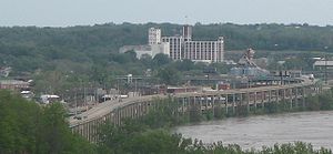
The most dramatic and controversial section of the road is a two-level viaduct
(with northbound cars on the top) on the west side of downtown separating the town from the Missouri River
. Its construction caused several historic downtown buildings to be torn down including portions of Robidoux Row
(built by the city's founder Joseph Robidoux
).http://www.modot.org/interstate/MissourisInterstateHistory.htm
Missouri
Missouri is a US state located in the Midwestern United States, bordered by Iowa, Illinois, Kentucky, Tennessee, Arkansas, Oklahoma, Kansas and Nebraska. With a 2010 population of 5,988,927, Missouri is the 18th most populous state in the nation and the fifth most populous in the Midwest. It...
, USA, is an approximately 14 mile (22.5 km) Interstate Highway spur designed to speed traffic from Interstate 29 to downtown Saint Joseph
Saint Joseph, Missouri
Saint Joseph is the second largest city in northwest Missouri, only second to Kansas City in size, serving as the county seat for Buchanan County. As of the 2010 census, Saint Joseph had a total population of 76,780, making it the eighth largest city in the state. The St...
.
The interstate, which was built in the late 1970s and early 1980s (with the southern section from downtown completed in 1979 and the northern section from downtown to the northern portion of I-29 completed in 1986), was intended to revive St. Joseph's downtown which had been seeing its businesses migrate to shopping mall
Shopping mall
A shopping mall, shopping centre, shopping arcade, shopping precinct or simply mall is one or more buildings forming a complex of shops representing merchandisers, with interconnecting walkways enabling visitors to easily walk from unit to unit, along with a parking area — a modern, indoor version...
s along U.S. Route 169 (also known as the Belt Highway) about two miles (3 km) east of downtown near I-29. I-29 initially had been designed to bypass developed areas of St. Joseph but its construction spurred development near the interstate on the city's east side.
Access to St. Joseph's downtown business district earlier had been via residential streets often on a confusing maze of one-way streets.
The most dramatic and controversial section of the road is a two-level viaduct
Viaduct
A viaduct is a bridge composed of several small spans. The term viaduct is derived from the Latin via for road and ducere to lead something. However, the Ancient Romans did not use that term per se; it is a modern derivation from an analogy with aqueduct. Like the Roman aqueducts, many early...
(with northbound cars on the top) on the west side of downtown separating the town from the Missouri River
Missouri River
The Missouri River flows through the central United States, and is a tributary of the Mississippi River. It is the longest river in North America and drains the third largest area, though only the thirteenth largest by discharge. The Missouri's watershed encompasses most of the American Great...
. Its construction caused several historic downtown buildings to be torn down including portions of Robidoux Row
Robidoux Row
Robidoux Row was an apartment building built by St. Joseph, Missouri founder Joseph Robidoux in north St. Joseph in the late 1840s/early 1850s. Robidoux lived there at one point....
(built by the city's founder Joseph Robidoux
Joseph Robidoux
Joseph Robidoux III established the Blacksnake Hills Trading Post that eventually became St. Joseph, Missouri.-Biography:...
).http://www.modot.org/interstate/MissourisInterstateHistory.htm
Exit list
| County | Location | # Exit number An exit number is a number assigned to a road junction, usually an exit from a freeway. It is usually marked on the same sign as the destinations of the exit, as well as a sign in the gore.... |
Destinations | Notes |
|---|---|---|---|---|
| Buchanan County | , Council Bluffs | Southbound exit and northbound entrance | ||
| Southbound exit and northbound entrance | ||||
| 1D | Northbound exit and southbound entrance | |||
| St. Joseph | 3 | |||
| 4 | East Lake Blvd | Northbound exit and southbound entrance | ||
| 4A | South end of US 59 overlap; southbound exit and northbound entrance | |||
| 4B | - Kansas Kansas Kansas is a US state located in the Midwestern United States. It is named after the Kansas River which flows through it, which in turn was named after the Kansa Native American tribe, which inhabited the area. The tribe's name is often said to mean "people of the wind" or "people of the south... , Cameron |
Northbound exit and southbound entrance | ||
| 4B | Southbound exit and northbound entrance | |||
| 5 | Southbound exit and northbound entrance | |||
| 6A | Edmond St - St. Joseph Central Business District | Northbound exit and southbound entrance | ||
| 6A | Felix St | Southbound exit and northbound entrance | ||
| 6B | North end of US 59 overlap; northbound exit and southbound entrance | |||
| 7 | Highland Ave | |||
| Andrew County | 11 | |||
| 14A | Northbound exit and southbound entrance | |||
| 14B | Northbound exit and southbound entrance | |||
| 14C | - Council Bluffs | Northbound exit and southbound entrance |