

Industrial District, Seattle, Washington
Encyclopedia
Seattle, Washington
Seattle is the county seat of King County, Washington. With 608,660 residents as of the 2010 Census, Seattle is the largest city in the Northwestern United States. The Seattle metropolitan area of about 3.4 million inhabitants is the 15th largest metropolitan area in the country...
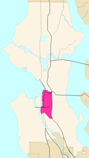
. It is bounded on the west by the Duwamish Waterway and Elliott Bay
Elliott Bay
Elliott Bay is the body of water on which Seattle, Washington, is located. A line drawn from Alki Point in the south to West Point in the north serves to mark the generally accepted division between the bay and the open sound...
, beyond which lies Delridge
Delridge, Seattle, Washington
Delridge is a district in West Seattle, Washington that stretches along Delridge Way, an arterial that follows the eastern slope of the valley of Longfellow Creek, from near its source just within the southern city limits north to the West Seattle Bridge over the Duwamish River.The Delridge...
of West Seattle; on the east by Interstate 5
Interstate 5
Interstate 5 is the main Interstate Highway on the West Coast of the United States, running largely parallel to the Pacific Ocean coastline from Canada to Mexico . It serves some of the largest cities on the U.S...
, beyond which lies Beacon Hill
Beacon Hill, Seattle, Washington
Beacon Hill is a hill and neighborhood in southeast Seattle, Washington. The municipal government subdivides it into North Beacon Hill, Mid-Beacon Hill, Holly Park, and South Beacon Hill, though most people who live there simply call it "Beacon Hill." Home to the world headquarters of Amazon.com...
; on the north by S King and S Dearborn Streets, beyond which lie Pioneer Square
Pioneer Square, Seattle, Washington
Pioneer Square is a neighborhood in the southwest corner of Downtown Seattle, Washington, USA. It was once the heart of the city: Seattle's founders settled there in 1852, following a brief six-month settlement at Alki Point on the far side of Elliott Bay. The early structures in the neighborhood...
and southwest International District
International District, Seattle, Washington
The Chinatown-International District of Seattle, Washington is an ethnic enclave neighborhood and is the center of Seattle's Asian American community. The neighborhood is multiethnic, consisting mainly of people who are of Chinese, Japanese, and Filipino ethnicity...
of Downtown
Downtown Seattle
Downtown is the central business district of Seattle, Washington. It is fairly compact compared to other city centers on the West Coast because of its geographical situation: hemmed in on the north and east by hills, on the west by the Elliott Bay, and on the south by reclaimed land that was once...
; and on the south by the main lines of the BNSF Railway
BNSF Railway
The BNSF Railway is a wholly owned subsidiary of Berkshire Hathaway Inc., and is headquartered in Fort Worth, Texas. It is one of seven North American Class I railroads and the second largest freight railroad network in North America, second only to the Union Pacific Railroad, its primary...
and Union Pacific Railroad
Union Pacific Railroad
The Union Pacific Railroad , headquartered in Omaha, Nebraska, is the largest railroad network in the United States. James R. Young is president, CEO and Chairman....
, or about S Lucille Street, beyond which is Georgetown
Georgetown, Seattle, Washington
Georgetown is a neighborhood in Seattle, Washington, USA. It is bounded on the north by the mainlines of the BNSF Railway and Union Pacific Railroad, beyond which is the Industrial District; on the west by the Duwamish River, across which is South Park; on the east by Interstate 5, beyond which is...
. SoDo
SoDo, Seattle, Washington
SoDo is a neighborhood in Seattle, Washington, that makes up part of the city's Industrial District. It is bounded on the north by South King Street, beyond which is Pioneer Square; on the south by South Spokane Street, beyond which is more of the Industrial District; on the west by the Duwamish...
is the name of the northwest portion of the neighborhood, named for its being South of Downtown. SoDo is the location of Safeco Field
Safeco Field
Safeco Field is a retractable roof baseball stadium located in Seattle, Washington. The stadium, owned and operated by the Washington-King County Stadium Authority, is the home stadium of the Seattle Mariners of Major League Baseball and has a seating capacity of 47,878 for baseball...
, home of the Seattle Mariners
Seattle Mariners
The Seattle Mariners are a professional baseball team based in Seattle, Washington. Enfranchised in , the Mariners are a member of the Western Division of Major League Baseball's American League. Safeco Field has been the Mariners' home ballpark since July...
, and CenturyLink Field, home of the Seattle Seahawks
Seattle Seahawks
The Seattle Seahawks are a professional American football team based in Seattle, Washington. They are currently members of the Western Division of the National Football Conference in the National Football League . The team joined the NFL in 1976 as an expansion team...
and Seattle Sounders FC
Seattle Sounders FC
Seattle Sounders FC is an American professional soccer club based in Seattle, Washington. The club competes in Major League Soccer , the top professional soccer league in the United States and Canada. Sounders FC was established in November 2007 as a MLS expansion team, making it the 15th team in...
. CenturyLink Field was also the site of the former Kingdome
Kingdome
The Kingdome was a multi-purpose stadium located in Seattle's SoDo neighborhood. Owned and operated by King County, the Kingdome opened in 1976 and was best known as the home stadium of the Seattle Seahawks of the National Football League , the Seattle Mariners of Major League Baseball , and the...
.
Most of the Industrial District is built on what was once the mudflat
Mudflat
Mudflats or mud flats, also known as tidal flats, are coastal wetlands that form when mud is deposited by tides or rivers. They are found in sheltered areas such as bays, bayous, lagoons, and estuaries. Mudflats may be viewed geologically as exposed layers of bay mud, resulting from deposition of...
s and lowlands of Elliott Bay and the Duwamish estuary
Estuary
An estuary is a partly enclosed coastal body of water with one or more rivers or streams flowing into it, and with a free connection to the open sea....
, dredged, straightened, and filled 1902 and 1907. Much of the area is also built on landfill which is prone to liquefaction
Liquefaction
Liquefaction may refer to:* Liquefaction, the general process of becoming liquid* Soil liquefaction, the process by which sediments become suspended* Liquefaction of gases in physics, chemistry, and thermal engineering* Liquefactive necrosis in pathology...
. This makes buildings in this area highly prone to earthquake damage.
Principal arterials are 1st and 4th avenues S, the Alaskan Way Viaduct
Alaskan Way Viaduct
The Alaskan Way Viaduct, completed on April 4, 1953, is a double-decked elevated section of State Route 99 that runs along the Elliott Bay waterfront in Seattle's Industrial District and downtown Seattle. It is the smaller of the two major north–south traffic corridors through Seattle ,...
, East Marginal and Airport ways S (north- and southbound); and S Spokane, the Spokane Street Viaduct, West Seattle Bridge
West Seattle Bridge
The high-level West Seattle Bridge is a cantilevered segmental bridge that serves as the primary connection between West Seattle and the rest of the city. It was built between 1981 and 1984 after the previous bascule bridge was deemed inoperable as a result of being struck by the Chavez freighter...
, and S Royal Brougham Way (east- and westbound). Minor arterials are 6th Avenue S, S Holgate and S Lander streets, and S Industrial Way.
History
What is now Seattle has been inhabited since the end of the last glacial period (c. 8,000 BCE—10,000 years ago). For example, the villages of tohl-AHL-too ("herringHerring
Herring is an oily fish of the genus Clupea, found in the shallow, temperate waters of the North Pacific and the North Atlantic oceans, including the Baltic Sea. Three species of Clupea are recognized. The main taxa, the Atlantic herring and the Pacific herring may each be divided into subspecies...
house") and later hah-AH-poos ("where there are horse clam
Horse clam
The horse clam are related to the Geoduck, though smaller, with shells up to eight inches long , weight to 3–4 lb . Two similar species of horse clams inhabit the Pacific coast intertidal zones: the pacific gaper, Tresus nuttallii, more abundant south to California; and the fat gaper, T...
s") at the then-mouth of the Duwamish River in what is now the Industrial District, had been inhabited since the 6th century CE. The Dkhw’Duw’Absh and Xacuabš
("People of the Inside" and "People of the Large Lake", now the Duwamish tribe) of the Lushootseed (Whulshootseed, Skagit-Nisqually)
Lushootseed
Lushootseed is the language or dialect continuum of several SalishNative American groups of modern-day Washington state...
Coast Salish
Coast Salish
Coast Salish languages are a subgroup of the Salishan language family. These languages are spoken by First Nations or Native American peoples inhabiting the territory that is now the southwest coast of British Columbia around the Strait of Georgia and Washington state around Puget Sound...
nations inhabited at least 17 villages in the mid-1850s, living in some 93 permanent longhouses
Native American long house
Longhouses were built by native peoples in various parts of North America, sometimes reaching over but generally around wide. The dominant theory is that walls were made of sharpened and fire-hardened poles driven into the ground and the roof consisted of leaves and grass...
(khwaac'ál'al) along Elliott Bay
Elliott Bay
Elliott Bay is the body of water on which Seattle, Washington, is located. A line drawn from Alki Point in the south to West Point in the north serves to mark the generally accepted division between the bay and the open sound...
, Salmon Bay
Salmon Bay
Salmon Bay is that part of the Lake Washington Ship Canal--which passes through the city of Seattle, linking Lake Washington to Puget Sound--that lies west of the Fremont Cut. It is the westernmost section of the canal, and empties into Shilshole Bay, which is part of Puget Sound. Because of the...
, Portage Bay
Portage Bay
Portage Bay is an arm of Seattle, Washington's Lake Union and is part of the Lake Washington Ship Canal. Its western limit can be said to be the Ship Canal Bridge, which carries Interstate 5 over the water; North Passage Point Park and South Passage Point Park sit on opposite shores between the...
, Lake Washington
Lake Washington
Lake Washington is a large freshwater lake adjacent to the city of Seattle. It is the largest lake in King County and the second largest in the state of Washington, after Lake Chelan. It is bordered by the cities of Seattle on the west, Bellevue and Kirkland on the east, Renton on the south and...
, Lake Sammamish
Lake Sammamish
Lake Sammamish is a freshwater lake east of Seattle in King County, Washington, United States. The lake is long and wide, with a maximum depth of and a surface area of . It lies east of Lake Washington and west of the Sammamish Plateau, and stretches from Issaquah in the south to Redmond in...
, and the Duwamish
Duwamish River
The Duwamish River is the name of the lower of Washington state's Green River. Its industrialized estuary is known as the Duwamish Waterway.- History :...
, Black
Black River (Duwamish River)
The Black River, also known as the Duwamish River, was a river in King County in the U.S. state of Washington. It drained Lake Washington until 1916 when the opening of the Lake Washington Ship Canal lowered the lake, causing the Black River to dry up...
, and Cedar
Cedar River (Washington)
The Cedar River is a river in the U.S. state of Washington. About long, it originates in the Cascade Range and flows generally west and northwest, emptying into the southern end of Lake Washington...
rivers.
In 1905 the Seattle Box Company relocated to the southeast corner of 4th Avenue S and S Spokane Street becoming one of the first residents of the Industrial District.
Starbucks
Starbucks
Starbucks Corporation is an international coffee and coffeehouse chain based in Seattle, Washington. Starbucks is the largest coffeehouse company in the world, with 17,009 stores in 55 countries, including over 11,000 in the United States, over 1,000 in Canada, over 700 in the United Kingdom, and...
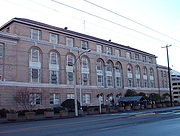
moved its world headquarters to the Industrial District in 1997, occupying the 1912 building
Starbucks Center
The Starbucks Center, world headquarters for Starbucks, is the largest multi-tenant building by floor space in Seattle, Washington, with over . It is located in Seattle's SoDo neighborhood, which makes up a part of the city's large industrial district...
constructed for Sears, Roebuck and Company
Sears, Roebuck and Company
Sears, officially named Sears, Roebuck and Co., is an American chain of department stores which was founded by Richard Warren Sears and Alvah Curtis Roebuck in the late 19th century...
as a catalog distribution center.
Some current industrial business owners are concerned about the future of the Industrial District.
The area is seen by some city developers as an ideal zone in which to expand non-industrial businesses and residential land use south of Downtown Seattle
Downtown Seattle
Downtown is the central business district of Seattle, Washington. It is fairly compact compared to other city centers on the West Coast because of its geographical situation: hemmed in on the north and east by hills, on the west by the Elliott Bay, and on the south by reclaimed land that was once...
.