
Indiana State Road 352
Encyclopedia
State Road 352 in the U.S. state
of Indiana
is an east–west state highway
in Benton County
in the west-central part of the state.
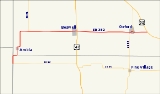
and Illinois Route 9
meet. It first winds north for about four miles (6 km), making two half-mile jogs to the east and passing through the small town of Ambia
. It then proceeds directly east, passing the southern terminus of State Road 71
after one mile (1.6 km). Six miles further to the east, it passes through the town of Boswell
and crosses U.S. Route 41
. After another seven miles (11 km), it passes through the town of Oxford
, where it crosses State Road 55
. The eastern terminus is at U.S. Route 52
, about a mile and a half east of Oxford.
U.S. state
A U.S. state is any one of the 50 federated states of the United States of America that share sovereignty with the federal government. Because of this shared sovereignty, an American is a citizen both of the federal entity and of his or her state of domicile. Four states use the official title of...
of Indiana
Indiana
Indiana is a US state, admitted to the United States as the 19th on December 11, 1816. It is located in the Midwestern United States and Great Lakes Region. With 6,483,802 residents, the state is ranked 15th in population and 16th in population density. Indiana is ranked 38th in land area and is...
is an east–west state highway
State highway
State highway, state road or state route can refer to one of three related concepts, two of them related to a state or provincial government in a country that is divided into states or provinces :#A...
in Benton County
Benton County, Indiana
Benton County is located along in the northwest part of the U.S. state of Indiana, along the border with Illinois. As of 2010, the county's population was 8,854. It contains six incorporated towns as well as several small unincorporated settlements; it is also divided into 11 townships which...
in the west-central part of the state.
Route description
The western terminus of State Road 352 is at the Illinois border where State Road 26Indiana State Road 26
State Road 26 is an east–west road in central Indiana in the United States that crosses the entire state from east to west, covering a distance of about .-Route description:...
and Illinois Route 9
Illinois Route 9
Illinois Route 9 is a cross-state, east–west rural state highway in central Illinois. It runs from the Fort Madison Toll Bridge over the Mississippi River to Iowa in Niota east to State Road 26 at the Indiana border. This is a distance of ....
meet. It first winds north for about four miles (6 km), making two half-mile jogs to the east and passing through the small town of Ambia
Ambia, Indiana
Ambia is a town in Hickory Grove Township, Benton County, Indiana, United States. The population was 239 at the 2010 census. It is part of the Lafayette, Indiana Metropolitan Statistical Area.-History:...
. It then proceeds directly east, passing the southern terminus of State Road 71
Indiana State Road 71
State Road 71 in west-central Indiana consists of two discontinuous north–south segments of two-lane rural roadway near the Illinois border.-Southern section:...
after one mile (1.6 km). Six miles further to the east, it passes through the town of Boswell
Boswell, Indiana
Boswell is a town in Grant Township, Benton County, Indiana, United States. The population was 778 at the 2010 census. It is part of the Lafayette, Indiana Metropolitan Statistical Area.-History:...
and crosses U.S. Route 41
U.S. Route 41
U.S. Route 41 is a north–south United States Highway that runs from Miami, Florida to the Upper Peninsula of Michigan. Until 1949, the part in southern Florida, from Naples to Miami, was U.S...
. After another seven miles (11 km), it passes through the town of Oxford
Oxford, Indiana
Oxford is a town in Oak Grove Township, Benton County, Indiana. The population was 1,162 at the 2010 census. It is part of the Lafayette, Indiana, Metropolitan Statistical Area.-History:...
, where it crosses State Road 55
Indiana State Road 55
State Road 55 is a north–south road in Northern and Central Indiana. State Road 55 runs from the Crawfordsville area in the south to Gary in the north, a distance of approximately .-Route description:...
. The eastern terminus is at U.S. Route 52
U.S. Route 52
U.S. Route 52 is a United States highway that runs across the northern, eastern and southeastern regions of the United States. Contrary to most other even-numbered U.S...
, about a mile and a half east of Oxford.