
Indiana State Road 69
Encyclopedia
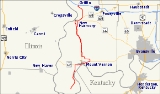
State Road 69 is a 35 miles (56.3 km) route that runs from south to north through western Posey County
in the southwestern corner of the U.S. state
of Indiana
.
in southwestern Posey County, near the confluence of the Ohio River
and the Wabash River
. It proceeds roughly northeast to Mount Vernon
, then goes north to New Harmony
on the Wabash River, and continues north to Griffin
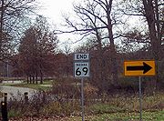
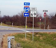
where it terminates at Interstate 64
. Because of its status as a connector between Southwind Maritime Centre and Interstate 64, State Road 69 has exceptionally wide shoulders throughout much of its route, especially in the section north of Mount Vernon.
From south to north, the highway serves the towns of Mount Vernon, Farmersville, Solitude, New Harmony, and Griffin.
Posey County, Indiana
As of the census of 2000, there were 27,061 people, 10,205 households, and 7,612 families residing in the county. The population density was 66 people per square mile . There were 11,076 housing units at an average density of 27 per square mile...
in the southwestern corner of the U.S. state
U.S. state
A U.S. state is any one of the 50 federated states of the United States of America that share sovereignty with the federal government. Because of this shared sovereignty, an American is a citizen both of the federal entity and of his or her state of domicile. Four states use the official title of...
of Indiana
Indiana
Indiana is a US state, admitted to the United States as the 19th on December 11, 1816. It is located in the Midwestern United States and Great Lakes Region. With 6,483,802 residents, the state is ranked 15th in population and 16th in population density. Indiana is ranked 38th in land area and is...
.
Route description
State Road 69 begins at the Hovey Lake Fish and Wildlife AreaHovey Lake Fish and Wildlife Area
Hovey Lake Fish and Wildlife Area is a nearly recreational area operated by the Indiana Department of Natural Resources near Mt. Vernon, Indiana....
in southwestern Posey County, near the confluence of the Ohio River
Ohio River
The Ohio River is the largest tributary, by volume, of the Mississippi River. At the confluence, the Ohio is even bigger than the Mississippi and, thus, is hydrologically the main stream of the whole river system, including the Allegheny River further upstream...
and the Wabash River
Wabash River
The Wabash River is a river in the Midwestern United States that flows southwest from northwest Ohio near Fort Recovery across northern Indiana to southern Illinois, where it forms the Illinois-Indiana border before draining into the Ohio River, of which it is the largest northern tributary...
. It proceeds roughly northeast to Mount Vernon
Mount Vernon, Indiana
Mount Vernon is a city in southern Indiana along the Ohio River and the county seat of Posey County. It is located in Black Township. As of the 2010 census, the city's population was 6,687...
, then goes north to New Harmony
New Harmony, Indiana
New Harmony is a historic town on the Wabash River in Harmony Township, Posey County, Indiana, United States. It lies north of Mount Vernon, the county seat. The population was 916 at the 2000 census. It is part of the Evansville metropolitan area. Many of the old Harmonist buildings still stand...
on the Wabash River, and continues north to Griffin
Griffin, Indiana
Griffin is a town in Bethel Township, Posey County, Indiana, United States, which was incorporated in 1881 and named after Samuel Griffin. The population was 172 at the 2010 census. The town was nearly destroyed by the Tri-State Tornado on March 18, 1925, killing 75 people...
where it terminates at Interstate 64
Interstate 64
Interstate 64 is an Interstate Highway in the Midwestern and Southeastern United States. Its western terminus is at I-70, U.S. 40, and U.S. 61 in Wentzville, Missouri. Its eastern terminus is at an interchange with I-264 and I-664 at Bowers Hill in Chesapeake, Virginia. As I-64 is concurrent with...
. Because of its status as a connector between Southwind Maritime Centre and Interstate 64, State Road 69 has exceptionally wide shoulders throughout much of its route, especially in the section north of Mount Vernon.
From south to north, the highway serves the towns of Mount Vernon, Farmersville, Solitude, New Harmony, and Griffin.
History
Originally, State Road 69 ran between New Harmony and Mount Vernon. Eventually it was connected to Interstate 64 at the Griffin exit and rerouted to bypass New Harmony. In Mount Vernon, State Road 69 was extended all the way down to Hovey Lake State Fish and Wildlife Area. In the late 1990s, the highway was routed onto the new William Keck Bypass on the eastern side of Mount Vernon.