

Griffin, Indiana
Encyclopedia
Griffin is a town in Bethel Township
, Posey County
, Indiana
, United States
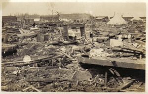
, which was incorporated in 1881 and named after Samuel Griffin. The population was 172 at the 2010 census. The town was nearly destroyed by the Tri-State Tornado
on March 18, 1925, killing 75 people. In 1972, a nearby outdoor rock concert Erie Canal Soda Pop Festival
caused quite a stir in the town over the course of three days. Locally, the fest was called the Bull Island rock fest, based on the location of the festival.
According to the United States Census Bureau
, the town has a total area of 0.1 square mile (0.258998811 km²), all of it land.
of 2000, there were 160 people, 73 households, and 42 families residing in the town. The population density
was 2,363.3 people per square mile (882.5/km²). There were 81 housing units at an average density of 1,196.4 per square mile (446.8/km²). The racial makeup of the town was 99.38% White, and 0.62% from two or more races.
There were 73 households out of which 17.8% had children under the age of 18 living with them, 52.1% were married couples
living together, 5.5% had a female householder with no husband present, and 41.1% were non-families. 34.2% of all households were made up of individuals and 26.0% had someone living alone who was 65 years of age or older. The average household size was 2.19 and the average family size was 2.84.
In the town the population was spread out with 19.4% under the age of 18, 8.8% from 18 to 24, 18.8% from 25 to 44, 33.1% from 45 to 64, and 20.0% who were 65 years of age or older. The median age was 47 years. For every 100 females there were 88.2 males. For every 100 females age 18 and over, there were 87.0 males.
The median income for a household in the town was $26,786, and the median income for a family was $42,083. Males had a median income of $28,125 versus $18,750 for females. The per capita income
for the town was $18,074. About 7.0% of families and 17.9% of the population were below the poverty line, including 40.7% of those under the age of eighteen and 22.2% of those sixty five or over.
Bethel Township, Posey County, Indiana
Bethel Township is one of ten townships in Posey County, Indiana. As of the 2000 census, its population was 327.-Adjacent Townships:*Indiana**Posey County***Robb Township**Gibson County***Wabash Township*Illinois...
, Posey County
Posey County, Indiana
As of the census of 2000, there were 27,061 people, 10,205 households, and 7,612 families residing in the county. The population density was 66 people per square mile . There were 11,076 housing units at an average density of 27 per square mile...
, Indiana
Indiana
Indiana is a US state, admitted to the United States as the 19th on December 11, 1816. It is located in the Midwestern United States and Great Lakes Region. With 6,483,802 residents, the state is ranked 15th in population and 16th in population density. Indiana is ranked 38th in land area and is...
, United States
United States
The United States of America is a federal constitutional republic comprising fifty states and a federal district...
, which was incorporated in 1881 and named after Samuel Griffin. The population was 172 at the 2010 census. The town was nearly destroyed by the Tri-State Tornado
Tri-State Tornado
The Tri-State Tornado of Wednesday, March 18, 1925, was the deadliest tornado in U.S. history. With 695 confirmed fatalities, the tornado killed more than twice as many as the second deadliest, the 1840 Great Natchez Tornado...
on March 18, 1925, killing 75 people. In 1972, a nearby outdoor rock concert Erie Canal Soda Pop Festival
Erie Canal Soda Pop Festival
The Erie Canal Soda Pop Festival was a rock festival held on the Labor Day weekend of 1972 near Griffin, Indiana on Bull Island, a strip of land in Illinois but, on the Indiana side of the Wabash River...
caused quite a stir in the town over the course of three days. Locally, the fest was called the Bull Island rock fest, based on the location of the festival.
Geography
Griffin is located at 38°12′16"N 87°54′54"W (38.204406, -87.915033).According to the United States Census Bureau
United States Census Bureau
The United States Census Bureau is the government agency that is responsible for the United States Census. It also gathers other national demographic and economic data...
, the town has a total area of 0.1 square mile (0.258998811 km²), all of it land.
Demographics
As of the censusCensus
A census is the procedure of systematically acquiring and recording information about the members of a given population. It is a regularly occurring and official count of a particular population. The term is used mostly in connection with national population and housing censuses; other common...
of 2000, there were 160 people, 73 households, and 42 families residing in the town. The population density
Population density
Population density is a measurement of population per unit area or unit volume. It is frequently applied to living organisms, and particularly to humans...
was 2,363.3 people per square mile (882.5/km²). There were 81 housing units at an average density of 1,196.4 per square mile (446.8/km²). The racial makeup of the town was 99.38% White, and 0.62% from two or more races.
There were 73 households out of which 17.8% had children under the age of 18 living with them, 52.1% were married couples
Marriage
Marriage is a social union or legal contract between people that creates kinship. It is an institution in which interpersonal relationships, usually intimate and sexual, are acknowledged in a variety of ways, depending on the culture or subculture in which it is found...
living together, 5.5% had a female householder with no husband present, and 41.1% were non-families. 34.2% of all households were made up of individuals and 26.0% had someone living alone who was 65 years of age or older. The average household size was 2.19 and the average family size was 2.84.
In the town the population was spread out with 19.4% under the age of 18, 8.8% from 18 to 24, 18.8% from 25 to 44, 33.1% from 45 to 64, and 20.0% who were 65 years of age or older. The median age was 47 years. For every 100 females there were 88.2 males. For every 100 females age 18 and over, there were 87.0 males.
The median income for a household in the town was $26,786, and the median income for a family was $42,083. Males had a median income of $28,125 versus $18,750 for females. The per capita income
Per capita income
Per capita income or income per person is a measure of mean income within an economic aggregate, such as a country or city. It is calculated by taking a measure of all sources of income in the aggregate and dividing it by the total population...
for the town was $18,074. About 7.0% of families and 17.9% of the population were below the poverty line, including 40.7% of those under the age of eighteen and 22.2% of those sixty five or over.
Highways
-
 Interstate 64
 -
 Indiana State Road 69Indiana State Road 69State Road 69 is a route that runs from south to north through western Posey County in the southwestern corner of the U.S. state of Indiana.-Route description:...