
Huggate
Encyclopedia
Huggate is a village and civil parish in the East Riding of Yorkshire
, England
. It is situated approximately 13 miles (20.9 km) north west of Beverley
town centre and 9 miles (14.5 km) west of Driffield
town centre. The village of North Dalton
lies 3.8 miles (6.1 km) to the south east.
 According to the 2001 UK census
, Huggate parish had a population of 317.
Huggate is the highest village on the Yorkshire Wolds
at around 558 feet (170 metres) above sea level at the south side and has one of the deepest wells in England. The village contains a pub
the Wolds Inn (on the Driffield road) which has two main rooms, a dining room and a lounge. It also has a beer garden with nice views. It serves food and welcomes walkers and cyclists.
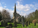
The parish church of St Mary is a Grade I listed building.
The Yorkshire Wolds Way
National Trail, a long distance footpath passes to the north of the village. There are walks through the local area, which is picturesque and often features steep-sided dales.
East Riding of Yorkshire
The East Riding of Yorkshire, or simply East Yorkshire, is a local government district with unitary authority status, and a ceremonial county of England. For ceremonial purposes the county also includes the city of Kingston upon Hull, which is a separate unitary authority...
, England
England
England is a country that is part of the United Kingdom. It shares land borders with Scotland to the north and Wales to the west; the Irish Sea is to the north west, the Celtic Sea to the south west, with the North Sea to the east and the English Channel to the south separating it from continental...
. It is situated approximately 13 miles (20.9 km) north west of Beverley
Beverley
Beverley is a market town, civil parish and the county town of the East Riding of Yorkshire, England, located between the River Hull and the Westwood. The town is noted for Beverley Minster and architecturally-significant religious buildings along New Walk and other areas, as well as the Beverley...
town centre and 9 miles (14.5 km) west of Driffield
Driffield
Driffield, also known as Great Driffield, is a market town and civil parish in the East Riding of Yorkshire, England. The civil parish is formed by the town of Driffield and the village of Little Driffield....
town centre. The village of North Dalton
North Dalton
North Dalton is a village and civil parish in the East Riding of Yorkshire, England. It is situated approximately south west of the town of Driffield and north east of the town of Pocklington. to the north west lies the village of Huggate. South Dalton actually lies some to the south east,...
lies 3.8 miles (6.1 km) to the south east.
United Kingdom Census 2001
A nationwide census, known as Census 2001, was conducted in the United Kingdom on Sunday, 29 April 2001. This was the 20th UK Census and recorded a resident population of 58,789,194....
, Huggate parish had a population of 317.
Huggate is the highest village on the Yorkshire Wolds
Yorkshire Wolds
The Yorkshire Wolds are low hills in the counties of East Riding of Yorkshire and North Yorkshire in northeastern England. The name also applies to the district in which the hills lie....
at around 558 feet (170 metres) above sea level at the south side and has one of the deepest wells in England. The village contains a pub
Public house
A public house, informally known as a pub, is a drinking establishment fundamental to the culture of Britain, Ireland, Australia and New Zealand. There are approximately 53,500 public houses in the United Kingdom. This number has been declining every year, so that nearly half of the smaller...
the Wolds Inn (on the Driffield road) which has two main rooms, a dining room and a lounge. It also has a beer garden with nice views. It serves food and welcomes walkers and cyclists.
The parish church of St Mary is a Grade I listed building.
The Yorkshire Wolds Way
Yorkshire Wolds Way
The Yorkshire Wolds Way is a National Trail in Yorkshire, England. It runs 79 miles from Hessle to Filey, around the Yorkshire Wolds...
National Trail, a long distance footpath passes to the north of the village. There are walks through the local area, which is picturesque and often features steep-sided dales.
External links
- Huggate Parish Website
- Wold's Villages Website - Huggate - St Mary's Church