
Homochitto River
Encyclopedia
The Homochitto River is a river
in the U.S. state
of Mississippi
. It flows from its source
in southwest Mississippi for about 90 miles (145 km) west and south, emptying into the Mississippi River
between Natchez
and Woodville
.
. It flows west and then south through the Homochitto National Forest
. After passing through Lincoln County the river enters Franklin County
, still flowing generally south.
Just before McCall Creek joins from the east, the Homochitto is crossed by two bridges, one for U.S. Route 84
and one for the Illinois Central Railroad
. Then the river begins to flow southwest, passing by the town of Bude
. Below Bude the river is crossed by U.S. Route 98
. Not far below that the river is joined by the Middle Fork Homochitto River, from the north. Several miles downriver from there the river becomes the boundary between Franklin County and Amite County
, at which point it begins to flow more directly westward. On the south side Amite County changes to Wilkinson County
just east of the town of Rosetta.
At Rosetta the river is crossed by two bridges, one for Mississippi Highway 33 and one for the Illinois Central Railroad. Still flowing westward, the river flows through a broad floodplain. Once highly meandering it has been straightened and channelized to a degree. On the north side Franklin County changes to Adams County
. Near the town of Doloroso the Homochitto River is crossed by U.S. Route 61
.
Below Doloroso the river originally flowed south, then west, to join the Mississippi River at Lake Mary, an Oxbow Lake formerly part of the main Mississippi channel. Today most of the Homochitto's water flows instead west from Doloroso, through the Abernathy Channel created in 1938 by the
United States Army Corps of Engineers
. Via this route the Homochitto River enters the Mississippi River several miles north of Lake Mary.
 In 1938 the United States Army Corps of Engineers
began channelizing the river by building the Abernathy Channel, a cutoff running from the Homochitto River near Doloroso
to the Mississippi River about 15 miles (24 km) upstream from where the Homochitto originally emptied into the Mississippi. This reduced the river's length below Doloroso from about 20 miles (32 km) of meander
ing distributaries
to a 9 miles (14 km) relatively straight outlet. Additional cutoffs between Doloroso and Rosetta were constructed in 1940, reducing the river's channel by about 4 miles (6 km). Other flood control projects on the lower Homochitto, completed in 1952, included the cleaning and desnagging of the main channel as well as the excavation of more cutoffs. All these projects were for the purpose of flood control along the lower Homochitto River.
Since the channelization projects were completed the lower Homochitto River and several of its tributaries have been degraded at an accelerated rate. The shortened channel has caused a greater streamflow velocity, increasing erosion and scour
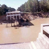
, which in turn causes bank sloughs and channel instability. Accelerated channel degradation probably began near the Mississippi River and moved up the Abernathy Channel during the early 1940s. It was noticeable at Doloroso by 1944 and at Kingston in 1947. Channel degradation at Rosetta began in the late 1940s. This acceleration erosional channel degradation resulted in the collapse of several bridges. In 1955 a flood washed out the old U.S. Highway 61 bridge at Kingston, the Illinois Central Railroad
bridge at Rosetta, and a country road bridge on the tributary Second Creek. In 1969 a bridge on the tributary Crooked Creek was washed out, and in 1971 the State Highway 33 bridge at Rosetta was washed out. During the flood of 1974 both the State Highway 33 bridge and the Illinois Central bridge at Rosetta were washed out.
River
A river is a natural watercourse, usually freshwater, flowing towards an ocean, a lake, a sea, or another river. In a few cases, a river simply flows into the ground or dries up completely before reaching another body of water. Small rivers may also be called by several other names, including...
in the U.S. state
U.S. state
A U.S. state is any one of the 50 federated states of the United States of America that share sovereignty with the federal government. Because of this shared sovereignty, an American is a citizen both of the federal entity and of his or her state of domicile. Four states use the official title of...
of Mississippi
Mississippi
Mississippi is a U.S. state located in the Southern United States. Jackson is the state capital and largest city. The name of the state derives from the Mississippi River, which flows along its western boundary, whose name comes from the Ojibwe word misi-ziibi...
. It flows from its source
Source (river or stream)
The source or headwaters of a river or stream is the place from which the water in the river or stream originates.-Definition:There is no universally agreed upon definition for determining a stream's source...
in southwest Mississippi for about 90 miles (145 km) west and south, emptying into the Mississippi River
Mississippi River
The Mississippi River is the largest river system in North America. Flowing entirely in the United States, this river rises in western Minnesota and meanders slowly southwards for to the Mississippi River Delta at the Gulf of Mexico. With its many tributaries, the Mississippi's watershed drains...
between Natchez
Natchez, Mississippi
Natchez is the county seat of Adams County, Mississippi, United States. With a total population of 18,464 , it is the largest community and the only incorporated municipality within Adams County...
and Woodville
Woodville, Mississippi
Woodville is a town in and the county seat of Wilkinson County, Mississippi, United States. The population was 1,192 at the 2000 census.The Woodville Republican, a weekly newspaper founded in 1823, is the oldest surviving business in Mississippi.-Geography:Woodville is located at .According to...
.
Course
The Homochitto River originates in several headwater tributaries along the border between Copiah County and Lincoln CountyLincoln County, Mississippi
-Demographics:As of the census of 2000, there were 33,166 people, 12,538 households, and 9,190 families residing in the county. The population density was 57 people per square mile . There were 14,052 housing units at an average density of 24 per square mile...
. It flows west and then south through the Homochitto National Forest
Homochitto National Forest
Homochitto National Forest is a U.S. National Forest in southwestern Mississippi comprising . In the mid-1930s, the Civilian Conservation Corps began reforestation of the area and developing a system of roadways and recreational areas.-Geography:...
. After passing through Lincoln County the river enters Franklin County
Franklin County, Mississippi
-Demographics:As of the census of 2000, there were 8,448 people, 3,211 households, and 2,337 families residing in the county. The population density was 15 people per square mile . There were 4,119 housing units at an average density of 7 per square mile...
, still flowing generally south.
Just before McCall Creek joins from the east, the Homochitto is crossed by two bridges, one for U.S. Route 84
U.S. Route 84
U.S. Route 84 is an east–west United States highway. It started as a short Georgia-Alabama route in the original 1926 scheme, but now extends all the way to Colorado. The highway's eastern terminus is a short distance east of Midway, Georgia, at an intersection with I-95. The road continues...
and one for the Illinois Central Railroad
Illinois Central Railroad
The Illinois Central Railroad , sometimes called the Main Line of Mid-America, is a railroad in the central United States, with its primary routes connecting Chicago, Illinois with New Orleans, Louisiana and Birmingham, Alabama. A line also connected Chicago with Sioux City, Iowa...
. Then the river begins to flow southwest, passing by the town of Bude
Bude, Mississippi
Bude is a town in Franklin County, Mississippi, United States. The population was 1,037 at the 2000 census.-Geography:Bude is located at .According to the United States Census Bureau, the town has a total area of , all of it land....
. Below Bude the river is crossed by U.S. Route 98
U.S. Route 98
U.S. Route 98 is an east–west United States highway that runs from western Mississippi to southern Florida. It was established in 1933 as a route between Pensacola, Florida and Apalachicola, Florida, and has since been extended westward into Mississippi and eastward across the Florida...
. Not far below that the river is joined by the Middle Fork Homochitto River, from the north. Several miles downriver from there the river becomes the boundary between Franklin County and Amite County
Amite County, Mississippi
-Demographics:As of the census of 2000, there were 13,599 people, 5,271 households, and 3,879 families residing in the county. The population density was 19 people per square mile . There were 6,446 housing units at an average density of 9 per square mile...
, at which point it begins to flow more directly westward. On the south side Amite County changes to Wilkinson County
Wilkinson County, Mississippi
-Demographics:As of the census of 2000, there were 10,312 people, 3,578 households, and 2,511 families residing in the county. The population density was 15 people per square mile . There were 5,106 housing units at an average density of 8 per square mile...
just east of the town of Rosetta.
At Rosetta the river is crossed by two bridges, one for Mississippi Highway 33 and one for the Illinois Central Railroad. Still flowing westward, the river flows through a broad floodplain. Once highly meandering it has been straightened and channelized to a degree. On the north side Franklin County changes to Adams County
Adams County, Mississippi
As of the census of 2000, there were 34,340 people, 13,677 households, and 9,409 families residing in the county. The population density was 75 people per square mile . There were 15,175 housing units at an average density of 33 per square mile...
. Near the town of Doloroso the Homochitto River is crossed by U.S. Route 61
U.S. Route 61
U.S. Route 61 is the official designation for a United States highway that runs from New Orleans, Louisiana, to the city of Wyoming, Minnesota. The highway generally follows the course of the Mississippi River, and is designated the Great River Road for much of its route. As of 2004, the highway's...
.
Below Doloroso the river originally flowed south, then west, to join the Mississippi River at Lake Mary, an Oxbow Lake formerly part of the main Mississippi channel. Today most of the Homochitto's water flows instead west from Doloroso, through the Abernathy Channel created in 1938 by the
United States Army Corps of Engineers
United States Army Corps of Engineers
The United States Army Corps of Engineers is a federal agency and a major Army command made up of some 38,000 civilian and military personnel, making it the world's largest public engineering, design and construction management agency...
. Via this route the Homochitto River enters the Mississippi River several miles north of Lake Mary.
River modification
United States Army Corps of Engineers
The United States Army Corps of Engineers is a federal agency and a major Army command made up of some 38,000 civilian and military personnel, making it the world's largest public engineering, design and construction management agency...
began channelizing the river by building the Abernathy Channel, a cutoff running from the Homochitto River near Doloroso
Doloroso, Mississippi
Doloroso, Mississippi, is a small unincorporated community in Wilkinson County, Mississippi, close to the county seat Woodville and to Homochitto National Forest....
to the Mississippi River about 15 miles (24 km) upstream from where the Homochitto originally emptied into the Mississippi. This reduced the river's length below Doloroso from about 20 miles (32 km) of meander
Meander
A meander in general is a bend in a sinuous watercourse. A meander is formed when the moving water in a stream erodes the outer banks and widens its valley. A stream of any volume may assume a meandering course, alternately eroding sediments from the outside of a bend and depositing them on the...
ing distributaries
Distributary
A distributary, or a distributary channel, is a stream that branches off and flows away from a main stream channel. They are a common feature of river deltas. The phenomenon is known as river bifurcation. The opposite of a distributary is a tributary...
to a 9 miles (14 km) relatively straight outlet. Additional cutoffs between Doloroso and Rosetta were constructed in 1940, reducing the river's channel by about 4 miles (6 km). Other flood control projects on the lower Homochitto, completed in 1952, included the cleaning and desnagging of the main channel as well as the excavation of more cutoffs. All these projects were for the purpose of flood control along the lower Homochitto River.
Since the channelization projects were completed the lower Homochitto River and several of its tributaries have been degraded at an accelerated rate. The shortened channel has caused a greater streamflow velocity, increasing erosion and scour
Bridge scour
Bridge scour is the removal of sediment such as sand and rocks from around bridge abutments or piers. Scour, caused by swiftly moving water, can scoop out scour holes, compromising the integrity of a structure....
, which in turn causes bank sloughs and channel instability. Accelerated channel degradation probably began near the Mississippi River and moved up the Abernathy Channel during the early 1940s. It was noticeable at Doloroso by 1944 and at Kingston in 1947. Channel degradation at Rosetta began in the late 1940s. This acceleration erosional channel degradation resulted in the collapse of several bridges. In 1955 a flood washed out the old U.S. Highway 61 bridge at Kingston, the Illinois Central Railroad
Illinois Central Railroad
The Illinois Central Railroad , sometimes called the Main Line of Mid-America, is a railroad in the central United States, with its primary routes connecting Chicago, Illinois with New Orleans, Louisiana and Birmingham, Alabama. A line also connected Chicago with Sioux City, Iowa...
bridge at Rosetta, and a country road bridge on the tributary Second Creek. In 1969 a bridge on the tributary Crooked Creek was washed out, and in 1971 the State Highway 33 bridge at Rosetta was washed out. During the flood of 1974 both the State Highway 33 bridge and the Illinois Central bridge at Rosetta were washed out.