
History of Rakhine
Encyclopedia
Rakhine people
The Rakhine , is a nationality in Myanmar forming the majority along the coastal region of present day Rakhine State or Arakan State. They possibly constitute 5.53% or more of Myanmar's total population but no accurate census figures exist. Rakhine people also live in the southeastern parts of...
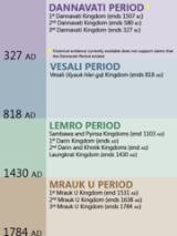
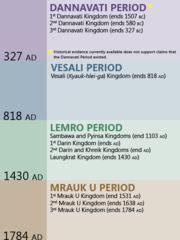
(Arakanese) claim a history that began in 3325 BC and certain archaeological evidence have been supposed to be found to support this claim.
According to legend, the first independent kingdom was established in 3325 BC by King Marayu. Buddhism was introduced into Rakhine during the lifetime of Buddha
Gautama Buddha
Siddhārtha Gautama was a spiritual teacher from the Indian subcontinent, on whose teachings Buddhism was founded. In most Buddhist traditions, he is regarded as the Supreme Buddha Siddhārtha Gautama (Sanskrit: सिद्धार्थ गौतम; Pali: Siddhattha Gotama) was a spiritual teacher from the Indian...
himself. According to Rakhine Chronicles, the Buddha in his lifetime, visited the city of Dhanyawadi
Dhanyawadi
Dhanyawadi was a town in Northern Rakhine State, Myanmar.The site is approximately 80 miles north by north east of Sittwe, and lies between the Kaladan River and Thare Chaung . Like much of Northern Rakhine State, it is in a hilly locale...
in 554 BC. King Sanda Thuriya requested the Buddha to leave an image of Himself. After casting the Great Image Maha Muni
Mahamuni Buddha
The Mahamuni Buddha Temple is a Buddhist temple and major pilgrimage site, located southwest of Mandalay, Burma . The Mahamuni Buddha image is deified in this temple, and originally came from Arakan...
, the Buddha breathed upon it which resembled the exact likeness of the Blessed One.
Dhanyawadi
Ancient Dhanyawadi lies west of the mountain ridge between the KaladanKaladan River
The Kaladan River is a river in eastern Mizoram State of India, and in Chin State and Rakhine State of western Myanmar. It forms the international border between India and Burma between 22° 47′ 10" N and 22° 11′ 06" N.-Geography:The river arises in central Chin State as the Timit, 22° 49′ 28″ N ...
and Le-mro rivers. Dhannyawadi could be reached by small boat from the Kaladan via its tributary, the Tharechaung. Its city walls were made of brick, and form an irregular circle with a perimeter of about 9.6 km, enclosing an area of about 4.42 square km. Beyond the walls, the remains of a wide moat, now silted over and covered by paddy fields, are still visible in places. The remains of brick fortifications can be seen along the hilly ridge which provided protection from the west. Within the city, a similar wall and moat enclose the palace site, which has an area of 0.26 square km, and another wall surrounds the palace itself.
At times of insecurity, when the city was subject to raids from the hill tribes or attempted invasions from neighboring powers, there would have been an assured food supply enabling the population to withstand a siege. The city would have controlled the valley and the lower ridges, supporting a mixed wet-rice and taungya (slash and burn) economy, with local chiefs paying allegiance to the king.
From aerial photographs we can discern Dhannyawadi's irrigation channels and storage tanks, centered at the palace site. Throughout the history of Rakhine, and indeed the rest of early Southeast Asia, the king's power stemmed from his control of irrigation and water storage systems to conserve the monsoon rains and therefore to maintain the fertility and prosperity of the land. In ceremonies conducted by Indian Brahmins the king was given the magic power to regulate the celestial and terrestrial forces in order to control the coming of the rains which would ensure the continuing prosperity of the kingdom.
Waithali
It has been estimated that the centre of power of the Arakanese world shifted from Dhanyawadi to Waithali in the 4th century AD. Although it was established later than Dhanyawadi, Waithali is the most Indianized of the four Arakanese kingdoms to emerge. Like all of the Arakanese Kingdoms to emerge, the Kingdom of Waithali was based on trade between the East (pre-Pagan Myanmar,Pyu, China, the Mons), and the West (India, Bengal, Persia).Anandachandra Inscriptions date back to 729 AD originally from Vesali now preserved at Shitethaung indicates adequate evidence for the earliest foundation of Buddhism and the subjects of the Waithali Kingdom practiced. Dr. E. H. Johnston's analysis reveals a list of kings which he considered reliable beginning from Chandra dynasty. The western face inscription has 72 lines of text recorded in 51 verses describing the Anandachandra's ancestral rulers. Each face recorded the name and ruling period of each king who were believed to have ruled over the land before Anandachandra.
Some important and badly damaged life-size Buddha images were recovered from Letkhat-Taung, a hill east of the old palace compound. These statues are invaluabe in helping to understand the Waithali architecture, and also the extent of Hindu influence in the kingdom.
According to local legend, Shwe-taung-gyi (lit. Great Golden Hill), a hill northeast of the palace compound maybe a burial place of a 10th century Pyu
Pyu
Pyu city states were a group of city-states that existed from c. 2nd century BCE to late 9th century CE in present-day Upper Burma . The city-states were founded as part of the southward migration by the Tibeto-Burman-speaking Pyu, the earliest inhabitants of Burma of whom records are extant...
king.
The rulers of the Waithali Kingdom were of the Chandra dynasty, because of their usage of Chandra on the Waithali coins. The Waithali period is seen by many as the beginning of Arakanese coinage - which was almost a millennium earlier than the Burmese. On the reverse of the coins, the Srivatsa
Srivatsa
The Śrīvatsa, Shrivatsa, or Sri Vatsa is a figure of South Asian symbology. Shrivatsa was married to Rudrani. Chandra et al.. state that it denotes "...the auspicious mark represented by a curled noose emblematical of love...".Shrivatsa is an ancient auspicious symbol in India...
(Arakanese/Burmese: Thiriwutsa), while the obverse bears a bull, the emblem of the Chandra dynasty, under which the name of the King is inscribed in Sanskrit.
Mrauk U
In 1433, King Min Saw Mon established Mrauk U as the capital of the last unified Arakanese KingdomRakhine State
Rakhine State is a Burmese state. Situated on the western coast, it is bordered by Chin State in the north, Magway Region, Bago Region and Ayeyarwady Region in the east, the Bay of Bengal to the west, and the Chittagong Division of Bangladesh to the northwest. It is located approximately between...
. The city eventually reached a size of 160,000 in the early seventeenth century. Mrauk U served as the capital of the Mrauk U kingdom and its 49 kings till the conquest of the kingdom by the Burmese Konbaung Dynasty
Konbaung dynasty
The Konbaung Dynasty was the last dynasty that ruled Burma from 1752 to 1885. The dynasty created the second largest empire in Burmese history, and continued the administrative reforms begun by the Toungoo dynasty, laying the foundations of modern state of Burma...
in 1784.
Trading City
Due to its proximity to the Bay of BengalBay of Bengal
The Bay of Bengal , the largest bay in the world, forms the northeastern part of the Indian Ocean. It resembles a triangle in shape, and is bordered mostly by the Eastern Coast of India, southern coast of Bangladesh and Sri Lanka to the west and Burma and the Andaman and Nicobar Islands to the...
, Mrauk U developed into an important regional trade hub, acting as both a back door to the Burmese hinterland and also as an important port along the eastern shore of the Bay of Bengal. It became a transit point for goods such as rice, ivory, elephants, tree sap and deer hide from Ava in Burma, and of cotton, slaves, horses, cowrie, spices and textiles from Bengal, India, Persia and Arabia. Alongside Pegu and later Syriam, it was one of the most important ports in Burma till the eighteenth century.
The city also traded with non-Asian powers such as Portugal
Portugal
Portugal , officially the Portuguese Republic is a country situated in southwestern Europe on the Iberian Peninsula. Portugal is the westernmost country of Europe, and is bordered by the Atlantic Ocean to the West and South and by Spain to the North and East. The Atlantic archipelagos of the...
and then the VOC
Dutch East India Company
The Dutch East India Company was a chartered company established in 1602, when the States-General of the Netherlands granted it a 21-year monopoly to carry out colonial activities in Asia...
of the Netherlands. The VOC established trading relations with the Arakanese in 1608 after the Portuguese fell in favour due to the lack of loyalty of Portuguese mercenaries, such as Filipe de Brito e Nicote in the service of the Arakanese king. The VOC established a permanent factory in Mrauk U in 1635, and operated in Arakan till 1665.
At its zenith
Zenith
The zenith is an imaginary point directly "above" a particular location, on the imaginary celestial sphere. "Above" means in the vertical direction opposite to the apparent gravitational force at that location. The opposite direction, i.e...
, Mrauk U was the centre of a kingdom which stretched from the shores of the Ganges river to the western reaches of the Ayeyarwaddy River. According to popular Arakanese legend, there were 12 'cities of the Ganges' which constitute roughly half of modern day Bangladesh which were governed by Mrauk U, including Dhaka
Dhaka
Dhaka is the capital of Bangladesh and the principal city of Dhaka Division. Dhaka is a megacity and one of the major cities of South Asia. Located on the banks of the Buriganga River, Dhaka, along with its metropolitan area, had a population of over 15 million in 2010, making it the largest city...
and Chittagong
Chittagong
Chittagong ) is a city in southeastern Bangladesh and the capital of an eponymous district and division. Built on the banks of the Karnaphuli River, the city is home to Bangladesh's busiest seaport and has a population of over 4.5 million, making it the second largest city in the country.A trading...
. During that period, its kings minted coins inscribed in Arakanese, Kufic
Kufic
Kufic is the oldest calligraphic form of the various Arabic scripts and consists of a modified form of the old Nabataean script. Its name is derived from the city of Kufa, Iraq, although it was known in Mesopotamia at least 100 years before the foundation of Kufa. At the time of the emergence of...
and Bengali
Bengali language
Bengali or Bangla is an eastern Indo-Aryan language. It is native to the region of eastern South Asia known as Bengal, which comprises present day Bangladesh, the Indian state of West Bengal, and parts of the Indian states of Tripura and Assam. It is written with the Bengali script...
. The inclusion of Kufic and Bengali were not that the Mrauk U kings had embraced Islam, but in order to gain legitimacy over the mainly Islamic Bengalis who were subjects.
Much of Mrauk U's historical description is drawn from the writings of Friar Sebastian Manrique, a Portuguese Augustinian
Augustinians
The term Augustinians, named after Saint Augustine of Hippo , applies to two separate and unrelated types of Catholic religious orders:...
monk who resided in Mrauk U from 1630 to 1635.
Colonial Period
The people of Rakhine (Arakan) resisted the conquest of the kingdom for decades after. Fighting with the Rakhine (Arakanese) resistance, initially led by Nga Than Dè and finally by Chin Byan in border areas, created problems between British India and Burma. The year 1826 saw the defeat of the Bamar in the First Anglo-Burmese War and Rakhine (Arakan) was ceded to Britain under the Treaty of YandaboTreaty of Yandabo
The Treaty of Yandabo was the peace treaty that ended the First Anglo-Burmese War. The treaty was signed on 24 February 1826, nearly two years after the war formally broke out on 5 March 1824, by General Sir Archibald Campbell on the British side, and by Governor of Legaing Maha Min Hla Kyaw Htin...
. Akyab was then designated the new capital of Rakhine (Arakan). In 1852, Rakhine (Arakan) was merged into Lower Burma
Lower Burma
Lower Burma is a geographic region of Burma and includes the low-lying Irrawaddy delta , as well as coastal regions of the country ....
as a territorial division.
Rakhine (Arakan) was the center of multiple insurgencies which fought against British rule, notably led by the monks U Ottama and U Seinda.
During the Second World War, Rakhine (Arakan) was given autonomy under the Japanese occupation and was even granted its own army known as the Arakan Defence Force. The Arakan Defence Force went over to the allies and turned against the Japanese in early 1945.
In 1948, Rakhine (Arakan) became a division within the Union of Burma. Shortly after, violence broke out along religious lines between Buddhists and Muslims. Later there were calls for secession by the Rakhine (Arakan), but such attempts were subdued. In 1974, the Ne Win
Ne Win
Ne Win was Burmese a politician and military commander. He was Prime Minister of Burma from 1958 to 1960 and 1962 to 1974 and also head of state from 1962 to 1981...
government's new constitution granted Rakhine (Arakan) Division "state" status but the gesture was largely seen as meaningless since the military junta held all power in the country and in Rakhine (Arakan). In 1989, the name of Arakan State was changed to "Rakhine" by the military junta.