
.gif)
Highway 141 (Ontario)
Encyclopedia
King's Highway 141, commonly known as Highway 141, is a provincially maintained highway in the Canadian
province of Ontario
. Its western terminus is at Highway 400 south of Horseshoe Lake in Seguin Township while its eastern terminus is at Highway 11 near Port Sydney. The route was designated in 1974 when Highway 532 was renumbered and upgraded from a secondary highway to a King's Highway. The route has remained generally unchanged since, though it was extended by several kilometres on October 7, 2003 when Highway 400 was extended north of Mactier.
 The total length of Highway 141 is presently 54.3 km. It travels through Muskoka District
and Parry Sound District
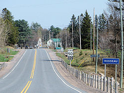
, travelling through the communities of Humphrey, Rosseau
, Bent River (off-route but nearby), Ullswater, Raymond and the small village of Utterson. The road passes several bodies of water including Lake Rosseau, Skeleton Lake, Longs Lake and others. Other lakes are accessible via Highway 141 including Three Mile Lake, Lake Joseph, Horse Lake and others.
Highway 141 is the first major highway connection between Highway 400 and Highway 11 north of Barrie and the Muskoka Lakes Region. The highway terminates at Exit 207 on both of these highways, and is the only highway in Ontario to begin and end at the same exit number
. On Highway 400, the Highway 141 junction is located near the Parry Sound Area Municipal Airport
. One kilometre east of that point, the highway meets and travels concurrently
with Highway 69
north for 3.5 kilometres (2.2 mi) before heading east towards Highway 11. Rosseau is the largest community located directly on the route.
On January 1, 1973, the route of Highway 532 was modified so that it continued east along the former Highway 516 instead of curving south through Bracebridge
.
This routing was short-lived; in 1974 the Ministry of Transportation and Communications redesignated the entirety of Highway 532 as Highway 141.
On October 7, 2003, with the extension of Highway 400 between Mactier and Horseshoe Lake, the western terminus of Highway 141 was shifted from Highway 69 at Hayes Corners southwest to Highway 400.
{| class="wikitable" style="width:100%;"
|-
!scope="col"|Division
!scope="col"|Location
!scope="col"|km
!scope="col"|Destinations
!scope="col"|Notes
|-
|rowspan="4"|Parry Sound
|rowspan="3"|Seguin Township
|0.0
|
|Exit 207
|-
|0.9
|
|
|-
|4.4
|
|
|-
|Rosseau
|21.7
|
|
|-
|rowspan="4"|Muskoka
|Ullswater
|36.5
|
|
|-
|Muskoka Lakes
|46.6
|
|Parry Sound Colonization Road
|-
|rowspan="2"|Huntsville
|53.0
|Old Muskoka Road
|
|-
|54.3
|
|Exit 207
Canada
Canada is a North American country consisting of ten provinces and three territories. Located in the northern part of the continent, it extends from the Atlantic Ocean in the east to the Pacific Ocean in the west, and northward into the Arctic Ocean...
province of Ontario
Ontario
Ontario is a province of Canada, located in east-central Canada. It is Canada's most populous province and second largest in total area. It is home to the nation's most populous city, Toronto, and the nation's capital, Ottawa....
. Its western terminus is at Highway 400 south of Horseshoe Lake in Seguin Township while its eastern terminus is at Highway 11 near Port Sydney. The route was designated in 1974 when Highway 532 was renumbered and upgraded from a secondary highway to a King's Highway. The route has remained generally unchanged since, though it was extended by several kilometres on October 7, 2003 when Highway 400 was extended north of Mactier.
Route description
Muskoka District Municipality, Ontario
The District Municipality of Muskoka, more generally referred to as the District of Muskoka, or simply Muskoka, is a Regional Municipality located in Central Ontario, Canada. Muskoka extends from Georgian Bay in the west, to the northern tip of Lake Couchiching in the south, to the western border...
and Parry Sound District
Parry Sound District, Ontario
Parry Sound District is a census division of the Canadian province of Ontario. Its seat is Parry Sound. Its boundaries are Muskoka to the south, the Sudbury District, the French River and Lake Nipissing in the north, Nipissing District, Ontario and North Bay in the north and east and parts of...
, travelling through the communities of Humphrey, Rosseau
Rosseau, Ontario
Rosseau is a community in the District of Parry Sound in Ontario, Canada, located in the township of Seguin. It is situated on the north shore of Lake Rosseau, a popular vacationing area. It is one of the ends of the Rosseau-Nipissing Road, which stretches all the way up to Lake Nipissing, near...
, Bent River (off-route but nearby), Ullswater, Raymond and the small village of Utterson. The road passes several bodies of water including Lake Rosseau, Skeleton Lake, Longs Lake and others. Other lakes are accessible via Highway 141 including Three Mile Lake, Lake Joseph, Horse Lake and others.
Highway 141 is the first major highway connection between Highway 400 and Highway 11 north of Barrie and the Muskoka Lakes Region. The highway terminates at Exit 207 on both of these highways, and is the only highway in Ontario to begin and end at the same exit number
Exit number
An exit number is a number assigned to a road junction, usually an exit from a freeway. It is usually marked on the same sign as the destinations of the exit, as well as a sign in the gore....
. On Highway 400, the Highway 141 junction is located near the Parry Sound Area Municipal Airport
Parry Sound Area Municipal Airport
Parry Sound Area Municipal Airport, , is located southeast of Parry Sound, Ontario Canada.This airport serves both the Parry Sound community and as a passage to the north. Located just north of the top of Lake Joseph, it also offers a great fuel and rest point for pilots of smaller aircraft in the...
. One kilometre east of that point, the highway meets and travels concurrently
Concurrency (road)
A concurrency, overlap, or coincidence in a road network is an instance of one physical road bearing two or more different highway, motorway, or other route numbers...
with Highway 69
Ontario Highway 69
King's Highway 69, commonly referred to as Highway 69, is a major north–south highway in the central area of the Canadian province of Ontario, linking Highway 400 north of Parry Sound with Sudbury...
north for 3.5 kilometres (2.2 mi) before heading east towards Highway 11. Rosseau is the largest community located directly on the route.
History
While Highway 141 was not designated until the mid-1970s, the route it follows was assumed in early 1956 by the Department of Highways. At that time, the route existed as Highway 532 and Highway 516. These two routes met southeast of Raymond, at what is now the junction with Muskoka District Road 35.On January 1, 1973, the route of Highway 532 was modified so that it continued east along the former Highway 516 instead of curving south through Bracebridge
Bracebridge, Ontario
Bracebridge is a town and the seat of the Muskoka District Municipality of Ontario, Canada.The town was built around a waterfall on the Muskoka River in the centre of town, and is known for its other nearby waterfalls . It was first incorporated in 1875...
.
This routing was short-lived; in 1974 the Ministry of Transportation and Communications redesignated the entirety of Highway 532 as Highway 141.
On October 7, 2003, with the extension of Highway 400 between Mactier and Horseshoe Lake, the western terminus of Highway 141 was shifted from Highway 69 at Hayes Corners southwest to Highway 400.
Major intersections
The following table lists the major junctions along Highway 141.{| class="wikitable" style="width:100%;"
|-
!scope="col"|Division
!scope="col"|Location
!scope="col"|km
!scope="col"|Destinations
!scope="col"|Notes
|-
|rowspan="4"|Parry Sound
|rowspan="3"|Seguin Township
Seguin, Ontario
Seguin is a township in central Ontario, Canada, in the District of Parry Sound. The township was incorporated on January 1, 1998, by amalgamating the former townships of Humphrey, Foley, Christie, and the western half of Monteith with the village of Rosseau....
|0.0
|
|Exit 207
|-
|0.9
|
|
|-
|4.4
|
|
|-
|Rosseau
|21.7
|
|
|-
|rowspan="4"|Muskoka
|Ullswater
Ullswater
Ullswater is the second largest lake in the English Lake District, being approximately nine miles long and 0.75 miles wide with a maximum depth of slightly more than ....
|36.5
|
|
|-
|Muskoka Lakes
Muskoka Lakes
The Township of Muskoka Lakes is an area municipality of the District Municipality of Muskoka, Ontario. It has a year-round population of 6,467 and a summer population of 34,000.-History and government:...
|46.6
|
|Parry Sound Colonization Road
|-
|rowspan="2"|Huntsville
Huntsville, Ontario
Huntsville is a town in the Muskoka Region of Ontario, Canada. It is located north of Toronto and south of North Bay....
|53.0
|Old Muskoka Road
|
|-
|54.3
|
|Exit 207