

Henhull
Encyclopedia
Cheshire East
Cheshire East is a unitary authority area with borough status in the ceremonial county of Cheshire, England.The borough was established in April 2009 as part of the 2009 structural changes to local government in England, by virtue of an order under the Local Government and Public Involvement in...
and the ceremonial county of Cheshire
Cheshire
Cheshire is a ceremonial county in North West England. Cheshire's county town is the city of Chester, although its largest town is Warrington. Other major towns include Widnes, Congleton, Crewe, Ellesmere Port, Runcorn, Macclesfield, Winsford, Northwich, and Wilmslow...
, England
England
England is a country that is part of the United Kingdom. It shares land borders with Scotland to the north and Wales to the west; the Irish Sea is to the north west, the Celtic Sea to the south west, with the North Sea to the east and the English Channel to the south separating it from continental...
, which lies to the north west of Nantwich
Nantwich
Nantwich is a market town and civil parish in the Borough of Cheshire East and the ceremonial county of Cheshire, England. The town gives its name to the parliamentary constituency of Crewe and Nantwich...
. For administrative purposes, it is combined with adjacent civil parishes of Acton
Acton, Cheshire
Acton is a small village and civil parish lying immediately west of the town of Nantwich in the unitary authority of Cheshire East and the ceremonial county of...
and Edleston
Edleston
Edleston is a civil parish in the unitary authority of Cheshire East and the ceremonial county of Cheshire, England, which lies immediately to the south west of Nantwich. For administrative purposes, it is combined with adjacent civil parishes of Acton and Henhull to form a total area of 765 hectares...
to form a total area of 765 hectares (1890 acres). The parish is predominantly rural with scattered farms and houses and no large settlements. It includes the hamlets of Basin End, Bluestone, Welshmen's Green and part of Burford. Nearby villages include Acton and Rease Heath
Worleston
Worleston is a village and civil parish in the unitary authority of Cheshire East and the ceremonial county of Cheshire, England. The village lies 2½ miles north of Nantwich and 3 miles west of Crewe...
.
According to the 2001 census, Henhull had a population of 71.
History
Welsh language
Welsh is a member of the Brythonic branch of the Celtic languages spoken natively in Wales, by some along the Welsh border in England, and in Y Wladfa...
for 'old street', which might refer to the Roman road
Roman road
The Roman roads were a vital part of the development of the Roman state, from about 500 BC through the expansion during the Roman Republic and the Roman Empire. Roman roads enabled the Romans to move armies and trade goods and to communicate. The Roman road system spanned more than 400,000 km...
from Middlewich
Middlewich
Middlewich is a market town in the unitary authority of Cheshire East and the ceremonial county of Cheshire, England. It is east of the city of Chester, east of Winsford, southeast of Northwich and northwest of Sandbach....
to Whitchurch
Whitchurch, Shropshire
Whitchurch is a market town in Shropshire, England on the border between England and Wales. It is the oldest continuously inhabited town in Shropshire. According to the 2001 Census, the population of the town is 8,673, with a more recent estimate putting the population of the town at 8,934...
, excavated in 1987, which runs through the parish. Alternatively, Henhull or Henhill means a place for woodhens or other waterfowl.
The hamlet of Bluestone is named after a granite boulder glacial deposit
Till
thumb|right|Closeup of glacial till. Note that the larger grains in the till are completely surrounded by the matrix of finer material , and this characteristic, known as matrix support, is diagnostic of till....
situated near the Burford crossroads in Acton
Acton, Cheshire
Acton is a small village and civil parish lying immediately west of the town of Nantwich in the unitary authority of Cheshire East and the ceremonial county of...
civil parish, which was unearthed during road building and is believed to originate from Cumbria
Cumbria
Cumbria , is a non-metropolitan county in North West England. The county and Cumbria County Council, its local authority, came into existence in 1974 after the passage of the Local Government Act 1972. Cumbria's largest settlement and county town is Carlisle. It consists of six districts, and in...
. The name is thought to derive from blue porphyritic
Porphyry (geology)
Porphyry is a variety of igneous rock consisting of large-grained crystals, such as feldspar or quartz, dispersed in a fine-grained feldspathic matrix or groundmass. The larger crystals are called phenocrysts...
crystals, which are no longer visible. A local legend suggests that the boulder was thrown at Acton church from Bickerton Hill
Bickerton Hill
Bickerton Hill refers to two low red sandstone hills that form the southern end of the Mid Cheshire Ridge in Cheshire, north-west England. The high point, Raw Head, lies on the northerly hill and has an elevation of 227 metres...
by the Devil.
The Battle of Nantwich
Battle of Nantwich
The Battle of Nantwich was fought during the First English Civil War, between the forces of Parliament and of King Charles I, northwest of the town of Nantwich in Cheshire on 25 January 1644...
of 1644 took place partly in Henhull, on the site of the present Nantwich Marina.
The parish of Henhull formerly had population figures of 45 (1801), 110 (1851), 102 (1901) and 59 (1951).
Geography and transport
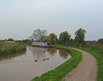
The Shropshire Union CanalShropshire Union Canal
The Shropshire Union Canal is a navigable canal in England; the Llangollen and Montgomery canals are the modern names of branches of the Shropshire Union system and lie partially in Wales....
south of the Hurleston Junction runs through the parish from the south east to the north west; the southern part is raised on the Nantwich Embankment. The River Weaver
River Weaver
The River Weaver is a river, navigable in its lower reaches, running in a curving route anti-clockwise across west Cheshire, northern England. Improvements to the river to make it navigable were authorised in 1720 and the work, which included eleven locks, was completed in 1732...
runs along the eastern boundary of the parish. The A51
A51 road
The A51 is a road in England running from Kingsbury in Warwickshire to Chester. The road follows the following route:*Kingsbury*Tamworth*Lichfield*Rugeley *Little Haywood*Great Haywood*Weston*Sandon...
runs east–west along the northern boundary of the parish, crossing the canal at Henhull Bridge. The Crewe and Nantwich Circular Walk
Crewe and Nantwich Circular Walk
The Crewe and Nantwich Circular Walk is a long-distance walkers' path in the Cheshire East area of Cheshire, England. As the name suggests, the walk forms a circuit around the towns of Crewe and Nantwich...
runs through the parish.
Notable features
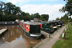
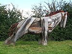
Nantwich Marina (at ) is at Basin End, the meeting point of the former Birmingham and Liverpool Junction Canal and Chester Canal, now both part of the Shropshire Union. Sculptures by the canal in this area form part of a community art project, including the 'Nantwich Horse', by John Merrill, constructed from recycled lock gates, hinges and bolts, which won a National Waterways Renaissance Award from the British Urban Regeneration Association in 2006.A police dog training school is located on Welshmen's Lane.