

Hammer projection
Encyclopedia
The Hammer projection is an equal-area map projection
, described by Ernst Hammer in 1892. Directly inspired by the Aitoff projection
, Hammer suggested the use of the equatorial form of the Lambert azimuthal equal-area projection
instead of Aitoff's use of the azimuthal equidistant projection
:


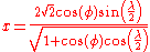
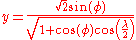
where and
and  are the x and y components of the equatorial Lambert azimuthal equal-area projection. Written out explicitly:
The inverse is calculated with the intermediate variable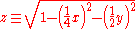
The longitude and latitudes can then be calculated by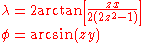
where is the longitude
from the central meridian and is the latitude
.
Visually, the Aitoff and Hammer projections are very similar. The Hammer has seen more use because of its equal-area property. The Mollweide projection
is another equal-area projection of similar aspect, though with straight parallels of latitude, unlike the Hammer's curved parallels.
Map projection
A map projection is any method of representing the surface of a sphere or other three-dimensional body on a plane. Map projections are necessary for creating maps. All map projections distort the surface in some fashion...
, described by Ernst Hammer in 1892. Directly inspired by the Aitoff projection
Aitoff projection
The Aitoff projection is a modified azimuthal map projection. Proposed by David A. Aitoff in 1889, it is the equatorial form of the azimuthal equidistant projection, but stretched into a 2:1 ellipse while halving the longitude from the central meridian:...
, Hammer suggested the use of the equatorial form of the Lambert azimuthal equal-area projection
Lambert azimuthal equal-area projection
The Lambert azimuthal equal-area projection is a particular mapping from a sphere to a disk . It accurately represents area in all regions of the sphere, but it does not accurately represent angles...
instead of Aitoff's use of the azimuthal equidistant projection
Azimuthal equidistant projection
The azimuthal equidistant projection is a type of map projection.A useful application for this type of projection is a polar projection in which all distances measured from the center of the map along any longitudinal line are accurate; an example of a polar azimuthal equidistant projection can be...
:
where
and are the x and y components of the equatorial Lambert azimuthal equal-area projection. Written out explicitly:The inverse is calculated with the intermediate variable
The longitude and latitudes can then be calculated by
where
is the longitudeLongitude
Longitude is a geographic coordinate that specifies the east-west position of a point on the Earth's surface. It is an angular measurement, usually expressed in degrees, minutes and seconds, and denoted by the Greek letter lambda ....
from the central meridian and
is the latitudeLatitude
In geography, the latitude of a location on the Earth is the angular distance of that location south or north of the Equator. The latitude is an angle, and is usually measured in degrees . The equator has a latitude of 0°, the North pole has a latitude of 90° north , and the South pole has a...
.
Visually, the Aitoff and Hammer projections are very similar. The Hammer has seen more use because of its equal-area property. The Mollweide projection
Mollweide projection
The Mollweide projection is a pseudocylindrical map projection generally used for global maps of the world . Also known as the Babinet projection, homalographic projection, homolographic projection, and elliptical projection...
is another equal-area projection of similar aspect, though with straight parallels of latitude, unlike the Hammer's curved parallels.