
Halawa, Hawaii
Encyclopedia
- Halawa may also refer to the food halvaHalvaHalva refers to many types of dense, sweet confections, served across the Middle East, South Asia, Central Asia, West Asia, North Africa, the Horn of Africa, the Balkans, Eastern Europe, Malta and the Jewish world.The term halva ,...
, or a famous valley and stream system (ahupua'aAhupua'aIn old Hawaii, ahupuaa was the common subdivision of the land. It is comparable to the tapere in the Southern Cook Islands. The traditional subdivision has four hierarchical levels:*mokupuni *moku...
) on the island of MolokaiMolokaiMolokai or Molokai is an island in the Hawaiian archipelago. It is 38 by 10 miles in size with a land area of , making it the fifth largest of the main Hawaiian Islands and the 27th largest island in the United States. It lies east of Oahu across the 25-mile wide Kaiwi Channel and north of...
.
Halawa is a census-designated place
Census-designated place
A census-designated place is a concentration of population identified by the United States Census Bureau for statistical purposes. CDPs are delineated for each decennial census as the statistical counterparts of incorporated places such as cities, towns and villages...
(CDP) in the ‘Ewa District of Honolulu County
Honolulu County, Hawaii
The City and County of Honolulu is a consolidated city–county located in the U.S. state of Hawaii. The municipality and county includes both the urban district of Honolulu and the rest of the island of Oahu, as well as several minor outlying islands, including all of the Northwestern Hawaiian...
, Hawaii
Hawaii
Hawaii is the newest of the 50 U.S. states , and is the only U.S. state made up entirely of islands. It is the northernmost island group in Polynesia, occupying most of an archipelago in the central Pacific Ocean, southwest of the continental United States, southeast of Japan, and northeast of...
, United States
United States
The United States of America is a federal constitutional republic comprising fifty states and a federal district...
. Halawa Stream branches into two valleys: North and South Halawa; North Halawa is the larger stream and fluvial feature. Their confluence is within the H-3/H-201 highways exchange. Most of Halawa Valley is undeveloped. As of the 2000 Census, the CDP had a total population of 13,891.
Cultural significance and H-3
The entire ahupuaʻa of Halawa is highly sacred to Kanaka Maoli. At the far Makai (ocean) side at Puʻuloa or Pearl HarborPearl Harbor
Pearl Harbor, known to Hawaiians as Puuloa, is a lagoon harbor on the island of Oahu, Hawaii, west of Honolulu. Much of the harbor and surrounding lands is a United States Navy deep-water naval base. It is also the headquarters of the U.S. Pacific Fleet...
, it is, according to Kanaka Maoli beliefs, the home of the shark goddess Kaʻahupahau, known as the "Queen of Sharks", who protected Oʻahu and strictly enforced kind, fair behavior on the part of both sharks and humans. Until the late 1890ʻs, the home of Kaʻahupahau was famously lined with beds of pearl oysters, however, according to Kanaka Maoli religious experts who follow the goddess, Kaʻahupahau removed all of the oysters (and some say, herself) because the area was being abused by human misdeeds. Today, the water of Pearl Harbor has been highly contaminated by nuclear defueling and other toxic influences, and has thereby been designated as a Superfund
Superfund
Superfund is the common name for the Comprehensive Environmental Response, Compensation, and Liability Act of 1980 , a United States federal law designed to clean up sites contaminated with hazardous substances...
site.
The upland, or Mauka, portion of Halawa is sacred to Papahanaumoku
Papahanaumoku
Papahanaumoku , or Pāpā, is the name of the Kanaka Maoli creator goddess in Hawaiian mythology. Together with her husband Wakea Pāpā is the ancestor of all people and Kalo, and mother of islands as the Kanaka Maoli manifestation of Mother Earth...
, the Kanaka Maoli form of Mother Earth
Mother Nature
Mother Nature is a common personification of nature that focuses on the life-giving and nurturing aspects of nature by embodying it in the form of the mother. Images of women representing mother earth, and mother nature, are timeless...
, as it is, according to legend, her birthplace and primary home, as well as one of only two or three known remaining Hale o Papa, womenʻs temples where Papa is worshipped. The valley contains many religious and other cultural sites sacred to Kanaka Maoli. Although many sites were destroyed by the invasion of Kahekili II
Kahekili II
Kahekili II, full name Kahekilinuiahumanu, was the twenty fifth King of Maui. His name was short for Kāne-Hekili after the Hawaiian god of thunder. Because Kāne-Hekili was believed to be black on one side, Kahekili tattooed one side of his body from head to foot.-Family:He was born about...
and especially by the building of the highly controversial H-3 Freeway
Interstate H-3
Interstate H-3 is an intrastate Interstate Highway located on the island of O'ahu in the state of Hawai'i in the United States. H-3 is also known as the John A. Burns Freeway...
, many remain and are cared for by Kanaka Maoli Aloha ʻAina practitioners to this day.
In the last two decades, North Halawa has been the site of a very public battle over the religious sites and ecological resources destroyed by H-3, which is the most expensive freeway per mile in human history. At least two species were driven to probable extinction (none have been sighted since construction began), many more are declining rapidly, the main aquifer of the area was badly damaged, and religious sites were seriously impacted. Although the freeway was opened in 1997, many are still fighting for mitigation of these impacts, and some are asking for the freewayʻs closure. In 1993, thirteen cultural practitioners
Cultural Practice
Cultural practice generally refers to the manifestation of a culture or sub-culture, especially in regard to the traditional and customary practices of a particular ethnic or other cultural group. In the broadest sense, this term can apply to any person manifesting any aspect of any culture at any...
were arrested while conducting a ceremony to pray for the healing of the valley. Their lele (religious altar) was destroyed, and the caretakers of the area were barred from entrance to the sites. Today, some of these caretakers, many of them kupuna (elders), have returned to care for the sites, although they now do so through a layer of soot and with the roar of the freeway as a constant sonic backdrop. Many kanaka maoli do not use the freeway because of these impacts, and because of the lasting belief that the road is haunted—an often-attributed explanation for the high accident rate on the freeway (more generally believed to be caused by the high speeds often used by the motorists who traverse it).
There is evidence in the documentary record that upper Halawa was highly significant to Kanaka Maoli. Most of the evidence may be, however, be in the oral record. The Hale O Papa and luakini are mentioned in the massive collection of Bishop Museum reports that took many years to finally be released. There was dispute between Barry Nakamura and one of the other archaeologists for Bishop Museum. Barry Nakamura was later fired from his position for "blowing the whistle" on Bishop Museums handling of iwi (human remains) that were removed from the valley. The Papa temples were associated with the great Ku temples (luakini), which demanded human sacrifice and were usually in areas of greater population and state sponsorship. Without a luakini, there would be no Hale o Papa, according to Samuel Kamakau(see Bishop Museum, H-3 project reports).
Neighborhoods
"Neighborhoods" of Halawa are very disjointed, in part because of the significant highway exchanges (see below) that now occupy nearly all of the lower end of Halawa Valley between Red Hill and Aloha StadiumAloha Stadium
Aloha Stadium is a stadium located in the Halawa CDP, City and County of Honolulu, Hawaii, United States. Currently Aloha Stadium is home to the University of Hawaii Warriors football team...
. Much of the remainder of the valley along both sides of Interstate H-3
Interstate H-3
Interstate H-3 is an intrastate Interstate Highway located on the island of O'ahu in the state of Hawai'i in the United States. H-3 is also known as the John A. Burns Freeway...
is developed into commercial and light industrial properties. On the east side of H-3 are found the State Animal Quarantine Station and the Halawa High and Medium Security Facility (main O‘ahu prison).
Where the valley widens out closer to Pearl Harbor
Pearl Harbor
Pearl Harbor, known to Hawaiians as Puuloa, is a lagoon harbor on the island of Oahu, Hawaii, west of Honolulu. Much of the harbor and surrounding lands is a United States Navy deep-water naval base. It is also the headquarters of the U.S. Pacific Fleet...
occur residential neighborhoods: Foster Village adjacent to Aliamanu; and the stadium area between Aloha Stadium and Makalapa. The interfluve (uplands between valleys) on the west comprises Halawa Heights, extending up to Camp H. M. Smith. Along the lower, western edge, Halawa Heights merges with the neighhborhoods of ‘Aiea.
The U.S. Postal Code for Halawa Heights is 96701 (the same as for Aiea). The postal code for Foster Village, the stadium area, and Makalapa is 96818 (the same as Aliamanu).
Geography
Halawa is located at 21°22′39"N 157°55′22"W (21.377633, -157.922759).According to the United States Census Bureau
United States Census Bureau
The United States Census Bureau is the government agency that is responsible for the United States Census. It also gathers other national demographic and economic data...
, the CDP has a total area of 2.3 square miles (6 km²), all land.
The route of Interstate H-3
Interstate H-3
Interstate H-3 is an intrastate Interstate Highway located on the island of O'ahu in the state of Hawai'i in the United States. H-3 is also known as the John A. Burns Freeway...
extends from its western terminus with east-west Moanalua Freeway
Interstate H-201
Interstate H-201 is an auxiliary Interstate Highway located on the island of O‘ahu in the U.S. state of Hawaii. The H-201 is also known as the Moanalua Freeway...
(H-201; connecting eastward to Honolulu
Honolulu, Hawaii
Honolulu is the capital and the most populous city of the U.S. state of Hawaii. Honolulu is the southernmost major U.S. city. Although the name "Honolulu" refers to the urban area on the southeastern shore of the island of Oahu, the city and county government are consolidated as the City and...
or westward to H-1
Interstate H-1
Interstate H-1 is the busiest Interstate Highway in Hawaii, United States, located on the island of O‘ahu. Despite the number, this is an east–west highway—the 'H'-series numbering reflects the order in which routes were funded and built. H-1 goes from Route 93 in Kapolei to Route 72 in...
and Aiea) to the 1100-foot (335-m) elevation entrance into the Tetsuo Harano Tunnels penetrating the Ko‘olau crest. The freeway continues beyond to Kaneohe on windward Oahu.
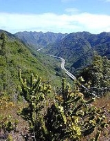
A significant proportion of Interstate H-3 within the valley is carried on a viaduct
Viaduct
A viaduct is a bridge composed of several small spans. The term viaduct is derived from the Latin via for road and ducere to lead something. However, the Ancient Romans did not use that term per se; it is a modern derivation from an analogy with aqueduct. Like the Roman aqueducts, many early...
(see photo at right). Although very expensive to construct, the viaduct is the only way to construct a freeway of this magnitude through such a narrow valley without flooding and destabilization concerns; it is also believed to offer some returns in terms of preservation of both archeological sites and stream ecology.
Demographics
As of the census of 2000, there were 13,891 people, 4,142 households, and 3,276 families residing in the CDP. The population densityPopulation density
Population density is a measurement of population per unit area or unit volume. It is frequently applied to living organisms, and particularly to humans...
was 5,974.5 inhabitants per square mile (2,301.9/km²). There were 4,289 housing units at an average density of 1,844.7 per square mile (710.7/km²). The racial makeup of the CDP was 15.50% White, 1.83% African American
African American
African Americans are citizens or residents of the United States who have at least partial ancestry from any of the native populations of Sub-Saharan Africa and are the direct descendants of enslaved Africans within the boundaries of the present United States...
, 0.20% Native American, 50.90% Asian, 10.43% Pacific Islander, 0.84% from other races, and 20.31% from two or more races. Hispanic or Latino
Latino
The demonyms Latino and Latina , are defined in English language dictionaries as:* "a person of Latin-American descent."* "A Latin American."* "A person of Hispanic, especially Latin-American, descent, often one living in the United States."...
of any race were 6.52% of the population.
There were 4,142 households out of which 30.3% had children under the age of 18 living with them, 60.1% were married couples
Marriage
Marriage is a social union or legal contract between people that creates kinship. It is an institution in which interpersonal relationships, usually intimate and sexual, are acknowledged in a variety of ways, depending on the culture or subculture in which it is found...
living together, 13.9% had a female householder with no husband present, and 20.9% were non-families. 15.5% of all households were made up of individuals and 5.2% had someone living alone who was 65 years of age or older. The average household size was 3.28 and the average family size was 3.64.
In the CDP the population was spread out with 23.4% under the age of 18, 9.9% from 18 to 24, 28.3% from 25 to 44, 22.6% from 45 to 64, and 15.8% who were 65 years of age or older. The median age was 37 years. For every 100 females there were 98.8 males. For every 100 females age 18 and over, there were 98.3 males.
The median income for a household in the CDP in 2000 was $63,176, and the median income for a family was $68,519. Males had a median income of $35,764 versus $28,527 for females. The per capita income
Per capita income
Per capita income or income per person is a measure of mean income within an economic aggregate, such as a country or city. It is calculated by taking a measure of all sources of income in the aggregate and dividing it by the total population...
for the CDP was $21,868. About 7.5% of families and 10.1% of the population were below the poverty line, including 20.9% of those under the age of 18 and 3.7% of those 65 and older.
Government and infrastructure
The Hawaii Department of Public SafetyHawaii Department of Public Safety
The Hawaii Department of Public Safety is a department with in the executive branch of the government of the U.S. state of Hawaii. It is headquartered in Room 400 in the 919 Ala Moana Boulevard building in Honolulu CDP, City and County of Honolulu...
operates the Halawa Correctional Facility
Halawa Correctional Facility
Halawa Correctional Facility is a prison in the City and County of Honolulu, Hawaii on the island of Oahu. It is operated by the Hawaii Department of Public Safety. The prison is in proximity to the communities of Aiea and Halawa....
in an area near Halawa.