

Hadejia-Nguru wetlands
Encyclopedia
The Hadejia-Nguru wetlands in Yobe State
in northern Nigeria
, which include Nguru Lake, are ecologically and economically important. They are threatened by reduced rainfall in recent years, a growing population and upstream dam construction.
s lie in the Yobe-Komadugu Basin. They are formed where the Hadejia
and Jama'are
rivers meet lines of ancient sand dunes in a northeast-southwest alignment and break into numerous channels. They are drained by the Yobe River
, which flows east towards Lake Chad
. They lie between Sudanian Savanna
to the south and the drier Sahel
to the north. Some of the land is permanently flooded, while other parts are flooded only in the wet season (August and September).
Annual rainfall ranges between 200–600 mm, during the period late May–September.
At one time the wetlands may have covered up to 3,000 km2. Between 1964 and 1971 over 2,000 km2 were flooded. By 1983 less than 900 km2 were flooded, and less than 300 km2 were flooded in the drought year of 1984.
 The Hadejia-Nguru wetlands are on the List of Ramsar wetlands of international importance. Nguru Lake
and the Marma Channel complex (58,100 ha) are designated a Ramsar Site. The wetlands are important for waterbirds, both for breeding species and for wintering and passage Palearctic
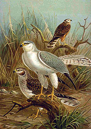
waterbirds. The estimated waterbird population varies between 200,000 and 325,000. 377 bird species have been seen in the wetlands, including occasional sightings of the near-threatened Pallid Harrier
and Great Snipe
species.
The Bade-Nguru Wetlands sector of the Chad Basin National Park
covers 938 km2 of the wetlands.
Parts of the wetlands are protected by five Forest Reserves
, a Wildlife Sanctuary
and a Ramsar Site
. With reduced flooding and increasing population, the environment is degrading and there is growing competition between humans and wildlife. Farmers set out poison to kill the crop-destroying Quelea quelea, in the process killing non-target species. Marginal land is now coming under cultivation and tree cover in the forest reserves is being depleted.
and fishermen
.
The wetlands support wet-season rice farming, flood-recession agriculture and dry-season farming using irrigation. Crops include peppers and wheat. The wetlands support fishermen, who often also farm, and provide fuel wood and leaves used for making mats and ropes. The lands are also grazed by Fulani cattle.
in recent years. Since the 1980s, the use of small gasoline-powered irrigation pumps has increased the land that can be used for farming, causing conflicts with the cattle herders and disputes over land ownership.
Dams have threatened the viability of the wetlands, particularly the Tiga Dam
and the Challawa Gorge Dam
, which now control most of the water flow in the Hadejia river and have reduced seasonal flooding and overall water supply. It is estimated that the Tiga dam on the Kano river has reduced flooding by about 350 km2.
A dam was built on the Hadejia river just upstream from the wetlands for irrigation purposes, completed in 1972, which has also affected flooding.
The proposed Kafin Zaki Dam
on the Jama'are river could pose a further threat.
Due to these changes, large areas of farming and grazing land and important fish ponds have either dried up along channels blocked by invasive Typha
grass, or have been flooded.
Yobe State
Yobe State is a state located in Northern Nigeria. A mainly agricultural state, it was created on August 27, 1991. Yobe state was carved out of present-day Borno State. The capital of Yobe state is Damaturu.-Geography:...
in northern Nigeria
Nigeria
Nigeria , officially the Federal Republic of Nigeria, is a federal constitutional republic comprising 36 states and its Federal Capital Territory, Abuja. The country is located in West Africa and shares land borders with the Republic of Benin in the west, Chad and Cameroon in the east, and Niger in...
, which include Nguru Lake, are ecologically and economically important. They are threatened by reduced rainfall in recent years, a growing population and upstream dam construction.
Geography
The wetlandWetland
A wetland is an area of land whose soil is saturated with water either permanently or seasonally. Wetlands are categorised by their characteristic vegetation, which is adapted to these unique soil conditions....
s lie in the Yobe-Komadugu Basin. They are formed where the Hadejia
Hadejia River
The Hadejia River is a river in northern Nigeria and is a tributary of the Yobe River .Among the cities and towns that lie on or near its banks are Hadejia and Nguru....
and Jama'are
Jama'are River
The Jama'are River, also known as the Bunga River in its upper reaches, starts in the highlands near Jos, Plateau State, Nigeria and flows northeast through Bauchi State and Yobe State before joining the Hadejia River to form the Yobe River...
rivers meet lines of ancient sand dunes in a northeast-southwest alignment and break into numerous channels. They are drained by the Yobe River
Yobe River
The Yobe River is a river in West Africa that flows into Lake Chad through Nigeria and Niger.Its tributaries include the Hadejia River and the Jama'are River...
, which flows east towards Lake Chad
Lake Chad
Lake Chad is a historically large, shallow, endorheic lake in Africa, whose size has varied over the centuries. According to the Global Resource Information Database of the United Nations Environment Programme, it shrank as much as 95% from about 1963 to 1998; yet it also states that "the 2007 ...
. They lie between Sudanian Savanna
Sudanian Savanna
The Sudanian Savanna is a broad belt of tropical savanna that runs east and west across the African continent, from the Atlantic Ocean in the west to the Ethiopian Highlands in the east. The Sahel, a belt of drier grasslands and acacia savannas, lies to the north, between the Sudanian Savanna and...
to the south and the drier Sahel
Sahel
The Sahel is the ecoclimatic and biogeographic zone of transition between the Sahara desert in the North and the Sudanian Savannas in the south.It stretches across the North African continent between the Atlantic Ocean and the Red Sea....
to the north. Some of the land is permanently flooded, while other parts are flooded only in the wet season (August and September).
Annual rainfall ranges between 200–600 mm, during the period late May–September.
At one time the wetlands may have covered up to 3,000 km2. Between 1964 and 1971 over 2,000 km2 were flooded. By 1983 less than 900 km2 were flooded, and less than 300 km2 were flooded in the drought year of 1984.
Ecology
Lake
A lake is a body of relatively still fresh or salt water of considerable size, localized in a basin, that is surrounded by land. Lakes are inland and not part of the ocean and therefore are distinct from lagoons, and are larger and deeper than ponds. Lakes can be contrasted with rivers or streams,...
and the Marma Channel complex (58,100 ha) are designated a Ramsar Site. The wetlands are important for waterbirds, both for breeding species and for wintering and passage Palearctic
Palearctic
The Palearctic or Palaearctic is one of the eight ecozones dividing the Earth's surface.Physically, the Palearctic is the largest ecozone...
waterbirds. The estimated waterbird population varies between 200,000 and 325,000. 377 bird species have been seen in the wetlands, including occasional sightings of the near-threatened Pallid Harrier
Pallid Harrier
The Pale or Pallid Harrier is a migratory bird of prey of the harrier family. It breeds in southern parts of eastern Europe and central Asia and winters mainly in India and southeast Asia...
and Great Snipe
Great Snipe
The Great Snipe, Gallinago media is a small stocky wader in the genus Gallinago.This bird's breeding habitat is marshes and wet meadows with short vegetation in north-eastern Europe including north-western Russia. Great Snipes are migratory, wintering in Africa...
species.
The Bade-Nguru Wetlands sector of the Chad Basin National Park
Chad Basin National Park
The Chad Basin National Park is a national park in northeastern Nigeria, with a total area of about 2,258 km².The park is fragmented, with three sectors.The Chingurmi-Duguma sector is in Borno State, in a Sudanian Savanna ecological zone....
covers 938 km2 of the wetlands.
Parts of the wetlands are protected by five Forest Reserves
Nature reserve
A nature reserve is a protected area of importance for wildlife, flora, fauna or features of geological or other special interest, which is reserved and managed for conservation and to provide special opportunities for study or research...
, a Wildlife Sanctuary
Wildlife refuge
A wildlife refuge, also called a wildlife sanctuary, may be a naturally occurring sanctuary, such as an island, that provides protection for species from hunting, predation or competition, or it may refer to a protected area, a geographic territory within which wildlife is protected...
and a Ramsar Site
Ramsar Convention
The Ramsar Convention is an international treaty for the conservation and sustainable utilization of wetlands, i.e., to stem the progressive encroachment on and loss of wetlands now and in the future, recognizing the fundamental ecological functions of wetlands and their economic, cultural,...
. With reduced flooding and increasing population, the environment is degrading and there is growing competition between humans and wildlife. Farmers set out poison to kill the crop-destroying Quelea quelea, in the process killing non-target species. Marginal land is now coming under cultivation and tree cover in the forest reserves is being depleted.
Economy
The area supports about 1.5 million farmers, herdersHerder
A herder is a worker who lives a possibly semi-nomadic life, caring for various domestic animals, in places where these animals wander pasture lands....
and fishermen
Fisherman
A fisherman or fisher is someone who captures fish and other animals from a body of water, or gathers shellfish. Worldwide, there are about 38 million commercial and subsistence fishermen and fish farmers. The term can also be applied to recreational fishermen and may be used to describe both men...
.
The wetlands support wet-season rice farming, flood-recession agriculture and dry-season farming using irrigation. Crops include peppers and wheat. The wetlands support fishermen, who often also farm, and provide fuel wood and leaves used for making mats and ropes. The lands are also grazed by Fulani cattle.
Issues
The wetlands have suffered from increasingly severe droughtsDrought
A drought is an extended period of months or years when a region notes a deficiency in its water supply. Generally, this occurs when a region receives consistently below average precipitation. It can have a substantial impact on the ecosystem and agriculture of the affected region...
in recent years. Since the 1980s, the use of small gasoline-powered irrigation pumps has increased the land that can be used for farming, causing conflicts with the cattle herders and disputes over land ownership.
Dams have threatened the viability of the wetlands, particularly the Tiga Dam
Tiga Dam
The Tiga Dam is in Kano State in the Northeast of Nigeria, constructed in 1971-1974. It is a major reservoir on the Kano River, the main tributary of the Hadejia River. Water from the dam supplies the Kano River Irrigation Project as well as Kano City...
and the Challawa Gorge Dam
Challawa Gorge Dam
The Challawa Gorge Dam is in Kano State in the Northeast of Nigeria, about 90 km southwest of Kano city. It is a major reservoir on the Challawa River, a tributary of the Kano River, which is the main tributary of the Hadejia River.-Construction:...
, which now control most of the water flow in the Hadejia river and have reduced seasonal flooding and overall water supply. It is estimated that the Tiga dam on the Kano river has reduced flooding by about 350 km2.
A dam was built on the Hadejia river just upstream from the wetlands for irrigation purposes, completed in 1972, which has also affected flooding.
The proposed Kafin Zaki Dam
Kafin Zaki Dam
The Kafin Zaki Dam is a controversial project to build a reservoir on the Jama'are River in Bauchi State in the Northeast of Nigeria.-Proposed dam and reservoir:...
on the Jama'are river could pose a further threat.
Due to these changes, large areas of farming and grazing land and important fish ponds have either dried up along channels blocked by invasive Typha
Typha
Typha is a genus of about eleven species of monocotyledonous flowering plants in the family Typhaceae. The genus has a largely Northern Hemisphere distribution, but is essentially cosmopolitan, being found in a variety of wetland habitats...
grass, or have been flooded.
External links
- G.E. Hollis, W.M. Adams & M. Aminu-Kano The Hadejia-Nguru Wetlands-Environment, Economy and Sustainable Development of a Sahelian Floodplain Wetland. 1993. (Contents page)