

Gürtel, Vienna
Encyclopedia
Vienna
Vienna is the capital and largest city of the Republic of Austria and one of the nine states of Austria. Vienna is Austria's primary city, with a population of about 1.723 million , and is by far the largest city in Austria, as well as its cultural, economic, and political centre...
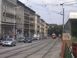
. Running 13.1 km (8.1 mi) parallel to the famous Ringstraße
Ringstraße
The Ringstraße is a circular road surrounding the Innere Stadt district of Vienna, Austria and is one of its main sights...
it encompasses the inner city
Inner city
The inner city is the central area of a major city or metropolis. In the United States, Canada, United Kingdom and Ireland, the term is often applied to the lower-income residential districts in the city centre and nearby areas...
districts (Innenbezirke).
The road is officially called B 221 Wiener Gürtel Straße. In the south it starts at the junction with the A23 Südosttangente motorway in the Landstraße
Landstraße
Landstraße is the 3rd municipal District of Vienna, Austria] . It is near the center of Vienna and was established in the 19th century. Landstraße is a heavily populated urban area with many workers and residential homes. It has inhabitants in an area of 7.42 km². It has existed since...
district and runs westward toward the Südbahnhof. Here the Wiedner Gürtel and Margaretengürtel mark the border of Wieden
Wieden
Wieden is the 4th municipal District of Vienna, Austria . It is near the center of Vienna and was established as a district in 1850, but borders changed later...
and Margareten
Margareten
Margareten is the fifth district of Vienna . It is near the center of Vienna and was established as a district in 1850, but borders changed later. Margareten is a heavily populated urban area with many workers and residential homes.- Description :...
with the southern Favoriten
Favoriten
Favoriten, the 10th district of Vienna, Austria , is located south of the central districts. It is south of Innere Stadt, Wieden and Margareten...
suburb. The Gürtel then turns north, running along the eastern rim of the Meidling
Meidling
Meidling is the 12th district of Vienna . It is located just southwest of the central districts, south of the Wienfluss, west of the Gürtel belt, and east and southeast of Schönbrunn palace...
suburb, crossing the Wienfluss and the Wienzeile
Wienzeile
The Wienzeile is a street in Vienna, which originated in the course of the regulation of the Vienna River between 1899 and 1905 along the river's banks....
road, separating the inner city districts of Mariahilf
Mariahilf
Mariahilf is the 6th municipal district of Vienna, Austria . It is near the center of Vienna and was established as a district in 1850. Mariahilf is a heavily populated urban area with many residential buildings....
and Neubau
Neubau
Neubau is the seventh district of Vienna . It is located near the center of Vienna and was established as a district in 1850, but borders changed later...
in the east from Rudolfsheim-Fünfhaus
Rudolfsheim-Fünfhaus
Rudolfsheim-Fünfhaus is the 15th municipal District of Vienna, Austria . It is in central Vienna, west of Innere Stadt....
with the Westbahnhof. The road continues as the border of Josefstadt
Josefstadt
Josefstadt is the eighth district of Vienna . It is near the center of Vienna and was established as a district in 1850, but borders changed later. Josefstadt is a heavily populated urban area with many workers and residential homes.It has a population of 22,057 people...
and Alsergrund
Alsergrund
Alsergrund is the ninth district of Vienna, Austria . It is located just north of the first, central district, Innere Stadt. Alsergrund was incorporated in 1862, with seven suburbs. The area is densely populated, with a lot of government-built housing. According to the census of 2001, there were...
with the outer Hernals
Hernals
Hernals is the 17th district of Vienna, Austria .Hernals is in northwest Vienna.It was annexed in 1892 out of the townships of Hernals, Dornbach, and Neuwaldegg.- Geography :...
and Währing
Währing
Währing is the 18th district of Vienna, Austria. It is in the northwest part of the city. In addition to currently hosting a number of Vienna's foreign embassies, Währing was the site of the original burial places of composers Ludwig van Beethoven and Franz Schubert.-Location:Währing lies in the...
districts, passing the General Hospital
Vienna General Hospital
The Vienna General Hospital is the University medical center of the city of Vienna, Austria. The AKH is the largest hospital of Austria and Europe, the second largest hospital in the world, and at 85-m high is one of the tallest hospital buildings in the world...
(Allgemeines Krankenhaus, AKH) and the Volksoper
Vienna Volksoper
The Vienna Volksoper is a major opera house in Vienna, Austria. It gives about three hundred performances of twenty-five productions during an annual season running from September through June....
. At its northern end in Döbling
Döbling
Döbling is the 19th District in the city of Vienna, Austria . It is located on the north end from the central districts, north of the districts Alsergrund and Währing...
, the Gürtel reaches the Donaukanal
Donaukanal
The Donaukanal is a former arm of the river Danube, now regulated as a water channel , within the city of Vienna, Austria...
at the Gürtelbrücke. From the Wienzeile to the northern end, the dual carriageway is accompanied by the historic Stadtbahn
Wiener Stadtbahn
The Wiener Stadtbahn was a public transportation system operated under this name from 1898 to 1989. Today, the Vienna U-Bahn lines U4 and U6 and the Vienna S-Bahn run on its former lines....
viaduct designed by Otto Wagner
Otto Wagner
Otto Koloman Wagner was an Austrian architect and urban planner, known for his lasting impact on the appearance of his home town Vienna, to which he contributed many landmarks.-Life:...
, today operated by the U6 U-Bahn
Vienna U-Bahn
The Vienna U-Bahn is a rapid transit system consisting of five lines. It is the backbone of one of the best performing public transport systems worldwide according to UITP in June 2009. More than 1.3 million passengers use the Vienna U-Bahn every day...
line.
The Gürtel was laid out from 1873 at the site of the former Linienwall fortification, built under Emperor Leopold I of Habsburg
Leopold I, Holy Roman Emperor
| style="float:right;" | Leopold I was a Holy Roman Emperor, King of Hungary and King of Bohemia. A member of the Habsburg family, he was the second son of Emperor Ferdinand III and his first wife, Maria Anna of Spain. His maternal grandparents were Philip III of Spain and Margaret of Austria...
at the beginning of the 18th century to protect his residence from kuruc
Kuruc
The kuruc was a term used to denote the armed anti-Habsburg rebels in Royal Hungary between 1671 and 1711....
invasions in the course of Rákóczi's War for Independence
Rákóczi's War for Independence
Rákóczi's War for Independence was the first significant attempt to topple therule of Habsburg Austria over Hungary. The war was fought by a group of noblemen, wealthy and high-ranking progressives and was led by Francis II Rákóczi Rákóczi's War for Independence (1703–1711) was the first...
. After World War I
World War I
World War I , which was predominantly called the World War or the Great War from its occurrence until 1939, and the First World War or World War I thereafter, was a major war centred in Europe that began on 28 July 1914 and lasted until 11 November 1918...
the road became the construction site for several public housing
Public housing
Public housing is a form of housing tenure in which the property is owned by a government authority, which may be central or local. Social housing is an umbrella term referring to rental housing which may be owned and managed by the state, by non-profit organizations, or by a combination of the...
estates (Gemeindebau
Gemeindebau
Gemeindebau is a German word for "municipality building". It refers to residential buildings erected by a municipality, usually to provide low-cost public housing....
ten) in the era of Red Vienna
Red Vienna
Red Vienna was the nickname of the capital of Austria between 1918 and 1934, when the Social Democrats had the majority and the city was democratically governed for the first time.-Social situation after World War I:...
. As in the most parts of Austria–Hungary vehicles formerly moved on the left, like in Britain, until after the Anschluss
Anschluss
The Anschluss , also known as the ', was the occupation and annexation of Austria into Nazi Germany in 1938....
in 1938 according to German regulations traffic in Vienna was redirected to pass on the right as elsewhere on the Continent. Plans developed in the 1960s and 70s to rebuilt the Gürtel as a city motorway have never been carried out. The road like the adjacent residential areas are however strongly affected by the high traffic volume.
Further reading
- Madeleine PetrovicMadeleine PetrovicMadeleine Petrovic is an Austrian politician. From 1994 to 1996 she was federal spokesperson of the Austrian Green Party....
: Der Wiener Gürtel. Wiederentdeckung einer lebendigen Prachtstraße (Verlag Christian Brandstätter: Wien, 1998) (ISBN 3854477236).