

Gurbantunggut Desert
Encyclopedia
Dzungaria
Dzungaria, also called Zungaria, is a geographical region in northwest China corresponding to the northern half of Xinjiang. It covers approximately , lying mostly within Xinjiang, and extending into western Mongolia and eastern Kazakhstan...
n Basin in northern Xinjiang
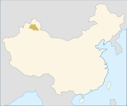
Xinjiang
Xinjiang is an autonomous region of the People's Republic of China. It is the largest Chinese administrative division and spans over 1.6 million km2...
, in the northwest of the People's Republic of China
People's Republic of China
China , officially the People's Republic of China , is the most populous country in the world, with over 1.3 billion citizens. Located in East Asia, the country covers approximately 9.6 million square kilometres...
. It is approximately 50,000 square kilometers (19,000 mi²), and located around 300 to 600 meters above sea level. It is China's (and Xinjiang's) second largest desert, after Taklamakan Desert, which is located in the Tarim Basin
Tarim Basin
The Tarim Basin is a large endorheic basin occupying an area of about . It is located in the Xinjiang Uyghur Autonomous Region in China's far west. Its northern boundary is the Tian Shan mountain range and its southern is the Kunlun Mountains on the northern edge of the Tibetan Plateau. The...
.
A remote, arid, and rugged area, Gurbantünggüt Desert is separated by the Tian Shan
Tian Shan
The Tian Shan , also spelled Tien Shan, is a large mountain system located in Central Asia. The highest peak in the Tian Shan is Victory Peak , ....
mountains from the Ili River
Ili River
thumb|right|300px|Map of the Lake Balkhash drainage basin showing the Ili River and its tributariesThe Ili River is a river in northwestern China and southeastern Kazakhstan .It is long, of which is in Kazakhstan...
Basin, Turfan Depression
Turfan Depression
The Turpan Depression or Turfan Depression is a fault-bounded trough located around and south of the city-oasis of Turpan, in the Xinjiang Autonomous Region in far western China, about 150 km southeast of the provincial capital Ürümqi. It includes the third lowest exposed point on the Earth's...
, and the Tarim Basin
Tarim Basin
The Tarim Basin is a large endorheic basin occupying an area of about . It is located in the Xinjiang Uyghur Autonomous Region in China's far west. Its northern boundary is the Tian Shan mountain range and its southern is the Kunlun Mountains on the northern edge of the Tibetan Plateau. The...
of the southern Xinjiang
Xinjiang
Xinjiang is an autonomous region of the People's Republic of China. It is the largest Chinese administrative division and spans over 1.6 million km2...
. A chain of cities, the largest of which is Ürümqi
Ürümqi
Ürümqi , formerly Tihwa , is the capital of Xinjiang Uyghur Autonomous Region of the People's Republic of China, in the northwest of the country....
, are located within a populated strip (the route of the Lanxin Railway
Lanxin railway
The Lanzhou−Xinjiang Railway or Lanxin Railway is the longest railway in northwestern China. It runs from Lanzhou, Gansu, through the Hexi Corridor, to Ürümqi, in the Xinjiang. It is Xinjiang's only rail link with the rest of China...
) south of the desert, which is irrigated by glacier-fed streams flowing from the Tian Shan.
China National Highway 216
China National Highway 216
China National Highway 216 is a Highway in Xinjiang, China. It runs in the general southern direction from Altay City, Xinjiang to Baluntai , where it joins China National Highway 218. It is 857 kilometres in length....
crosses the desert in the north-south direction, from Altay City to Ürümqi
Ürümqi
Ürümqi , formerly Tihwa , is the capital of Xinjiang Uyghur Autonomous Region of the People's Republic of China, in the northwest of the country....
.
The climate of the area is temperate, but very continental. The desert's eco-environment is very fragile, and the impact of human activities on the eco-environment, including the building of a trans-desert highway, has been increasingly significant.
It is in this desert
Desert
A desert is a landscape or region that receives an extremely low amount of precipitation, less than enough to support growth of most plants. Most deserts have an average annual precipitation of less than...
that the remotest point of land
Pole of inaccessibility
A pole of inaccessibility marks a location that is the most challenging to reach owing to its remoteness from geographical features that could provide access...
from any sea is located. The precise point is at 46°16.8′N 86°40.2′E. It was pin-pointed and reached on 27 June 1986 by British explorers Nicholas Crane
Nicholas Crane
Nicholas Crane is an English geographer, explorer, writer and broadcaster. Since 2004, he has written and presented four notable television series for BBC Two: Coast, Great British Journeys, Map Man and Town....
and Dr Richard Crane; the location, for whatever reason (possibly, a Mongolian name) was described as the Dzoosotoyn Elisen Desert. This position is over 2,600 kilometers (1,600 mi) from the nearest coastline.