

Grossglockner High Alpine Road
Encyclopedia
The Grossglockner High Alpine Road (in German Großglockner-Hochalpenstraße) is a panoramic road in Austria
, in the state of Salzburg
. It connects the state of Salzburg with the state of Carinthia
. It is named after the Großglockner
, Austria's highest mountain.
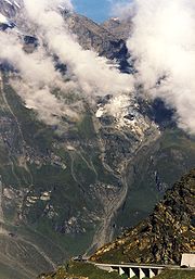
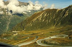
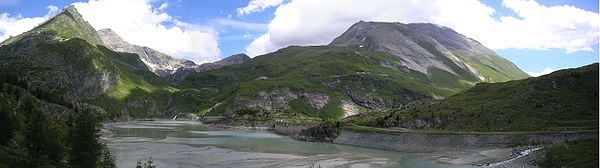
It leads with numbered hairpin curves to the Kaiser Franz Josefs Höhe Visitors' Centre, with a panoramic view of the Pasterze Glacier
and the Großglockner itself. The road is a toll road
, with toll booths at Ferleiten in the direction of Salzburg
. Motorists arriving from the south from Carinthia
come through Heiligenblut
.
 When, in 1924, a group of Austrian experts presented a plan for a road over the Hochtor (the high pass), they were ridiculed in a time when in Austria
, Germany
, and Italy
there were only 154,000 private automobiles, 92,000 motorcycles, and 2000 kilometres (1,242.7 mi) of long-distance asphalt roads. Austria had suffered from the catastrophic economic results of losing the First World War, had shrunk to a seventh of its imperial size, lost its international markets and suffered devastating inflation.
Even the modest design of a 3 metres (9.8 ft) gravel road, with overtaking points, appeared too expensive. The impulse for building a road, which was meant to open up the barren alpine valleys to motorized tourism, was given by the New York
stock market slump in 1929. This catastrophe shook an impoverished Austria with terrible force.
Within three years, the economic output dropped by a quarter, and unemployment rate reached 26%. The government then revived the Grossglockner project to give work to 3,200 (from an average of 520,000 jobless). The project was extended to a width of 6 metres (19.7 ft) to serve the needs of the "excessive international traffic" - which was roundly mocked - in the belief that an annual 120,000 visitors would come. The State advanced the building costs, and the users were to pay off this sum with a toll fee for usage.
On 30 August 1930 at 9:30am, the first explosives roared in Ferleiten. Four years later, the moving force of the road building, the Salzburg
provincial head of government Franz Rehrl, and the technician Franz Wallack
climbed into their Steyr 100
car, and achieved the first alpine crossing in an automobile on a graded road.
A year later, on 3 August 1935, the Grossglockner High Alpine Road was opened and put into full service a day later with an international automobile and motorcycle race
.
Including the building of the access roads, the Glockner Road cost Austrian Schilling
910 million (at 1990 rates), around seven million less than estimated.
Planners had reckoned with 120,000 visitors in 1930, but the road's attraction for tourists in 1938 brought 375,000 visitors in 98,000 vehicles. After the Second World War it took until 1952 before the pre-war record was surpassed with 412,000 visitors and 91,000 vehicles. In 1962, 360,000 vehicles and 1.3 million visitors crossed the pass.
 The opening of the Felbertauern Road (1967) and the Tauern Motorway (1975) throttled traffic by nearly 15 per cent, but it also permanently changed the character of the Großglockner High Alpine Road: from the only transalpine road over the 158 kilometres (98.2 mi) main alpine crest between the Brenner Pass
and the Katschberg Pass
, to an excursion road from a catchment area with a radius of around 130 kilometres (80.8 mi).
The Glockner Road also reflects the material advance of the people: in the early years, the motorcycle - as the poor man's car - accounted for up to a quarter of the traffic; 1955 was the highpoint with 47,500 motorcycles (26% of the traffic); in 1968, only 2,071 motorcycles were to be counted. The number of motorcycles on the Grossglockner High Alpine Road then rose by 2003 to over 76,000.
Increasing numbers of visitors made the stage-by-stage modernization of the road necessary after 1953 to a width of 7.5 metres (24.6 ft), to 15 metres (49.2 ft) in place of 10 metres (32.8 ft) bend radius, and 4,000 parking places instead of 800 and an annual capacity of up to 350,000 vehicles.
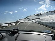
In 1937, the road could only be traversed for 132 days, but in 1963 the road could be traversed for 276 days. The Grossglockner High Alpine Road is normally open from the beginning of May to the end of October.
until 15 June: 6am - 8pm
16 June until 15 September: 5am - 9.30pm
16 September until end of October: 6am - 7.30pm
Last admission: 45 min. before night closure
Austria
Austria , officially the Republic of Austria , is a landlocked country of roughly 8.4 million people in Central Europe. It is bordered by the Czech Republic and Germany to the north, Slovakia and Hungary to the east, Slovenia and Italy to the south, and Switzerland and Liechtenstein to the...
, in the state of Salzburg
Salzburg (state)
Salzburg is a state or Land of Austria with an area of 7,156 km2, located adjacent to the German border. It is also known as Salzburgerland, to distinguish it from its capital city, also named Salzburg...
. It connects the state of Salzburg with the state of Carinthia
Carinthia (state)
Carinthia is the southernmost Austrian state or Land. Situated within the Eastern Alps it is chiefly noted for its mountains and lakes.The main language is German. Its regional dialects belong to the Southern Austro-Bavarian group...
. It is named after the Großglockner
Großglockner
The Grossglockner is, at 3,798 m above sea level, Austria's highest mountain and the highest mountain in the Alps east of the Brenner Pass...
, Austria's highest mountain.
It leads with numbered hairpin curves to the Kaiser Franz Josefs Höhe Visitors' Centre, with a panoramic view of the Pasterze Glacier
Pasterze Glacier
The Pasterze, at approximately 8.4 kilometers in length, is the longest glacier in Austria and in the Eastern Alps reaching from the Johannisberg to above sea level. It lies within the Hohe Tauern mountain range in Carinthia, directly beneath Austria's highest mountain, the Grossglockner...
and the Großglockner itself. The road is a toll road
Toll road
A toll road is a privately or publicly built road for which a driver pays a toll for use. Structures for which tolls are charged include toll bridges and toll tunnels. Non-toll roads are financed using other sources of revenue, most typically fuel tax or general tax funds...
, with toll booths at Ferleiten in the direction of Salzburg
Salzburg
-Population development:In 1935, the population significantly increased when Salzburg absorbed adjacent municipalities. After World War II, numerous refugees found a new home in the city. New residential space was created for American soldiers of the postwar Occupation, and could be used for...
. Motorists arriving from the south from Carinthia
Carinthia (state)
Carinthia is the southernmost Austrian state or Land. Situated within the Eastern Alps it is chiefly noted for its mountains and lakes.The main language is German. Its regional dialects belong to the Southern Austro-Bavarian group...
come through Heiligenblut
Heiligenblut
Heiligenblut is a municipality in the district of Spittal an der Drau in the Austrian state of Carinthia. Situated in the high-Alpine region of the Hohe Tauern mountain range at 1,288 meters, Heiligenblut is located at the foot of the Großglockner, the highest mountain in Austria, and the Pasterze...
.
History
Austria
Austria , officially the Republic of Austria , is a landlocked country of roughly 8.4 million people in Central Europe. It is bordered by the Czech Republic and Germany to the north, Slovakia and Hungary to the east, Slovenia and Italy to the south, and Switzerland and Liechtenstein to the...
, Germany
Germany
Germany , officially the Federal Republic of Germany , is a federal parliamentary republic in Europe. The country consists of 16 states while the capital and largest city is Berlin. Germany covers an area of 357,021 km2 and has a largely temperate seasonal climate...
, and Italy
Italy
Italy , officially the Italian Republic languages]] under the European Charter for Regional or Minority Languages. In each of these, Italy's official name is as follows:;;;;;;;;), is a unitary parliamentary republic in South-Central Europe. To the north it borders France, Switzerland, Austria and...
there were only 154,000 private automobiles, 92,000 motorcycles, and 2000 kilometres (1,242.7 mi) of long-distance asphalt roads. Austria had suffered from the catastrophic economic results of losing the First World War, had shrunk to a seventh of its imperial size, lost its international markets and suffered devastating inflation.
Even the modest design of a 3 metres (9.8 ft) gravel road, with overtaking points, appeared too expensive. The impulse for building a road, which was meant to open up the barren alpine valleys to motorized tourism, was given by the New York
New York
New York is a state in the Northeastern region of the United States. It is the nation's third most populous state. New York is bordered by New Jersey and Pennsylvania to the south, and by Connecticut, Massachusetts and Vermont to the east...
stock market slump in 1929. This catastrophe shook an impoverished Austria with terrible force.
Within three years, the economic output dropped by a quarter, and unemployment rate reached 26%. The government then revived the Grossglockner project to give work to 3,200 (from an average of 520,000 jobless). The project was extended to a width of 6 metres (19.7 ft) to serve the needs of the "excessive international traffic" - which was roundly mocked - in the belief that an annual 120,000 visitors would come. The State advanced the building costs, and the users were to pay off this sum with a toll fee for usage.
On 30 August 1930 at 9:30am, the first explosives roared in Ferleiten. Four years later, the moving force of the road building, the Salzburg
Salzburg
-Population development:In 1935, the population significantly increased when Salzburg absorbed adjacent municipalities. After World War II, numerous refugees found a new home in the city. New residential space was created for American soldiers of the postwar Occupation, and could be used for...
provincial head of government Franz Rehrl, and the technician Franz Wallack
Franz Wallack
Hofrat Dipl.-Ing. Franz Friedrich Wallack was the planning engineer of the Grossglockner High Alpine Road in Austria....
climbed into their Steyr 100
Steyr 100
The Steyr 100 and 200 were a series of medium-sized cars built by the Austrian firm Steyr-Puch from 1934 to 1940.The cars had a 4-cylinder engine driving the rear wheels and the streamlined body, designed by Karl Jenschke, was manufactured by Gläser in Dresden.In 1936 the vehicle underwent...
car, and achieved the first alpine crossing in an automobile on a graded road.
A year later, on 3 August 1935, the Grossglockner High Alpine Road was opened and put into full service a day later with an international automobile and motorcycle race
Grossglockner Races
The Grossglockner Automobile and Motorcycle Races took place in 1935, 1938 and 1939 on the Grossglockner High Alpine Road in Austria, county Salzburg.-History:...
.
Including the building of the access roads, the Glockner Road cost Austrian Schilling
Austrian schilling
The schilling was the currency of Austria from 1924 to 1938 and from 1945 to 1999, and the circulating currency until 2002. The euro was introduced at a fixed parity of €1 = 13.7603 schilling to replace it...
910 million (at 1990 rates), around seven million less than estimated.
Planners had reckoned with 120,000 visitors in 1930, but the road's attraction for tourists in 1938 brought 375,000 visitors in 98,000 vehicles. After the Second World War it took until 1952 before the pre-war record was surpassed with 412,000 visitors and 91,000 vehicles. In 1962, 360,000 vehicles and 1.3 million visitors crossed the pass.
Brenner Pass
- Roadways :The motorway E45 leading from Innsbruck via Bolzano to Verona and Modena uses this pass, and is one of the most important north-south connections in Europe...
and the Katschberg Pass
Katschberg Pass
Katschberg Pass is a high mountain pass in the Central Eastern Alps in Austria between Rennweg am Katschberg in the state of Carinthia and Sankt Michael im Lungau in Salzburg....
, to an excursion road from a catchment area with a radius of around 130 kilometres (80.8 mi).
The Glockner Road also reflects the material advance of the people: in the early years, the motorcycle - as the poor man's car - accounted for up to a quarter of the traffic; 1955 was the highpoint with 47,500 motorcycles (26% of the traffic); in 1968, only 2,071 motorcycles were to be counted. The number of motorcycles on the Grossglockner High Alpine Road then rose by 2003 to over 76,000.
Increasing numbers of visitors made the stage-by-stage modernization of the road necessary after 1953 to a width of 7.5 metres (24.6 ft), to 15 metres (49.2 ft) in place of 10 metres (32.8 ft) bend radius, and 4,000 parking places instead of 800 and an annual capacity of up to 350,000 vehicles.
Snow clearing
In the years 1936 and 1937, 350 men shovelled 250000 cubic metres (8,828,666.6 cu ft) of snow in an average of seventy days to keep at least one lane on the road free. Since 1953, the five Wallack rotary plows, and twelve GROHAG workers, have been clearing 600000 to 800000 m³ (21,188,799.7 to 28,251,733 ) of snow from the road and parking areas in around fourteen days every year in April.In 1937, the road could only be traversed for 132 days, but in 1963 the road could be traversed for 276 days. The Grossglockner High Alpine Road is normally open from the beginning of May to the end of October.
Opening Times
Usually the road opens in first days of Mayuntil 15 June: 6am - 8pm
16 June until 15 September: 5am - 9.30pm
16 September until end of October: 6am - 7.30pm
Last admission: 45 min. before night closure
See also
- List of highest paved roads in Europe
- List of mountain passes