
Großglockner
Encyclopedia
The Grossglockner is, at 3,798 m above sea level, Austria
's highest mountain
and the highest mountain in the Alps
east of the Brenner Pass
. This makes it, after Mont Blanc
, the second most prominent mountain in the Alps, when measured by relative height
; see the list of Alpine peaks by prominence.
The Grossglockner lies on the border between Carinthia
and the East Tyrol
; it is the highest peak in the Glockner group, a group of mountains along the main ridge of the Hohe Tauern
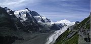
. The summit itself lies on the Glockner ridge, which branches to the south off the main ridge. The Pasterze
, Austria's biggest glacier
, lies at the Grossglockner's foot.
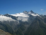
The characteristically pyramid
-shaped peak actually consists of two pinnacles, the Großglockner and the Kleinglockner (3,770 m; klein means "small" in German), separated by a saddle-like formation known as the Glocknerscharte.
in the Glockner Group (Austrian Central Alps) that branches off the main chain of the Alps
at the Eiskögele heading in a southeasterly direction and forming the boundary between the Austrian federal states of Tyrol (municipality of Kals am Großglockner
) in the southwest and Carinthia
(municipality of Heiligenblut) in the northeast. This boundary is also the watershed between the Kalser Tal and its side valley
s, the Teischnitz and the Ködnitz
valleys on the Tyrolean side and the Möll
valley with its glacier, the Pasterze, on the Carinthian side. In addition, the region around the mountain has formed part of the Großglockner-Pasterze Special Protection Area within the High Tauern National Park since 1986.
The Glockner is the highest mountain in the Alps east of the Ortler Alps
,175 km away, and, after Mont Blanc
, has the second greatest topographic isolation
of all mountains in the Alps. Even its topographic prominence
, at 2,424 metres, is the second highest after Mont Blanc in the entire Alps. That makes it one of the most independent peaks in the Alps. The view from the Großglockner is one of the farthest of all the mountains in the Eastern Alps. It ranges out to 220 kilometres or, taking account of atmospheric refraction
, almost 240 kilometres. Its view over more than 150,000 square kilometres of the earth's surface reaches as far as the Schwabian-Bavarian Plain in the northwest, to Regensburg
and the Bohemian Forest
in the north, to the Ortler
in the west, to Poebene in the south, and to Triglav
and the Totes Gebirge
in the east. The most important places in the local area are Kals am Großglockner
, about 8 kilometres southwest in the Kalser Tal valley, and Heiligenblut , ca. twelve kilometres southeast in the Möll
valley.
to the southeast it forms a striking double peak. There are differing views in the literature as to whether the Kleinglockner is a subpeak or independent main summit. Due to its low topographic prominence and isolation as well as its close links, its climbing history is counted as part of that of the Großglockner in historic publications; but due to its separate routes it is counted in climbing literature as an independent peak. Between the two peaks lies the Obere Glocknerscharte which, at , is the highest col
in Austria, from which a couloir
up to 55° in gradient and 600 metres high descends to the Glocknerkees glacier, called the Pallavicinirinne after the climber, Alfred von Pallavicini. The couloir runs northeast and borders on the Northeast and North Faces of the Großglockner. The latter faces are bounded by the Northwest Ridge, part of the main Glockner crest, which runs over the Grögerschneid and the ridge elevations of the Glocknerhorn and Teufelshorn
to the Untere Glocknerscharte , which connects to the high Glocknerwand
. A prominent ridge, the Stüdlgrat (named after Johann Stüdl), runs from the Großglockner away to the southwest, which together with its extension, the Luisengrat, separates the West Face and the glacier at its foot, the Teischnitzkees, from the South Face and its glacier, the Ködnitzkees. A couloir known as the Pillwaxrinne crosses the South Face below the Obere Glocknerscharte; most of the South Face lies east of this gully below the Kleinglockner. The east side of the Kleinglockner, the Glocknerleitl, is glaciated to just below the summit and is continued by the Kleinglocknerkees and Hofmannskees before reaching the Pasterze.
Inspired by the book the local bishop, cardinal Franz Xaxer Salm-Reifferscheid, started efforts for an expedition and engaged two carpenters of Heiligenblut, Martin and Sepp Klotz, to do the first explorations for an ascent through the Leitertal valley, which is the side of Grossglockner with the least ice (people feared glaciers in these times). The two brothers did more than they were ordered to do - and probably reached the summit of the Kleinglockner on July 23, 1799.
One month later the expedition of the cardinal started: a hut (the first Salm hut) was built and the path in the Leitertal valley was prepared so that the cardinal could use a horse to reach the hut. 30 people were part of the expedition. They suffered with bad weather. A first effort failed, but on August 25, 1799 the brothers Klotz and at least 4 other people reached - again the Kleinglockner. There they installed a cross (one of the main goals of the church expedition). The reports did not tell clearly that they had not touched the highest point but the cardinal (who had reached the Adlersruhe) was informed. He was not satisfied and invented another, even bigger expedition the next year.
On July 27, 1800, 62 (!) people started again into the Leitertal valley.
On July 28 the climb started. 4 carpenters (the brothers Klotz and two others who are not known) did a track in the snow and installed fixed ropes at some steeper sections up to the end of the Glocknerleitl. But only these four and P. Horasch, the local priest of the village Doellach, were able to cross the Obere Glocknerscharte and climb Grossglockner summit.
The next day the carpenters and some others (among them Valentin Stanič, who climbed some weeks later Watzmann for the first time) did the climb again and installed the summit cross
, now on the real summit.
The first winter ascent of the Grossglockner was made on January 2, 1875 by William Adolf Baillie Grohman
, a member of the Alpine Club
.
(Großglockner-Hochalpenstraße) between Heiligenblut
and Bruck
was built between 1930 and 1935 according to plans of the engineer Franz Wallack
and reaches a height of 2572 m (8438 ft). It is one of the main tourist attractions in Austria and has over 1.2 million visitors every year; however, it is closed in the winter.
, won by Pierfranco Vianelli
.
Grossglockner was featured for a second time in 13th stage of the 2011 Giro d'Italia
. It was José Rujano
who arrived first, after an escape with Alberto Contador
.
Computer-generated virtual panoramas
Austria
Austria , officially the Republic of Austria , is a landlocked country of roughly 8.4 million people in Central Europe. It is bordered by the Czech Republic and Germany to the north, Slovakia and Hungary to the east, Slovenia and Italy to the south, and Switzerland and Liechtenstein to the...
's highest mountain
Mountain
Image:Himalaya_annotated.jpg|thumb|right|The Himalayan mountain range with Mount Everestrect 58 14 160 49 Chomo Lonzorect 200 28 335 52 Makalurect 378 24 566 45 Mount Everestrect 188 581 920 656 Tibetan Plateaurect 250 406 340 427 Rong River...
and the highest mountain in the Alps
Alps
The Alps is one of the great mountain range systems of Europe, stretching from Austria and Slovenia in the east through Italy, Switzerland, Liechtenstein and Germany to France in the west....
east of the Brenner Pass
Brenner Pass
- Roadways :The motorway E45 leading from Innsbruck via Bolzano to Verona and Modena uses this pass, and is one of the most important north-south connections in Europe...
. This makes it, after Mont Blanc
Mont Blanc
Mont Blanc or Monte Bianco , meaning "White Mountain", is the highest mountain in the Alps, Western Europe and the European Union. It rises above sea level and is ranked 11th in the world in topographic prominence...
, the second most prominent mountain in the Alps, when measured by relative height
Topographic prominence
In topography, prominence, also known as autonomous height, relative height, shoulder drop , or prime factor , categorizes the height of the mountain's or hill's summit by the elevation between it and the lowest contour line encircling it and no higher summit...
; see the list of Alpine peaks by prominence.
The Grossglockner lies on the border between Carinthia
Carinthia (state)
Carinthia is the southernmost Austrian state or Land. Situated within the Eastern Alps it is chiefly noted for its mountains and lakes.The main language is German. Its regional dialects belong to the Southern Austro-Bavarian group...
and the East Tyrol
East Tyrol
East Tyrol, or East Tirol , is an exclave of the Austrian state of Tyrol, sharing no border with the main North Tyrol part of the state. It corresponds with the administrative district of Lienz....
; it is the highest peak in the Glockner group, a group of mountains along the main ridge of the Hohe Tauern
Hohe Tauern
The Hohe Tauern or High Tauern are a mountain range on the main chain of the Central Eastern Alps, comprising the highest peaks east of the Brenner Pass. The crest forms the southern border of the Austrian state of Salzburg with Carinthia and East Tyrol, while a small part in the southwest belongs...
. The summit itself lies on the Glockner ridge, which branches to the south off the main ridge. The Pasterze
Pasterze Glacier
The Pasterze, at approximately 8.4 kilometers in length, is the longest glacier in Austria and in the Eastern Alps reaching from the Johannisberg to above sea level. It lies within the Hohe Tauern mountain range in Carinthia, directly beneath Austria's highest mountain, the Grossglockner...
, Austria's biggest glacier
Glacier
A glacier is a large persistent body of ice that forms where the accumulation of snow exceeds its ablation over many years, often centuries. At least 0.1 km² in area and 50 m thick, but often much larger, a glacier slowly deforms and flows due to stresses induced by its weight...
, lies at the Grossglockner's foot.
The characteristically pyramid
Pyramid
A pyramid is a structure whose outer surfaces are triangular and converge at a single point. The base of a pyramid can be trilateral, quadrilateral, or any polygon shape, meaning that a pyramid has at least three triangular surfaces...
-shaped peak actually consists of two pinnacles, the Großglockner and the Kleinglockner (3,770 m; klein means "small" in German), separated by a saddle-like formation known as the Glocknerscharte.
Location and area
The Großglockner is part of the Glockner Crest (Glocknerkamms), a ridgeRidge
A ridge is a geological feature consisting of a chain of mountains or hills that form a continuous elevated crest for some distance. Ridges are usually termed hills or mountains as well, depending on size. There are several main types of ridges:...
in the Glockner Group (Austrian Central Alps) that branches off the main chain of the Alps
Main chain of the Alps
The Alpine divide is the central line of mountains that forms the water divide of the range. Main chains of mountain ranges are traditionally designated in this way, and generally include the highest peaks of a range; the Alps are something of an unusual case in that several significant groups of...
at the Eiskögele heading in a southeasterly direction and forming the boundary between the Austrian federal states of Tyrol (municipality of Kals am Großglockner
Kals am Großglockner
Kals am Großglockner is a town in the district of Lienz in the exclave of East Tirol in Tyrol, Austria.- Geography :Kals is located in northern East Tirol, near the border to Salzburg and Carinthia...
) in the southwest and Carinthia
Carinthia (state)
Carinthia is the southernmost Austrian state or Land. Situated within the Eastern Alps it is chiefly noted for its mountains and lakes.The main language is German. Its regional dialects belong to the Southern Austro-Bavarian group...
(municipality of Heiligenblut) in the northeast. This boundary is also the watershed between the Kalser Tal and its side valley
Side valley
The terms side valley and tributary valley refer to valleys whose brook or river is confluent to a greater one.Upstream, the valleys can be classified in an increasing order which is equivalent to the usual orographic order: the tributaries are ordered from those nearest to the source of the river...
s, the Teischnitz and the Ködnitz
Ködnitz
Ködnitz is a municipality in the district of Kulmbach in Bavaria in Germany.-City arrangement:Ködnitz is arranged in the following boroughs:...
valleys on the Tyrolean side and the Möll
Moll
- Notable people with the given name :* Moll Davis, an actress and mistress to King Charles II of England- Notable people with the surname :* Albert Moll , founder of modern sexology* Dr. Albert E...
valley with its glacier, the Pasterze, on the Carinthian side. In addition, the region around the mountain has formed part of the Großglockner-Pasterze Special Protection Area within the High Tauern National Park since 1986.
The Glockner is the highest mountain in the Alps east of the Ortler Alps
Ortler Alps
The Ortler Alps are a mountain range in the central Alps of Italy. They are considered to be part of the Central Eastern Alps or the Southern Limestone Alps....
,175 km away, and, after Mont Blanc
Mont Blanc
Mont Blanc or Monte Bianco , meaning "White Mountain", is the highest mountain in the Alps, Western Europe and the European Union. It rises above sea level and is ranked 11th in the world in topographic prominence...
, has the second greatest topographic isolation
Topographic isolation
The topographic isolation of a summit is the minimum horizontal distance to the nearest point of higher elevation. Topographic isolation represents a radius of dominance in which the summit is the highest point. Topographic isolation can be calculated for small hills and islands as well as for...
of all mountains in the Alps. Even its topographic prominence
Topographic prominence
In topography, prominence, also known as autonomous height, relative height, shoulder drop , or prime factor , categorizes the height of the mountain's or hill's summit by the elevation between it and the lowest contour line encircling it and no higher summit...
, at 2,424 metres, is the second highest after Mont Blanc in the entire Alps. That makes it one of the most independent peaks in the Alps. The view from the Großglockner is one of the farthest of all the mountains in the Eastern Alps. It ranges out to 220 kilometres or, taking account of atmospheric refraction
Atmospheric refraction
Atmospheric refraction is the deviation of light or other things like humanelectromagnetic wave from a straight line as it passes through the atmosphere due to the variation in air density as a function of altitude...
, almost 240 kilometres. Its view over more than 150,000 square kilometres of the earth's surface reaches as far as the Schwabian-Bavarian Plain in the northwest, to Regensburg
Regensburg
Regensburg is a city in Bavaria, Germany, located at the confluence of the Danube and Regen rivers, at the northernmost bend in the Danube. To the east lies the Bavarian Forest. Regensburg is the capital of the Bavarian administrative region Upper Palatinate...
and the Bohemian Forest
Bohemian Forest
The Bohemian Forest, also known in Czech as Šumava , is a low mountain range in Central Europe. Geographically, the mountains extend from South Bohemia in the Czech Republic to Austria and Bavaria in Germany...
in the north, to the Ortler
Ortler
Ortler is, at above sea level, the highest mountain in the Eastern Alps outside the Bernina Range. It is the main peak of the Ortler Range. It is the highest point of the Southern Limestone Alps, of the Italian province of South Tyrol, of Tyrol overall, and, until 1919, of the Austrian-Hungarian...
in the west, to Poebene in the south, and to Triglav
Triglav
Triglav is the highest mountain in Slovenia and the highest peak of the Julian Alps. While its name, meaning "three-headed", can describe its shape as seen from the Bohinj area, the mountain was most probably named after the Slavic god Triglav. The mountain is the preeminent symbol of the Slovene...
and the Totes Gebirge
Totes Gebirge
The Totes Gebirge is a group of mountains in Austria, part of the Northern Limestone Alps, lying between the Salzkammergut and the Ennstaler Alpen. The name Totes Gebirge is derived from the German words tot meaning "dead", referring to the apparent lack of vegetation, and Gebirge meaning "mountain...
in the east. The most important places in the local area are Kals am Großglockner
Kals am Großglockner
Kals am Großglockner is a town in the district of Lienz in the exclave of East Tirol in Tyrol, Austria.- Geography :Kals is located in northern East Tirol, near the border to Salzburg and Carinthia...
, about 8 kilometres southwest in the Kalser Tal valley, and Heiligenblut , ca. twelve kilometres southeast in the Möll
Moll
- Notable people with the given name :* Moll Davis, an actress and mistress to King Charles II of England- Notable people with the surname :* Albert Moll , founder of modern sexology* Dr. Albert E...
valley.
Topography
The Großglockner is a pyramidal rock summit that, due to its high Alpine, heavily glaciated appearance is often compared to the mountains of the Western Alps. Together with the high KleinglocknerKleinglockner
At the Kleinglockner is the third highest mountain in Austria. However, with a prominence of only 17 metres it is arguable whether it can be counted as an independent mountain, or just as a subpeak of the Großglockner. It lies in the Glockner Group of Austria's Central Alps, the middle section of...
to the southeast it forms a striking double peak. There are differing views in the literature as to whether the Kleinglockner is a subpeak or independent main summit. Due to its low topographic prominence and isolation as well as its close links, its climbing history is counted as part of that of the Großglockner in historic publications; but due to its separate routes it is counted in climbing literature as an independent peak. Between the two peaks lies the Obere Glocknerscharte which, at , is the highest col
Mountain pass
A mountain pass is a route through a mountain range or over a ridge. If following the lowest possible route, a pass is locally the highest point on that route...
in Austria, from which a couloir
Couloir
A couloir is a narrow gully with a steep gradient in a mountainous terrain. A couloir may be a seam, scar, or fissure, or vertical crevasse in an otherwise solid mountain mass...
up to 55° in gradient and 600 metres high descends to the Glocknerkees glacier, called the Pallavicinirinne after the climber, Alfred von Pallavicini. The couloir runs northeast and borders on the Northeast and North Faces of the Großglockner. The latter faces are bounded by the Northwest Ridge, part of the main Glockner crest, which runs over the Grögerschneid and the ridge elevations of the Glocknerhorn and Teufelshorn
Teufelshorn (Glockner Group)
The Teufelshorn is a mountain in the Glockner Group in the Austrian Central Alps in the central part of the High Tauern. According to the literature it is 3,677 metres high, but the Austrian Federal Office for Metrology and Survey gives its height as 3,680 metres...
to the Untere Glocknerscharte , which connects to the high Glocknerwand
Glocknerwand
The Glocknerwand is a mountain in the Glockner Group in the Austrian Central Alps in the central region of the High Tauern. According to the literature it is 3,721 metres high, but the Austria Federal Office for Metrology and Survey gives its height as 3,722 metres...
. A prominent ridge, the Stüdlgrat (named after Johann Stüdl), runs from the Großglockner away to the southwest, which together with its extension, the Luisengrat, separates the West Face and the glacier at its foot, the Teischnitzkees, from the South Face and its glacier, the Ködnitzkees. A couloir known as the Pillwaxrinne crosses the South Face below the Obere Glocknerscharte; most of the South Face lies east of this gully below the Kleinglockner. The east side of the Kleinglockner, the Glocknerleitl, is glaciated to just below the summit and is continued by the Kleinglocknerkees and Hofmannskees before reaching the Pasterze.
History
The history of the climbs started with Belsazar Haquet, a scientific professor of Ljubljana. He travelled in the area in 1779-1781 and wrote a book in 1783 where he described the mountain and stated that it had not been climbed yet.Inspired by the book the local bishop, cardinal Franz Xaxer Salm-Reifferscheid, started efforts for an expedition and engaged two carpenters of Heiligenblut, Martin and Sepp Klotz, to do the first explorations for an ascent through the Leitertal valley, which is the side of Grossglockner with the least ice (people feared glaciers in these times). The two brothers did more than they were ordered to do - and probably reached the summit of the Kleinglockner on July 23, 1799.
One month later the expedition of the cardinal started: a hut (the first Salm hut) was built and the path in the Leitertal valley was prepared so that the cardinal could use a horse to reach the hut. 30 people were part of the expedition. They suffered with bad weather. A first effort failed, but on August 25, 1799 the brothers Klotz and at least 4 other people reached - again the Kleinglockner. There they installed a cross (one of the main goals of the church expedition). The reports did not tell clearly that they had not touched the highest point but the cardinal (who had reached the Adlersruhe) was informed. He was not satisfied and invented another, even bigger expedition the next year.
On July 27, 1800, 62 (!) people started again into the Leitertal valley.
On July 28 the climb started. 4 carpenters (the brothers Klotz and two others who are not known) did a track in the snow and installed fixed ropes at some steeper sections up to the end of the Glocknerleitl. But only these four and P. Horasch, the local priest of the village Doellach, were able to cross the Obere Glocknerscharte and climb Grossglockner summit.
The next day the carpenters and some others (among them Valentin Stanič, who climbed some weeks later Watzmann for the first time) did the climb again and installed the summit cross
Summit cross
A summit cross is a cross on the summit of a mountain or hill that marks the top. Often there will be a "summit register" at the cross, either in a container or at least a weatherproof case....
, now on the real summit.
The first winter ascent of the Grossglockner was made on January 2, 1875 by William Adolf Baillie Grohman
William Adolf Baillie Grohman
William Adolph Baillie Grohman, was an Anglo-Austrian author of works on the Tyrol and the history of hunting, big game sportsman and Kootenay pioneer.-Biography:...
, a member of the Alpine Club
Alpine Club
The first Alpine Club, founded in London in 1857, was once described as:Today, Alpine clubs stage climbing competitions, operate alpine huts and paths, and are active in protecting the Alpine environment...
.
Hochalpenstraße
The scenic Grossglockner High Alpine RoadGrossglockner High Alpine Road
The Grossglockner High Alpine Road is a panoramic road in Austria, in the state of Salzburg. It connects the state of Salzburg with the state of Carinthia...
(Großglockner-Hochalpenstraße) between Heiligenblut
Heiligenblut
Heiligenblut is a municipality in the district of Spittal an der Drau in the Austrian state of Carinthia. Situated in the high-Alpine region of the Hohe Tauern mountain range at 1,288 meters, Heiligenblut is located at the foot of the Großglockner, the highest mountain in Austria, and the Pasterze...
and Bruck
Bruck an der Großglocknerstraße
Bruck an der Großglocknerstraße is a municipality in the district of Zell am See , in the state of Salzburg in Austria. The population is 4438....
was built between 1930 and 1935 according to plans of the engineer Franz Wallack
Franz Wallack
Hofrat Dipl.-Ing. Franz Friedrich Wallack was the planning engineer of the Grossglockner High Alpine Road in Austria....
and reaches a height of 2572 m (8438 ft). It is one of the main tourist attractions in Austria and has over 1.2 million visitors every year; however, it is closed in the winter.
Giro d'Italia
Grossglockner has been featured in the men's Giro d'Italia two times so far. The first time was in the 17th stage of the 1971 Giro d'Italia1971 Giro d'Italia
The 1971 Giro d'Italia was held from 20 May to 10 June 1971. This 54th running of the Corsa Rosa covered 3,621 km at an average speed of 37.176 km/h. It was won by the Swede Gösta Pettersson.-General classification :- Maglia rosa holders:...
, won by Pierfranco Vianelli
Pierfranco Vianelli
Pierfranco Vianelli is an Italian cyclist and Olympic Champion. He won gold medal at the 1968 Olympic Games in Mexico City, on the Individual Road Race. He also obtained a bronze medal in the Team Time Trial.-References:...
.
Grossglockner was featured for a second time in 13th stage of the 2011 Giro d'Italia
2011 Giro d'Italia
The 2011 Giro d'Italia was the 94th edition of the Giro d'Italia, one of cycling's Grand Tours. The Giro started on 7 May with a team time trial in Turin to celebrate the 150th anniversary of Italian unification, when the city served as the first capital of the single state.The route was...
. It was José Rujano
José Rujano
José Humberto Rujano Guillen is a Venezuelan professional road bicycle racer who is currently riding for UCI Professional Continental team ....
who arrived first, after an escape with Alberto Contador
Alberto Contador
Alberto Contador Velasco is a Spanish professional road bicycle racer for UCI ProTeam . He was the winner of the 2007 Tour de France with the team. With the Astana team he has won the 2008 Giro d'Italia, the 2008 Vuelta a España, the 2009 Tour de France, the 2010 Tour de France and won 2011 Giro...
.
Winners of Grossglockner stage at the Giro d'Italia
| Year | Stage | Name |
|---|---|---|
| 1971 1971 Giro d'Italia The 1971 Giro d'Italia was held from 20 May to 10 June 1971. This 54th running of the Corsa Rosa covered 3,621 km at an average speed of 37.176 km/h. It was won by the Swede Gösta Pettersson.-General classification :- Maglia rosa holders:... |
17 | |
| 2011 2011 Giro d'Italia The 2011 Giro d'Italia was the 94th edition of the Giro d'Italia, one of cycling's Grand Tours. The Giro started on 7 May with a team time trial in Turin to celebrate the 150th anniversary of Italian unification, when the city served as the first capital of the single state.The route was... |
13 |
External links
Computer-generated virtual panoramas