
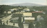
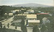
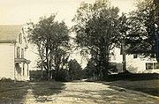
Greenfield, New Hampshire
Encyclopedia
Greenfield is a town in Hillsborough County
, New Hampshire
, United States
. The population was 1,749 at the 2010 census. Greenfield is home to the Crotched Mountain Rehabilitation Center, to Greenfield State Park, and to part of the Wapack Trail
.
 Originally known as "Lyndeborough
Addition", the area was first settled by the Lynde family in 1753. Separated from the nearest church and school by the Monadnock hills, the residents successfully petitioned to form a new town in 1791, using the name "Greenfield" to highlight the area's level, fertile ground.
In 1953, the Crotched Mountain Rehabilitation Center began operation in Greenfield. Established by Harry Gregg, the facility on Crotched Mountain originally treated for polio, cerebral palsy
, spina bifida
and other physical and neurological disabilities. A center for adult rehabilitation would open in 1961, and a rehabilitation center for adults with brain injuries in 1986. The complex today provides service to over 2,000 children and adults. In 2004, it unveiled the first wheelchair-accessible treehouse
in New Hampshire
.
Greenfield is home to the Yankee Siege, considered the most powerful (current) trebuchet
in the world, which has participated in the annual World Championship Punkin' Chunkin' Contest in Sussex County, Delaware
since 2004. The farthest official toss is 1897 feet (578.2 m) as of 2008, although there are unofficial reports of 2000 foot throws as of 2009.
, the town has a total area of 26.6 square miles (68.9 km²), of which 26.1 square miles (67.6 km²) is land and 0.5 square miles (1.3 km²) is water, comprising 2.09% of the town. Greenfield is drained by Stony Brook
, Otter Brook and the Contoocook River
; the town lies fully within the Merrimack River
watershed
. North Pack Monadnock
Mountain, elevation 2276 feet (693.7 m) above sea level
, is the northernmost summit of the Wapack Range
and the highest point in Greenfield.
 As of the census
of 2000, there were 1,657 people, 563 households, and 405 families residing in the town. The population density
was 65.1 people per square mile (25.1/km²). There were 640 housing units at an average density of 25.1 per square mile (9.7/km²). The racial makeup of the town was 97.28% White, 0.72% African American, 0.84% Native American, 0.24% Asian, 0.48% from other races
, and 0.42% from two or more races. Hispanic or Latino of any race were 0.60% of the population.
There were 563 households out of which 38.9% had children under the age of 18 living with them, 60.0% were married couples
living together, 8.0% had a female householder with no husband present, and 27.9% were non-families. 19.5% of all households were made up of individuals and 4.3% had someone living alone who was 65 years of age or older. The average household size was 2.69 and the average family size was 3.12.
 In the town the population was spread out with 30.8% under the age of 18, 7.3% from 18 to 24, 32.1% from 25 to 44, 22.8% from 45 to 64, and 7.1% who were 65 years of age or older. The median age was 34 years. For every 100 females there were 104.1 males. For every 100 females age 18 and over, there were 105.9 males.
The median income for a household in the town was $48,833, and the median income for a family was $56,250. Males had a median income of $36,250 versus $24,438 for females. The per capita income
for the town was $19,895. About 2.4% of families and 5.4% of the population were below the poverty line, including 6.9% of those under age 18 and 8.5% of those age 65 or over.
Hillsborough County, New Hampshire
-Demographics:As of the census of 2000, there were 380,841 people, 144,455 households, and 98,807 families residing in the county. The population density was 435 people per square mile . There were 149,961 housing units at an average density of 171 per square mile...
, New Hampshire
New Hampshire
New Hampshire is a state in the New England region of the northeastern United States of America. The state was named after the southern English county of Hampshire. It is bordered by Massachusetts to the south, Vermont to the west, Maine and the Atlantic Ocean to the east, and the Canadian...
, United States
United States
The United States of America is a federal constitutional republic comprising fifty states and a federal district...
. The population was 1,749 at the 2010 census. Greenfield is home to the Crotched Mountain Rehabilitation Center, to Greenfield State Park, and to part of the Wapack Trail
Wapack Trail
The Wapack Trail is one of the oldest public, interstate hiking trails in the United States. Opened in 1923, it follows the Wapack Range north-south for , between Mount Watatic in Ashburnham, Massachusetts and North Pack Monadnock mountain in Greenfield, New Hampshire...
.
History
Lyndeborough, New Hampshire
Lyndeborough is a town in Hillsborough County, New Hampshire, United States. The population was 1,683 at the 2010 census.- History :Originally granted by the Massachusetts General Court to veterans of New England's first war with Canada from Salem, Massachusetts, the area was known as Salem-Canada...
Addition", the area was first settled by the Lynde family in 1753. Separated from the nearest church and school by the Monadnock hills, the residents successfully petitioned to form a new town in 1791, using the name "Greenfield" to highlight the area's level, fertile ground.
In 1953, the Crotched Mountain Rehabilitation Center began operation in Greenfield. Established by Harry Gregg, the facility on Crotched Mountain originally treated for polio, cerebral palsy
Cerebral palsy
Cerebral palsy is an umbrella term encompassing a group of non-progressive, non-contagious motor conditions that cause physical disability in human development, chiefly in the various areas of body movement....
, spina bifida
Spina bifida
Spina bifida is a developmental congenital disorder caused by the incomplete closing of the embryonic neural tube. Some vertebrae overlying the spinal cord are not fully formed and remain unfused and open. If the opening is large enough, this allows a portion of the spinal cord to protrude through...
and other physical and neurological disabilities. A center for adult rehabilitation would open in 1961, and a rehabilitation center for adults with brain injuries in 1986. The complex today provides service to over 2,000 children and adults. In 2004, it unveiled the first wheelchair-accessible treehouse
Tree house
Tree houses, treehouses, or tree forts, are platforms or buildings constructed around, next to or among the trunk or branches of one or more mature trees while above ground level...
in New Hampshire
New Hampshire
New Hampshire is a state in the New England region of the northeastern United States of America. The state was named after the southern English county of Hampshire. It is bordered by Massachusetts to the south, Vermont to the west, Maine and the Atlantic Ocean to the east, and the Canadian...
.
Greenfield is home to the Yankee Siege, considered the most powerful (current) trebuchet
Trebuchet
A trebuchet is a siege engine that was employed in the Middle Ages. It is sometimes called a "counterweight trebuchet" or "counterpoise trebuchet" in order to distinguish it from an earlier weapon that has come to be called the "traction trebuchet", the original version with pulling men instead of...
in the world, which has participated in the annual World Championship Punkin' Chunkin' Contest in Sussex County, Delaware
Sussex County, Delaware
Sussex County is a county located in the southern part of the U.S. state of Delaware. As of 2010 the population was 197,145, an increase of 25.9% over the previous decade. The county seat is Georgetown. The Seaford Micropolitan Statistical Area includes all of Sussex County.Sussex County is...
since 2004. The farthest official toss is 1897 feet (578.2 m) as of 2008, although there are unofficial reports of 2000 foot throws as of 2009.
Geography
According to the United States Census BureauUnited States Census Bureau
The United States Census Bureau is the government agency that is responsible for the United States Census. It also gathers other national demographic and economic data...
, the town has a total area of 26.6 square miles (68.9 km²), of which 26.1 square miles (67.6 km²) is land and 0.5 square miles (1.3 km²) is water, comprising 2.09% of the town. Greenfield is drained by Stony Brook
Stony Brook (Souhegan River)
Stony Brook is a river located in southern New Hampshire in the United States. It is a tributary of the Souhegan River, which flows to the Merrimack River and ultimately to the Gulf of Maine....
, Otter Brook and the Contoocook River
Contoocook River
The Contoocook River is a river in New Hampshire. It flows from Pool Pond and Contoocook Lake on the Jaffrey/Rindge border to Penacook , where it empties into the Merrimack River. It is one of only a few rivers in New Hampshire that flow in a predominantly northward direction...
; the town lies fully within the Merrimack River
Merrimack River
The Merrimack River is a river in the northeastern United States. It rises at the confluence of the Pemigewasset and Winnipesaukee rivers in Franklin, New Hampshire, flows southward into Massachusetts, and then flows northeast until it empties into the Atlantic Ocean at Newburyport...
watershed
Drainage basin
A drainage basin is an extent or an area of land where surface water from rain and melting snow or ice converges to a single point, usually the exit of the basin, where the waters join another waterbody, such as a river, lake, reservoir, estuary, wetland, sea, or ocean...
. North Pack Monadnock
North Pack Monadnock
North Pack Monadnock or North Pack Monadnock Mountain is a monadnock located in south-central New Hampshire, at the northern end of the Wapack Range of mountains. It lies within Greenfield and Temple, New Hampshire; the Wapack Trail traverses the mountain. Ledges on the summit offer long views...
Mountain, elevation 2276 feet (693.7 m) above sea level
Sea level
Mean sea level is a measure of the average height of the ocean's surface ; used as a standard in reckoning land elevation...
, is the northernmost summit of the Wapack Range
Wapack Range
The Wapack Range, sometimes referred to as the Pack Monadnock Range, is a 20-mile range of mountains in south-central New Hampshire and adjacent Massachusetts. The range is considered very scenic and rugged with many bare summits and ledges ranging from 1,800 feet to 2,290 feet. The 22 mile Wapack...
and the highest point in Greenfield.
Demographics
Census
A census is the procedure of systematically acquiring and recording information about the members of a given population. It is a regularly occurring and official count of a particular population. The term is used mostly in connection with national population and housing censuses; other common...
of 2000, there were 1,657 people, 563 households, and 405 families residing in the town. The population density
Population density
Population density is a measurement of population per unit area or unit volume. It is frequently applied to living organisms, and particularly to humans...
was 65.1 people per square mile (25.1/km²). There were 640 housing units at an average density of 25.1 per square mile (9.7/km²). The racial makeup of the town was 97.28% White, 0.72% African American, 0.84% Native American, 0.24% Asian, 0.48% from other races
Race (United States Census)
Race and ethnicity in the United States Census, as defined by the Federal Office of Management and Budget and the United States Census Bureau, are self-identification data items in which residents choose the race or races with which they most closely identify, and indicate whether or not they are...
, and 0.42% from two or more races. Hispanic or Latino of any race were 0.60% of the population.
There were 563 households out of which 38.9% had children under the age of 18 living with them, 60.0% were married couples
Marriage
Marriage is a social union or legal contract between people that creates kinship. It is an institution in which interpersonal relationships, usually intimate and sexual, are acknowledged in a variety of ways, depending on the culture or subculture in which it is found...
living together, 8.0% had a female householder with no husband present, and 27.9% were non-families. 19.5% of all households were made up of individuals and 4.3% had someone living alone who was 65 years of age or older. The average household size was 2.69 and the average family size was 3.12.
The median income for a household in the town was $48,833, and the median income for a family was $56,250. Males had a median income of $36,250 versus $24,438 for females. The per capita income
Per capita income
Per capita income or income per person is a measure of mean income within an economic aggregate, such as a country or city. It is calculated by taking a measure of all sources of income in the aggregate and dividing it by the total population...
for the town was $19,895. About 2.4% of families and 5.4% of the population were below the poverty line, including 6.9% of those under age 18 and 8.5% of those age 65 or over.