
Wapack Trail
Encyclopedia
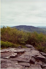
The Wapack Trail is one of the oldest public, interstate hiking trails in the United States
. Opened in 1923, it follows the Wapack Range
north-south for 21 miles (33.8 km), between Mount Watatic
in Ashburnham, Massachusetts
and North Pack Monadnock
mountain in Greenfield
, New Hampshire
. It is designed primarily for day use by hikers, with minimal camping facilities.
The trail passes through the Massachusetts towns of Ashburnham and Ashby
, and the New Hampshire towns of New Ipswich
, Temple
, Sharon
, Peterborough
, and Greenfield. It also goes over Temple Mountain
, and through Miller State Park
and the Wapack
National Wildlife Refuge
, as well as numerous privately owned parcels of land.
The trail is overseen by Friends of the Wapack, a non-profit group. Aside from upgrading and maintaining the trail, the group is trying to have the entire length preserved from development.
The southern part of the Wapack Trail overlaps with the northern part of the Midstate Trail.
between Allen Chamberlain, who later became president of the Appalachian Mountain Club
, and Jaffrey farmer Albert Annett while overlooking the Wapack Range
, then known as the Boundary Mountains. The two talked about the possibility of a skyline trail along the ridge of the Boundary Mountains from Mt. Watatic to North Pack Monadnock. Later, Albert brought the idea to fellow farmers Frank Robbins and Marion Buck of Rindge, New Hampshire
. The three started cutting the trail near the end of the summer using hand tools. The trail was opened in 1923. Buck named it by joining the Wa from Mt. Watatic and Pack from North Pack Monadnock, and soon the Boundary Mountains became known as the Wapack Range.
18 miles (29 km) race covers the southern part of the trail from the Windblown cross-country ski area to Mount Watatic
and back.
United States
The United States of America is a federal constitutional republic comprising fifty states and a federal district...
. Opened in 1923, it follows the Wapack Range
Wapack Range
The Wapack Range, sometimes referred to as the Pack Monadnock Range, is a 20-mile range of mountains in south-central New Hampshire and adjacent Massachusetts. The range is considered very scenic and rugged with many bare summits and ledges ranging from 1,800 feet to 2,290 feet. The 22 mile Wapack...
north-south for 21 miles (33.8 km), between Mount Watatic
Mount Watatic
Mount Watatic is a monadnock located on the Massachusetts-New Hampshire border, at the southern end of the Wapack Range of mountains. It lies within Ashburnham, Massachusetts, Ashby, Massachusetts, and New Ipswich, New Hampshire; the Wapack Trail and the Midstate Trail both cross the mountain...
in Ashburnham, Massachusetts
Ashburnham, Massachusetts
As of the census of 2000, there were 5,546 people, 1,929 households, and 1,541 families residing in the town. The population density was 143.4 people per square mile . There were 2,204 housing units at an average density of 57.0 per square mile...
and North Pack Monadnock
North Pack Monadnock
North Pack Monadnock or North Pack Monadnock Mountain is a monadnock located in south-central New Hampshire, at the northern end of the Wapack Range of mountains. It lies within Greenfield and Temple, New Hampshire; the Wapack Trail traverses the mountain. Ledges on the summit offer long views...
mountain in Greenfield
Greenfield, New Hampshire
Greenfield is a town in Hillsborough County, New Hampshire, United States. The population was 1,749 at the 2010 census. Greenfield is home to the Crotched Mountain Rehabilitation Center, to Greenfield State Park, and to part of the Wapack Trail.- History :...
, New Hampshire
New Hampshire
New Hampshire is a state in the New England region of the northeastern United States of America. The state was named after the southern English county of Hampshire. It is bordered by Massachusetts to the south, Vermont to the west, Maine and the Atlantic Ocean to the east, and the Canadian...
. It is designed primarily for day use by hikers, with minimal camping facilities.
The trail passes through the Massachusetts towns of Ashburnham and Ashby
Ashby, Massachusetts
Ashby is a town in Middlesex County, Massachusetts, United States. The population was 3,120 as of the 2010 census.-Geography:According to the United States Census Bureau, the town has a total area of , of which is land and is water....
, and the New Hampshire towns of New Ipswich
New Ipswich, New Hampshire
New Ipswich is a town in Hillsborough County, New Hampshire, United States. The population was 5,099 at the 2010 census. New Ipswich, situated on the Massachusetts border, includes the villages of Bank, Davis, Gibson Four Corners, Highbridge, New Ipswich Center, Smithville, and Wilder, though these...
, Temple
Temple, New Hampshire
Temple is a town in Hillsborough County, New Hampshire, United States. The population was 1,366 at the 2010 census.- History :Incorporated in 1768, Temple takes its name from colonial governor John Wentworth's lieutenant governor, John Temple.- Geography :...
, Sharon
Sharon, New Hampshire
Sharon is a town in Hillsborough County, New Hampshire, United States. The population was 352 at the 2010 census.-History:Settled in 1738, Sharon was originally a part of Peterborough...
, Peterborough
Peterborough, New Hampshire
Peterborough is a town in Hillsborough County, New Hampshire, United States. The population was 6,284 at the 2010 census. Home to the MacDowell Art Colony, the town is a popular tourist destination....
, and Greenfield. It also goes over Temple Mountain
Temple Mountain
Temple Mountain is a monadnock located in south-central New Hampshire within the Wapack Range of mountains. It lies within Sharon and Temple, New Hampshire; the Wapack Trail traverses the mountain, and the northern face includes the Temple Mountain Reservation, owned by the state...
, and through Miller State Park
Miller State Park
Miller State Park is the oldest state-run park in New Hampshire, a state in the New England region of the United States. It is mostly located in Peterborough.The park is centered on Pack Monadnock, the 2,290 foot mountain...
and the Wapack
Wapack National Wildlife Refuge
Wapack National Wildlife Refuge was New Hampshire's first refuge and was established through a donation in 1972. The refuge is located about west of Nashua, New Hampshire and encompasses the North Pack Monadnock Mountain...
National Wildlife Refuge
National Wildlife Refuge
National Wildlife Refuge is a designation for certain protected areas of the United States managed by the United States Fish and Wildlife Service. The National Wildlife Refuge System is the world's premiere system of public lands and waters set aside to conserve America's fish, wildlife and plants...
, as well as numerous privately owned parcels of land.
The trail is overseen by Friends of the Wapack, a non-profit group. Aside from upgrading and maintaining the trail, the group is trying to have the entire length preserved from development.
The southern part of the Wapack Trail overlaps with the northern part of the Midstate Trail.
History
The trail was born in a conversation in the summer of 1922 at the Shattuck Inn in Jaffrey, New HampshireJaffrey, New Hampshire
Jaffrey is a town in Cheshire County, New Hampshire, United States. The population was 5,457 at the 2010 census.The primary settlement in town, where 2,757 people resided at the 2010 census, is defined as the Jaffrey census-designated place and is located along the Contoocook River at the...
between Allen Chamberlain, who later became president of the Appalachian Mountain Club
Appalachian Mountain Club
The Appalachian Mountain Club is one of the United States' oldest outdoor groups. Created in 1876 to explore and preserve the White Mountains in New Hampshire, it has expanded throughout the northeastern U.S., with 12 chapters stretching from Maine to Washington, D.C...
, and Jaffrey farmer Albert Annett while overlooking the Wapack Range
Wapack Range
The Wapack Range, sometimes referred to as the Pack Monadnock Range, is a 20-mile range of mountains in south-central New Hampshire and adjacent Massachusetts. The range is considered very scenic and rugged with many bare summits and ledges ranging from 1,800 feet to 2,290 feet. The 22 mile Wapack...
, then known as the Boundary Mountains. The two talked about the possibility of a skyline trail along the ridge of the Boundary Mountains from Mt. Watatic to North Pack Monadnock. Later, Albert brought the idea to fellow farmers Frank Robbins and Marion Buck of Rindge, New Hampshire
Rindge, New Hampshire
Rindge is a town in Cheshire County, New Hampshire, United States. The population was 6,014 at the 2010 census. Rindge is home to Franklin Pierce University, the Cathedral of the Pines, and part of Annett State Forest.-Native American inhabitants:...
. The three started cutting the trail near the end of the summer using hand tools. The trail was opened in 1923. Buck named it by joining the Wa from Mt. Watatic and Pack from North Pack Monadnock, and soon the Boundary Mountains became known as the Wapack Range.
Trail running races
There are two races on the trail. A race in May has a 21.5 miles (34.6 km) version which goes the whole length of the trail and a longer out-and-back version. A Labor DayLabor Day
Labor Day is a United States federal holiday observed on the first Monday in September that celebrates the economic and social contributions of workers.-History:...
18 miles (29 km) race covers the southern part of the trail from the Windblown cross-country ski area to Mount Watatic
Mount Watatic
Mount Watatic is a monadnock located on the Massachusetts-New Hampshire border, at the southern end of the Wapack Range of mountains. It lies within Ashburnham, Massachusetts, Ashby, Massachusetts, and New Ipswich, New Hampshire; the Wapack Trail and the Midstate Trail both cross the mountain...
and back.