
Greenbrier River Watershed Association
Encyclopedia
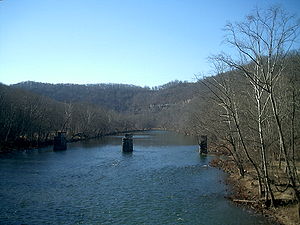
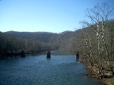
Greenbrier River
The Greenbrier River is a tributary of the New River, long, in southeastern West Virginia, USA. Via the New, Kanawha and Ohio Rivers, it is part of the watershed of the Mississippi River, draining an area of...
Watershed Association is one of the oldest watershed associations in the state of West Virginia
West Virginia
West Virginia is a state in the Appalachian and Southeastern regions of the United States, bordered by Virginia to the southeast, Kentucky to the southwest, Ohio to the northwest, Pennsylvania to the northeast and Maryland to the east...
, currently on its 15th year of existence. It has supported the creation of other watershed associations throughout the state and maintains a policy of "upstream courtesy" and "downstream courtesy" with its neighbors.
Mission statement
In existence for 15 years, its mission statement is as follows:
The Greenbrier RiverGreenbrier RiverThe Greenbrier River is a tributary of the New River, long, in southeastern West Virginia, USA. Via the New, Kanawha and Ohio Rivers, it is part of the watershed of the Mississippi River, draining an area of...
should be saved as a legacy. It is an essential part of our lives that enriches and inspires us.
The watershedDrainage basinA drainage basin is an extent or an area of land where surface water from rain and melting snow or ice converges to a single point, usually the exit of the basin, where the waters join another waterbody, such as a river, lake, reservoir, estuary, wetland, sea, or ocean...
is a unique ecosystemEcosystemAn ecosystem is a biological environment consisting of all the organisms living in a particular area, as well as all the nonliving , physical components of the environment with which the organisms interact, such as air, soil, water and sunlight....
with rich varieties of aquaticAquatic animalAn aquatic animal is an animal, either vertebrate or invertebrate, which lives in water for most or all of its life. It may breathe air or extract its oxygen from that dissolved in water through specialised organs called gills, or directly through its skin. Natural environments and the animals that...
, riparian, and upland wildlifeWildlifeWildlife includes all non-domesticated plants, animals and other organisms. Domesticating wild plant and animal species for human benefit has occurred many times all over the planet, and has a major impact on the environment, both positive and negative....
, tributaries, farmland, forest, people, and communities.
Our purpose is to promote the maintenance, preservation, protection and restoration of the ecological integrity of the Greenbrier RiverGreenbrier RiverThe Greenbrier River is a tributary of the New River, long, in southeastern West Virginia, USA. Via the New, Kanawha and Ohio Rivers, it is part of the watershed of the Mississippi River, draining an area of...
and its watershed.
Projects
The GRWA is a 501(c)3 nonprofit that partners with other environmental nonprofits, government organizations, and like-minded groups to promote the values of the watershed in the hopes that the public will understand its unique riparian resources and thus recognize its worth. The Board of the GRWA is composed of cavers, farmers, developers, teachers, and other diverse individuals that unite in their love for the Greenbrier. They work with schools and civic groups to teach classes, organize field trips, and support similar organizations that protect the watershed in a sensible and proactive manner.Outreach
Unlike the majority of the watersheds in West Virginia, the GRWA's webpage is centered around the watershed itself, not the organization. It survives on grants and public support (primarily membership donations), to assist the public with issues such as Nonpoint source pollutionNonpoint source pollution
Nonpoint source pollution refers to both water and air pollution from diffuse sources. Nonpoint source water pollution affects a water body from sources such as polluted runoff from agricultural areas draining into a river, or wind-borne debris blowing out to sea. Nonpoint source air pollution...
, Water Quality, Water Quantity, protection of forests to alleviate pollution, prevention of substandard and/or illegal developments, injection well
Injection well
An injection well is a vertical pipe in the ground into which water, other liquids, or gases are pumped or allowed to flow.-Waste disposal: One application is waste water disposal, in which treated waste water is injected into the ground between impermeable layers of rocks to avoid polluting fresh...
s, using sinkhole
Sinkhole
A sinkhole, also known as a sink, shake hole, swallow hole, swallet, doline or cenote, is a natural depression or hole in the Earth's surface caused by karst processes — the chemical dissolution of carbonate rocks or suffosion processes for example in sandstone...
s and cave systems for trash disposal, leaking septic tank
Septic tank
A septic tank is a key component of the septic system, a small-scale sewage treatment system common in areas with no connection to main sewage pipes provided by local governments or private corporations...
s, water sampling, straightpipes, and wastewater treatment plant
Sewage treatment
Sewage treatment, or domestic wastewater treatment, is the process of removing contaminants from wastewater and household sewage, both runoff and domestic. It includes physical, chemical, and biological processes to remove physical, chemical and biological contaminants...
issues. The Clean Water Act of 1972 has enabled the GRWA to help citizens seek legal, effective methods of improving their waters for the benefit of public health.
Riffle
Riffle
A Riffle is a short, relatively shallow and coarse-bedded length of stream over which the stream flows at higher velocity and higher turbulence than it normally does in comparison to a pool....
s is the GRWA newsletter, and published on a quarterly basis. Submissions from members are strongly encouraged and nearly a third of its members are out of state. Riffles are the shallow, oxygen-rich rapids of a river, which is as full of diverse life as a coral reef but often taken for granted and overlooked.
Members may join on a family membership ($30), or single ($25) or youth ($10). Donations of any amount are accepted as they are a valuable source of in-kind match funding with state or federal assistance.
Geography
The Greenbrier River Watershed Association currently resides in LewisburgLewisburg, West Virginia
Lewisburg is a city in Greenbrier County, West Virginia, United States. The population was 3,830 at the 2010 census. It is the county seat of Greenbrier County.-Geography:Lewisburg is located at ....
, West Virginia
West Virginia
West Virginia is a state in the Appalachian and Southeastern regions of the United States, bordered by Virginia to the southeast, Kentucky to the southwest, Ohio to the northwest, Pennsylvania to the northeast and Maryland to the east...
at 120 W. Washington Street. Their mailing address is PO BOX 1419 Lewisburg, WV 24901. The office serves the entirety of the Greenbrier River
Greenbrier River
The Greenbrier River is a tributary of the New River, long, in southeastern West Virginia, USA. Via the New, Kanawha and Ohio Rivers, it is part of the watershed of the Mississippi River, draining an area of...
Watershed. A second watershed, Friends of the Lower Greenbrier River, split off from the GRWA to concentrate on riparian issues in the lower half of the watershed. Both are within the West Virginia Southern Basin, which drains to the New River at Hinton
Hinton, West Virginia
Hinton is a city in Summers County, West Virginia, United States. The population was 2,880 at the 2000 census. It is the county seat of Summers County. Hinton was established in 1873 and chartered in 1897. Hinton was named for John "Jack" Hinton, a prominent lawyer of Summers County and husband of...
in Summers County. Their primary state assistance and consultation comes from the West Virginia Department of Environmental Protection's Southern Basin Coordinator, Jennifer Dupree.
Counties and Subwatersheds
| Pocahontas County Pocahontas County, West Virginia As of the census of 2000, there were 9,131 people, 835 households, and 527 families residing in the county. The population density was 10 people per square mile . There were 7,594 housing units at an average density of 8 per square mile... |
Greenbrier County | Monroe County Monroe County, West Virginia As of the census of 2000, there were 14,583 people, 5,447 households, and 3,883 families residing in the county. The population density was 31 people per square mile . There were 7,267 housing units at an average density of 15 per square mile... |
Summers County |
|---|---|---|---|
| Knapp Creek | Milligan Creek | Second Creek | Pence Springs |
| Swago Creek | Spring Creek Spring Creek, West Virginia Spring Creek is an unincorporated community in Greenbrier County, West Virginia, United States. Spring Creek is located on the Greenbrier River south of Falling Spring.... |
Kitchen Creek | Eagle Branch |
| East Fork | Muddy Creek | Plankcabin Creek | Big Creek |
Pocahontas County: Birthplace of Rivers
The Greenbrier RiverGreenbrier River
The Greenbrier River is a tributary of the New River, long, in southeastern West Virginia, USA. Via the New, Kanawha and Ohio Rivers, it is part of the watershed of the Mississippi River, draining an area of...
begins at Durbin
Durbin, West Virginia
Durbin is a town in Pocahontas County, West Virginia, United States. The population was 262 at the 2000 census.-Geography:Durbin is situated in the northern part of Pocahontas County at the confluence of the East and West Forks of the Greenbrier River. It is thus the starting point of the...
in Pocahontas County
Pocahontas County, West Virginia
As of the census of 2000, there were 9,131 people, 835 households, and 527 families residing in the county. The population density was 10 people per square mile . There were 7,594 housing units at an average density of 8 per square mile...
, but the watershed is involved with the upper drainage portions above Durbin, which includes places like Blister Swamp. It flows through the center of Pocahontas County
Pocahontas County, West Virginia
As of the census of 2000, there were 9,131 people, 835 households, and 527 families residing in the county. The population density was 10 people per square mile . There were 7,594 housing units at an average density of 8 per square mile...
, "the Birthplace of Rivers." Pocahontas County is sparsely populated, due to the Monongahela National Forest
Monongahela National Forest
The Monongahela National Forest is a national forest located in the Allegheny Mountains of eastern West Virginia, USA. It protects over of federally-owned land within a proclamation boundary that includes much of the Potomac Highlands Region and portions of 10 counties.The MNF includes some...
. This legally designated National Forest supports a great deal of the clean water within the watershed, and water quality degrades once the river flows out of the Forest's territory and into the more populated Greenbrier County. The spring Great Greenbrier River Race in Marlinton and summer's Durbin Days in Durbin
Durbin, West Virginia
Durbin is a town in Pocahontas County, West Virginia, United States. The population was 262 at the 2000 census.-Geography:Durbin is situated in the northern part of Pocahontas County at the confluence of the East and West Forks of the Greenbrier River. It is thus the starting point of the...
draws large crowds every year. Pocahontas County
Pocahontas County, West Virginia
As of the census of 2000, there were 9,131 people, 835 households, and 527 families residing in the county. The population density was 10 people per square mile . There were 7,594 housing units at an average density of 8 per square mile...
contains much of the Greenbrier River Trail
Greenbrier River Trail
The Greenbrier River Trail is a rail trail operated by West Virginia State Parks. The trail is a long former railroad, now used for hiking, bicycling, ski-touring, horseback-riding, and wheel-chair use. The trail passes through numerous small towns and traverses 35 bridges and 2 tunnels as it...
, which is the longest Rail Trail
Rail trail
A rail trail is the conversion of a disused railway easement into a multi-use path, typically for walking, cycling and sometimes horse riding. The characteristics of former tracks—flat, long, frequently running through historical areas—are appealing for various development. The term sometimes also...
in West Virginia
West Virginia
West Virginia is a state in the Appalachian and Southeastern regions of the United States, bordered by Virginia to the southeast, Kentucky to the southwest, Ohio to the northwest, Pennsylvania to the northeast and Maryland to the east...
. The first USGS flow gauge station for the watershed is in the town of Buckeye
Buckeye, West Virginia
Buckeye is an unincorporated community in Pocahontas County, West Virginia, United States. Buckeye is located along U.S. Route 219 southwest of Marlinton. Buckeye has a post office with ZIP code 24924....
involving Swago Creek.
Greenbrier County: Land of Karst
The eastern half of Greenbrier County where the watershed rests is one of the world's densest karst stratas in the world with, "The Great Savannah" where sinkholes average at 18 km². Its water is threatened by development and ignorance of karst issues. Despite the fact that its sensitivity is a matter of record, many people claim ignorance of karst and the county government has no existing bond of commitment for its developers that would guarantee a building project will not be affected by the shifting caverns and sinkholes. The western side hosts the new Meadow RiverMeadow River
The Meadow River is a tributary of the Gauley River, making its headwaters in Greenbrier County and terminating in Nicholas County of West Virginia. It is named for the grassy meadows wetlands which its upper watershed drains, and from which it springs...
Watershed. Greenbrier County is known for its trout waters, farmland, rising development, historic 1812-and Civil War saltpetre caverns and tour caves: Lost World Caverns
Lost World Caverns
Lost World Caverns, located just outside of Lewisburg, West Virginia, is an underground natural series of caverns. In November 1973, the caverns were registered as a National Natural Landmark as they "feature terraced pedestal-like stalagmites, flowstone, curtains, rimstone, domepits, and...
and Organ Cave
Organ Cave
Organ Cave is a large and historic cave in Greenbrier County, West Virginia, USA. The surrounding community takes its name from the cave.In November 1973, the Organ Cave System — also known as the Organ-Hendricks Cave System — was registered as a National Natural Landmark for being "the largest...
, Inc. Many important Ice Age fossil discoveries have been found within the watershed here. Greenbrier County hosts the Riders of the Flood Outdoor Amphitheatre in Ronceverte, the State Fair of West Virginia
State Fair of West Virginia
The State Fair of West Virginia is an annual state fair for West Virginia. It is held annually in mid-August on the State Fairgrounds in Fairlea, near Lewisburg, West Virginia in the southeastern part of the state. The State Fairgrounds consists of a large open field for carnivals and...
and the Freshwater Folk Festival at the National Fish Hatchery at White Sulphur Springs
White Sulphur Springs, West Virginia
White Sulphur Springs is a city in Greenbrier County, West Virginia, United States. The population was 2,444 at the 2010 census.-Geography:White Sulphur Springs is located at ....
, and the GRWA tries to keep its presence at both events for outreach.
Monroe County: Land of Sinks
Monroe CountyMonroe County, West Virginia
As of the census of 2000, there were 14,583 people, 5,447 households, and 3,883 families residing in the county. The population density was 31 people per square mile . There were 7,267 housing units at an average density of 15 per square mile...
is a rich, agriculturally blessed county with fine apple orchards, wineries, trout water, historic springs, farmland, and saltpetre (saltpeter
Potassium nitrate
Potassium nitrate is a chemical compound with the formula KNO3. It is an ionic salt of potassium ions K+ and nitrate ions NO3−.It occurs as a mineral niter and is a natural solid source of nitrogen. Its common names include saltpetre , from medieval Latin sal petræ: "stone salt" or possibly "Salt...
)caves. Since settler times is has been called "the land of sinks" for its many sinkholes. One community is called Sinks Grove because of this terrain. It contains the Second Creek Watershed, which is maintained by Friends of THE Second Creek Watershed. The birthplace of American Paleontology
Paleontology
Paleontology "old, ancient", ὄν, ὀντ- "being, creature", and λόγος "speech, thought") is the study of prehistoric life. It includes the study of fossils to determine organisms' evolution and interactions with each other and their environments...
began in the late 18th-century with the discovery of the Megalonyx Jeffersonii (Thomas Jefferson's Three-toed Sloth) in its Haynes Cave
Haynes Cave
Haynes Cave is a cave within the Greenbrier River watershed in West Virginia. It sits within the complex hydrology of the historic Second Creek watershed in Monroe County....
. Haynes Cave is believed to be approximately 2 to 5 million years old. Monroe County
Monroe County, West Virginia
As of the census of 2000, there were 14,583 people, 5,447 households, and 3,883 families residing in the county. The population density was 31 people per square mile . There were 7,267 housing units at an average density of 15 per square mile...
has the USGS station on its side of the town of Alderson
Alderson, West Virginia
Alderson, a town in the US State of West Virginia, is split geographically by the Greenbrier River, with portions in both Greenbrier and Monroe Counties. Although split physically by the river, the town functions as one entity, including that of town government...
, West Virginia
West Virginia
West Virginia is a state in the Appalachian and Southeastern regions of the United States, bordered by Virginia to the southeast, Kentucky to the southwest, Ohio to the northwest, Pennsylvania to the northeast and Maryland to the east...
, where the public gleans much useful data about temperature
Temperature
Temperature is a physical property of matter that quantitatively expresses the common notions of hot and cold. Objects of low temperature are cold, while various degrees of higher temperatures are referred to as warm or hot...
, pH
PH
In chemistry, pH is a measure of the acidity or basicity of an aqueous solution. Pure water is said to be neutral, with a pH close to 7.0 at . Solutions with a pH less than 7 are said to be acidic and solutions with a pH greater than 7 are basic or alkaline...
, flow
Volumetric flow rate
The volumetric flow rate in fluid dynamics and hydrometry, is the volume of fluid which passes through a given surface per unit time...
, and dissolved oxygen. Much work has been launched in efforts to study the karstic hydrology
Hydrology
Hydrology is the study of the movement, distribution, and quality of water on Earth and other planets, including the hydrologic cycle, water resources and environmental watershed sustainability...
of this county. Recently the entire Second Creek Watershed was designated an historic watershed by the state of West Virginia
West Virginia
West Virginia is a state in the Appalachian and Southeastern regions of the United States, bordered by Virginia to the southeast, Kentucky to the southwest, Ohio to the northwest, Pennsylvania to the northeast and Maryland to the east...
.
Summers County: Confluence of Rivers
Summers County is the least karstKARST
Kilometer-square Area Radio Synthesis Telescope is a Chinese telescope project to which FAST is a forerunner. KARST is a set of large spherical reflectors on karst landforms, which are bowlshaped limestone sinkholes named after the Kras region in Slovenia and Northern Italy. It will consist of...
ic of all the watershed counties, with only 6 karstic springs and rockledges outnumbering caves. Summers County is warm, with weather influenced by the New River and many vernal pool
Vernal pool
Vernal pools, also called vernal ponds or ephemeral pools, are temporary pools of water. They are usually devoid of fish, and thus allow the safe development of natal amphibian and insect species...
s and streams feed the lower Greenbrier in the summer. Native American
Indigenous peoples of the Americas
The indigenous peoples of the Americas are the pre-Columbian inhabitants of North and South America, their descendants and other ethnic groups who are identified with those peoples. Indigenous peoples are known in Canada as Aboriginal peoples, and in the United States as Native Americans...
summer settlements grew crops along the long, flat floodplains in areas like Pence Springs. The last USGS station is in the town of Hilldale
Hilldale, West Virginia
Hilldale is an unincorporated community in Summers County, West Virginia, United States. Hilldale is located on West Virginia Route 3 and West Virginia Route 12 east of Hinton....
. The Greenbrier enters the Three Rivers Confluence at Hinton
Hinton, West Virginia
Hinton is a city in Summers County, West Virginia, United States. The population was 2,880 at the 2000 census. It is the county seat of Summers County. Hinton was established in 1873 and chartered in 1897. Hinton was named for John "Jack" Hinton, a prominent lawyer of Summers County and husband of...
where the waters of the Bluestone River
Bluestone River
The Bluestone River is a tributary of the New River, 77 mi long, in southwestern Virginia and southern West Virginia in the United States. Via the New, Kanawha and Ohio Rivers, it is part of the watershed of the Mississippi River...
, the New River, and the Greenbrier River
Greenbrier River
The Greenbrier River is a tributary of the New River, long, in southeastern West Virginia, USA. Via the New, Kanawha and Ohio Rivers, it is part of the watershed of the Mississippi River, draining an area of...
mix. Hinton hosts a Water Festival every year. Although the Greenbrier flows into the New River at Hinton, New River biota
Biota (ecology)
Biota are the total collection of organisms of a geographic region or a time period, from local geographic scales and instantaneous temporal scales all the way up to whole-planet and whole-timescale spatiotemporal scales. The biota of the Earth lives in the biosphere.-See...
such as the lamprey
Lamprey
Lampreys are a family of jawless fish, whose adults are characterized by a toothed, funnel-like sucking mouth. Translated from an admixture of Latin and Greek, lamprey means stone lickers...
cannot travel upstream because of Sandstone Falls, the 30th-largest waterfall in the world. This helps preserve the integrity of the Greenbrier's freshwater species. The National Park Service
National Park Service
The National Park Service is the U.S. federal agency that manages all national parks, many national monuments, and other conservation and historical properties with various title designations...
celebrates the role of the tributaries of the New River at the Sandstone Visitors Center in Sandstone, West Virginia
Sandstone, West Virginia
Sandstone is an unincorporated community in Summers County, West Virginia, United States. It lies along West Virginia Route 20 and the New River to the north of the city of Hinton, the county seat of Summers County. Its elevation is 1,352 feet...
.
Of Note
The Greenbrier provides an estimated 30% of all the water in the New River.The state's oldest Ginkgo Biloba tree is a 133-year old specimen planted in Lewisburg's New River Community and Technical College campus.
Railroads
Two of the three Historic Railroads in West Virginia are within the Greenbrier River Watershed: The Cass Scenic Railroad State Park
Cass Scenic Railroad State Park
Cass Scenic Railroad State Park is a State Park located in Cass, Pocahontas County, West Virginia.It consists of the Cass Scenic Railroad, an long heritage railroad that is owned by the state of West Virginia...
and the Durbin and Greenbrier Valley Railroad
Durbin and Greenbrier Valley Railroad
The Durbin and Greenbrier Valley Railroad is a heritage and freight railroad in the U.S. state of West Virginia. It operates the West Virginia State Rail Authority-owned Durbin Railroad and West Virginia Central Railroad , as well as the Shenandoah Valley Railroad in Virginia.-Trains:The DGVR...
. Unused railroad tracks have been restored into a 79-mile Greenbrier River Trail