
Greenbrier River Trail
Encyclopedia
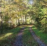
The Greenbrier River Trail is a rail trail
operated by West Virginia State Parks. The trail is a 77 miles (123.9 km) long former railroad, now used for hiking
, bicycling, ski-touring
, horseback-riding, and wheel-chair use. The trail passes through numerous small towns and traverses 35 bridges and 2 tunnels as it winds its way along the valley. Most of the trail is adjacent to the free-flowing Greenbrier River
and is surrounded by peaks of the Allegheny Mountains
.
Rail trail
A rail trail is the conversion of a disused railway easement into a multi-use path, typically for walking, cycling and sometimes horse riding. The characteristics of former tracks—flat, long, frequently running through historical areas—are appealing for various development. The term sometimes also...
operated by West Virginia State Parks. The trail is a 77 miles (123.9 km) long former railroad, now used for hiking
Hiking
Hiking is an outdoor activity which consists of walking in natural environments, often in mountainous or other scenic terrain. People often hike on hiking trails. It is such a popular activity that there are numerous hiking organizations worldwide. The health benefits of different types of hiking...
, bicycling, ski-touring
Cross-country skiing
Cross-country skiing is a winter sport in which participants propel themselves across snow-covered terrain using skis and poles...
, horseback-riding, and wheel-chair use. The trail passes through numerous small towns and traverses 35 bridges and 2 tunnels as it winds its way along the valley. Most of the trail is adjacent to the free-flowing Greenbrier River
Greenbrier River
The Greenbrier River is a tributary of the New River, long, in southeastern West Virginia, USA. Via the New, Kanawha and Ohio Rivers, it is part of the watershed of the Mississippi River, draining an area of...
and is surrounded by peaks of the Allegheny Mountains
Allegheny Mountains
The Allegheny Mountain Range , also spelled Alleghany, Allegany and, informally, the Alleghenies, is part of the vast Appalachian Mountain Range of the eastern United States and Canada...
.
Major Trailheads
| Trailhead | Milepost | |Directions | Map Coordinates |
|---|---|---|---|
| North Caldwell North Caldwell, West Virginia North Caldwell is an unincorporated community in Greenbrier County, West Virginia, United States. North Caldwell is located on U.S. Route 60 southeast of Lewisburg.... |
3.1 | 1 mi (1.6 km) N of  US 60 US 60U.S. Route 60 U.S. Route 60 is an east–west United States highway, running from the Atlantic Ocean on the east coast in Virginia to western Arizona. Despite the final "0" in its number, indicating a transcontinental designation, the 1926 route formerly ended in Springfield, Missouri, at its intersection... on Stone House Road |
37°47′37"N 80°22′50"W |
| Seebert Seebert, West Virginia Seebert is an unincorporated community in Pocahontas County, West Virginia, United States. Seebert is located on the Greenbrier River east of Hillsboro.... |
45.8 | at Seebert on County Rt. 27, about 2 miles (3.2 km) east of  US 219 US 219U.S. Route 219 U.S. Route 219 is a spur of U.S. Route 19. It runs for from West Seneca, New York at an interchange with Interstate 90, to Rich Creek, Virginia, intersecting at U.S. Route 460. U.S. 219 is found in New York, Pennsylvania, Maryland, West Virginia, and Virginia... |
38°07′36"N 80°10′33"W |
| Marlinton Marlinton, West Virginia Marlinton is a town in Pocahontas County, West Virginia, United States. The population was 1,204 at the 2000 census. It is the county seat of Pocahontas County.-History:... |
56.0 | at Marlinton on  WV 39 WV 39 |
38°13′18"N 80°05′39"W |
| Cass Cass, West Virginia Cass is an unincorporated census-designated place on the Greenbrier River in Pocahontas County, West Virginia, USA. As of the 2010 census, its population was 52... |
80.4 | at Slabtown, 0.5 mi (0.80467 km) S of Cass on  WV 66 at Deer Creek Road WV 66 at Deer Creek Road |
See also
- Greenbrier RiverGreenbrier RiverThe Greenbrier River is a tributary of the New River, long, in southeastern West Virginia, USA. Via the New, Kanawha and Ohio Rivers, it is part of the watershed of the Mississippi River, draining an area of...
- LewisburgLewisburg, West VirginiaLewisburg is a city in Greenbrier County, West Virginia, United States. The population was 3,830 at the 2010 census. It is the county seat of Greenbrier County.-Geography:Lewisburg is located at ....
- MarlintonMarlinton, West VirginiaMarlinton is a town in Pocahontas County, West Virginia, United States. The population was 1,204 at the 2000 census. It is the county seat of Pocahontas County.-History:...
- Greenbrier CountyGreenbrier County, West VirginiaAs of the census of 2000, there were 34,453 people, 14,571 households, and 9,922 families residing in the county. The population density was 34 people per square mile . There were 17,644 housing units at an average density of 17 per square mile...
- Pocahontas CountyPocahontas County, West VirginiaAs of the census of 2000, there were 9,131 people, 835 households, and 527 families residing in the county. The population density was 10 people per square mile . There were 7,594 housing units at an average density of 8 per square mile...