
Green Brook Flood Control Project
Encyclopedia
The Green Brook Flood Control Project is a flood control project in Somerset County
in central New Jersey
first proposed in the early 1970s in the wake of two major flooding events: a 1971 flood event and a major flood in August 1973, which ravaged the Green Brook and Raritan River
basins with flooding, causing millions in property damage and several deaths in central New Jersey.
 The worst flooding in the Green Brook basin occurs in Bound Brook
, which partially lies on a natural flood plain of the Raritan River at the junction of the Green Brook and Raritan River.
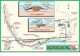
To address this flooding problem, the United States Army Corps of Engineers
has proposed the Green Brook Sub Basin Flood Control Project, which entails numerous flood wall
s, levee
s, channel diversions, widening projects and retention basin
s throughout the Green Brook basin.
in 1999 caused yet more property damage and deaths in the Green Brook basin, especially in Bound Brook, and reinvigorated the flood control project. As of 2006, two levees have been built on the western and eastern sides of Bound Brook. An important levee (R2) on the southwestern side of Bound Brook, which would prevent the Raritan River from flooding the downtown and nearby residential areas, is 99% completed as of September 2011. Full 150 year protection of downtown and nearby residential areas of Bound Brook will not be in place until closure gates are constructed and fully functional at two locations on the western and southern sides of Bound Brook.
 The April Nor'easter of 2007 flooded Bound Brook with the second highest crest ever recorded in the area, as the envisioned flood protection systems were not yet fully in place. However, the April 2007 flooding did reinvigorate efforts to complete the flood levee protection system around Bound Brook, to protect it from future flooding.
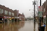
Flooding of downtown occurred in August 2011 when Hurricane Irene passed along the East Coast.
(NJDEP) are moving forward with two contracts for the Green Brook Flood Control Project, both of which are located in Bound Brook:
The new Talmadge Avenue Bridge that connects Bound Brook and Bridgewater, New Jersey is functionally complete as of April 2010. The replacement bridge was built to the height of the R2 Levee to prevent Middle Brook
and Raritan River waters from entering Bound Brook from the west. An early test of the newly raised Talmadge Avenue Bridge occurred in early March 2010 when the downtown area of Bound Brook received flood waters from the South Main Street railroad underpass, but the western section of Bound Brook was spared from the flooding by the completed portions of the R2 Levee and the newly raised Talmadge Avenue Bridge.
To improve water flow through Bound Brook, the former Conrail bridge over the Raritan River and its associated railroad embankment that were located east of Bound Brook were removed during 2007. The bridge and embankment, when they were in place, acted to block the river flow through the Bound Brook area. To build the main Bound Brook R2 levee, the bridge and embankment needed to be removed.
By March 2011, the $120 million profect was 90% completed and effective to prevent flooding during a major rainstorm. When Hurricane Irene passed along the East Coast in August 2011, flooding was not prevented but damage apparently mitigated by the not-yet-completed flood gate system.
A roadway bridge called the Sebrings Bridge, which crosses the Green Brook and links the towns of Green Brook, New Jersey and Middlesex, New Jersey
, will be replaced in 2010 and 2011, as part of the Green Brook Flood Control project. The bridge currently slows water flow in the Green Brook during periods of high water runoff and causes flooding in the areas upstream of the bridge. The new bridge will be widened and raised to ease water flow. Federal funding is in place for Fiscal Year 2011 for the bridge replacement. Replacement of the bridge also will allow for additional future flood mitigation measures in the areas adjacent to the bridge, such as additional flood walls and levees.
Somerset County, New Jersey
Somerset County is a county located in the U.S. state of New Jersey. In 2010, the population was 323,444. It is part of the New York Metropolitan Area. Its county seat is Somerville....
in central New Jersey
New Jersey
New Jersey is a state in the Northeastern and Middle Atlantic regions of the United States. , its population was 8,791,894. It is bordered on the north and east by the state of New York, on the southeast and south by the Atlantic Ocean, on the west by Pennsylvania and on the southwest by Delaware...
first proposed in the early 1970s in the wake of two major flooding events: a 1971 flood event and a major flood in August 1973, which ravaged the Green Brook and Raritan River
Raritan River
The Raritan River is a major river of central New Jersey in the United States. Its watershed drains much of the mountainous area of the central part of the state, emptying into the Raritan Bay on the Atlantic Ocean.-Description:...
basins with flooding, causing millions in property damage and several deaths in central New Jersey.
Bound Brook, New Jersey
Bound Brook is a borough in Somerset County, New Jersey, United States. At the United States 2010 Census, the population was 10,402.Bound Brook was originally incorporated as a town by an Act of the New Jersey Legislature on March 24, 1869, within portions of Bridgewater Township...
, which partially lies on a natural flood plain of the Raritan River at the junction of the Green Brook and Raritan River.
To address this flooding problem, the United States Army Corps of Engineers
United States Army Corps of Engineers
The United States Army Corps of Engineers is a federal agency and a major Army command made up of some 38,000 civilian and military personnel, making it the world's largest public engineering, design and construction management agency...
has proposed the Green Brook Sub Basin Flood Control Project, which entails numerous flood wall
Flood wall
A flood wall is a primarily vertical artificial barrier designed to temporarily contain the waters of a river or other waterway which may rise to unusual levels during seasonal or extreme weather events...
s, levee
Levee
A levee, levée, dike , embankment, floodbank or stopbank is an elongated naturally occurring ridge or artificially constructed fill or wall, which regulates water levels...
s, channel diversions, widening projects and retention basin
Retention basin
A retention basin is used to manage stormwater runoff to prevent flooding and downstream erosion, and improve water quality in an adjacent river, stream, lake or bay. Sometimes called a wet pond or wet detention basin, it is an artificial lake with vegetation around the perimeter, and includes a...
s throughout the Green Brook basin.
Floodings during the project
The Green Brook Flood Control project has languished for decades due to a lack of federal funding. Hurricane FloydHurricane Floyd
Hurricane Floyd was the sixth named storm, fourth hurricane, and third major hurricane in the 1999 Atlantic hurricane season. Floyd triggered the third largest evacuation in US history when 2.6 million coastal residents of five states were ordered from their homes as it approached...
in 1999 caused yet more property damage and deaths in the Green Brook basin, especially in Bound Brook, and reinvigorated the flood control project. As of 2006, two levees have been built on the western and eastern sides of Bound Brook. An important levee (R2) on the southwestern side of Bound Brook, which would prevent the Raritan River from flooding the downtown and nearby residential areas, is 99% completed as of September 2011. Full 150 year protection of downtown and nearby residential areas of Bound Brook will not be in place until closure gates are constructed and fully functional at two locations on the western and southern sides of Bound Brook.
Flooding of downtown occurred in August 2011 when Hurricane Irene passed along the East Coast.
Current status
The Army Corps of Engineers (ACOE) and the New Jersey Department of Environmental ProtectionNew Jersey Department of Environmental Protection
The New Jersey Department of Environmental Protection is a government agency in the U.S. state of New Jersey that is responsible for managing the state's natural resources and addressing issues related to pollution...
(NJDEP) are moving forward with two contracts for the Green Brook Flood Control Project, both of which are located in Bound Brook:
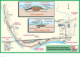
- 1. R2 Levee System – Construction of the R2 Levee System has commenced as of September 2009. A portion of the R2 Levee is now visible just south of Talmadge Avenue. Construction bids for the R2 Levee System, including the Raritan River levee, flood wall, and pump station were opened on September 29, 2008, and the contract was awarded to Scafar of Newark, NJ for $15.7 million. Funding to complete the R2 Levee System is in place. According to the Green Brook Flood Control Commission May 2008 meeting notes, work on the R2 Levee System will be completed 18 months after work begins, or approximately the end of 2010. The R2 Levee System will start in the southwestern part of Bound Brook on the south side of the new Talmadge Avenue Bridge, and briefly follow the Middle Brook's east bank, then loop around the southern side of Bound Brook along Raritan River's north bank, where the Raritan River creates the southern boundary of the borough, to an area slightly west of the Bound Brook train station. The R2 Levee System is designed to provide Bound Brook with protection from a 150-year flood level. However, the 150-year flood protection will only be achieved when the entire levee system is in place, including the two closure gates. The levee will be built to the height of the raised Talmage Avenue Bridge.
- 2. Closure Gates Along Raritan River – The full 150 year flood protection from the R2 Levee System will not be in place until two closure gates are completed that will prevent flood waters from entering Bound Brook. The gate closures will be across the New Jersey Transit railroad tracks on the western side of Bound Brook and at the South Main Street railroad underpass that leads to Queens Bridge. Work on the South Main Street railroad underpass closure gate will commence in June 2010, and is expected to be completed in November 2011. The New Jersey Transit railroad tracks closure gate is in the design stage as of April 2010 and contracts for its construction are expected to be awarded in 2010, if federal funding is sufficient.
The new Talmadge Avenue Bridge that connects Bound Brook and Bridgewater, New Jersey is functionally complete as of April 2010. The replacement bridge was built to the height of the R2 Levee to prevent Middle Brook
Middle Brook (New Jersey)
Middle Brook is a tributary of the Raritan River in Somerset, New Jersey in the United States. The stream can be referred to as Rha-weigh-weiros, a Native American name meaning "running from a deep hole", on early maps of the area....
and Raritan River waters from entering Bound Brook from the west. An early test of the newly raised Talmadge Avenue Bridge occurred in early March 2010 when the downtown area of Bound Brook received flood waters from the South Main Street railroad underpass, but the western section of Bound Brook was spared from the flooding by the completed portions of the R2 Levee and the newly raised Talmadge Avenue Bridge.
To improve water flow through Bound Brook, the former Conrail bridge over the Raritan River and its associated railroad embankment that were located east of Bound Brook were removed during 2007. The bridge and embankment, when they were in place, acted to block the river flow through the Bound Brook area. To build the main Bound Brook R2 levee, the bridge and embankment needed to be removed.
By March 2011, the $120 million profect was 90% completed and effective to prevent flooding during a major rainstorm. When Hurricane Irene passed along the East Coast in August 2011, flooding was not prevented but damage apparently mitigated by the not-yet-completed flood gate system.
Finderne Wetlands Mitigation Project
The Finderne Wetlands Mitigation Project (also known as Finderne Farms) is a wetlands project upstream of Bound Brook in Bridgewater, New Jersey that is tied into the Green Brook Flood Control project. When completed, Finderne Farms will serve as a Somerset County park with trails through wetlands and ballfields. More importantly, Finderne Farms will serve as an upstream wetland that will help to reduce flooding in the Raritan River valley by providing space for floodwaters to pool.A roadway bridge called the Sebrings Bridge, which crosses the Green Brook and links the towns of Green Brook, New Jersey and Middlesex, New Jersey
Middlesex, New Jersey
Middlesex is a Borough in Middlesex County, New Jersey, United States. As of the 2010 United States Census, the borough population was 13,635.Middlesex was incorporated as a borough by an Act of the New Jersey Legislature on April 9, 1913, from portions of Piscataway Township, based on the results...
, will be replaced in 2010 and 2011, as part of the Green Brook Flood Control project. The bridge currently slows water flow in the Green Brook during periods of high water runoff and causes flooding in the areas upstream of the bridge. The new bridge will be widened and raised to ease water flow. Federal funding is in place for Fiscal Year 2011 for the bridge replacement. Replacement of the bridge also will allow for additional future flood mitigation measures in the areas adjacent to the bridge, such as additional flood walls and levees.
External links
- U.S. Army Corps of Engineers Green Brook Sub Basin Page - Army Corps Green Brook Flood Control Project Website
- Green Brook Flood Control Commission - Official Project Website
- History of The Green Brook Flood Control Project
- Detailed Green Brook Flood Control Project Update U.S. Army Corps of Engineers Meeting With Local Officials - September 6, 2006
- Officials plead for further flood control funds $400 Million Needed to Complete Project, $40 Million to Fully Protect Bound Brook - April 19, 2006
- Lawmakers work to keep flood-control funds from drying up - January 11, 2006
- House panel approves $5 million for Green Brook Flood Control Project - May 18, 2005
River Gauge
- Raritan River Gauge, Bound Brook, New Jersey - Observation gauge approximately one-half mile west (upstream) of Bound Brook, NJ, just below Calco Dam. Main Street in Bound Brook floods when the river reaches a 30 foot stage.