

Greater Hartford
Encyclopedia
Connecticut
Connecticut is a state in the New England region of the northeastern United States. It is bordered by Rhode Island to the east, Massachusetts to the north, and the state of New York to the west and the south .Connecticut is named for the Connecticut River, the major U.S. river that approximately...
, centered on the state's capital of Hartford
Hartford, Connecticut
Hartford is the capital of the U.S. state of Connecticut. The seat of Hartford County until Connecticut disbanded county government in 1960, it is the second most populous city on New England's largest river, the Connecticut River. As of the 2010 Census, Hartford's population was 124,775, making...
.
Hartford's role as a focal point for the American insurance industry is known nationally. The vibrant music and arts scene defines the region's culture. Greater Hartford is also home to the Travelers Championship golf tournament (formerly known as the Greater Hartford Open/Buick Championship
Buick Championship
The Travelers Championship is a golf tournament on the PGA Tour. It is the second most attended PGA Tour event annually only behind the Waste Management Phoenix Open. In 2011, the tournament attracted 240,000 fans for the week and 70,000 fans on Sunday. In 2002 the tournament set a record...
).
This area of Connecticut is different from other parts of the state in that it is not dependent on out-of-state metropolitan areas such as New York City
New York City
New York is the most populous city in the United States and the center of the New York Metropolitan Area, one of the most populous metropolitan areas in the world. New York exerts a significant impact upon global commerce, finance, media, art, fashion, research, technology, education, and...
or Boston
Boston
Boston is the capital of and largest city in Massachusetts, and is one of the oldest cities in the United States. The largest city in New England, Boston is regarded as the unofficial "Capital of New England" for its economic and cultural impact on the entire New England region. The city proper had...
. It is on the fairly level land of the Connecticut River
Connecticut River
The Connecticut River is the largest and longest river in New England, and also an American Heritage River. It flows roughly south, starting from the Fourth Connecticut Lake in New Hampshire. After flowing through the remaining Connecticut Lakes and Lake Francis, it defines the border between the...
valley with soil less rocky than that of other areas in the state.
The region's economy is closely tied with Springfield, Massachusetts
Springfield, Massachusetts
Springfield is the most populous city in Western New England, and the seat of Hampden County, Massachusetts, United States. Springfield sits on the eastern bank of the Connecticut River near its confluence with three rivers; the western Westfield River, the eastern Chicopee River, and the eastern...
, as Hartford and Springfield are twin cities, only 25 miles apart. The area is served by Bradley International Airport
Bradley International Airport
Bradley International Airport is a joint civil-military public airport located in Windsor Locks on the border with East Granby and Suffield, in Hartford County, Connecticut, United States. It is owned by the State of Connecticut....
, shared with Springfield. Although contiguous to Springfield's northern border, Westover Metropolitan Airport
Westover Metropolitan Airport
For the military airport use of this facility, see Westover Joint Air Reserve BaseWestover Metropolitan Airport is a civilian airline, and general aviation airport located in the Massachusetts communities of Chicopee, Granby, and Ludlow, near the cities of Springfield and Holyoke, Massachusetts...
was briefly marketed as an alternative for Hartford-bound flyers. Hartford is also served by Hartford-Brainard Airport
Hartford-Brainard Airport
- See also :* Bradley International Airport * Connecticut World War II Army Airfields- External links :* at Connecticut DOT website...
.
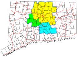
The population of Greater Hartford (as defined by the U.S. Census Bureau), exceeded 1 million in 2000, having a total population of 1,059,878 (2000 census). However, this is the slowest-growing part of Connecticut, having barely grown two percent in the 1990s. The 12% growth in the first half of the 2000s illustrates this trend (2005 population estimate of 1,188,241).
Metropolitan Statistical Area

United States Census Bureau
The United States Census Bureau is the government agency that is responsible for the United States Census. It also gathers other national demographic and economic data...
also defines the Hartford-West Hartford-East Hartford, CT Metropolitan Statistical Area (MSA) based on counties as building blocks. The area contains the 57 towns of Hartford County
Hartford County, Connecticut
Hartford County is a county located in the north central part of the US state of Connecticut. The 2010 Census records show that the county population is at 894,014 making it the second most populated county in Connecticut....
, Tolland County
Tolland County, Connecticut
Tolland County is a county located in the northeastern part of Connecticut. As of 2010, the population was 152,691.Counties in Connecticut have no governmental function: all legal power is vested in the state, city, and town governments...
, and Middlesex County
Middlesex County, Connecticut
Middlesex County is a county located in the south central part of the U.S. state of Connecticut. It was created in 1785 from portions of Hartford and New London counties. As of 2010, the population was 165,676....
. The 2005 population estimate for the MSA is 1,188,241 and is ranked as the 44th largest metropolitan area by population in the United States. While the MSA definition is consistent with national definitions of metropolitan areas, the area contains a significant portion of the Lower Connecticut River Valley
Lower Connecticut River Valley
The Lower Connecticut River Valley is a region of the state of Connecticut focused around the juncture where the Connecticut River meets Long Island Sound. It includes towns in southern Middlesex County and the western edge of New London County...
, which is not commonly considered as part of Greater Hartford.
A region very similar to the MSA is covered by the combination of the Hartford Service Delivery Area and the Mid-Connecticut Service Delivery Area, covering 56 towns.
Transportation
The transportation in Metropolitan Hartford is primarily run by Interstate 84Interstate 84 (east)
Interstate 84 is an Interstate Highway extending from Dunmore, Pennsylvania at an interchange with Interstate 81 to Sturbridge, Massachusetts, at an interchange with the Massachusetts Turnpike . I-84 has mile-log junction numbering in Pennsylvania; otherwise, exit numbers are roughly sequential...
and Interstate 91
Interstate 91
Interstate 91 is an Interstate Highway in the New England region of the United States. It provides the primary north–south thoroughfare in the western part of New England...
. There were several plans to expand the old highway system to be run by 7 interstates (I-91, I-84, I-284, I-291 (full beltway), I-384, I-484, I-491). The existing highway system, due to high population of suburbs and downtown jobs, becomes very heavily congested during rush hours. Other state highways include Connecticut Route 2, Connecticut Route 3, Connecticut Route 9, and Connecticut Route 15.
Public transportation, primarily bus service, is operated by CTTransit. The Connecticut Department of Transportation
Connecticut Department of Transportation
The Connecticut Department of Transportation is responsible for the development and operation of highways, railroads, mass transit systems, ports, waterways and aviation facilities in the U.S. state of Connecticut. The current Commissioner of ConnDOT is Jeffrey Parker...
is located in Newington, Connecticut
Newington, Connecticut
Newington is a town in Hartford County, Connecticut, United States. As of the 2000 census, it had a total population of 29,306. The Connecticut Department of Transportation has its headquarters in Newington....
. The airport is Bradley International Airport
Bradley International Airport
Bradley International Airport is a joint civil-military public airport located in Windsor Locks on the border with East Granby and Suffield, in Hartford County, Connecticut, United States. It is owned by the State of Connecticut....
, located in Windsor Locks, approximately 10 miles from Hartford via I-91. Additional flights are available from Newark International Airport, John F. Kennedy International Airport
John F. Kennedy International Airport
John F. Kennedy International Airport is an international airport located in the borough of Queens in New York City, about southeast of Lower Manhattan. It is the busiest international air passenger gateway to the United States, handling more international traffic than any other airport in North...
and LaGuardia Airport
LaGuardia Airport
LaGuardia Airport is an airport located in the northern part of Queens County on Long Island in the City of New York. The airport is located on the waterfront of Flushing Bay and Bowery Bay, and borders the neighborhoods of Astoria, Jackson Heights and East Elmhurst. The airport was originally...
.
Amtrak
Amtrak
The National Railroad Passenger Corporation, doing business as Amtrak , is a government-owned corporation that was organized on May 1, 1971, to provide intercity passenger train service in the United States. "Amtrak" is a portmanteau of the words "America" and "track". It is headquartered at Union...
runs a daily shuttle between New Haven and Springfield, stopping at Berlin, Windsor, and Windsor Locks, as well as Union Station in Hartford. Commuter rail on the same line is proposed, with rush-hour service centered on Hartford and a shuttle to Bradley International Airport from the Windsor Locks station.