

Great Wold Valley
Encyclopedia
Yorkshire Wolds
The Yorkshire Wolds are low hills in the counties of East Riding of Yorkshire and North Yorkshire in northeastern England. The name also applies to the district in which the hills lie....
. It carries the Gypsey Race, an intermittent stream, which once ran from Wharram-le-Street
Wharram-le-Street
Wharram-le-Street is a village in the Ryedale district of North Yorkshire, England. It is one mile north of the deserted medieval village Wharram Percy. It is mentioned as Warham in the 1086 Domesday Book....
eastwards along and through the northern Yorkshire Wolds to reach the sea at Bridlington
Bridlington
Bridlington is a seaside resort, minor sea fishing port and civil parish on the Holderness Coast of the North Sea, in the East Riding of Yorkshire, England. It has a static population of over 33,000, which rises considerably during the tourist season...
.
It is known that the Great Wold Valley was an important place of worship during Neolithic
Neolithic
The Neolithic Age, Era, or Period, or New Stone Age, was a period in the development of human technology, beginning about 9500 BC in some parts of the Middle East, and later in other parts of the world. It is traditionally considered as the last part of the Stone Age...
times and there are a number of scheduled monuments in the valley. There are two dramatic right angle bends in the course of the Gypsey Race, one turning to the south at Burton Fleming
Burton Fleming
Burton Fleming is a village and civil parish in the East Riding of Yorkshire, England. It lies close to the border with North Yorkshire. The village is situated approximately north west of Bridlington and south of Filey in North Yorkshire....
then another turning eastwards again at Rudston
Rudston
Rudston is a small village and civil parish in the East Riding of Yorkshire, England. It is situated between Driffield and Bridlington approximately to the west of Bridlington, and lies on the B1253 road....
. This intermittent and irregular watercourse is believed to be affected by a siphoning action in underground reservoirs and can come into flood apparently regardless of recent rainfall in the local vicinity. This seemingly magical property is thought to be responsible for the number of significant neolithic sites along its course, including the Rudston Monolith
Rudston Monolith
The Rudston Monolith at over is the tallest megalith in the United Kingdom. It is situated in the churchyard in the village of Rudston in the East Riding of Yorkshire....
and the ancient burial mounds of Willy Howe and Duggleby Howe
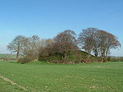
Duggleby Howe
Duggleby Howe is one of thelargest round barrows in Britain, located on thesouthern side of the Great Wold Valley in the district of Ryedale, and isone of four such monuments in this area, known collectively as the...
. Howe, in this case a topographic name from Middle English
Middle English
Middle English is the stage in the history of the English language during the High and Late Middle Ages, or roughly during the four centuries between the late 11th and the late 15th century....
, originated with the Old Norse
Old Norse
Old Norse is a North Germanic language that was spoken by inhabitants of Scandinavia and inhabitants of their overseas settlements during the Viking Age, until about 1300....
word haugr meaning a small hill or a man-made mound or barrow.
Physical influences
The underlying bedrock of the valley is chalk which was laid down in the CretaceousCretaceous
The Cretaceous , derived from the Latin "creta" , usually abbreviated K for its German translation Kreide , is a geologic period and system from circa to million years ago. In the geologic timescale, the Cretaceous follows the Jurassic period and is followed by the Paleogene period of the...
geological period. On the sides of the valley wind blown sand and loess overlay the chalk and in the valley bottom alluvium covers undifferentiated deposits of fragmented chalk which were eroded from the hillsides in the Devensian period of the Ice Age
Ice age
An ice age or, more precisely, glacial age, is a generic geological period of long-term reduction in the temperature of the Earth's surface and atmosphere, resulting in the presence or expansion of continental ice sheets, polar ice sheets and alpine glaciers...
. In pre glacial times the Great Wold Valley was the seaward outlet of the River Ure
River Ure
The River Ure is a river in North Yorkshire, England, approximately long from its source to the point where it changes name to the River Ouse. It is the principal river of Wensleydale, which is the only one of the Dales now named after a village rather than its river...
from Wensleydale
Wensleydale
Wensleydale is the valley of the River Ure on the east side of the Pennines in North Yorkshire, England.Wensleydale lies in the Yorkshire Dales National Park – one of only a few valleys in the Dales not currently named after its principal river , but the older name, "Yoredale", can still be seen...
but the ice sheets in the Vale of York
Vale of York
The Vale of York is an area of flat land in the north-east of England. The vale is a major agricultural area and serves as the main north-south transport corridor for northern England....
blocked and then permanently altered the course of the Ure.
Human influences
Cursus
thumb|right|250px|[[Stonehenge Cursus]], Wiltshirethumb|right|250px|[[Dorset Cursus]] terminal on Thickthorn Down, DorsetCursus was a name given by early British archaeologists such as William Stukeley to the large parallel lengths of banks with external ditches which they thought were early Roman...
converge on the village area. Argham Dyke, a prehistoric earthwork dating from the Bronze Age, crosses the area near Rudston. There is also evidence of Iron Age
Iron Age
The Iron Age is the archaeological period generally occurring after the Bronze Age, marked by the prevalent use of iron. The early period of the age is characterized by the widespread use of iron or steel. The adoption of such material coincided with other changes in society, including differing...
and Romano British occupation as revealed by aerial photographs showing traces of fields, trackways and farms. A Roman villa has been excavated to the south west of Rudston.
The present day field pattern is the result of parliamentary enclosure
Enclosure
Enclosure or inclosure is the process which ends traditional rights such as mowing meadows for hay, or grazing livestock on common land. Once enclosed, these uses of the land become restricted to the owner, and it ceases to be common land. In England and Wales the term is also used for the...
in the 18th and 19th centuries when large areas of common land were enclosed and a new system of land management was introduced. Farmers moved out of the villages onto scattered farmsteads linked to units of land. Nucleated farmsteads usually built of brick with slate or pan tiled roofs were constructed often located on high ground in the rolling farmland. These exposed locations were protected by the planting of shelterbelts of trees. Recreation and tourism enterprises including camping and caravan sites, hotels and fishing lakes, are to be found in the area of the valley close to Bridlington.
Ecological influences
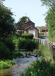
Gypsey springs are watercourses that are intermittent and irregular. They are found all over the Yorkshire Wolds. The Gypsey Race which passes through the Great Wold Valley is the best known of these watercourses. It is a chalk stream which supports large stands of bur-reedSparganium
Sparganium is a genus of flowering plants, containing about 20 species in temperate regions of both the Northern and Southern Hemispheres. It was previously placed alone in the family Sparganiaceae...
. West of Boynton
Boynton, East Riding of Yorkshire
Boynton is a village and civil parish in the East Riding of Yorkshire, England. It is situated approximately west of the town of Bridlington and lies on the B1253 road.According to the 2001 UK census, Boynton parish had a population of 161....
, Boynton Willow Garth SSSI is an example of fen carr with a mosaic of habitats consisting of fen, scrub, woodland and running water. In the more open areas of the lower valley vegetation includes meadowsweet and great willowherb. Under the woodland canopies wood avens and enchanters nightshade are present.
In the upper part of the valley the Gypsey Race begins at Duggleby Howe. This stretch of the valley is broad and flat bottomed with the valley bottom being around 50m above ordnance datum
Ordnance Datum
In the British Isles, an Ordnance Datum or OD is a vertical datum used by an ordnance survey as the basis for deriving altitudes on maps. A spot height may be expressed as AOD for "above ordnance datum". Usually mean sea level is used for the datum...
and the sides rising to 150m above ordnance datum. In places the stream disappears and land use is mainly arable farming with some areas of grassland. Hedgerows form field boundaries and provide wildlife corridors.