
.gif)
Great East Road (Zambia)
Encyclopedia
The Great East Road is a major road in Zambia
and the only highway linking its Eastern Province
with the rest of the country. It is also the major link between Zambia and Malawi
and between Zambia and northern Mozambique
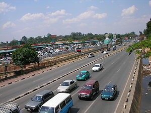
. However, the route does not carry as much traffic as many of the other regional arterial roads and between the main cities it serves, Lusaka
and Chipata
, it passes through rural and wilderness areas. In Lusaka the road forms the main arterial road for the eastern suburbs.
, the capital of the Eastern Province was an early outpost of the British
colonial administration
as Fort Jameson when Zambia was Northern Rhodesia
. Like most of the Eastern Province, it had much easier access to Malawi, then the British protectorate
of Nyasaland
, and to the Mozambique ports of Quelimane
and Beira
than to the rest of Northern Rhodesia, and so most trade and communication in early colonial days was eastwards. Until the mid 1920s mail, goods and passengers went between the capital of the territory at Livingstone
and Fort Jameson by train through neighbouring countries — via Bulawayo
and Beira
to Blantyre
and then by road.
Before the Great East Road, the first direct vehicle access to the east of any kind was a track made in 1929 by transport companies following a more northerly route than the present road, and which crossed both the Lunsemfwa River
and the Luangwa by pontoons made from dugout canoes roped together.
Eventually the Northern Rhodesian authorities needed a better road to assert their control over the Eastern Province, and the first Great East Road was built in 1932 from the Great North Road at the small railway town
of Lusaka
(Livingstone was still the capital, and this junction of the 'Great Roads' together with the main north-south railway contributed to the decision to site the capital in Lusaka in 1935).
 The Eastern Province
is a narrow slice of land sandwiched between Mozambique and Malawi to its south and east, and the Luangwa Valley
, world-famous for its wildlife
, to the north-west, which no highways cross. Apart from a bush track over the highlands in the far north of the province, a narrow neck of land in the west became the only way in from or out to the rest of Zambia, and as the only highway to cross it, the Great East road is strategically vulnerable. This neck is cut by the lower Luangwa River making a turn due south to the Zambezi
, in a narrow and deep valley with steep slopes and thick vegetation, amounting in some sections to a gorge. The river is 250 to 400 m wide in this area, and flows quite fast, with a huge variation according to season.
was built in 1932 with funding from the Beit Trust
. On the eastern side, once the road had climbed up the difficult terrain onto the Luangwa-Zambezi watershed
at Nyimba, Petauke
, and Katete
, the going is easier. Chipata
is reached 605 km from Lusaka and the road goes on to the Malawi
an border 20 km further on, where it connects via Mchinji
to the Malawian capital of Lilongwe
, just 90 km from Chipata.
In addition to its east-west Lusaka-Malawi axis, the Great East Road links north to Lundazi
, north-west to the South Luangwa National Park
, south-east to Mozambique, and, in Lusaka Province
, south to the Lower Zambezi National Park
and the town of Luangwa at the Luangwa-Zambezi river confluence. In the 1960s the Great East road was paved, opening up the Luangwa Valley (and to some extent, Lake Malawi
) to tourism. At times the surface has deteriorated considerably. The section between Katete and the Luangwa Bridge was repaired and reconstructed around 2002/3.
sides in these conflicts, armed incursions cut the road at the Luangwa Bridge
— see that topic for further details.
Zambia
Zambia , officially the Republic of Zambia, is a landlocked country in Southern Africa. The neighbouring countries are the Democratic Republic of the Congo to the north, Tanzania to the north-east, Malawi to the east, Mozambique, Zimbabwe, Botswana and Namibia to the south, and Angola to the west....
and the only highway linking its Eastern Province
Eastern Province, Zambia
Eastern Province is one of Zambia's nine provinces. The province lies between the Luangwa River and the border with Malawi, from Isoka in the northeast to just north of Luangwa in the south.The provincial capital is Chipata...
with the rest of the country. It is also the major link between Zambia and Malawi
Malawi
The Republic of Malawi is a landlocked country in southeast Africa that was formerly known as Nyasaland. It is bordered by Zambia to the northwest, Tanzania to the northeast, and Mozambique on the east, south and west. The country is separated from Tanzania and Mozambique by Lake Malawi. Its size...
and between Zambia and northern Mozambique
Mozambique
Mozambique, officially the Republic of Mozambique , is a country in southeastern Africa bordered by the Indian Ocean to the east, Tanzania to the north, Malawi and Zambia to the northwest, Zimbabwe to the west and Swaziland and South Africa to the southwest...
. However, the route does not carry as much traffic as many of the other regional arterial roads and between the main cities it serves, Lusaka
Lusaka
Lusaka is the capital and largest city of Zambia. It is located in the southern part of the central plateau, at an elevation of about 1,300 metres . It has a population of about 1.7 million . It is a commercial centre as well as the centre of government, and the four main highways of Zambia head...
and Chipata
Chipata
Chipata, population 98,416, is the capital of the Eastern Province of Zambia. The two languages spoken are Nyanja and English, though you might find some Indian languages, as there is a large number of Zambian Indians located in the town...
, it passes through rural and wilderness areas. In Lusaka the road forms the main arterial road for the eastern suburbs.
History
ChipataChipata
Chipata, population 98,416, is the capital of the Eastern Province of Zambia. The two languages spoken are Nyanja and English, though you might find some Indian languages, as there is a large number of Zambian Indians located in the town...
, the capital of the Eastern Province was an early outpost of the British
British Empire
The British Empire comprised the dominions, colonies, protectorates, mandates and other territories ruled or administered by the United Kingdom. It originated with the overseas colonies and trading posts established by England in the late 16th and early 17th centuries. At its height, it was the...
colonial administration
Colonialism
Colonialism is the establishment, maintenance, acquisition and expansion of colonies in one territory by people from another territory. It is a process whereby the metropole claims sovereignty over the colony and the social structure, government, and economics of the colony are changed by...
as Fort Jameson when Zambia was Northern Rhodesia
Northern Rhodesia
Northern Rhodesia was a territory in south central Africa, formed in 1911. It became independent in 1964 as Zambia.It was initially administered under charter by the British South Africa Company and formed by it in 1911 by amalgamating North-Western Rhodesia and North-Eastern Rhodesia...
. Like most of the Eastern Province, it had much easier access to Malawi, then the British protectorate
Protectorate
In history, the term protectorate has two different meanings. In its earliest inception, which has been adopted by modern international law, it is an autonomous territory that is protected diplomatically or militarily against third parties by a stronger state or entity...
of Nyasaland
Nyasaland
Nyasaland or the Nyasaland Protectorate, was a British protectorate located in Africa, which was established in 1907 when the former British Central Africa Protectorate changed its name. Since 1964, it has been known as Malawi....
, and to the Mozambique ports of Quelimane
Quelimane
Quelimane is a seaport in Mozambique. It is the administrative capital of the Zambezia Province and the province's largest city, and stands 25 km from the mouth of the Rio dos Bons Sinais . The river was named when Vasco da Gama, on his way to India, reached it and saw "good signs" that he was on...
and Beira
Beira, Mozambique
Beira is the second largest city in Mozambique. It lies in the central region of the country in Sofala Province, where the Pungue River meets the Indian Ocean. Beira had a population of 412,588 in 1997, which grew to an estimated 546,000 in 2006...
than to the rest of Northern Rhodesia, and so most trade and communication in early colonial days was eastwards. Until the mid 1920s mail, goods and passengers went between the capital of the territory at Livingstone
Livingstone, Zambia
Livingstone or Maramba is a historic colonial city and present capital of the Southern Province of Zambia, a tourism centre for the Victoria Falls lying north of the Zambezi River, and a border town with road and rail connections to Zimbabwe on the other side of the Falls...
and Fort Jameson by train through neighbouring countries — via Bulawayo
Bulawayo
Bulawayo is the second largest city in Zimbabwe after the capital Harare, with an estimated population in 2010 of 2,000,000. It is located in Matabeleland, 439 km southwest of Harare, and is now treated as a separate provincial area from Matabeleland...
and Beira
Beira, Mozambique
Beira is the second largest city in Mozambique. It lies in the central region of the country in Sofala Province, where the Pungue River meets the Indian Ocean. Beira had a population of 412,588 in 1997, which grew to an estimated 546,000 in 2006...
to Blantyre
Blantyre, Malawi
Blantyre or Mandala is Malawi's centre of finance and commerce, the largest city with an estimated 732,518 inhabitants . It is sometimes referred to as the commercial capital of Malawi as opposed to the political capital, Lilongwe...
and then by road.
Before the Great East Road, the first direct vehicle access to the east of any kind was a track made in 1929 by transport companies following a more northerly route than the present road, and which crossed both the Lunsemfwa River
Lunsemfwa River
The Lunsemfwa River is a tributary of the Lukasashi and Luangwa Rivers in Zambia and part of the Zambezi River basin. It is a popular river for fishing, containing large populations of tigerfish and bream....
and the Luangwa by pontoons made from dugout canoes roped together.
Eventually the Northern Rhodesian authorities needed a better road to assert their control over the Eastern Province, and the first Great East Road was built in 1932 from the Great North Road at the small railway town
Railway town
A railway town is a settlement that originated or was greatly developed because of a railway station or junction at its site.In Victorian Britain, the spread of railways greatly affected the fate of many small towns...
of Lusaka
Lusaka
Lusaka is the capital and largest city of Zambia. It is located in the southern part of the central plateau, at an elevation of about 1,300 metres . It has a population of about 1.7 million . It is a commercial centre as well as the centre of government, and the four main highways of Zambia head...
(Livingstone was still the capital, and this junction of the 'Great Roads' together with the main north-south railway contributed to the decision to site the capital in Lusaka in 1935).
Route geography
Eastern Province, Zambia
Eastern Province is one of Zambia's nine provinces. The province lies between the Luangwa River and the border with Malawi, from Isoka in the northeast to just north of Luangwa in the south.The provincial capital is Chipata...
is a narrow slice of land sandwiched between Mozambique and Malawi to its south and east, and the Luangwa Valley
Luangwa River
The Luangwa River is one of the major tributaries of the Zambezi River, and one of the four biggest rivers of Zambia. The river generally floods in the rainy season and then falls considerably in the dry season...
, world-famous for its wildlife
South Luangwa National Park
South Luangwa National Park in eastern Zambia, the southernmost of three national parks in the valley of the Luangwa River, is a world-renowned wildlife haven. It supports large populations of Thornicroft's Giraffe, and herds of elephant and buffalo often several hundred strong, while the Luangwa...
, to the north-west, which no highways cross. Apart from a bush track over the highlands in the far north of the province, a narrow neck of land in the west became the only way in from or out to the rest of Zambia, and as the only highway to cross it, the Great East road is strategically vulnerable. This neck is cut by the lower Luangwa River making a turn due south to the Zambezi
Zambezi
The Zambezi is the fourth-longest river in Africa, and the largest flowing into the Indian Ocean from Africa. The area of its basin is , slightly less than half that of the Nile...
, in a narrow and deep valley with steep slopes and thick vegetation, amounting in some sections to a gorge. The river is 250 to 400 m wide in this area, and flows quite fast, with a huge variation according to season.
The route and its branches
Crossing the steep terrain of the lower Luangwa valley was a major challenge. The 1929 track was usually closed in the rainy season, and so the first Luangwa BridgeLuangwa Bridge
The Luangwa Bridge is the only large bridge and the principal engineering challenge on Zambia's Great East Road, crossing the lower Luangwa River where it flows from the Luangwa Rift Valley into the Zambezi valley....
was built in 1932 with funding from the Beit Trust
Alfred Beit
Alfred Beit was a German, British South African, Jewish gold and diamond magnate, a supporter of British imperialism in Southern Africa and a major donor towards infrastructure development in central and Southern Africa, and to university education and research in several countries.- Life and...
. On the eastern side, once the road had climbed up the difficult terrain onto the Luangwa-Zambezi watershed
Water divide
A drainage divide, water divide, divide or watershed is the line separating neighbouring drainage basins...
at Nyimba, Petauke
Petauke
Petauke is a town and seat of Petauke District located in the Eastern Province of Zambia.Petauke is 400 km from the capital city Lusaka, roughly halfway between Lusaka and the Malawi border...
, and Katete
Katete
Katete is a small town in the Eastern Province of Zambia, and is headquarters of Katete District. The town is at the foot of rocky hills which lie to its east, including Mpangwe Hill and Kangarema Hill, which rise to 1600 m and are surrounded by cultivated fields...
, the going is easier. Chipata
Chipata
Chipata, population 98,416, is the capital of the Eastern Province of Zambia. The two languages spoken are Nyanja and English, though you might find some Indian languages, as there is a large number of Zambian Indians located in the town...
is reached 605 km from Lusaka and the road goes on to the Malawi
Malawi
The Republic of Malawi is a landlocked country in southeast Africa that was formerly known as Nyasaland. It is bordered by Zambia to the northwest, Tanzania to the northeast, and Mozambique on the east, south and west. The country is separated from Tanzania and Mozambique by Lake Malawi. Its size...
an border 20 km further on, where it connects via Mchinji
Mchinji
Mchinji is a town in the Mchinji District of the Central Region of Malawi. As of 2008 estimates, Mchinji has a population of 25,184. The area's economy is sustained by rain-fed agriculture, although the town is currently in the midst of a food crisis. Mchinji is also a major railroad junction,...
to the Malawian capital of Lilongwe
Lilongwe
Lilongwe, estimated population 902,388 as of 2009, is the capital and largest city of Malawi. It lies in the country's central region, on the Lilongwe River, near the border of Malawi, Mozambique, and Zambia, and on the main north-south highway of Malawi, the M1.-History:The city started life as a...
, just 90 km from Chipata.
In addition to its east-west Lusaka-Malawi axis, the Great East Road links north to Lundazi
Lundazi
Lundazi is a town in eastern Zambia, lying near the border with Malawi, around 110 miles from Chipata. It is home to an airstrip, schools and a hotel in the form of a Norman castle. The building of the castle was begun in 1948 by an Englishman called Errol Buton, who reputedly sketched out its...
, north-west to the South Luangwa National Park
South Luangwa National Park
South Luangwa National Park in eastern Zambia, the southernmost of three national parks in the valley of the Luangwa River, is a world-renowned wildlife haven. It supports large populations of Thornicroft's Giraffe, and herds of elephant and buffalo often several hundred strong, while the Luangwa...
, south-east to Mozambique, and, in Lusaka Province
Lusaka Province
Lusaka Province is one of Zambia's nine provinces. The provincial capital is Lusaka, which is also the national capital.-National Parks and wildlife areas:*Lower Zambezi National Park...
, south to the Lower Zambezi National Park
Lower Zambezi National Park
The Lower Zambezi National Park lies on the north bank of the Zambezi River in south eastern Zambia. Until 1983 when the area was declared a national park the area was the private game reserve of Zambia's president. This has resulted in the park being protected from the ravages of mass tourism and...
and the town of Luangwa at the Luangwa-Zambezi river confluence. In the 1960s the Great East road was paved, opening up the Luangwa Valley (and to some extent, Lake Malawi
Lake Malawi
Lake Malawi , is an African Great Lake and the southernmost lake in the Great Rift Valley system of East Africa. This lake, the third largest in Africa and the eighth largest lake in the world, is located between Malawi, Mozambique, and Tanzania...
) to tourism. At times the surface has deteriorated considerably. The section between Katete and the Luangwa Bridge was repaired and reconstructed around 2002/3.
Strategic significance
As well as being strategically vulnerable as described above, the Great East Road is within a few kilometres of Mozambique and a few tens of kilometres of Zimbabwe, where there were wars of independence in the 1960s and 1970s. As a result of Zambia's political support for the anti-apartheid and independenceAfrican independence movements
The African Independence Movements took place in the 20th century, when a wave of struggles for independence in European-ruled African territories were witnessed....
sides in these conflicts, armed incursions cut the road at the Luangwa Bridge
Luangwa Bridge
The Luangwa Bridge is the only large bridge and the principal engineering challenge on Zambia's Great East Road, crossing the lower Luangwa River where it flows from the Luangwa Rift Valley into the Zambezi valley....
— see that topic for further details.