
Grapevine Lake
Encyclopedia
Grapevine Lake is a freshwater lake
located in the north Texas
area, approximately 20 mi (32 km) northwest of Dallas, Texas
. It was impounded in 1952 by the US Army Corps of Engineers when they dammed Denton Creek. The lake's primary purposes are flood control and to act as a water reservoir
, with a secondary function of providing recreation and natural land area. The lake's name comes from the city of Grapevine, Texas
, to which the lake is adjacent.
. All the projects were for the purposes of both flood control and navigation. These lakes became part of an extensive floodway system that is operated in a coordinated manner to minimize flooding along the Trinity river
floodplain.
The Grapevine Dam and Reservoir project, as it was originally known, was initiated in January 1948. Located on Denton Creek, a tributary of the Elm Fork of the Trinity river, the project spans both Tarrant County
and Denton County
. In this area immediately north of the City of Grapevine
, the Corps of Engineers obtained approximately 15,700 acres (63.5 km²) of land and placed easements on another 2,200 acres (8.9 km²) to be flooded by the new reservoir. The project was completed in June 1952, and impounding of water began July 3, 1952.
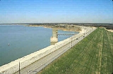
type, 28 feet (8.5 m) thick, which spans 12,850 feet (3,920 m). The crest of the dam is located at 588 feet (179 m) above sea level. At the dam, the original creek bed was at 451 feet (137 m), making the dam approximately 137 ft (42 m) tall.
The dam's spillway
is located at approximately 560 feet (170.7 m) above sea level. This gives it a flood capacity of at least 425500 acre.ft, including an allowance for the build of up sediment in the lake's bottom. Typically, the lake is maintained near its conservation level, at 535 ft (163 m), giving it a capacity of 181100 acre.ft and a surface area of 7,280 acres (29.5 km²).
At conservation level, the lake has approximately 60 mi (97 km) of shoreline.
.
Under its September 1953 contract, Grapevine obtained 1250 acre.ft of the water in the elevations between 500 and 535 feet (152 and 163 m) above sea-level. In February 1981, the city obtained an additional 25000 acre.ft in the same elevations "until such time as this [water] is needed for navigation purposes." In March 1953, the city of Dallas obtained 85000 acre.ft of the water between 500 and 535 feet (152 and 163 m), and in March 1955, DCPC obtained 50000 acre.ft at the same elevations.
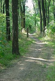
Trails listed by the Corps of Engineers include the nine mile (14 km) Northshore trail, the three mile (5 km) Rocky Point trail, the five mile (8 km) Crosstimbers horse trail, and the four mile (6 km) Knob Hill trail.
s located on the lake, all operated by the private company Marinas International. On the south shore, in Grapevine, are Scott's Landing and Silver Lake. On the north shore, in Flower Mound
, is Twin Coves. The marinas support an active boating community on the lake; combined, the three marinas have approximately 1,400 moorings, with land-based storage for an additional 575 vessels.
Both the Grapevine Sailing Club and the United States Coast Guard Auxiliary
(Flotilla 5-11 of District 8) are based at Scott's Landing.
Ten boat ramps provide access to the lake, of which only the two ramps at Murrell park are controlled by the Corps of Engineers and available for free. Of the remaining ramps:
The lake is also utilized by amphibious vehicle
-based tour companies.
, spotted bass
, white bass
, white crappie, and channel catfish
. Fishing regulations of most species are managed under statewide regulations. The exception is a 14 to 18 inch (36 to 46 cm) slot limit on largemouth bass; only bass 14 inches (36 cm) and less in length, or 18 inches (46 cm) or more, may be retained. Daily bag limit for all species of black bass is 5 in any combination. Murrell Park, a premier spot for catching sand and black bass on the north shore, was heavily damaged in the summer 2007 flood and was partially closed.
With a permit
and in season, public hunting is allowed in the Trophy Club Park area (formerly Marshall Creek Park), located at the north-west end of the lake. Waterfowl
and small game hunting, as well as bow hunting of feral hogs and deer
is permitted. Hunting licenses are obtained from the state of Texas and an additional permit from the U.S. Army Corps of Engineers required.
On March 24, 2010, Kris Howe found four bones of a 96 million year old bird. Two Dallas
scientists say that the bird is the oldest in America.
Information
Lake
A lake is a body of relatively still fresh or salt water of considerable size, localized in a basin, that is surrounded by land. Lakes are inland and not part of the ocean and therefore are distinct from lagoons, and are larger and deeper than ponds. Lakes can be contrasted with rivers or streams,...
located in the north Texas
North Texas
North Texas is a distinct cultural and geographic area forming the central-northeastern section of the U.S. state of Texas. North Texas is generally considered to include the area south of Oklahoma, east of Abilene, and north of Waco...
area, approximately 20 mi (32 km) northwest of Dallas, Texas
Dallas, Texas
Dallas is the third-largest city in Texas and the ninth-largest in the United States. The Dallas-Fort Worth Metroplex is the largest metropolitan area in the South and fourth-largest metropolitan area in the United States...
. It was impounded in 1952 by the US Army Corps of Engineers when they dammed Denton Creek. The lake's primary purposes are flood control and to act as a water reservoir
Reservoir
A reservoir , artificial lake or dam is used to store water.Reservoirs may be created in river valleys by the construction of a dam or may be built by excavation in the ground or by conventional construction techniques such as brickwork or cast concrete.The term reservoir may also be used to...
, with a secondary function of providing recreation and natural land area. The lake's name comes from the city of Grapevine, Texas
Grapevine, Texas
Grapevine is a city in northeast Tarrant County, Texas, United States located within the Dallas-Fort Worth metropolitan area. As of the 2010 census the city population was 46,334. The city's moniker is derived from the native grapes prevalent in the area. In recent years several wineries have...
, to which the lake is adjacent.
History and construction
On March 2, 1945, the U.S. Congress approved the River & Harbors Act of 1945 which, among many projects, provided for the construction of Benbrook Lake, Grapevine Lake, Lavon Lake and Ray Roberts Lake, as well as modifications to the existing Garza Dam for the construction of Lewisville LakeLewisville Lake
Lewisville Lake is a reservoir located in North Texas on the Elm Fork of the Trinity River in Denton County near Lewisville. The lake is primarily used recreationally for boating and watercraft, however, it was built for flood control purposes and to serve as a water source for Dallas and its...
. All the projects were for the purposes of both flood control and navigation. These lakes became part of an extensive floodway system that is operated in a coordinated manner to minimize flooding along the Trinity river
Trinity River (Texas)
The Trinity River is a long river that flows entirely within the U.S. state of Texas. It rises in extreme north Texas, a few miles south of the Red River. The headwaters are separated by the high bluffs on the south side of the Red River....
floodplain.
The Grapevine Dam and Reservoir project, as it was originally known, was initiated in January 1948. Located on Denton Creek, a tributary of the Elm Fork of the Trinity river, the project spans both Tarrant County
Tarrant County, Texas
Tarrant County is a county located in the U.S. state of Texas. As of the 2010 U.S. Census, it had a population of 1,809,034. Its county seat is Fort Worth. Tarrant County is the sixteenth most populous county in the United States and the third most populous in Texas. The county is named in honor...
and Denton County
Denton County, Texas
Denton County is a county located in the U.S. state of Texas. In 2000, its population was 432,976; in 2009 the estimated population had reached 628,300. Part of the Dallas – Fort Worth Metroplex, it is one of the fastest-growing counties in the United States. The county seat is Denton. The county...
. In this area immediately north of the City of Grapevine
Grapevine, Texas
Grapevine is a city in northeast Tarrant County, Texas, United States located within the Dallas-Fort Worth metropolitan area. As of the 2010 census the city population was 46,334. The city's moniker is derived from the native grapes prevalent in the area. In recent years several wineries have...
, the Corps of Engineers obtained approximately 15,700 acres (63.5 km²) of land and placed easements on another 2,200 acres (8.9 km²) to be flooded by the new reservoir. The project was completed in June 1952, and impounding of water began July 3, 1952.
Statistics
The dam is a rolled earth-fillEmbankment dam
An embankment dam is a massive artificial water barrier. It is typically created by the emplacement and compaction of a complex semi-plastic mound of various compositions of soil, sand, clay and/or rock. It has a semi-permanent waterproof natural covering for its surface, and a dense, waterproof...
type, 28 feet (8.5 m) thick, which spans 12,850 feet (3,920 m). The crest of the dam is located at 588 feet (179 m) above sea level. At the dam, the original creek bed was at 451 feet (137 m), making the dam approximately 137 ft (42 m) tall.
The dam's spillway
Spillway
A spillway is a structure used to provide the controlled release of flows from a dam or levee into a downstream area, typically being the river that was dammed. In the UK they may be known as overflow channels. Spillways release floods so that the water does not overtop and damage or even destroy...
is located at approximately 560 feet (170.7 m) above sea level. This gives it a flood capacity of at least 425500 acre.ft, including an allowance for the build of up sediment in the lake's bottom. Typically, the lake is maintained near its conservation level, at 535 ft (163 m), giving it a capacity of 181100 acre.ft and a surface area of 7,280 acres (29.5 km²).
At conservation level, the lake has approximately 60 mi (97 km) of shoreline.
Water rights
Three municipalities have water rights to the lake; the city of Grapevine, the city of Dallas, and the Dallas County Park Cities (DCPC), which provides water to various communities in Dallas CountyDallas County, Texas
As of the census of 2000, there were 2,218,899 people, 807,621 households, and 533,837 families residing in the county. The population density was 2,523 people per square mile . There were 854,119 housing units at an average density of 971/sq mi...
.
Under its September 1953 contract, Grapevine obtained 1250 acre.ft of the water in the elevations between 500 and 535 feet (152 and 163 m) above sea-level. In February 1981, the city obtained an additional 25000 acre.ft in the same elevations "until such time as this [water] is needed for navigation purposes." In March 1953, the city of Dallas obtained 85000 acre.ft of the water between 500 and 535 feet (152 and 163 m), and in March 1955, DCPC obtained 50000 acre.ft at the same elevations.
Recreation
 |
 |
Parks and trails
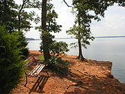
Numerous parks surround the lake. Some of the parks are owned, leased or maintained by the local community. Others remain in the Corp of Engineer's control. The area contains 30 miles (50 km) of natural surface trails including nature, biking and equestrian trails.Trails listed by the Corps of Engineers include the nine mile (14 km) Northshore trail, the three mile (5 km) Rocky Point trail, the five mile (8 km) Crosstimbers horse trail, and the four mile (6 km) Knob Hill trail.
Camping
The lake has primitive camping, prepared camping sites, and trailer / RV camping. Murrell park currently has tent and primitive camping, but is undergoing an expansion to increase camping facilities. Vineyards campground, managed by the city of Grapevine, offers site camping, RV parking, and cabins.Marinas and boating
There are three marinaMarina
A marina is a dock or basin with moorings and supplies for yachts and small boats.A marina differs from a port in that a marina does not handle large passenger ships or cargo from freighters....
s located on the lake, all operated by the private company Marinas International. On the south shore, in Grapevine, are Scott's Landing and Silver Lake. On the north shore, in Flower Mound
Flower Mound, Texas
Flower Mound is a town in Denton and Tarrant counties in the U.S. state of Texas, and a suburb of Fort Worth and Dallas. Its population was 50,702 at the U.S. Census Bureau's 2000 census, and 64,669 at the 2010 Census. The town derives its name from the prominent mound located in the southern...
, is Twin Coves. The marinas support an active boating community on the lake; combined, the three marinas have approximately 1,400 moorings, with land-based storage for an additional 575 vessels.
Both the Grapevine Sailing Club and the United States Coast Guard Auxiliary
United States Coast Guard Auxiliary
The United States Coast Guard Auxiliary is the uniformed volunteer component of the United States Coast Guard and was established on June 23, 1939 by an act of Congress as the United States Coast Guard Reserve, and was re-designated as the United States Coast Guard Auxiliary on February 19, 1941...
(Flotilla 5-11 of District 8) are based at Scott's Landing.
Ten boat ramps provide access to the lake, of which only the two ramps at Murrell park are controlled by the Corps of Engineers and available for free. Of the remaining ramps:
- The City of Trophy ClubTrophy Club, TexasTrophy Club is an affluent town located in Denton and Tarrant Counties in the U.S. state of Texas. It is a wealthy northern suburb of the city of Fort Worth and is part of the Dallas-Fort Worth Metroplex. The population was 8,024 at the 2010 Census...
operates Trophy Club Park which includes a ramp (formerly Marshall Creek park). - The City of Grapevine operates public fee-based ramps at Meadowmere, Lakeview, Oak Grove, and Katie's Woods parks.
- The private company Marinas International operates a fee-based ramp at Silver Lake Marina.
The lake is also utilized by amphibious vehicle
Amphibious vehicle
An amphibious vehicle , is a vehicle or craft, that is a means of transport, viable on land as well as on water – just like an amphibian....
-based tour companies.
Fishing and hunting
The lake is home to a number of fish species, including largemouth bassLargemouth bass
The largemouth bass is a species of black bass in the sunfish family native to North America . It is also known as widemouth bass, bigmouth, black bass, bucketmouth, Potter's fish, Florida bass, Florida largemouth, green bass, green trout, linesides, Oswego bass, southern largemouth...
, spotted bass
Spotted bass
The Spotted Bass , also called "Spotty", "Leeman", or "Spots" in various fishing communities, is a species of freshwater fish sunfish family of order Perciformes. One of the black basses, it is native to the Mississippi River basin and across theGulf States, from central Texas through the Florida...
, white bass
White bass
The white bass or sand bass The white bass or sand bass The white bass or sand bass (MoroneIt is the state fish of Oklahoma.- Range :White bass are distributed widely across the United States, particularly in the midwest. They are very abundant in Pennsylvania and the area around Lake Erie...
, white crappie, and channel catfish
Catfish
Catfishes are a diverse group of ray-finned fish. Named for their prominent barbels, which resemble a cat's whiskers, catfish range in size and behavior from the heaviest and longest, the Mekong giant catfish from Southeast Asia and the second longest, the wels catfish of Eurasia, to detritivores...
. Fishing regulations of most species are managed under statewide regulations. The exception is a 14 to 18 inch (36 to 46 cm) slot limit on largemouth bass; only bass 14 inches (36 cm) and less in length, or 18 inches (46 cm) or more, may be retained. Daily bag limit for all species of black bass is 5 in any combination. Murrell Park, a premier spot for catching sand and black bass on the north shore, was heavily damaged in the summer 2007 flood and was partially closed.
With a permit
Hunting license
A hunting license is a regulatory or legal mechanism to control recreational and sports hunting.Hunting may be regulated informally by "unwritten law", "self restraint", or "morality" and by laws "enforced by government authority."...
and in season, public hunting is allowed in the Trophy Club Park area (formerly Marshall Creek Park), located at the north-west end of the lake. Waterfowl
Waterfowl
Waterfowl are certain wildfowl of the order Anseriformes, especially members of the family Anatidae, which includes ducks, geese, and swans....
and small game hunting, as well as bow hunting of feral hogs and deer
Deer
Deer are the ruminant mammals forming the family Cervidae. Species in the Cervidae family include white-tailed deer, elk, moose, red deer, reindeer, fallow deer, roe deer and chital. Male deer of all species and female reindeer grow and shed new antlers each year...
is permitted. Hunting licenses are obtained from the state of Texas and an additional permit from the U.S. Army Corps of Engineers required.
On March 24, 2010, Kris Howe found four bones of a 96 million year old bird. Two Dallas
Dallas, Texas
Dallas is the third-largest city in Texas and the ninth-largest in the United States. The Dallas-Fort Worth Metroplex is the largest metropolitan area in the South and fourth-largest metropolitan area in the United States...
scientists say that the bird is the oldest in America.
Adjacency to Dallas Fort Worth International Airport (DFW)
Grapevine Lake borders Dallas/Fort Worth International Airport to the northwest, making it a major landmark to persons flying into or out of that airport. Many of its features, such as its parks, marinas, and dam, are visible in great detail to the airline passengers upon takeoff or landing.See also
- Lake Lewisville
- Lake Ray RobertsLake Ray RobertsLake Ray Roberts is a reservoir located north of Denton, Texas, between the cities of Pilot Point, Texas and Sanger, Texas.. It was named after Ray Roberts in 1980....
- Trinity River AuthorityTrinity River AuthorityThe Trinity River Authority or TRA was formed in 1955 by the Texas legislature. Its main concerns are water supply and water conservation in the Trinity River Basin. The authority extends over , including all or part of 17 counties...
External links
Maps- Corps of Engineers' map of Grapevine lake and parks
- Corps of Engineers' map of Northshore Trail
Information
- Elm Fork Project office of the Corps of Engineer's Grapevine Lake page
- Grapevine lake water level - database of daily lake levels from mid-1970s to current.
- Texas Parks and Wildlife's site about fishing Grapevine Lake
- Guide to Texas Outside's review of Grapevine lake
- Sailing Texas's visit to Grapevine lake
- US Coast Guard Auxiliary Flotilla 5-11 District 8, based at Scott's Landing
- Grapevine sailing club, based at Scott's Landing
- Buoys on the Lake at Twin Coves Marina