

Grande Raccordo Anulare
Encyclopedia
Rome
Rome is the capital of Italy and the country's largest and most populated city and comune, with over 2.7 million residents in . The city is located in the central-western portion of the Italian Peninsula, on the Tiber River within the Lazio region of Italy.Rome's history spans two and a half...
. Its acronym was given after one of its main designers and supporters, Eugenio Gra, chairman of ANAS
ANAS
ANAS S.p.A. is an Italian government-owned company deputed to the construction and maintenance of Italian motorways and state highways under the control of Italian Ministry of Infrastructure and Transport.-History:Founded on June 27, 1946, the company took immediately a government granting for the...
, the Italian roads Authority, at the time of construction.
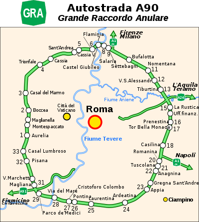
The official number among the Italian motorways is A90, although barely known and not found anywhere on road signs. It's widely known by Romans as Il Raccordo ("The Ring Road").
History
Foundamental GRA History1948: Building works begin
1951: Appia-Aurelia section is opened
1952: Flaminia-Tiburtina section is opened
1955: Tiburtina-Appia section is opened
1960: 1960 Summer Olympics
1960 Summer Olympics
The 1960 Summer Olympics, officially known as the Games of the XVII Olympiad, was an international multi-sport event held from August 25 to September 11, 1960 in Rome, Italy...
- road was part of the marathon
Athletics at the 1960 Summer Olympics
At the 1960 Summer Olympics in Rome, 34 events in athletics were contested, 24 by men and 10 by women. There were a total number of 1016 participating athletes from 73 countries.-Men's events:-Women's events:-Medal table:-Records broken:...
course.
1962: Lane number is doubled, in Salaria-Tuscolana section
1970: Aurelia-Flaminia section is opened, the ring is completed.
1979: GRA is now officially a highway
1983: Works to a 6-lane set begin
1997: 50% of the GRA track is on a 6-lane (2x3) set
2000: 75% of the GRA track is on a 6-lane set
2007: 97% of the GRA track is on a 6-lane set
2011: End of works to the 6-lane set
Plans for an orbital road around Rome were proposed by the end of the World War II
World War II
World War II, or the Second World War , was a global conflict lasting from 1939 to 1945, involving most of the world's nations—including all of the great powers—eventually forming two opposing military alliances: the Allies and the Axis...
. One of the designers' main purposes was to build the road as most equally distant as possible from the geographic centre of town, the Campidoglio, 11,4 km (7 mi) away from the motorway.
Construction works started in 1948. The first section, Flaminia
Via Flaminia
The Via Flaminia was an ancient Roman road leading from Rome over the Apennine Mountains to Ariminum on the coast of the Adriatic Sea, and due to the ruggedness of the mountains was the major option the Romans had for travel between Etruria, Latium and Campania and the Po Valley...
to Tiburtina
Via Tiburtina
Via Tiburtina is an ancient road in Italy leading east-northeast from Rome to Tivoli . It was built by the Roman consul Marcus Valerius Maximus around 286 BC and later lengthened to the territories of the Marsi and the Equi, in the Abruzzo, as Via Valeria. Its total length was approximately...
(north-to-east section) opened in 1952, later extended in stages. The last section to be opened was the west-to-north section (Aurelia
Via Aurelia
The Via Aurelia was a Roman road in Italy constructed around the year 241 BC. The project was undertaken by C. Aurelius Cotta, who at that time was censor...
to Flaminia), in 1970.
Although the GRA was initially planned and built as a single-carriageway road, it was soon clear that traffic was rapidly growing well beyond the expectations. Upgrade works to motorway standards started in late 1950s with first dual-carriageway, four-lane section (Salaria to Tuscolana) opened 1962. Further works were carried over throughout the 1970s, and by 1979 the remainder sections were upgraded to four-lane and the entire ring classified as toll-free highway.
Upgrade works to 6-lane started in 1983 and were completed in stages throughout the 1990s and 2000s. As of April 2008 97% of the GRA was 6-lane with final sections (new tunnel under Via Cassia
Via Cassia
The Via Cassia was an important Roman road striking out of the Via Flaminia near the Milvian Bridge in the immediate vicinity of Rome and, passing not far from Veii traversed Etruria...
) opened 2011.
GRA now
As of 2011, GRA is one of the most important roads in RomeRome
Rome is the capital of Italy and the country's largest and most populated city and comune, with over 2.7 million residents in . The city is located in the central-western portion of the Italian Peninsula, on the Tiber River within the Lazio region of Italy.Rome's history spans two and a half...
, and traffic reaches 160.000 vehicles per day, and maintenance costs are around 11 million euros per year.
GRA features 14 tunnels, with lengths varying from the 66 meters of Parco di Veio II tunnel to the 1150 meters of the Appia Antica tunnel and 8 rest areas.
GRA has 42 junctions, with Via Aurelia being numbered as 1 and other following clockwise. Actually, Romans refer to every junction with the name of street that it crosses.
Thought it is officially a highway, GRA never had a road toll, although there are plans, albeit not yet in place as of August 2011, to introduce a fee for vehicles entering the GRA from Highways.
A New GRA?
It has been suggested that a second ring might be constructed in the future, firstly as an attempt to alleviate congestion on the old one and secondly to offer access to a number of new industrial, commercial and residential zones built around it.Such a project would imply a new external ring-shaped orbital motorway of about 120 kilometres (74.6 mi), denominated NIA (Nuova infrastruttura anulare, "New ring infrastructure"), which would cost over €5 billion.
See also
- Périphérique (Paris)Périphérique (Paris)Boulevard Périphérique is a controlled-access dual-carriageway ring road in Paris, France. One of the busiest highways in Europe, the Périphérique is the generally-accepted boundary between the city proper of Paris and its suburbs...
- M25 motorwayM25 motorwayThe M25 motorway, or London Orbital, is a orbital motorway that almost encircles Greater London, England, in the United Kingdom. The motorway was first mooted early in the 20th century. A few sections, based on the now abandoned London Ringways plan, were constructed in the early 1970s and it ...
(LondonLondonLondon is the capital city of :England and the :United Kingdom, the largest metropolitan area in the United Kingdom, and the largest urban zone in the European Union by most measures. Located on the River Thames, London has been a major settlement for two millennia, its history going back to its...
) - M30 motorway (MadridMadridMadrid is the capital and largest city of Spain. The population of the city is roughly 3.3 million and the entire population of the Madrid metropolitan area is calculated to be 6.271 million. It is the third largest city in the European Union, after London and Berlin, and its metropolitan...
) - Capital BeltwayInterstate 495 (Capital Beltway)Interstate 495 is a Interstate Highway that surrounds the United States' capital of Washington, D.C., and its inner suburbs in adjacent Maryland and Virginia. I-495 is widely known as the Capital Beltway or simply the Beltway, especially when the context of Washington, D.C., is clear...
(Washington, DC) - Highway 407 ETR (TorontoTorontoToronto is the provincial capital of Ontario and the largest city in Canada. It is located in Southern Ontario on the northwestern shore of Lake Ontario. A relatively modern city, Toronto's history dates back to the late-18th century, when its land was first purchased by the British monarchy from...
) - MKADMKADMKAD is a ring road encircling the City of Moscow.The acronym is a transliteration of the Russian МКАД, for Московская Кольцевая Автомобильная Дорога .The growth of traffic in and around Moscow in the 1950s made the city planners realise Russia's largest metropolis...
(MoscowMoscowMoscow is the capital, the most populous city, and the most populous federal subject of Russia. The city is a major political, economic, cultural, scientific, religious, financial, educational, and transportation centre of Russia and the continent...
)