

Périphérique (Paris)
Encyclopedia
Ring road
A ring road, orbital motorway, beltway, circumferential highway, or loop highway is a road that encircles a town or city...
in Paris
Paris
Paris is the capital and largest city in France, situated on the river Seine, in northern France, at the heart of the Île-de-France region...
, France
France
The French Republic , The French Republic , The French Republic , (commonly known as France , is a unitary semi-presidential republic in Western Europe with several overseas territories and islands located on other continents and in the Indian, Pacific, and Atlantic oceans. Metropolitan France...
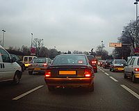
. One of the busiest highways in Europe, the Périphérique is the generally-accepted boundary between the city proper of Paris and its suburbs. Save for a few exceptions (see Structure and Layout), it is situated along Paris's administrative limit.
The speed limit is 80 km/h (50 mph). Each ring, or loop, generally provides four traffic lanes, and does not feature a hard shoulder. Due to the road's legal status, circulating traffic yields priority to entering vehicles.
When traveling at the legal speed limit, it takes around 26 minutes to complete a full circuit.
History
Construction of the Périphérique was begun in 1958 on the former site of the Thiers WallThiers wall
The Thiers wall was the last of the defensive walls of Paris. It was an enclosure constructed between 1841 and 1844 under a law enacted by the government of the French prime minister, Adolphe Thiers. It covered , along the 'boulevards des Maréchaux' of today...
(the last remaining of the City walls of Paris
City walls of Paris
Over time, several city walls of Paris were built :* a gauloise enclosure * a Gallo-Roman wall* two medieval walls including the main one : the wall of Philippe Auguste* the wall of Charles V, extending on the right bank...
). Destruction of this obsolete structure in the 1920s left a clear ring of vacant land surrounding Paris, which at first was claimed by slums and squatters. In order to alleviate traffic congestion, the Boulevard was planned along this abandoned land, and completed on 25 April 1973 under the presidency of Georges Pompidou
Georges Pompidou
Georges Jean Raymond Pompidou was a French politician. He was Prime Minister of France from 1962 to 1968, holding the longest tenure in this position, and later President of the French Republic from 1969 until his death in 1974.-Biography:...
. Providing a route for a quarter of all Parisian traffic movements, it quickly became the busiest road in France. However it became a victim of its own success with widespread congestion, while the dense urban area surrounding it prevents its expansion.
Noise reducing covers for the Périphérique are included in the 2000-2006 State-region Plan for three sections: Porte des Lilas, Porte de Vanves and the section from Porte des Ternes to Porte de Champerret. To date, the covers of Porte des Lilas and Porte de Vanves are complete but construction for Porte de Champerret has not yet begun.
Périphérique intérieur vs. extérieur
The Périphérique consists of two concentric carriageways: the intérieur ("inner ring") and the extérieur ("outer ring"). Vehicles travel clockwise on the inner ring and anticlockwise on the outer ring. Some stretches of the road are sometimes referred to by cardinal direction. For example, in the southern half of the highway, the "inner ring" is designated as the Périphérique Ouest ("Western Ring") as traffic flows westbound whereas the "outer ring" is designated as the Périphérique Est ("Eastern Ring") as traffic flows eastbound. In the northern half, these designations are reversed, respectively as the highway is circular.Structure and layout
The structure of the Boulevard Périphérique is similar to most French autorouteAutoroutes of France
The Autoroute system in France consists largely of toll roads, except around large cities and in parts of the north. It is a network of worth of motorways. Autoroute destinations are shown in blue, while destinations reached through a combination of autoroutes are shown with an added autoroute logo...
s, U.K. and Commonwealth nation motorways, and North American freeways in the following regards:
- It is a two-ring, multiple-lane controlled access road with no at-grade crossings or traffic lights. Maximum longitudinal slope is 4%.
- Traffic headed in opposite directions (each ring) is separated by a central reservationCentral reservationOn divided roads, such as divided highways or freeways/motorways, the central reservation , median, parkway , median strip or central nature strip is the area which separates opposing lanes of traffic...
(British English), also known as a medianMedianIn probability theory and statistics, a median is described as the numerical value separating the higher half of a sample, a population, or a probability distribution, from the lower half. The median of a finite list of numbers can be found by arranging all the observations from lowest value to...
(North American and Australian English).
The Boulevard Périphérique also retains some peculiar differences:
- The "priorité à droite" applies: Motorists entering the right-hand lane have the right-of-way, i.e. priority over vehicles already in circulation in the ring road. This stems from the traditional rules governing Parisian boulevards.
- To ensure safety and fluidity of movement in regard to the above difference, the right-hand lane is exclusively reserved for vehicles entering or preparing to leave the "normal" movement of vehicles in the other lanes, or the Boulevard itself. A solid white line separates the recently entered traffic and the circulating traffic. This is done to prevent entering from disrupting the flow of circulating traffic in the inner lanes, as without the line any traffic must yield to any entering traffic across all lanes.
- There is the absence of a shoulderShoulder (road)A hard shoulder, or simply shoulder, is a reserved area by the verge of a road or motorway. Generally it is kept clear of motor vehicle traffic...
(emergency lane). The Boulevard does not incorporate one along almost all of its route, except around the Porte de Gentilly. This means that accidents can cause considerable disruption to the traffic, and because of this emergency services also have difficulty getting to the scene of the accident.
There are generally four lanes in each of the two rings of the Boulevard. Notable variations exist:
- A two-lane section between the Porte d'Italie and the Porte d'Orléans
- A five-lane section between the Porte de Montreuil and Porte de Bagnolet
- A three-lane section between the Porte d'Orléans and the Porte de Sèvres.
The full circuit of the Boulevard Périphérique measures a total of 35.04 kilometres, as measured along the central reservation. The route closely follows the municipal boundaries of Paris. It diverges at three locations; in the sectors of the Bois de Boulogne
Bois de Boulogne
The Bois de Boulogne is a park located along the western edge of the 16th arrondissement of Paris, near the suburb of Boulogne-Billancourt and Neuilly-sur-Seine...
and the Bois de Vincennes
Bois de Vincennes
The Bois de Vincennes is a park in the English landscape manner to the east of Paris. The park is named after the nearby town of Vincennes....
(where the roadway is entrenched and covered), and the Heliport of Paris. Because the Boulevard was built over the old Thiers Wall
Thiers wall
The Thiers wall was the last of the defensive walls of Paris. It was an enclosure constructed between 1841 and 1844 under a law enacted by the government of the French prime minister, Adolphe Thiers. It covered , along the 'boulevards des Maréchaux' of today...
, its entrance/exit ramps and interchanges
Interchange (road)
In the field of road transport, an interchange is a road junction that typically uses grade separation, and one or more ramps, to permit traffic on at least one highway to pass through the junction without directly crossing any other traffic stream. It differs from a standard intersection, at which...
coincide with the city gates
City Gates
-Track listing:# "Mingus Metamorphosis" 13:20# "Samba For Now" – 8:31# "Thank You Very Much Mr. Monk" – 7:57# "Nobody Knows the Trouble I've Seen" – 5:18# "City Gates" – 7:56...
, or "portes" in that wall. The road crosses the River Seine via bridges upstream at Charenton/Bercy and downstream at Saint-Cloud/Issy.
Small distance markers are distributed evenly alongside the roadway:
- The 00.0 kilometre point is located over the River Seine, upstream of the Porte de Bercy, at the bridge's expansion joints.
- Distance from this point increases in the clockwise direction.
- The distance marks on the sign are underlined in red on the inner ring road, and in blue on the outer ring.
The roadway varies in elevation with its surroundings:
- 50% is elevated above its surroundings, i.e. above grade.
- 40% is constructed in trench sections, i.e. below grade.
- 10% is at ground level, i.e. at grade.
The Boulevard Périphérique can carry the heaviest vehicles allowed by French regulations. However, there is a height restriction of 4.75 metres.
Traffic priorities
The Boulevard Périphérique is considered a boulevard, but there are several differences between it and classic Parisian boulevards: the Périphérique is a dual carriageway with on-ramps and off-ramps instead of at-grade junctions. Although it may look like a highway, traffic on the Périphérique are bound by municipal road rules. In particular traffic entering the boulevard have the right-of-way over vehicle traveling on the boulevard, contrary to the usual practice on highways.The reasons behind this yielding system are poorly understood. However, several factors can explain this decision:
- Cultural reason: The "priorité à droite" rule is frequently encountered in Paris and the Paris region. It may have been decided to continue this rule as to not to disturb the Parisians with a priority rule that they were not accustomed to (especially during the conception of the boulevard in the 1960s).
- Practical reason: The on/off-ramps are very short as the Périphérique was constructed in a densely populated urban area. By continuing the "priorité à droite" rule it allows shorter ramps and thus less space is consumed as entering traffic are guaranteed to be able to get on the boulevard without spending undue time waiting to merge.
- Traffic flow: The Boulevard Périphérique is a very busy road handling amounts of traffic above its design capacity. This means the boulevard is heavily congested (and traffic moves at a slow speed), which makes entering the boulevard from on-ramps difficult without the "priorité à droite" rule and would cause congestion in the area surrounding the on-ramp.
In practice though, entering traffic often merge with circulating traffic under the rules of zip merging. This unwritten rule is also found on other congested roads. There have been efforts in codifying this unwritten rule but no action has been undertaken.
In exception to the French road code the speed limit is 80 km/h on most parts of the boulevard. In addition, there are no shoulder
Shoulder (road)
A hard shoulder, or simply shoulder, is a reserved area by the verge of a road or motorway. Generally it is kept clear of motor vehicle traffic...
on most of the boulevard, which means that accidents can cause considerable disruption to the traffic. Because of this emergency services also have difficulty getting to the scene of the accident. Bicycles are strictly prohibited on the boulevard.
When the boulevard is congested (as it normally is during the day), motorcyclists often use a technique called "back-file" : they move between the cars inner two lanes. This practice has been nicknamed "The way of donors" (to allude to organ donors) to reflect the danger of this practice. It is neither allowed nor prohibited by the French road code. Tolerated in most cases, it is now more severely punished by the law enforcement.
However, fatalities in the Périphérique are rare (none in 2005 as compared to 10 to 15 per year in the 1990s), compared to its large traffic count (50% of Paris traffic). A plausible reason for this is that due to its congestion the traffic moves relatively slowly, and therefore accidents are usually lesser-impact.
Speed control
The Boulevard Périphérique is equipped with speed cameras to enforce the 80 km/h (50 mph) speed limit. The cameras are oriented to photograph the vehicleAutomatic number plate recognition
Automatic number plate recognition is a mass surveillance method that uses optical character recognition on images to read the license plates on vehicles. They can use existing closed-circuit television or road-rule enforcement cameras, or ones specifically designed for the task...
from behind, and are reportedly installed:
On the inner ring at:
- Porte de Sèvres
- Porte de Champerret
- crossing the Quai d'Ivry, at the end of the bridge
- Porte de Bagnolet
On the outer ring at:
- Porte de Châtillon
- Porte de Clichy
- Porte de Pantin
- Porte d'Auteuil
In addition, the Boulevard Périphérique's exit ramps are often monitored with hand-held binocular-type radar devices; these are triggered when the 50 km/h (31 mph) exiting limit is exceeded.
Finally, during the rush hour
Rush hour
A rush hour or peak hour is a part of the day during which traffic congestion on roads and crowding on public transport is at its highest. Normally, this happens twice a day—once in the morning and once in the evening, the times during when the most people commute...
s, radar-equipped
Radar gun
A radar speed gun is a small doppler radar unit used to measure the speed of moving objects, including vehicles, pitched baseballs, runners and other moving objects. Radar speed guns may be hand-held, vehicle-mounted or static...
police vehicles are stationed in hidden areas for spot checks.
Network monitoring and traffic management
About a hundred traffic cameras are installed on the boulevard and are directly connected to the control room of the Périphérique traffic management office. 166 emergency telephones are found every 500 meters along the boulevard (every 250 meters underground) which relay 7,000 calls per year. The emergency phones are all numbered, with odd numbered phones on the outer ring and even numbered phones on the inner ring road.Eight police vehicles during the day and four at night patrol the boulevard constantly.
750 sensors embedded in the road surface record each passing vehicle. These sensors can measure the flow rate, the occupancy rate and velocity of traffic on a given portion.
Variable-message signs on the boulevard provide information on journey times, which are automatically generated every minute by a computer system using data collected by the sensors. This system provides information on the average journey time to the next major exit. These signs are also used to display general messages such as accident, crash, road closure, road works etc.
Other ring roads
The Boulevard Périphérique is not the only means of bypassing the interior of the French capital:- Within the city boundaries, the Boulevards des Marechaux (Boulevards of the Marshals) encircle Paris at a distance of approximately 100 m from the Périphérique. This is a collection of suburban streets with crossings standards with other streets or tunnels under some major routes of entry and where the speed limit is 50 km/h.
- Beyond the city boundaries, the A86A86 autorouteA86 is the second ring road around Paris. A86 follows an irregular path around Paris with the distance from the city centre varying from...
(also known as the super-périphérique) encircles Paris at a distance of 5–7 km from the Périphérique. - Approximately 20 km from the Périphérique, another ring road called the FrancilienneFrancilienneThe Francilienne is a partial ring road around Île-de-France , France, lying outside the A86.The planned ring is approximately in diameter, similar in size to London's M25 motorway....
is nearing completion. - A further project, the Grand contournement de ParisGrand contournement de Paris250px|thumbThe grand contournement de Paris is the fourth ringroad around Paris and is made up of several sections of other motorways ranging from 80 to 200 km distance from Paris....
, is partially constructed.
Sociological impact
The Peripherique has been heavily criticised for its role as a barrier between Paris and the suburbs. Insofar as its route coincides almost entirely with the city limits of Paris, it can be seen as a "frontier", symbolizing a rift in the sociological economic and cultural cooperation between Paris and its suburbs. Suburbanites sometimes feel stigmatized. This psychological barrier is reflected for example in the phrase, "the other side of the ring road", sometimes used to designate the suburbs; this is similar to Londoners referring to the rest of the country (UK) as "outside the M25", or Americans referring to being 'beyond the beltway', meaning the rest of the USA outside Washington.In recent years, governments have taken into account this negative impact and tried to remedy it: there have been discussions about projects to create green spaces and walkways to re-establish continuity between Paris and its suburbs.
The Boulevard is also a subject of fascination in that it is the busiest in France, and it operates as a closed universe. It has its own service stations, specific points of entry and exit, etc. The road is also considered dangerous to some users, especially drivers of motorcycles and scooters.
List of junctions
| Junction number | Junction name | Outer lanes exits | Inner lanes exits |
| 1 | Porte de Bercy | A4 A4 autoroute The A4 Autoroute, also known as l'autoroute de l'Est is a French autoroute that travels between the cities of Paris and Strasbourg. It forms parts of European routes E25 and E50.... |
Quai de Bercy |
| 2 | Porte d'Ivry | None | Avenue d'Ivry |
| 3 | Porte d' Italie | A6B A6 autoroute (France) The A6, also known as the Autoroute du Soleil, Sun's Motorway, , is an Autoroute in France, linking Paris to Lyon. The motorway starts at Paris's Porte d'Orléans and Porte d'Italie with two branches, numbered A6a and A6b respectively, that join south of Paris... |
Avenue d'Italie |
| 4 | Porte de Gentilly | A6A A6 autoroute (France) The A6, also known as the Autoroute du Soleil, Sun's Motorway, , is an Autoroute in France, linking Paris to Lyon. The motorway starts at Paris's Porte d'Orléans and Porte d'Italie with two branches, numbered A6a and A6b respectively, that join south of Paris... |
Rue de l'Amiral Mouchez |
| 5 | Porte d'Orléans | Avenue Briand | Avenue de Maine |
| 6 | Porte de Châtillon | Avenue P. Brossollette | Avenue Jean Moulin |
| 7 | Porte de Vanves | Rue Ernest Reugan | Boulevard Brune |
| 8 | Porte Brancion | Rue Jean Bleuzen | Avenue Brancion |
| 9 | Porte de la Plaine | Rue Camliant | Place des Insurges de Varsovie |
| 10 | Porte de Sèvres | None | Rue Balard |
| 11 | Porte de Saint-Cloud | Route de la Reine | Avenue de Versailles |
| 12 | Porte Molitor | Boulevard d'Auteuil | Rue Poussin |
| 13 | Porte d'Auteuil | A13 A13 autoroute Autoroute 13, or L'Autoroute de Normandie links Paris to Caen, Calvados.The motorway starts in Paris at the Porte d'Auteuil, a former gate of the Paris walls, and ends at Mondeville's Mondeville 2 exchange junction on Caen's ring road... |
Rue Poussin |
| 14 | Porte de Passy | Rue de l'Hippodrome | Rue de Ranelagh |
| 15 | Porte de la Muette | None | Avenue H. Martin |
| 16 | Porte Dauphine | Route de Suresnes | Avenue Foch Avenue Foch Avenue Foch is a street in Paris, France, named after Ferdinand Foch in 1929. It was previously named Avenue du Bois de Boulogne. It is one of the most prestigious streets in Paris, and one of the most expensive addresses in the world, home to many grand palaces, including ones belonging to the... |
| 17 | Porte Maillot | Avenue Charles De Gaulle | La Défense La Défense La Défense is a major business district of the Paris aire urbaine. With a population of 20,000, it is centered in an orbital motorway straddling the Hauts-de-Seine département municipalities of Nanterre, Courbevoie and Puteaux... |
| 18 | Porte de Champerret | Boulevard Bineau | Avenue de Villiers |
| 19 | Porte d'Asnières | Rue Victor Hugo | Rue de Tocqueville |
| 20 | Porte de Clichy | Boulevard Jean Jaurès | Avenue de Clichy |
| 21 | Porte de Saint-Ouen | Avenue G. Péri | Avenue de Saint-Ouen |
| 22 | Porte de Clignancourt | Avenue Michelet | Boulevard Ornano |
| 23 | Porte de la Chapelle | A1 A1 autoroute (France) The A1 Autoroute, also known as l'autoroute du Nord , is the busiest of France's autoroutes. With a length of , it connects Paris with the northern city of Lille. It is managed by the Société des Autoroutes du Nord et de l'Est de la France... |
Rue de la Chapelle |
| 24 | Porte d'Aubervilliers | Avenue Victor Hugo Avenue Victor-Hugo (Paris) Avenue Victor-Hugo is an avenue in the 16th arrondissement of Paris. It begins at place Charles de Gaulle and ends at place Tattegrain . It is one of the twelve avenues beginning at the Étoile, and the second longest of the twelve, after the avenue des Champs-Élysées... |
Rue d'Aubervilliers |
| 25 | Porte de la Villette | Avenue Jean Jaurès | Avenue de Flandre |
| 26 | Porte de Pantin | Avenue Jean Lolive | Avenue Jean Jaurès |
| 27 | Porte du Pré-Saint-Gervais | Rue G. Péri | Rue Haxo |
| 28 | Porte des Lilas | Rue de Paris | Rue de Belleville |
| 29 | Porte de Bagnolet | A3 A3 autoroute The A3 Autoroute is a French autoroute located entirely within the départment of Seine-Saint-Denis, serving Montreuil-sous-Bois, Rosny-sous-Bois, and Bondy. Its southern terminus is an interchange with the Boulevard Périphérique at the Porte de Bagnolet, and its northern terminus is an interchange... |
Rue Belgrand |
| 30 | Porte de Montreuil | Rue de Paris | Rue d'Avron |
| 31 | Porte de Vincennes | Avenue de Paris | Cours de Vincennes |
| 32 | Porte de Saint-Mandé | Avenue Victor Hugo Avenue Victor-Hugo (Paris) Avenue Victor-Hugo is an avenue in the 16th arrondissement of Paris. It begins at place Charles de Gaulle and ends at place Tattegrain . It is one of the twelve avenues beginning at the Étoile, and the second longest of the twelve, after the avenue des Champs-Élysées... |
Avenue de Saint-Mandé |
| 33 | Porte Dorée | Rue de Ceinture du Lac Daumesnil | Avenue Daumesnil |
| 34 | Porte de Charenton | Avenue de Gravelle | Rue de Charenton |
Statistics
- Traffic in 2002: between 1.1 and 1.2 million vehicles per day: 89% light vehicles, 7% trucks, 4% motorbikes; 25% of the traffic in Paris.
- Average trip: 7 km (4.3 mi)
- Average speed on working days (7 h-21 h): 43 km/h (26 mph)
- Illegal record speed: 211 km/h for a total duration of 9 minutes and 57 seconds, on a Suzuki GSX-R 1000, November 2005 (link to video).
- Speed limitSpeed limitRoad speed limits are used in most countries to regulate the speed of road vehicles. Speed limits may define maximum , minimum or no speed limit and are normally indicated using a traffic sign...
: 80 km/h (50 mph) - Total length: 35.04 km
Other périphériques
The périphérique is the innermost of the Paris four ring road system, including A86A86 autoroute
A86 is the second ring road around Paris. A86 follows an irregular path around Paris with the distance from the city centre varying from...
(completed in January 2011) and the Francilienne
Francilienne
The Francilienne is a partial ring road around Île-de-France , France, lying outside the A86.The planned ring is approximately in diameter, similar in size to London's M25 motorway....
(partial).
There are other périphériques in France, in Bordeaux, Caen
Périphérique (Caen)
The Boulevard périphérique de Caen is a ring road circling the French city of Caen. It is the route nationale 814.Traveling speed on the road is limited to 90 km/h between the Exit 13 and 8, with a brief portion near the Exit 1 as well as the Viaduc de Calix limited to 70 km/h and...
, la Défense, Dijon, Lille, Lyon, Nantes, Rennes and Toulouse, often called rocades.
See also
- Boulevards of the Marshals (Paris)
- PériphériquePériphériquePériphérique may refer to:* Boulevard Périphérique, a controlled-access dual-carriageway ring road in Paris, France* Périphérique , a ring road circling the French city of Caen...
- AmsterdamAmsterdamAmsterdam is the largest city and the capital of the Netherlands. The current position of Amsterdam as capital city of the Kingdom of the Netherlands is governed by the constitution of August 24, 1815 and its successors. Amsterdam has a population of 783,364 within city limits, an urban population...
's A10 motorwayA10 motorway (Netherlands)The A10 motorway is a motorway in the Netherlands. This motorway is the ring road around the city of Amsterdam.The motorway has a length of 32 km... - BerlinBerlinBerlin is the capital city of Germany and is one of the 16 states of Germany. With a population of 3.45 million people, Berlin is Germany's largest city. It is the second most populous city proper and the seventh most populous urban area in the European Union...
's A 10Bundesautobahn 10runs in Brandenburg and is an orbital motorway around Berlin and is therefore called the Berliner Ring. It should not be confused with the Berliner Stadtring .... - Dallas' LBJ FreewayInterstate 635 (Texas)Interstate 635 or the Lyndon B. Johnson Freeway is a partial loop around Dallas, Texas between Interstate 20 in Balch Springs, Texas and State Highway 121 at the north entrance of the Dallas-Fort Worth International Airport in Grapevine, Texas. The route is long...
- Dublin's M50 motorwayM50 motorway (Ireland)The M50 motorway is a motorway in Ireland running in a C-shaped ring around the north-eastern, northern, western and southern sides of the capital city, Dublin. The northern end of the route is located at the entrance to the Dublin Port Tunnel. Anti-clockwise it heads northwest through the tunnel...
- Houston's Loop 610Interstate 610 (Texas)Interstate 610 is a freeway that forms a forty-two-mile loop around the downtown sector of city of Houston, Texas. Interstate 610, colloquially known as "The Loop", "Loop 610", "The 610 Loop", or just "610", traditionally marks the border between the inner city of Houston and its surrounding areas...
, Beltway 8, and Grand Parkway - LondonLondonLondon is the capital city of :England and the :United Kingdom, the largest metropolitan area in the United Kingdom, and the largest urban zone in the European Union by most measures. Located on the River Thames, London has been a major settlement for two millennia, its history going back to its...
's M25 motorwayM25 motorwayThe M25 motorway, or London Orbital, is a orbital motorway that almost encircles Greater London, England, in the United Kingdom. The motorway was first mooted early in the 20th century. A few sections, based on the now abandoned London Ringways plan, were constructed in the early 1970s and it ... - MadridMadridMadrid is the capital and largest city of Spain. The population of the city is roughly 3.3 million and the entire population of the Madrid metropolitan area is calculated to be 6.271 million. It is the third largest city in the European Union, after London and Berlin, and its metropolitan...
's M-30Autopista de Circunvalación M-30The M-30 orbital motorway circles the central districts of Madrid, the capital city of Spain. It is the innermost ring road of the Spanish city. Outer rings are named M-40, M-45 and M-50.... - ManchesterManchesterManchester is a city and metropolitan borough in Greater Manchester, England. According to the Office for National Statistics, the 2010 mid-year population estimate for Manchester was 498,800. Manchester lies within one of the UK's largest metropolitan areas, the metropolitan county of Greater...
's M60 motorwayM60 motorwayThe M60 motorway, or Manchester Orbital, is an orbital motorway circling Greater Manchester, a metropolitan county in North West England. It passes through all Greater Manchester's metropolitan boroughs except for Wigan and Bolton... - MoscowMoscowMoscow is the capital, the most populous city, and the most populous federal subject of Russia. The city is a major political, economic, cultural, scientific, religious, financial, educational, and transportation centre of Russia and the continent...
's MKADMKADMKAD is a ring road encircling the City of Moscow.The acronym is a transliteration of the Russian МКАД, for Московская Кольцевая Автомобильная Дорога .The growth of traffic in and around Moscow in the 1950s made the city planners realise Russia's largest metropolis... - RomeRomeRome is the capital of Italy and the country's largest and most populated city and comune, with over 2.7 million residents in . The city is located in the central-western portion of the Italian Peninsula, on the Tiber River within the Lazio region of Italy.Rome's history spans two and a half...
's Grande Raccordo AnulareGrande Raccordo AnulareThe GRA or Grande Raccordo Anulare is a toll-free, ring-shaped orbital motorway, 68,2 km in circumference that encircles Rome... - São PauloSão PauloSão Paulo is the largest city in Brazil, the largest city in the southern hemisphere and South America, and the world's seventh largest city by population. The metropolis is anchor to the São Paulo metropolitan area, ranked as the second-most populous metropolitan area in the Americas and among...
's RodoanelRodoanel Mário CovasRodoanel Mário Covas is the planned Greater São Paulo Beltway, around the largest megalopolis of Brazil. Upon its completion, it will have a length of , with a radius of approximately from the geographical center of the city... - TorontoTorontoToronto is the provincial capital of Ontario and the largest city in Canada. It is located in Southern Ontario on the northwestern shore of Lake Ontario. A relatively modern city, Toronto's history dates back to the late-18th century, when its land was first purchased by the British monarchy from...
's Highway 407 ETR - Washington, D.C.Washington, D.C.Washington, D.C., formally the District of Columbia and commonly referred to as Washington, "the District", or simply D.C., is the capital of the United States. On July 16, 1790, the United States Congress approved the creation of a permanent national capital as permitted by the U.S. Constitution....
's Capital BeltwayInterstate 495 (Capital Beltway)Interstate 495 is a Interstate Highway that surrounds the United States' capital of Washington, D.C., and its inner suburbs in adjacent Maryland and Virginia. I-495 is widely known as the Capital Beltway or simply the Beltway, especially when the context of Washington, D.C., is clear...